|
|
CommunityViewer & San Joaquin, CA Area LUCA Main Page Census 2000 Main Page Register for More Information |
San Joaquin County, CA 2008 Dress Rehearsal Area Web-Based GeoDemographics & Census 2010 LUCA Applications San Joaquin County, CA is one of the areas selected for the 2008 Census 2010 Dress Rehearsal operations. The San Joaquin County, CA LUCA Program CommunityViewer project and files are used for training and demonstration applications. This section reviews use of related Web resources. Proximity/Google Interactive Geodemographics. Tools, operations and Web pages reviewed in this section illustrate use of the Proximity/Google API interactive mapping applied to the San Joaquin County area to review topics associated with the LUCA Program. • Selected tracts in San Joaquin County: http://proximityone.com/luca06077t.htm • Census Blocks in San Joaquin County Tract 3114: http://proximityone.com/luca06077b.htm Using these tools, you can view rooftop level detail in the context of political and statistical geographic areas and access related demographics -- all using Web-based tools. These tools do not replace the PC-based LUCA-related tools and operations but may be useful for accessing related detail regarding LUCA operations. County by Census Tract. Click the Census tracts link -- http://proximityone.com/luca06077t.htm. A new window appears showing a portion of San Joaquin County by census tract. The census tracts are shown with blue boundaries. These boundaries are based on the census tracts shapefile reviewed in the CV project described earlier on this page. An XML file is generated for the census tracts boundary file using the Proximity Shp2XML tool. The red markers are located at the geographic centroid of the census tract. Use the mouse tool to pass over a red marker and observe how the marker reveals the tract code. 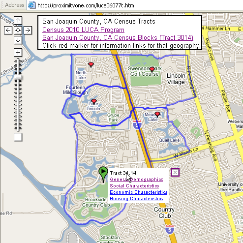
Click the red marker as shown in the above view. It turns green and the mini-html table appears. Click the link for General Demographics. The General Demographics profile is accessed using the Census Bureau FactFinder for this tract. The table shown below appears in a new browser window. Try this for any tract and any link. The number of links are unlimited and the links may go to any URL. 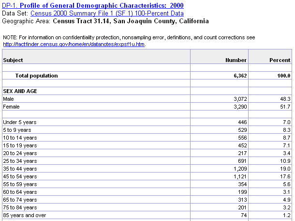
Tract by Block. Click the Census blocks link -- http://proximityone.com/luca06077b.htm. A new window appears showing a portion of tract 3114 in San Joaquin County. The census blocks are shown with blue boundaries. These boundaries are based on the census blocks shapefile reviewed in the CV project described earlier on this page. An XML file is generated for the census blocks boundary file using the Proximity Shp2XML tool. The red markers are located at the geographic centroid of the census block. Use the mouse tool to pass over a red marker and observe how the marker reveals the block code. 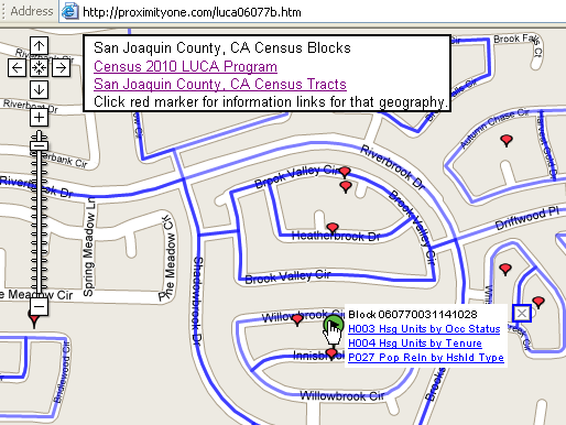
Click the red marker as shown in the above view. It turns green and the mini-html table appears. Click the link for Table P27. Table P27 is accessed using the Census Bureau FactFinder. The table shown belows appears in a new browser window. Try this for any block and any table. 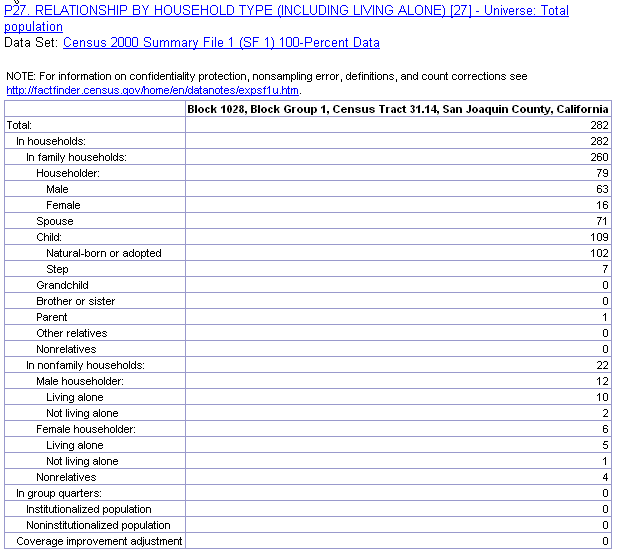
Click the upper right hybrid button. The screen refreshes and shows rooftop level building structures. Block boundaries still in the view. Using this tool you can see where and what types of structures exist in the context of census blocks. Note the following depiction is a graphic. To view a Web page where you can actually click a red marker review other information presented on this page. 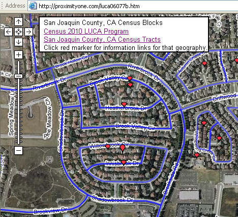
|
|
|