Layer Editor

Contents
The Layer Editor is used to set/manage properties of each layer that are displayed in the Legend Panel. The Layer Editor is started by dbl-clicking a layer name in the Legend panel.
The Legend Panel is located to the left of the map window. The Legend Panel shows all coverages or layers in the active GIS project. When a project is opened, the Legend Panel is populated based on settings previously set for that GIS project.
The Legend Panel shows the name of each layer and possibly much more detail.
Layer Editor Operations Summary
Dbl-click a layer name to start the Layer Editor.
The Layer Editor operates properties of a single layer.
Navigate to a Layer Editor operation by clicking a tab.
Layer Editor Tabs
| • | Layer |
| • | Section |
| • | Renderer |
| • | Area |
| • | Label |
| • | Chart |
| • | 3D |
Dallas County, TX Tracts Application
See the related tutorial on using CVGIS to develop a county by census tract thematic pattern map.
http://proximityone.com/mapping_tract_demographics.htm
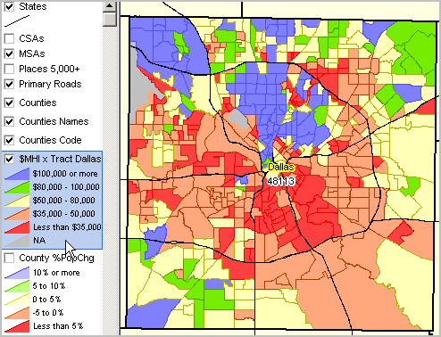
In this application, the Layer Editor is used with the topmost layer (C:\cvgis\1\tl_2010_48113_tracts10.shp).
Start the Layer Editor by dbl-clicking that layer name in the Legend Panel.
Five sections or intervals will be defined/set for this layer, each set to a color.
The number of intervals, subject matter items used to set the range and specific interval end points are designed/set by the user.
In this example, median household income is used as the subject matter.
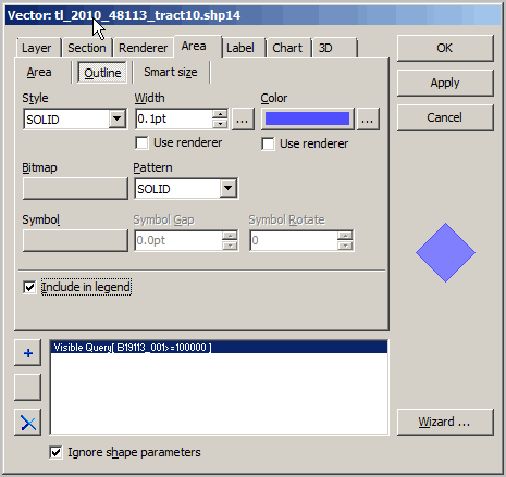
Polygon (census tract in this case) Fill Color Assignment
Click the Area tab. Set the Area as solid and set the sub-tab values for the area and border.
Do this for each of the layers as shown in the above legend/map graphic.
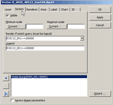
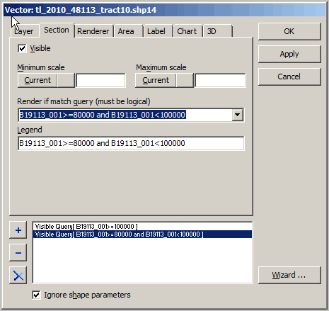
Polygon (census tract in this case) Interval Value Assignment
Click the Section tab. Set the section using the item/field name as illustrated in the following example.
The following view shows setting the topmost interval.
The following view shows setting the second interval.
Set all interval/section values and click OK. The map view now shows your settings.