Export Layer

Contents
Export a shape by using the File>Export Shapefile feature.
This is a useful feature to export a portion of a shapefile often based on a query.
For example, use this feature with a U.S. by county shapefile
... apply a query to select only one state
... create a state specific state by county shapefile.
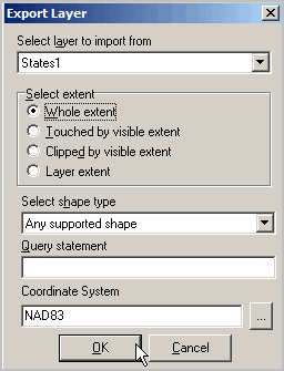
Select the name of the layer to be exported (name assigned within the GIS project).
Select the scope of geographic extent.
Select shape type (point, line, polygon).
Set query statement (e.g., ST='48')
Query statement
-- an SQL statement applied to the shapefile dbf fields.
-- enables subsetting extracted shapefile based on specified criteria.
Select coordinate system.
Coordinate System
-- optionally select a different projection (coordinate system) than the current projection.
Click OK to start conversion.
Specify the output file name in the save dialog.
Processing then begins.