US1 GIS Project

Contents
The US1.GIS GIS project is included with all versions of CV XE GIS.
It is the default GIS project and used at CV XE GIS start-up.
In this section:
1 - US1.GIS Project Start-up View (below)
3 - Layers in US1.GIS Project with Fields List by Layer
4 - Field descriptions for selected layers in panel at left
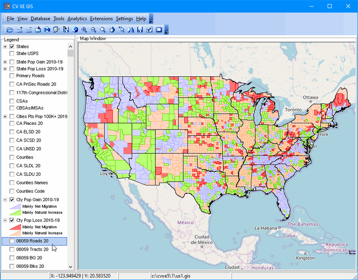
US1.GIS Project Start-up View
The CV XE GIS default start-up view is shown below. Click link for larger view (expand browser window for best view). This view shows patterns of population change by county for the period 2010 to 2019. Color patterns in the legend at left of map show counties gaining and losing population and why the change occurred (migration vs natural increase). See more about examining county population trends (http://proximityone.com/countytrends2019.htm).
Layers in US1.GIS Project
.. layers with same File name contain the same attributes.
.. all layer national scope unless otherwise specified.
.. polygon shapefiles unless otherwise indicated.
| Layer | LayerName | LayerCaption | Source/Name |
| 1 | States1 | States | cb_2018_us_state_500k_popest2019.shp |
| 2 | State code | State USPS | cb_2018_us_state_500k_popest2019.shp |
| 3 | State Gain | State Pop Gain 2010-19 | cb_2018_us_state_500k_popest2019.shp |
| 4 | State Loss | State Pop Loss 2010-19 | cb_2018_us_state_500k_popest2019.shp |
| 5 | Primary Roads | Primary Roads | tl_2019_us_primaryroads.shp |
| 6 | CA PriSec Roads 20 | CA PriSec Roads 20 | tl_2020_06_prisecroads.shp |
| 7 | CD117 | 117th Congressional Districts | cb_2019_us_cd116_500k.shp |
| 8 | CSAs | CSAs | cb_2019_us_csa_500k.shp |
| 9 | CBSA1 | CBSAs/MSAs | cb_2019_us_cbsa_500k_pop19.shp |
| 10 | Cities Points | Cities Pts Pop 100K+ 2019 | cb_2019_us_place_500k_pts_pop19.shp |
| 11 | CA Places 20 | CA Places 20 |
tl_2020_06_place20.shp California cities/places |
| 12 | CA ELSD 20 | CA ELSD 20 |
tl_2020_06_elsd20.shp California elementary school districts |
| 13 | CA SCSD 20 | CA SCSD 20 |
tl_2020_06_scsd20.shp California secondary school districts |
| 14 | CA UNSD 20 | CA UNSD 20 |
tl_2020_06_unsd20.shp California unified school districts |
| 15 | Counties | Counties | cb_2019_us_county_500k_pop19.shp |
| 16 | CA SLDL 20 | CA SLDL 20 |
tl_2020_06_sldl20.shp California state legislative districts lower |
| 17 | CA SLDU 20 | CA SLDU 20 |
tl_2020_06_sldu20.shp California state legislative districts upper |
| 18 | Counties Names | Counties Names | cb_2019_us_county_500k_pop19.shp |
| 19 | Counties Code | Counties Code | cb_2019_us_county_500k_pop19.shp |
| 20 | Cty Pop Gain 2010-19 | Cty Pop Gain 2010-19 | cb_2019_us_county_500k_pop19.shp |
| 21 | Cty Pop Loss 2010-19 | Cty Pop Loss 2010-19 | cb_2019_us_county_500k_pop19.shp |
| 22 | 06059 Roads 20 | 06059 Roads 20 |
tl_2020_06059_edges.shp Orange County, CA Edges/Roads |
| 23 | 06059 Tracts 20 | 06059 Tracts 20 |
tl_2020_06059_tract20.shp Orange County, CA 2020 Tracts |
| 24 | 06059 BG 20 | 06059 BG 20 |
tl_2020_06059_bg20.shp Orange County, CA 2020 Block Groups |
| 25 | 06059 Blks 20 | 06059 Blks 20 |
tl_2020_06059_tabblock20.shp Orange County, CA 2020 Blocks |
| 26 | 06059 Tracts 10 | 06059 Tracts 10 |
tl_2020_06059_tract10.shp Orange County, CA 2010 Tracts |
| 27 | 06059 BG 10 | 06059 BG 10 |
tl_2020_06059_bg10.shp Orange County, CA 2010 Block Groups |
| 28 | 06059 Blks 10 | 06059 Blks 10 |
tl_2020_06059_tabblock10.shp Orange County, CA 2010 Blocks |
| 29 | BaseLayer | BaseLayer | mapquest openstreetmaps tiles.ttkwp |
| 30 | World States | World States | world_states_provinces.shp |
| 31 | States1 | States1 | cb_2017_us_state48.SHP |
Layers in US1.GIS Project with Fields List by Layer