Export Layer

Contents
File>Export Shapefile exports a user selected shapefile from the active GIS project to a different shapefile name based on query and/or different projection.
Availability
Levels 2, 3
Usage
Main menu File>Export Layer
Related Information
...
Illustrative Views
"Select layer to import from" is the layer to be used as source layer.
In this example, the query "stab='MO'" is used -- the processing will subset the national file to a MO (Missouri) only shapefile.
The projection/coordinate system is not changed.
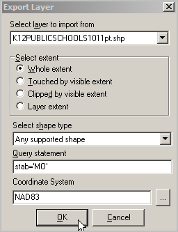
Upon clicking OK, the output filename save dialog appears. Processing then begins.
Query statement
-- an SQL statement applied to the shapefile dbf fields.
-- enables subsetting extracted shapefile based on specified criteria.
Coordinate System
-- optionally select a different projection (coordinate system) than the current projection.