|
|
|
Integrating 2003 County Population Estimates into Shapefiles for Visual Analysis  The Census Bureau released the July 1, 2003 U.S. by county population estimates (and components of
change) in April 2004.
These data are important as they are believed to be the most accurate county level population estimates
available, developed through a coordinated process involving input from specialists in all states.
In addition, these population estimates are regarded as official for all Federal programs,
most state and local government programs, and in other applications requiring the
"most current official county population data."
See the press release for an overview.
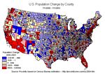
Using Proximity dBMerge, you can create a map file (shapefile) containing the population estimates and components of change data. In addition to the July 1, 2003 population estimates, updated/revised estimates are provided making the annual series from 2000 through 2003. Within minutes you are able to use these data in thematic maps and for visual analysis. Prepare maps such as the one shown on this page. Follow the steps outlined below.
CTY2003 Data Fields
goto top | ||||||||||||||||||||||||||||||||||||||||||||||||||||||||||||||||||||||||||||||||||||||||
|
|