|
Accessing Metro Data |
  
|
| Show/Hide Hidden Text |
|
Accessing Metro Data |
|
| Show/Hide Hidden Text |
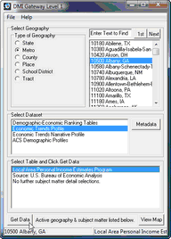 Select the MSA geography radiobutton and the geography listbox populates with MSA codes and names.
DblClick a state and it appears as the selected geography in the lower left section of the status bar.
MSAs used in DMIGateway are the current definition MSAs. There are no Census 2000 summary file data tabulated for current definition MSAs (only previous, Census 2000 area definitions) thus the summary file data are not available.
When Metro geography is selected, the dataset options include:
Demographic-Economic Ranking Tables • Various demographic-economic items Proximity
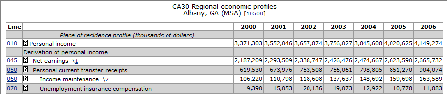
Economic Trends Profile • time series economic data (2000 forward) -- regional economic profile
Economic Trends Narrative Profile • A narrative summary of trends over the past 10 years • Bureau of Economic Analysis regional economic information system
Demographic Profiles • Latest demographic profiles • Census Bureau American Community Survey 1-year estimates -- areas with population 65,000 or more 3-year estimates -- areas with population 20,000 or more |
Select a subject matter option. |
With the settings shown in the above panel, click Get Data and the table presented below (partial view) is displayed in your browser.
|
|
Page url: http://proximityone.com/dmigateway/guide/index.htm?metro_data.htm