

View Menu |

|

|

|

|

|
||
View Menu |
|
|
|
|

|

|
View Menu |
|
|
|
|
|
||
View Menu |
|
|
|
|
|
|
|
|
||
View Menu
From the view menu, the different map types can be selected: satellite, map, hybrid, terrain. In addition, on the displayed map type, the bicycle roads, panoramio pictures, traffic (where available), streetview (where available) can be displayed
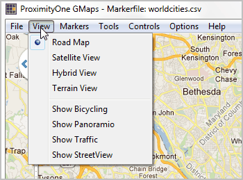
Road Map
Satellite View
Hybrid View
Terrain View
Show Bicycling
Show Panoramio
Show Traffic
Show StreetView
Road Map
Satellite View
Hybrid View
Terrain View
Show Bicycling
When set to true, and if available in country of interest, bicycle trail information can be displayed on the map.
Show Panoramio
When set to true, the Panoramio functionality is activated, showing thumbnails of posted pictures.
The pictures are loaded when the thumbnail is clicked.
Show Traffic
When set to true, and if available in country of interest, traffic information can be displayed.
Availability: https://spreadsheets.google.com/spreadsheet/pub?key=0Ah0xU81penP1cDlwZHdzYWkyaERNc0xrWHNvTTA1S1E&gid=0
Show StreetView
StreetView options:
•DefaultLatitude: Sets the latitude value for the default street view position when StreetView is launched.
•DefaultLongitude: Sets the longitude value for the default street view position when StreetView is launched.
•Heading: Defines the heading at the street view position. Valid values are between 0 and 360 degrees.
•Pitch: Defines the pitch (view angle) for the street view. Valid values are between -90 and 90 degrees.
•Visible: When set to true, the street view is displayed.
•Zoom: Sets the zoom factor for the street view. Valid values are between 0 and 5.
