Proximity
|
Proximity |
|
|
|
|
|
|
|
|
|
|
Hawaii Map Applications -- Census 2000 Blocks Comprising Voting District Areas -- Census 2000 Blocks Comprising High School Complex Areas Voting Districts and Census Blocks
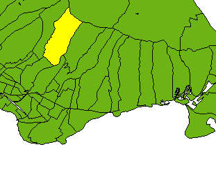
The map shown below depicts voting districts (green areas) in Honolulu,
in the Diamondhead area, with voting district 2307 highlighted in yellow.
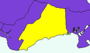
High School Complexes and Census Blocks
The map shown below depicts high school complex (HSC) areas (purple areas) in Honolulu,
in the Diamondhead area, HSC 10813 highlighted in yellow.
How these Maps were Created
These maps are intended to be illustrative of how a geographic information system can be used to
show relationships between different types of geographic areas. These maps required three map layers
or themes:
(1) a shape file comprised of census blocks where the corresponding dbase (dbf) file
contained the census tract code, census block code, high school complex code, and voting district
code,
(2) a shape file comprised of voting districts, and
(3) a shape file comprised of high school complex areas.
The census block layer dbf provides an equivalency file relating each census block to a voting district
and high school complex area. To show an area highlighted as yellow, a query is performed on that layer/theme
where the geographic area name/variable of interest is set equal to a particular code. In one
query the voting district was set equal to ' 2307'. In the other query, the high school complex area
code was set equal to '10813'.
|
|
|
|
|
|
|