
|
|
|
Hope Community GeoDemographics -- a loGIStical strategies briefing document Hope Community Inc. is a New York city community based not-for-profit affordable housing organization focused on the East Harlem community and surrounding neighborhoods. Through economic development, social service partnerships and other efforts, it seeks to enhance opportunities and infrastructure. See this document online. HopeCI and similar organizations need geographic, demographic and economic data to better assess situations. By knowing more about where we are, and how change is occurring, we are better able to develop and target activities and operations for improvement. This brief has been developed to illustrate access to and use of some of these data. HopeCI Geography HopeCI operations are focused in the area shown in the following map. This view characterizes the area with a census tract overlay. These statistical areas, covering the U.S. wall-to-wall, often equivalence neighborhoods and average 4,000 population. The census tracts are shown with bold boundaries and labeled with yellow 15-character tract "geocodes". Consider two tracts focused here .. tracts 36061019800 (see pointer) and adjacent tract 36061019600. Click links to see how many people live here and more about their living environment. Map at right is a broader view of area shown below. 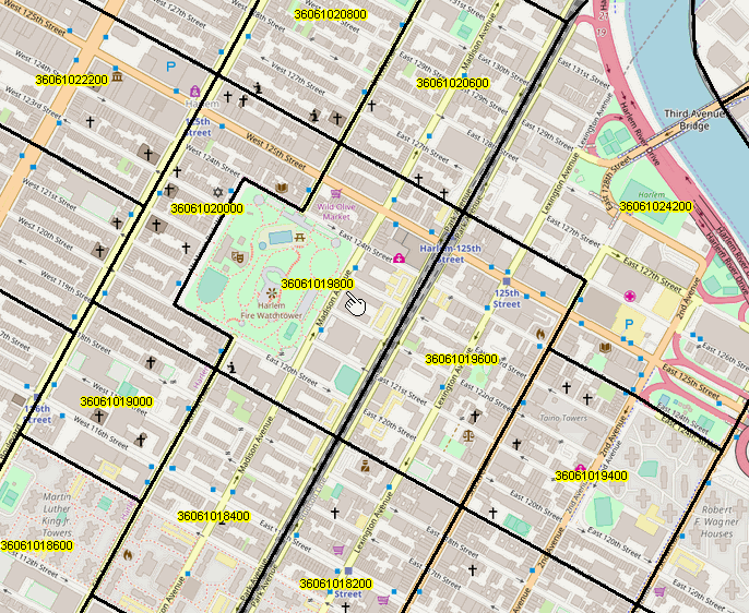 Adding Other Data This is a start, a foundation. Join in the Accessing & Using Demographic Web Sessions. Participate every week. Learn about examining patterns of food insecurity. How to collect, manage & assess patterns. Explore metrics associated with COVID and vaccination patterns. How to measure and develop insights into workforce issues: remote working, employment opportunities. Educational infrastructure and households. Examine affordable housing using data driven methods. Resources to communicate with and inform stakeholders. |
Explore Using Web GIS Use the Visual Data Analytics (VDA) Web GIS. Click here to start VDA. Below is a broader view of map at left. Cross-hatch area is ZIP 10029. Labels show tract code and Hispanic population. See how-to-create details here. Equip stakeholders with employable skills to use these tools. Find out what this map can tell you; share with others; Advance communications. 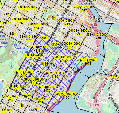 Examine Location-Based Demographics Characteristics of the census tract (36061016600) associated with the Hope CI location (174 E. 104th Street, New York, NY 10029) based on ACS 2019 are shown below. This profile can be generated for any address using the Location-Based Demographics tool.
Accessing & Using Census 2020 Stay current with Census 2020 data access & use developments. .. analyzing data down to the census block level. loGIStical Strategies .. Ann Barclay .. abarclay@proximityone.com .. information solutions from ProximityOne & Tsukasa Contact us or call 888-364-7656 |