|
|
WebGeoData Operations More Information |
IMAGE: Modeling, GIS mapping, geocoding and data integration -- develop updated demographic-economic estimates and projections based on your models -- geocode your address data and view results on your map -- build your map project by combining multi-sourced data Use the modeling features of IMAGE to develop estimates and projections of demographic-economic characteristics. Working with you, we develop predictive models that specify cause and effect relationships for subject matter items to facilitate your planning and analysis. We build the database required to develop estimates and projections and provide initial scenario projections. Visually analyze the results of the estimates and projections using the IMAGE GIS features. The Proximity Integrated Modeling and Geographic Encoding software (IMAGE) features the combined GIS operations available in the Proximity CommunityViewer GIS and TLFGeocoder with new capabilities. An important feature of IMAGE is the ability to access no-fee Web-sourced map file/shapefiles and TIGER/Line files and automatically integrate these data into a mapping project. This eliminates the requirement to know where the files exist on Webservers, how to access and use the files, and how to build mapping project files. Estimates & Projections. Annual or more frequent demographic-economic estimates and projections updates are required in areas experiencing substantial net in- or out-migration, changes in the business/employment infrastructure, or changes in population composition. New development might make it necessary to modify assumptions. Estimates and projections are based in part on historical trends; as these data series are updated, the estimates and projections also need to be updated. Use IMAGE to update your model specifications and database, or we can work with you to implement the updates. Then you can develop alternative scenario projections based on updates to your integrated model and database. Geocoding Data. Use IMAGE to visually analyze your geocoded data in the context of other data. The following view shows shows a zoom-in to an area in Honolulu, HI. Suppose that you want to locate all streets in an area with a certain name. Use the "Find All" operation (button located in right section) to perform this type of task. In this example, the Find All was performed searching for streets with the words "kahala ave" (see address edit box). Streets meeting the criteria are automatically highlighted in red (see map). An exact address could have been used instead. 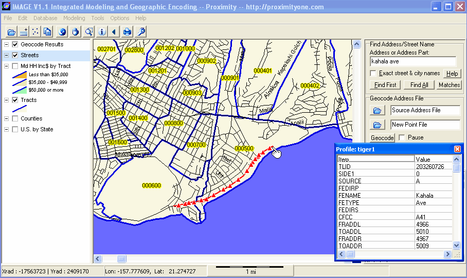
The identify tool is used to profile a specific street segment. The profile appears in the box at the right of the map. Here you can view the street name and other items such as left- and right-side segment high and low address ranges, ZIP codes, and other attributes. IMAGE enables you to automatically, and without fee, download the Census Bureau TIGER/Line files and interface those data into your mapping application. You do not need to know where the files are located on the Web or how they are added into your map project. The streets shown in the above map have been displayed using the TIGER/Line data. See the section on WebGeodata for an overview of the steps to download the TIGER/Line files, related shapefiles, and automatically build a map project file. You can then open the map project and obtain views such as the one shown above. The above view also shows how IMAGE can provide blended views of multi-sourced data. The Honolulu County, HI by census tract shapefile was added to the project. Tract boundaries appear in blue. The census tract code appears with the yellow highlight. Thematic Maps. The next view shows the same general area as above. The "kahala ave" street segments are highlighted. The county by census tract shapefile has been augmented by adding median household income. The legend shows color patterns for three income levels as reflected in the map by census tract (blue boundaries). The identify tool is used to display a profile of the census tract where the "kahala ave" street segments are located. The profile shows median household income (item DP3058) of $107,217. 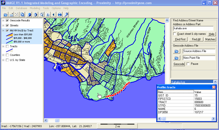
More Information. Contact Proximity for additional information on how you can acquire IMAGE. Be sure to add the text "IMAGE" in the message/comments area and any other notes pertaining to your interests. [goto top] |
|
|