|
|
|
Multicultural Geodemographic Analysis Race and ethnic origin are fundamental demographic categories useful in understanding multicultural composition of an area. The decennial census is the primary barometer by which race and ethnic origin are measured both in terms of geographic scale and classification detail. Several updated data resources can help examine multi-cultural demographic change since 2000. What data resources are available for multicultural analysis? How can you place these data in a context that can help you make decisions about reaching a particular multicultural population? 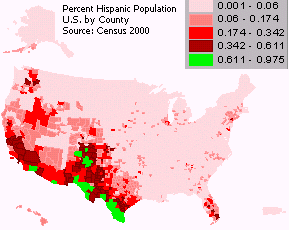 Use geographic information system technology with Census 2000 data,
integrated with your data, to better understand
the composition and dynamics of multicultural population in relation to your organization's operations.
Use geographic information system technology with Census 2000 data,
integrated with your data, to better understand
the composition and dynamics of multicultural population in relation to your organization's operations.
This map depicts the percent Hispanic population for the U.S. by county. As described in this webpage and related paper, there are thousands of data items relating to multicultural analysis available to you. The paper Multicultural Geodemographic Analysis to describes how to develop multicultural data access and use capacities to meet your goals and objectives. If you have not yet registered, you will need to register to obtain a userid to access the paper (no fee). The paper covers:
|
|
|