|
|
|
What These Data Can Tell Us Geospatial Analysis Online Reference Maps Methodology School District Demographics Main Page |
Missouri School District Demographics
Displays of Table 1 through 4 results in comparative analysis display of the 3 areas selected. The resulting profile displays the subject matter data for each of the area(s) selected, organized as columns. To select only one area to be presented in the data display, set the selection to "None" for area 2 and area 3. To select only two areas, set the selection to "None" for area 3. Source and Uses of the Data [goto top] Data made available via this Web page have been developed by Proximity for subject matter categories corresponding closely to the Census Bureau Census 2000 "demographic profiles." Why use these data? Because they represent the most widely used cross section of demographic data that can be used to assess the overall socioeconomic composition of an area. In addition, using this set of data items makes it easier to compare attributes of school districts with those of counties, communities, census tracts, ZIP code and other types of areas. The scope and content of the demographic profiles is described in the technical documentation located at http://www.census.gov/prod/cen2000/doc/ProfileTD.pdf. The technical documentation contains a glossary and related information that may be useful to users of data made available through this Web page -- the comparative analysis profiles. The Census Bureau developed the demographic profiles only for states, counties, places, and other selected governmental jurisdictions. The Census Bureau has not developed these subject matter summaries for smaller geographic areas such as census tracts and school districts. What These Data Can Tell Us [goto top] These data provide important information that can facilitate planning and evaluation. They help enable analysis of the following types of application areas. • Compare school district characteristics using a composite set of key indicators. • Assess 'state of education' -- educational attainment by school district. • Analyze attributes of the households that suggest different educational needs. • Assess special education needs using data on children with disabilities. • Assess size of certain populations of interest. • Examine patterns of labor force/employment infrastructure in relation to education. • Assess the need/demand for wide-ranging education-related programs and services. • Examine English language proficiency among school districts. • Analyze number of children in school systems for health and youth development. Geospatial Analysis [goto top] Data displayed in a tabular form can also be viewed in a geospatial analysis context. In the following maps, geographic information system (GIS) software is used to view a Belton, Grandview, and Hickman school districts in Missouri. Data for the three Kansas school district may be viewed using the Kansas school district demographics Web page. County boundaries are red. Kansas City MO-KS Metropolitan Area 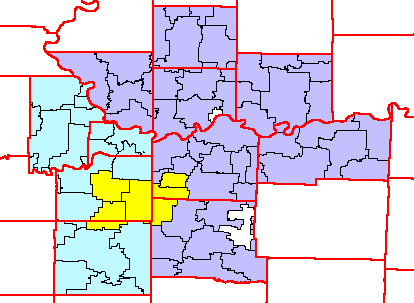 Belton, Grandview, and Hickman MO school districts 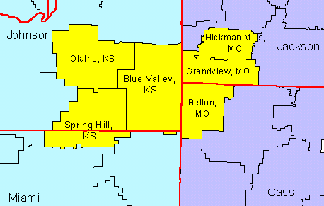 Online Reference Maps [goto top] Maps of school districts, in the context of counties, communities, census tracts, streets, schools, and other features may be viewed using the Census Bureau Web-based Factfinder (http://factfinder.census.gov). Getting the Maps, Step-by-Step. Here is a step-by-step summary describing how to get a map for districts of interest and see related geography.
Data presented in Table 1, General Demographics, are derived from the Summary File 1 (SF1) complete-count data. SF1 data are summarized for the low level geography of census block. School districts may be defined as a unique set of census blocks. School districts boundaries, as used in Census 2000, do not split census blocks. Data presented in Tables 2-4 are derived from the Census 2000 Special Tabulation through use of a set of algorithms developed by Proximity. Terms of Use Data made accessible through this Web page are made available for the reader's end use. Data presented in tabular displays may be redistributed without further authorization provided that the tables are provided in their entirety, full reference is made to the source of the data and display, and no income, directly or indirectly, is made through use of these data. For other uses, please use the contact link at the bottom of this page. [goto top] |
|
|