|
|
|
Subscribe What These Data Can Tell Us Geospatial Analysis Online Reference Maps Methodology School District Demographics Main Page |
New York School District Demographics This page has now been updated. Please see http://proximityone.com/nysdd1.htm. 1990 Census and Census 2000 demographic comparative analysis profiles for State of New York school districts may be viewed using this Web page. This web page has two objectives: • to demonstrate scope and availability of Census 2000 school district demographic data developed by Proximity (a proprietary product uniquely available from Proximity), and • to show how the Census 2000 demographics can be used with 1990 Census school district demographics for analysis of State of New York school districts. Data made available through this Web page are for demonstration purposes. Although this Web page provides access to only a selected set of districts, the database has now been developed for all districts in the state. See details as to the source and uses of these data and how they fit into the broader scope of Census 2000 and school district demographic data. Viewing Profiles. To view profiles for areas of interest, proceed with the following the four steps. If you click on display, step 4, as shown in the default state, comparative analysis profiles are generated for the Census 2000 districts of Gilbertsville-Mount Upton Central SD, Morris Central SD, and Unadilla Valley Central SD (see map) and the 1990 Census districts of Gilbertsville, Mount Upton, and Syracuse. See explanation as to why the selection Census 2000 districts and 1990 Census districts are specified separately. More about Table/Display Structure/Content. This Web page provides access to selected New York school districts. Displays of Table 1 through 4 results in comparative analysis display of the 3 areas selected based on Census 2000 data. Three school districts are always selected; any three districts may be selected in any order. The resulting profile displays the same subject matter data for each of the three districts organized as columns. Features Unique to Table 5. Table 5 displays data from the 1990 Census. This table includes data on relevant children. For the 1990 Census, relevant children are defined as persons 3 to 19 years of age who are not high school graduates who are grade relevant to grades for which education is offered by that school district. Sections of Table 5 which contain data for attributes of relevant children are shown with a background color of light blue in the stub section. The lower portion of Table 5 presents data from the 1989-90 Common Core of Data (CCD) non-fiscal and fiscal data program. This section of the table is yet to be formatted and documented. It should be ignored in the present version. Times series annual data will be added from the CCD program soon. Selecting Geography [goto top] In many states the geographic area covered by some school districts has changed between 1990 and 2000. In some states this change has been dramatic. In other states there has been no change. New school districts appear and others are dissolved. Some districts merge as a whole with other districts. Some districts are split and reorganized without pattern with other districts. In some cases the Federal geographic code that was assigned to one district in 1990 is now associated with another district in 2000. Due to these variations, the selection of 1990 Census geography and Census 2000 geography (in the above form), for display of corresponding demographic data is handled by separate selection boxes. In the default specification (above form) the Census 2000 school district of Gilbertsville-Mount Upton is the separate 1990 Census districts of Gilbertsville and Mount Upton. The Federal code used for Gilbertsville-Mount Upton is not a valid Federal code for any district in 1990. The district Unadilla Valley Central SD (contiguous to Gilbertsville-Mount Upton), also used as a Census 2000 default selection, did not exist by that name in the 1990 Census. The Federal code used for Unadilla Valley Central SD in Census 2000 was used for another district in 1990. By separating the selections, it is possible to select the 1990 districts comprising the Census 2000 Gilbertsville-Mount Upton district (Gilbertsville and Mount Upton) and have the data displayed separately. This enables the user to view the impact and sum the components. Source and Uses of the Data [goto top] Data made available via this Web page have been developed by Proximity for subject matter categories corresponding closely to the Census Bureau Census 2000 "demographic profiles." Why use these data? Because they represent the most widely used cross section of demographic data that can be used to assess the overall socioeconomic composition of an area. In addition, using this set of data items makes it easier to compare attributes of school districts with those of counties, communities, census tracts, ZIP code and other types of areas. The scope and content of the demographic profiles is described in the technical documentation located at http://www.census.gov/prod/cen2000/doc/ProfileTD.pdf. The technical documentation contains a glossary and related information that may be useful to users of data made available through this Web page -- the comparative analysis profiles. The Census Bureau developed the demographic profiles only for states, counties, places, and other selected governmental jurisdictions. The Census Bureau has not developed these subject matter summaries for smaller geographic areas such as census tracts and school districts. Relationship to Census 2000 School District Special Tabulation. The Census Bureau is in the process of developing the Census 2000 school district special tabulation (SDST 2000) under sponsorship of the U.S. Department of Education. The SDST 2000 data are expected to become available in the spring of 2003 (May). In contrast, the data demonstrated accessible via this Web page are available now. As the SDST 2000 data become available, the corresponding sections of the underlying Proximity database will be updated so that the Census 2000 data are identical. The comparative analysis format used in the display of the data for multiple school districts is a proprietary structure developed by Proximity. The comparative analysis capacity will be extended as the SDST 2000 data are released and Excel based files paralleling the comparative displays will be downloadable. The resources demonstrated through this Web page are transportable. That is, the html pages, software and databases may be placed on any Windows compatible HTTP server. Data dissemination plans for the NCES SDST 2000 data will be resident on the NCES server only, making it more difficult to integrate the SDST 2000 data with other data -- a key attribute of the evolving Proximity structure. Neither the Census Bureau nor the U.S. Department of Education will provide access to 1990 Census data beyond what now exists. This makes online access to 1990 Census school district demographics only available through Proximity developed resources. In addition, there is no capacity, other than through the Proximity resources, to access area-equivalent data for school districts enabling the comparison of characteristics in 1990 with characteristics in 2000. What These Data Can Tell Us [goto top] These data provide important information that can facilitate planning and evaluation. They help enable analysis of the following types of application areas. • Compare school district characteristics using a composite set of key indicators. • Assess 'state of education' -- educational attainment by school district. • Analyze attributes of the households that suggest different educational needs. • Assess special education needs using data on children with disabilities. • Assess size of certain populations of interest. • Examine patterns of labor force/employment infrastructure in relation to education. • Assess the need/demand for wide-ranging education-related programs and services. • Examine English language proficiency among school districts. • Analyze number of children in school systems for health and youth development. Geospatial Analysis [goto top] Data displayed in a tabular form can also be viewed in a geospatial analysis context. In the following maps, geographic information system (GIS) software is used to view a thematic map of English language proficiency for school districts in the Denver, Colorado area. The following graphic shows the Census 2000 districts of Gilbertsville-Mount Upton Central SD, Morris Central SD, and Unadilla Valley Central SD. County boundaries are blue. Major roads are shown in gray. 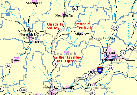
Online Reference Maps [goto top] Maps of school districts, in the context of counties, communities, census tracts, streets, schools, and other features may be viewed using the Census Bureau Web-based Factfinder (http://factfinder.census.gov). Getting the Maps, Step-by-Step. Here is a step-by-step summary describing how to get a map for districts of interest and see related geography.
Demographic data for school districts have been developed by aggregating census block and census block group level data to corresponding school district geography. Data presented in Table 1, General Demographics, are derived from the Summary File 1 (SF1) complete-count data. SF1 data are summarized for the low level geography of census block. School districts may be defined as a unique set of census blocks. School districts boundaries, as used in Census 2000, do not split census blocks. Though tedious, development of the SF1 school district data from census blocks is straight-forward and not subject to any errors of estimation. Data presented in Tables 2-4 are derived from the Summary File 3 (SF3) sample-based estimates data. SF3 data are summarized for the low level geography of census block group. As shown in the above map, school districts do split census block group (BG) boundaries. School district summary data in Tables 2-4 is developed by aggregating BG summary data for the corresponding area. In those cases where a BG is split by the school district, the BG data are apportioned to the school district(s) splitting the BG. The allocation of the data is based on the portion of the BG in the school district as determined by the component census blocks. The allocation of the data is based on the total population, households, or housing units, depending on the specific subject matter. An error of estimation exists in all SF3 data at all geographic levels since the data are based on sample-based questionnaire data. In the case of the allocation of split BGs into respective school district area, additional error, albeit small, is also introduced. Terms of Use Data made accessible through this Web page are made available for demonstration purposes and may not be used for production or operational applications without further authorization. Any public school district may use these data for their own district without fee provided that (1) a full reference as to source is provided in all uses and (2) a request to use the data be made using the contact link provided at the bottom of this Web page (name and e-mail address of the appropriate business officer or superintendent must be provided). [goto top] |
|
|