
|
|
|
|
-- results from Census 2020 to the census block level -- viewing & analyzing demographics using the VDA Web GIS -- developing insights into patterns, change and trends -- geographic, demographic, economic characteristics .. the initial Census 2020 demographics by census block and higher level geography became available August 12, 2021. Use the Visual Data Analytics (VDA) Web GIS to access/use these data optionally with your data .. we invite you to join in! This section is focused on the VDA "Congressional Districts" GIS project. VDA Congressional Districts Project Start-up View &mbsp; .. patterns of economic prosperity The following graphic shows the VDA start-up view using the "Congressional Districts" project. VDA operates with most browsers. Start using VDA to dynamically see the view shown below. This view shows patterns of the economic prosperity by Congressional District based on the America Community Survey 2019 1-year estimates. Easily, flexibly and quickly shift the view to your area of interest.  Congressional Districts, and many other types of geographic areas, are now in the process of redistricting using the Census 2020 P.L. 94-171 data. Use VDA, as described in this section, to view/analyze Census 2020 demographic attributes of congressional districts in a mapping/geospatial analysis manner or in a tabular/spreadsheet form. Or drill down to census block level. .. we will update this project to include the 117th Congressional Districts as redistricting is completed .. state by state updates. The world is in constant change. Keeping up with knowing about the where, what, how and how much of change is and might occur can be challenging. "Knowing" is important for many reasons from understanding opportunities that may exist to learning how change might impact us. Visual analysis using interactive mapping is often the most effective and fastest way to answer many types of geodemographic questions. Communicating and collaborating with others can produce better results using maps than using tabular data alone. Viewing/Analyzing Data from Census 2010, Census 2020 & ACS Use VDA with the ready-to-use VDA "Congressional Districts" project to view/analyze data from Census 2010, Census 2020, American Community Survey down to the census block/block group level of detail. In addition, VDA provides access to current demographic estimates and projections to 2060. Blend these data with your data. Examine how current and evolving trends might impact you and your stakeholders. About VDA, Credits, Using this Document.. goto top This document provides an overview of the VDA Web GIS and instructions on its use. VDA has been developed by Warren Glimpse/ProximityOne/Alexandria, VA USA and Takashi Hamilton/Tsukasa/Osaka, Japan. All that is required to use VDA is a Web browser. iOS and Android versions are supported. VDA uses the same core structure as the Windows desktop CV XE GIS. VDA offers capabilities to develop and share your own GIS projects, securely and efficently. Use VDA in your online meetings. Collaborate on geographic and demographic economic topics. There is nothing to install. Use VDA anywhere. VDA is available in these forms: • Web-based interactive access using a browser and HTML .. get started now, click this link. • Installed on your hosted server for your private (e.g., organization-wide) use. • Provided as a complete turnkey package for use on your site with related GIS project developer tools. .. integrate your own data. Getting Started .. goto top Login Form When VDA starts (click this link to start VDA), enter your userid and password in the login screen. 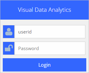 . .Registering as a New User To register as a new user click "Signup" on the Login form (above), the following registration information appears. the following is just an example. Start VDA to signup and perform this step.
SignUp to use VDA ...
1) Add your name and email address below. Then click OK. 2) You will receive an e-mail with your initial password. 3) You can use the VDA Login form and start VDA. See more information here user name email address You will receive an email confirming your account has been created and providing an initial password. You may then start VDA and login with your userid and password. • your userid is your e-mail address • your password is initially the one sent to you by VDA admin • you can optionally change your password on the login form. Signing up to use VDA provides Level 1 access. Note that Level 1 users do not have access to all features and that a 10-minute automatic logoff will occur during sessions. Optionally login and resume VDA use. After VDA Login After logged in, the VDA User Profile form appears. Select the Congressional Districts project to use geography and data described in this section. Click the project name; it turns blue. Then click the Select project button. VDA starts and the selected project opens. 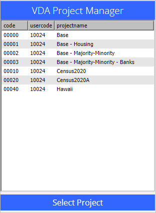 Changing Password After login, change your password on the VDA User Profile form (see above) by clicking the Change Password button at the bottom of the form. A new form appears where you can enter your new password. Recommended Getting Started Steps .. a simple tutorial Start using the "Congressional District" project. From the start-up view of the project: • Enter a ZIP code in the Find ZIP Code edit box above the Map Window. • If you use ZIP code 22309 (try it now), the Map Window refreshes to a zoomed focus on this ZIP code. • As the ZIP code query is performed, a demographic-economic profile is diaplayed in the Profile Panel (lower left). .. see that the ZIP Code (ZCA) shows value 22309. .. see that the total population for this ZIP Code is 37,464 in the profile panel in lower left. • Make these changes to layers showing in the Legend Panel. .. uncheck "$MHI x CD ACS 2019" (removed from map). .. uncheck "World by Country" (removed from map). .. check on the OpenStreetMaps layer. .. the view now shows the selected ZIP code in context of roads, streets, topography. Augment the view to show CDs and CD code: .. check on the Congressional Districts Bold layer. .. check on the Congressional Districts Code layer. The view now shows CD VA 8 (and other districts) with bold orange boundary. ZIP 22309 (Miunt Vernon area shows as crosshatched. 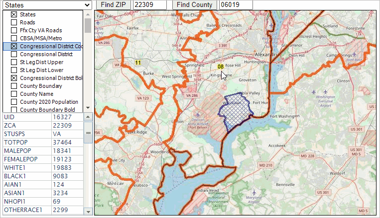 Layers Included in the GIS Project .. goto top The Congressional Districts GIS project is comprised of a set of layers listed below. A layer corresponds to a shapefile or SQLite geographic file that is shown in the Map Window. Turn on/off layers to suit your preferences by checking layer name checkboxes shown in the Legend Panel. Upload your own layers to view your geography/data with this set of layers. Most layers (designated by "US" are U.S. national scope 2020 geography. By design most layers contain Census 2020 demographics only. Users can add their own layers. The ZIP code layer, near bottom of list, includes ACS 2019 5 year data.
- States (US)
- Roads (US) - Ffx Cty VA Roads (Fairfax County, VA) - Congressional District Code (US) - Congressional District (US) - State Legislative Districts Upper (US) - State Legislative Districts Lower (US) - Congressional District Bold (US) - County Boundary (US) - County Name (US) - County 2020 Population (US) - County Boundary Bold (US) - $MHI x CD ACS 2019 (US) - Cong Community Code (US) - Cong Community (US) - Cong Community Bold (US) - City/Place Name (US) - Cong Comm Cen2020 (US) - City/Place 2020 Population (US) - City/Place Code (US) - Tract Code (US) - Tract Boundary (US) - Tract 2020 Population (US) - Tract Boundary Bold (US) - 2020 %Asian x Tract (US) - Block Group Code (US) - 2020 %NHOPI x BG (US) - VA Block Code (Virginia) - VA Block Population (Virginia) - VA Block (Virginia) - 2020 %VotingAge x VA Block (Virginia) - ZIP Code (US) - ZIP Code Bold (US) - World by Country - BaseLayer - States1 Not Limited to Congressional Districts .. goto top Most layers in the VDA CD project are national in scope. Mapping and analysis are not limited to CDs. Using Find Address to Focus on Mount Vernon (northern Virginia) Location .. goto top Use Tools>Find Address Get Block feature; zoom to an address. .. George Washington Estate .. 3705 Mount Vernon Memorial Highway, Alexandria, VA 22309 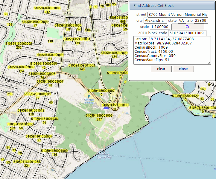
Zoom in & Examining Selected Block .. goto top 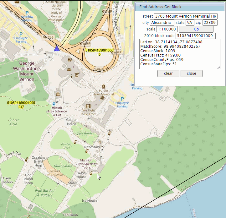
Examining Selected Block Add Blocks Layer .. goto top 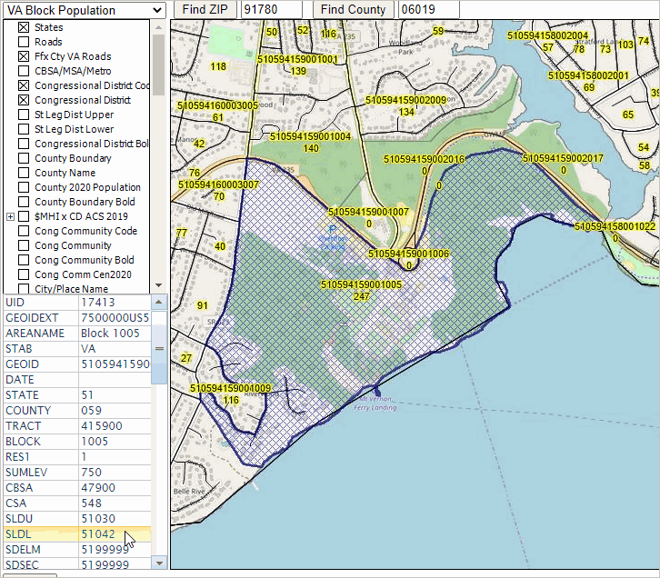
Mapping & Analyzing Census Block GeoDemographics .. goto top The Census 2020 PL 94-171 census block attributes are shown in the table below. Fields in Census Block Layers (scroll section)
Relating Census Blocks to Congressional Communities .. goto top Census 2020 census blocks have been populated with Census 2020 demographics. Congressional Community (CC) demographics have been developed by associating census blocks to CC areas and aggregating census block demographics to the CC polygons. The CC code has been integrated into each corresponding census block record. The following view illustrates how a query can be placed on the census block layer to show census blocks comprising a CC (in this case CC 5108017) 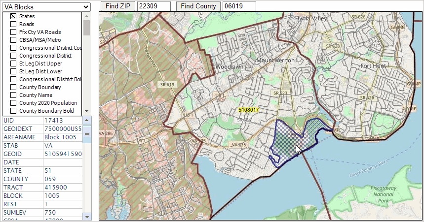
Using the Congressional Community Profile .. goto top When the active layer is set to Congressional Community (CC), click a CC in the map window to display a profile for that CC. The following view illustrates that process. CC 5108017 (VA CD 08 CC 017) is clicked, it shows as cross hatched. The Profile Panel in the lower lower left is populated with the with the attributes of the CC layer. 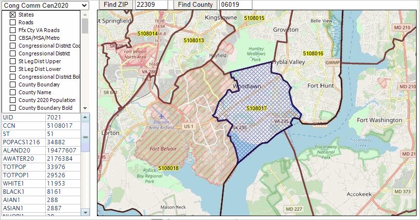 To view the profile with descriptive stubs, proceed as follows: - open the CC 2020 excel profile template - with the CC layer ("Cong Comm Census 2020") set to the active layer, click a CC area in the VDA map window. > the Profile Panel populates. - click the copy to clipboard button below the Profile Panel. - in the Excel spreadsheet, Ctrl-V or paste into cell L1. - the profile should appear as shown below. 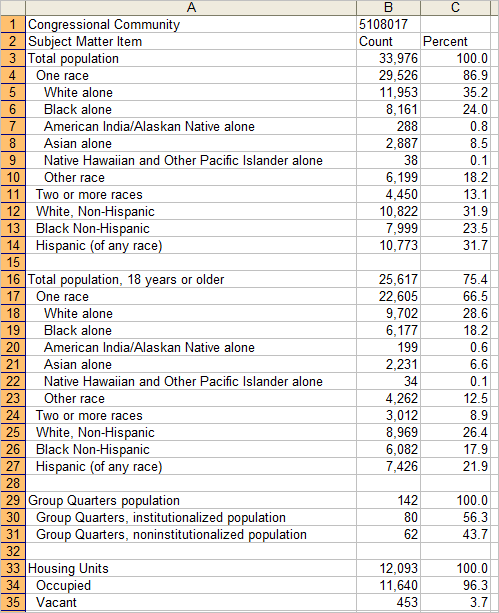 Creating a Census Block Profile .. goto top When the active layer is set to VA Block, click a block in the map window to display a profile for that block. The following view illustrates that process. CC 5108017 (VA CD 08 CC 017) is clicked, it shows as cross hatched. The Profile Panel in the lower lower left is populated with the with the attributes of the CC layer. To view the profile with descriptive stubs, proceed as follows: - open the Census Block 2020 excel profile template - with the VA Blocks layer set to the active layer, click a block in the VDA map window. > the Profile Panel populates. - click the copy to clipboard button below the Profile Panel. - in the Excel spreadsheet, Ctrl-V or paste into cell L1. - the profile should appear as shown below. 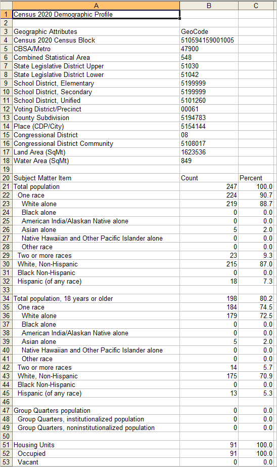 VDA User Interface and Navigation .. goto top See the VDA main section for information on the VDA user interface and navigation Using the Find Address Features .. goto top There are two VDA Find Address features. They are started using the Tools selection from the main menu bar. Option 1 -- Find Address Click Tools>Find Address and the popup shown below appears. Key in an address to be located in the top edit box then click the Go button to show the location in the Map Window. The Map Window refreshes with a zoomed view of the location shown by a blue triangle marker. Using the default address (hawaiian village honolulu) the location/view is illustrated in the following graphic. 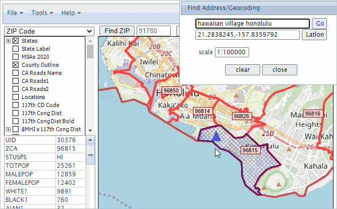 The above view assumes these settings: - the ZIP code layer is selected as the active layer - In the legend panel, .. the ZIP Code Bold layer is checked on .. the $MHI x Tract layer is checked off .. the World by Country layer is checked off .. the OpenStreetMaps layer is checked on ZIP code 96815, where the triangle marker is shown, is then clicked resulting it be cross-hatched and the Profile panel at lower left in the User Interface shows demographic attributes for this ZIP code area (the total population for the ZIP code area is 25,261). The default address setting (hawaiian village honolulu) is used to illustrate that a formal, exact address is not required. Try your own address or these other examples: "1600 pa ave., wash dc" or "central park ny" (no quotes) The latitude-longitude of the address location is shown in the lat-lon edit box in the Find Address form. To place the marker on a point based on latitude-longitude, enter the lat-lon in the edit box and click the latlon button. The zoom-in level can be controlled using the scale setting. 1-100,000 is normally suggested, a 1-1,000 provides more of a zoomed-in view. Option 2 -- Find Address Get Block While Option 1 Find Address is very accurate and uses a flexible location name, ir does not return a Census block code. Find Address Get Block does return the block code. Click Tools>Find Address Get Block and the popup shown below appears. Key in an address to be located in the top edit box then click the Go button to show the location in the Map Window. The Map Window refreshes with a zoomed view of the location shown by a blue triangle marker. This application uses an arbitrary address located in the same area used in the above area (3697 Crater Rd, Honolulu, HI, 96816). 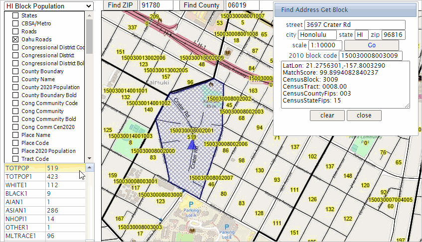 Unlike the Option 1 Find Address, this method identifies the 2010 census block in which the address is located (150030008003009). That census block can be expanded to 15-003-000800-3009 showing the address is located in Census 2010 block 3009 of tract 000800 of county 003 in state 15. Intersection-to-intersection Roads/Streets .. goto top Using the Oahu Roads layer, street segments can be viewed and examined. The street segment corresponding to the address used in the above Find Address example is shown in the following graphic. The Oahu Roads layer is made the active layer. Clicking that road segment, it highlights green and its attributes are shown in the Profile Panel. The left- and right-side street low and high address ranges are shown. The left- and right-side of segment ZIP code are shown along with other attributes. 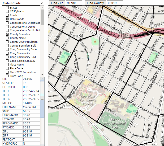 Uploading a layer -- Adding a Layer to a Project .. goto top Add a view or modify an existing view by uploading a layer. This feature enables you to upload any shapefile (points, lines, polygons). Add your own shapefile/data to an existing project to view/analyze your data with other existing layers/data. Analytical opportunities are unlimited! Adding Detailed Roads. The detailed roads layer included in the project is for Fairfax County, VA. Detailed (intersection to intersection) roads layers are organized county by county. Detailed road layers can be added to a project; theses shapefiles are available for any county. The following example illustrates adding Loudoun County, VA (adjacent to Fairfax County) roads. Adding 2020 TIGER detailed roads ("edges") for a county Step 1. Extract the Loudoon County, VA (51107) edges shapefile to c:\vdauploads .. suggested empty folder name Step 2. Delete all unzipped files in c:\vdauploads except these: tl_2020_51107_edges.shp tl_2020_51107_edges.shx tl_2020_51107_edges.dbf Step 3. Develop the INI file Copy the 11 lines below, paste into Notepad (any text editor) and save as c:\vdauploads\tl_2020_51107_edges.shp.ini Active=YES Caption=51107 Roads CodePage=932 CS.EPSG=4269 Ground=OnDem Label.Alignment=FOLLOW Label.Color=$10101 Label.Field=FULLNAME Label.OutlineWidth=2 Query=roadFLG='Y' Visible=YES.. the spelling/characters used in file names must match exactly. .. the Loudoun County roads (edges) shapefile has state county code 51107 .. consider choosing a different county Step 4. Zip (for example using Winzip) these four files to the new file c:\vdauploads\tl_2020_51107_roads.zip Step 5. With VDA running, use File>Upload Layer from the Main Menu bar to start the upload. The upload form appears: 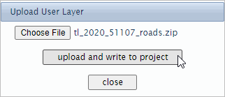 The above view shows that the user chose the file c:\vdauploads\tl_2020_51107_roads.zip The final step is to click the "upload and write to project" button .. a zip file of this zize may require a few secconds to complete; wait for a message and do not click upload again Viewing/Using Results: The following graphic shows a pan/drag view of the Leesburg area in Loudoun County. The 51107 (state county FIPS code for Loudoun County) Roads layer is made the Active layer. The road segment at the pointer was clicked; the Profile panel (lower left) is populated with attributes of that street segment. 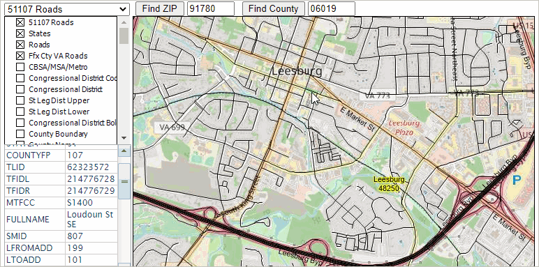 Step 6. Optionally save the updated project with a new name Add a Variation of an Existing Layer: The project already has a State Legislative Districts Upper layer. But you can add another layer that has a different map view: only Virginia districts (pick any state) with bolded black boundaries. Step 1. Extract the VA SLDU shapefile to c:\vdauploads .. suggested empty folder name Step 2. Delete all unzipped files in c:\vdauploads except these: cb_2020_51_sldu_500k.shp cb_2020_51_sldu_500k.shx cb_2020_51_sldu_500k.dbf Step 3. Develop the INI file Copy the 18 lines below, paste into Notepad (any text editor) and save as c:\vdauploads\cb_2020_51_sldu_500k.shp.ini Active=YES Active=YES Area.OutlineColor=$10101 Area.OutlineWidth=70 Area.Pattern=TRANSPARENT Area.SmartSize=16 Caption=VA SLDU CodePage=1252 CS.EPSG=4269 Ground=OnDem IgnoreShapeParams=YES Label.Alignment=CENTER Label.Field=SLDUST Label.OutlineWidth=2 Label.Position=MIDDLECENTER Name=cb_2020_51_sldu_500k OutCodePage=1252 Path=cb_2020_51_sldu_500k.shp Visible=YES.. the spelling/characters used in file names must match exactly. Step 4. Zip (for example using Winzip) these four files to the new file c:\vdauploads\cb_2020_51_sldu_500k.zip Step 5. With VDA running, use File>Upload Layer from the Main Menu bar to start the upload. The upload form appears: 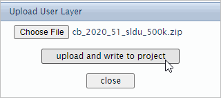 The above view shows that the user chose the file c:\vdauploads\cb_2020_51_sldu_500k.zip The final step is to click the "upload and wrtie to project" button .. wait for a message and do not click upload again Close the upload form when done. The view is shown below. 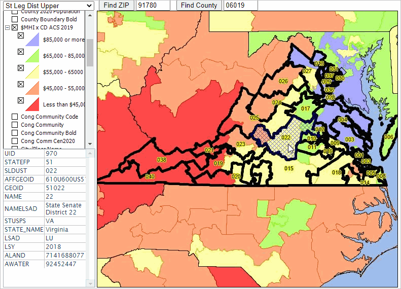 Step 6. Optionally save the updated project with a new name Table/Query Operations -- Build/Use Interactive Tables .. goto top .. build custom interactive tables .. and much more. The Table/Query feature enables viewing/processing the attribute data (e.g., demographics) for a selected layer (e.g., congressional districts) in a tabular/grid form. This feature enables the user to do these things: • view all fields of the selected layer in a tabular form .. or custom computed fields. • sort tabular data in grid on any column/field or combinations. • perform a query on tabular data/grid to view only selected rows (geographic objects). • click a row in grid to select that item then click "click geography row to display" .. Map Window refreshes with zoom to that geography. • output data in CSV or other format. Using Table/Query • to start Table/Query, click the Table/Query button below the Map Window at right (see graphic). • with the full Map Window displayed, clicking the Table/Query toggle button splits what was the Map Window. .. it becomes a split Map Window and Table Grid as shown below. • the Table/Query button is a toggle operation; click it again and the grid is removed. Congressional districts are used in the following example. The first step is select the "active layer" to the preferred congressional district layer. With VDA running, select the layer name "$MHI x CD ACS 2019" in the top left dropdown. Then click the Table/Query button below the table at right. Follow these steps to get the view shown below: 1 - set selected layers on and off 2 - enter in the SQL Fiter: select uid, geoid, totpop, medhhinc, medfaminc, medhsgval, medrent where geoid like '48%' 3 - enter in the Sort box: medhhinc desc 4 - click the query button. with the table ranked on medias household income ($MHI), see that CD 4803 has the higest $MHI. 5 - click that row in the table, it turns blue (the selected CD) 6 - click the red button below the table to zoom to that area in the map window. 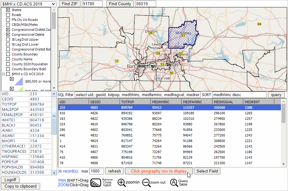 Using the Table/Query Query Operations • SQL Filter .. use a combination of fields and conditions based fields in Active Layer .. use parentheses and nested conditions. .. criteria value set in right edit box. .. click query button to perform filter operation on grid. Refreshing the Table Content After a query has been performed, only those records meeting the criteria appear in the grid. To reset/refresh the grid, so that it shows all records/rows, use the query UID > 0 .. The UID is the "unique identifier for current shape/geographic object". .. The UID appears as the leftmost column in the grid. The UID is the sequential number of the row in the file. Copying Rows from Grid for External Use To copy rows from the grid (click on one row or multi-select), right click the blue highlighted area, copying to clipboard. Ctrl-V to paste in an open editor or worksheet in another program/application. To copy the header/field names, .. click an object in the Map Window, the profile appears in the Profile panel. .. click the copy to clipboard button below the panel. .. Ctrl-V paste into a spreadsheet. .. copy the first column cells and paste special>transpose into the first row of the spreadsheet. .. from the grid, select the rows of interest and Ctrl-V into cell A2 of the spreadsheet. Handling Text Fields with Lead-zeroes Many fields in layers are geography codes with lead zeroes. The lead zeroes need to be retained when pasting into a spreadsheet. To accomplish this, before proceeding as described above, follow these steps: .. select the cells that will hold the data you are going to paste. .. display the Home tab of the Excel ribbon. .. click the small icon at the lower-right corner of the Number group. .. Ctrl-V the rows copied to clipboard from grid. Examining Demographic Characteristics of a Census Block .. goto top Find a Census 2020 census block based on an address. View the block in a a map and view/analyze demographics for that block and other blocks, individually or grouped as an aggregate. Steps in this section make use of the Census2020A project and apply to California 2020 census blocks. These operations can be performed for any state and require uploading a layer (see about uploading a layer) for other states of interest. In the following examples, the same census block is used, located in the Encino, CA area. Characteristics of a Census Block - Option 1 .. the block geocode is known The census block geocode, unique identifier among all 8.1. million blocks, is a 15-character code. The block code of interest is 060371397052001 Steps: Start with a fresh rendering of the Census2020A project. Set the active layer to the CA Block Layer. Set these layers in the legend panel .. 2020 %Asian x Tract unchecked .. World by Country unchecked .. OpenStreetsMaps unchecked Click the Table/Query toggle button; the block layer grid populates. Set the One Item query to GEOID = 060371397052001 then click query button at right. .. wait for the grid to show just this one block. .. click that row (it turns blue) then click the button "click geography row to display" .. the map window refreshes; the select block is shown with crosshatch. .. the demographic profile is shown in the Profile Panel (lower left) .. scroll down to see the Census 2020 total population is 447 in the legend panel, click on these layers: .. CA Block Code .. CA Block Population. That completes this example. Examining How County Demographics are Changing: 2010 to 2020 .. goto top This section provides information on using VDA to analyze county demographic change. See related information at: County Demographic Trends -- Census 2010 - Census 2020 E-mail us for more information or call (888-364-7656). FAQ .. goto top How can I compare Census 2010 to Census 2020 tracts?
Use the "Census2020" project. That project includes national scope 2010 and 2020 boundaries and codes.
Support .. goto top • Participate in a Weekly Web Session. Get answers to your questions. See VDA in operation. • Participate in the Using GIS and GeoDemographics course. • Join the User Group to receive updates. • Send your question through the Contact Us form. • E-mail us with questions or comments. |
|
|