

|
|
Geography Demographic data from Census 2000 are tabulated for the types of geographic areas shown in the following graphic. This section summarizes some of the key geographic terms and definitions related to Census 2000. Understanding the definition and use of these geographic areas (for tabulation purposes) is key to knowing how to access what types of subject matter.Census 2000 Geographic Tabulation Areas 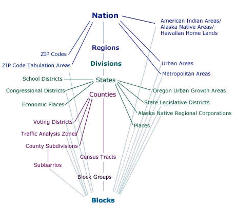
Geographic Areas & Census 2000. The following types of geographic areas are reviewed in this section.
State and county area names and codes used in Census 2000 tabulations are available in the Geographic Identification Code Scheme. State and county geocodes are often used with geocodes for smaller geographic areas (e.g., census tracts) as unique, short-hand, standardized identifiers. See U.S. by County Demographic Profile Database provided with and without shapefile structure. See the largest 100 counties based on Census 2000.
Metropolitan Areas Used for Census 2000 Tabulations Since Census 2000, a new set of official definitions for metropolitan statistical areas (MSAs) have been established by OMB. The initial Census 2000 MSA tabulations were based on the "1999 vintage" MSA definitions. In 2003, the new "2003 vintage" MSA definitions were established. The geographic definitions (as of June 30, 1999) used for tabulating Census 2000 metropolitan areas are available in these lists: • Metropolitan Areas and Components • Central Cities of Metropolitan Areas • New England County Metropolitan Areas and Components • Central Cities of New England County Metropolitan Areas Very limited scope Census 2000 demographic data have been tabulated by the Census Bureau for 2003 vintage MSAs. See 2003 Vintage Metropolitan Statistical Areas for more detailed information about current official metropolitan statistical areas.
Place and census designated place area names and codes used in Census 2000 tabulations are available in the Geographic Identification Code Scheme. Glossary references: Place Census designated place Incorporated city Consolidated city Largest 100 Cities based on Census 2000
School district geography for Census 2000 tabulations corresponds to the 1999-2000 school year. Learn more about accessing school district data via the School District Demographics Web page. There are some school district tabulation areas that are not officially Federal school districts. Major exceptions are in Hawaii and New York which have school district tabulation areas that have been specially defined and are not Federal public school districts. In addition, there are "balance of county" areas for earth surface areas not covered by any school district.
The census tract (averaging approximately 4,000 population) is the smallest unit of geography for which 'more extensive and more reliable' sample-based (short-form) data are available. It is not possible to aggregate census tract units to all other types of geographic tabulation areas (see graphic at top of this section). Philadelphia County, PA by census tract thematic map (median household income) with zoom view of tract 0010 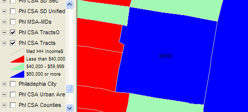
See Demographic Profile Database for information for the most widely used readily accessible census tract level data. These data may be easily integrated into shapefiles for mapping applications. See Census Tract Demographics for information about availability and use of census tract data and geography.
The census block group (averaging approximately 1,000 population) is the smallest unit of geography for which sample-based (short-form) data were tabulated. It is not possible to aggregate block group units to all other types of geographic tabulation areas (see graphic at top of this section). Philadelphia County, PA by census tract thematic map (median household income) with zoom view of tract 0010 -- with block group layer 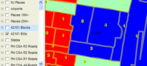
See Proximity Demographic Profile Database for information for the most widely used readily accessible block group level data. These data may be easily integrated into shapefiles for mapping applications.
The census block is smallest unit of geography for which Census 2000 data are tabulated (see graphic at top of this section). Census block data may be aggregated into any of the higher level geographic levels/areas. Census block data are only available for items covered on the complete count questionnaire. Philadelphia County, PA by census tract thematic map (median household income) with zoom view of tract 0010 -- with block group and block layers 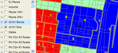
Zoom-in view of block group 2 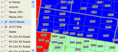
See Proximity Census Block Database for information for the most widely used readily accessible block level data. These data may be easily integrated into shapefiles for mapping applications.
ZIP Code Tabulation Areas (ZCTA) closely approximate U.S. Postal Service ZIP Code areas. It is not possible to aggregate ZCTA units to most other types of geographic tabulation areas (see graphic at top of this section). See Demographic Profile Database for information for the most widely used readily accessible ZCTA level data. These data may be easily integrated into shapefiles for mapping applications. See ZIP Code Demographics for information about availability and use of ZIP Code data and geography.
Urbanized Areas and Urban Clusters Classifications of urban and rural geography changed with Census 2000. Urbanized areas are similarly defined as with the 1990 Census but urban clusters are new. Urbanized areas and urban clusters combined are the "urban areas." Areas not classified as urban are rural. See the Urban/Rural GeoDemographics and Census 2000 for examples and more information about urban and rural classifications. The following four files list the Census 2000 UAs and UCs and their populations: an alphabetically-sorted list of UAs, an alphabetically-sorted list of UCs, a state-sorted list of UAs that shows the portion of the UA's population within the specified state, and a state-sorted list for UCs that extend into two or more states. The contents of the state-sorted UA and UC files are defined in the record layout. Census 2000 Urban/Rural Classifications The Census 2000 criteria are described at this URL: http://www.census.gov/geo/www/ua/ua_2k.html. Urban/Rural Classification Differences between 1990 and 2000 1990 Census. In the 1990 Census, "urban" refers to all territory, population, and housing units in urbanized areas and in places of 2,500 or more persons outside urbanized areas:
In 1990 Census sample data products, rural population and housing units are subdivided into "rural farm" and "rural nonfarm." "Rural farm" comprises all rural households and housing units on farms (places from which $1,000 or more of agricultural products were sold in 1989); "rural nonfarm" comprises the remaining rural. The urban and rural classification cuts across the other hierarchies; for example, there is generally both urban and rural territory within both metropolitan and nonmetropolitan areas. See this URL for a description of related historical data available from decennial censuses: Census 2000. For Census 2000, urban/rural criteria/classifications differ some from previous censuses. Urbanized areas are similarly defined as with the 1990 Census but urban clusters are new. Urbanized areas and urban clusters combined are the "urban areas." Areas not classified as urban are rural. |
|
|