|
Basic Operations |
  
|
| Show/Hide Hidden Text |
|
Basic Operations |
|
| Show/Hide Hidden Text |
The Proximity DMIGateway makes accessing more widely used demographic and economic data easier and faster. Are you a user of the Census Bureau FactFinder? A very useful resource, it is not easy to find what you are looking for – or even determine if the data that are needed exist. DMIGateway makes this much easier. Rather than building yet another database, DMIGateway gives you easy access to FactFinder data – as well as data from many other key demographic and economic data sources.
DMIGateway is a client-server operation. DMIGateway enables you to access data from many different servers, having different types of data and data access protocols, all through the standardized DMIGateway form. Only Internet acess and browser are required.
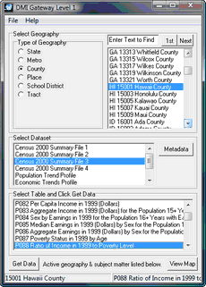
5 steps to accessing data
1 - Select a type of geography.
2 - Select a specific geographic area by dbl-clicking an area (row/line).
The upper right listbox population with the all-U.S. list of areas.
3 - Select a Dataset
When the type of geographic area is selected, datasets available for this type of geography are displayed in the second (from the top) listbox. Dbl-click the dataset of interest.
4 - Specific table or data object
For a selected dataset, the next listbox populates with tables, items or data objects available. Dbl-click the specific item of interest.
5 - Get Data
With all of the above selections set, click the Get Data button.
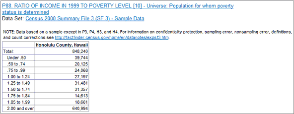
Upon clicking the Get Data button, DMIGateway passes a request to the relevant Web server with the specially formed URL content. The subject matter requested are displayed in an Internet Explorer browser window.
Your browser opens with a view of the selected data. With the default settings, the table presented below is displayed in your browser.
|
The geographic listbox populates in the following ways:
State 2-digit FIPS code followed by state name
MSA 5-digit FIPS CBSA code followed by the MSA name
County 2-digit FIPS state code, 3-digit FIPS County code, then county name
Place 2-digit FIPS state code, 5-digit FIPS Place code, then place name
School District 2-digit FIPS state code, 5-digit Federal school district code, then district name
Census tract 2-digit FIPS state code, 3-digit FIPS County code, 6-digit census tract code then county name
The county name is used with census tracts so that you can search for the first occurrence of a census tract in a specific county.
If you know the exact name of an area of interest, you do not need to use the scrollbar to locate the area of interest. Key the text to be located in the edit box above the geography listbox and click the find button. Make this entry short and exact. The entry needs to be case sensitive. The index is then located matching your text string and the selected item is highlighted. Dbl-click that row/line to complete the selection. If the row/line selected is not correct, click the find button again to search for the next occurrence. |
Page url: http://proximityone.com/dmigateway/guide/index.htm?operations.htm