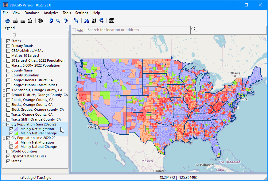
US1 GIS Project
The US1.GIS GIS project is included with all versions of VDA Desktop GIS.
It is the default GIS project and used at VDA Desktop GIS start-up.
10.31.23. Install the latest version of the US1* project filesets by unzipping with overwrite) https://proximityone.com/vdagis/us1_project_updates_103123.zip to c:\vdagis\1. This operation replaces the three *project* files us1.gis, us1_cacd47.gis and us1_world1.gis in the folder c:\vdagis\1.
US1.GIS Project Start-up View
The VDA Desktop GIS default start-up view is shown below. This view shows patterns of population change by county for the period 2020 to 2022. Color patterns in the legend at left of map show counties gaining and losing population and why the change occurred (migration vs natural increase). See more about examining county population trends.

Layers in US1.GIS Project
States
cb_2020_us_state_so51.shp18
Primary Roads
tl_2022_us_primaryroads.shp21
CBSAs/Metros/MSAs
cb_2020_us_cbsa_500kc
Metros 10 Largest
cb_2020_us_cbsa_500ka
50 Largest Cities, 2022 Population
cb_2020_us_place_500kpts
Places, 5,000+ 2022 Population
cb_2020_us_place_500ka
County Name
cb_2021_us_county_500kz
County Boundary
cb_2021_us_county_500kb
Congressional Districts CA
tl_rd22_us_cd118_clipped_ca
Congresssional Communities
cc20_us_012723cd_ca
K12 Schools, Orange County, CA
k12sch_06059
School Districts, Orange County, CA
sd_06059
Roads, Orange County, CA
tl_2022_06059_edges
Blocks, Orange County CA
cc_blk06059_2020pl
Block Groups, Orange county, CA
cb_2020_us_bg_500k_06059
Tracts, Orange County, CA
tracts21_itemset1_06059
Tracts $MHI Orange County, CA
tracts21_itemset1_06059
Cty Population Gain 2020-22
cb_2021_us_county_500knewct
Cty Population Loss 2020-22
cb_2021_us_county_500knewct
World Countries
World_Countries_2023
BaseLayer
OpenStreetsMaps
States1
cb_2017_us_state48
