CV XE GIS Home Page
Age-Gender Population Profile & Population Pyramid
    CD 4704 .. year: 2020 .. population group: 001 Total population

Age-gender characteristics are some the most widely used, and important, measures to help understand the socioeconomics of an area. Knowing about demographic characteristics of an area provides essential information for planning and analysis to meet policy, management and stakeholder needs.

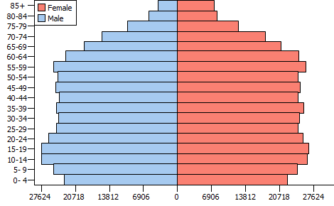
This document provides an age-gender grid/table for a selected geographic area. On the left is an age-gender tabular grid. These data are shown in the population pyramid graphic on the right.

Age Group Male Female Total CD 4704, 2020, Universe: 001 Total population
Population Pct Population Pct Population Pct
Age 0- 4 22,921 6.1 22,330 5.7 45,251 5.9
Age 5- 9 25,170 6.7 24,292 6.2 49,462 6.4
Age 10-14 27,500 7.3 26,361 6.7 53,861 7.0
Age 15-19 27,625 7.3 26,518 6.8 54,143 7.1
Age 20-24 26,101 6.9 25,410 6.5 51,511 6.7
Age 25-29 24,480 6.5 24,451 6.3 48,931 6.4
Age 30-34 24,106 6.4 24,758 6.3 48,864 6.4
Age 35-39 24,518 6.5 25,535 6.5 50,053 6.5
Age 40-44 23,940 6.3 24,367 6.2 48,307 6.3
Age 45-49 24,698 6.5 24,922 6.4 49,620 6.5
Age 50-54 24,212 6.4 24,475 6.3 48,687 6.3
Age 55-59 25,102 6.7 26,036 6.7 51,138 6.7
Age 60-64 22,703 6.0 24,523 6.3 47,226 6.2
Age 65-69 18,869 5.0 20,954 5.4 39,823 5.2
Age 70-74 15,356 4.1 17,777 4.6 33,133 4.3
Age 75-79 10,175 2.7 12,388 3.2 22,563 2.9
Age 80-84 5,851 1.6 8,047 2.1 13,898 1.8
Age 85+ 4,011 1.1 7,390 1.9 11,401 1.5
Total 377,338 100.0 390,534 100.0 767,872 100.0

This document has been generated using the ChartGraphics tool. The ChartGraphics tool may be accessed using only a web browser. The Chartgraphics tool operates on an age-gender dataset.

An important feature of the Chartgraphics tool is that it can be used with any age-gender dataset. Present options enable creating this page for the U.S., states, counties, congressional districts and congressional communities. More geographies may be added. Subject matter may be selected from Census 2000, 2010 and 2020 depending on type of geography. Subject matter may be selected from the decennial census, model-based population estimates, annual American Community Survey data among other sources.

ProximityOne uses these data to assist stakeholders with planning and evaluation analyses. We integrate these with other data to provide a broader range of insights. We also use these data to develop more current estimates and projections.

Tools and data used to develop this document and scope of content update periodically. Register to receive updates. E-mail us or call 800.364.7656 with questions about these and related data/data analyses.