|
|
|
What These Data Can Tell Us Geospatial Analysis Online Reference Maps Methodology School District Demographics Main Page |
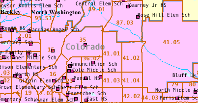
Colorado School District Demographics Colorado school district demographic comparative analysis profiles may be viewed using this Web page. These data, developed by Proximity, provide important information that can facilitate planning and evaluation. See New York State sample districts web page to see how school district demographics can be analyzed over time. Viewing Profiles. To view profiles for areas of interest, proceed with the following the three steps. If you click on display, step 3, as shown in the default state, comparative analysis profiles are generated for the Census 2000 districts of Denver County 1, Adams-Arapahoe 28J, and Adams County 14 school districts (see map). Source and Uses of the Data [goto top] Data made available via this Web page have been developed by Proximity for subject matter categories corresponding closely to the Census Bureau Census 2000 "demographic profiles." Why use these data? Because they represent the most widely used cross section of demographic data that can be used to assess the overall socioeconomic composition of an area. In addition, using this set of data items makes it easier to compare attributes of school districts with those of counties, communities, census tracts, ZIP code and other types of areas. The scope and content of the demographic profiles is described in the technical documentation located at http://www.census.gov/prod/cen2000/doc/ProfileTD.pdf. The technical documentation contains a glossary and related information that may be useful to users of data made available through this Web page -- the comparative analysis profiles. The Census Bureau developed the demographic profiles only for states, counties, places, and other selected governmental jurisdictions. The Census Bureau has not developed these subject matter summaries for smaller geographic areas such as census tracts and school districts. Relationship to Census 2000 School District Special Tabulation. The Census Bureau is in the process of developing the Census 2000 school district special tabulation (SDST 2000) under sponsorship of the U.S. Department of Education. The SDST 2000 data are expected to become available in the spring of 2003 (May). In contrast, the data demonstrated accessible via this Web page are available now. As the SDST 2000 data become available, the corresponding sections of the underlying Proximity database will be updated so that the Census 2000 data are identical. The comparative analysis format used in the display of the data for multiple school districts is a proprietary structure developed by Proximity. The comparative analysis capacity will be extended as the SDST 2000 data are released and Excel based files paralleling the comparative displays will be downloadable. The resources demonstrated through this Web page are transportable. That is, the html pages, software and databases may be placed on any Windows compatible HTTP server. Data dissemination plans for the NCES SDST 2000 data will be resident on the NCES server only, making it more difficult to integrate the SDST 2000 data with other data -- a key attribute of the evolving Proximity structure. Neither the Census Bureau nor the U.S. Department of Education will provide access to 1990 Census data beyond what now exists. This makes online access to 1990 Census school district demographics only available through Proximity developed resources. In addition, there is no capacity, other than through the Proximity resources, to access area-equivalent data for school districts enabling the comparison of characteristics in 1990 with characteristics in 2000. What These Data Can Tell Us [goto top] These data provide important information that can facilitate planning and evaluation. They help enable analysis of the following types of application areas. • Compare school district characteristics using a composite set of key indicators. • Assess 'state of education' -- educational attainment by school district. • Analyze attributes of the households that suggest different educational needs. • Assess special education needs using data on children with disabilities. • Assess size of certain populations of interest. • Examine patterns of labor force/employment infrastructure in relation to education. • Assess the need/demand for wide-ranging education-related programs and services. • Examine English language proficiency among school districts. • Analyze number of children in school systems for health and youth development. Geospatial Analysis [goto top] Data displayed in a tabular form can also be viewed in a geospatial analysis context. In the following maps, geographic information system (GIS) software is used to view a thematic map of English language proficiency for school districts in the Denver, Colorado area. The following graphic shows the Denver County 1, Adams-Arapahoe 28J, and Adams County 14 school districts. County boundaries are blue. Major roads are shown in gray. Schools are depicted as points/icons. The legend at the lower left shows data item DP2066 as a percent of DP2063. 26.9-percent of the population 5 years and older speak English language less than very well in Adams County 14 school district. View these data in the table via this Web page using the default geography selections and viewing the in the lower section (Language Spoken at Home) of Table 2. Adams County 14 school district has a value of that places the district in the top (5th interval). It is easy to reconstruct the data items used in the thematic display, zoom in or out to an area of interest, change colors and highlights, and present different related layers. 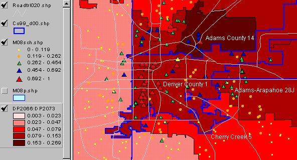
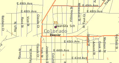
Schools are shown as points/icons on the map. In the following map, Swansea elementary school is highlighted in yellow. A tabular display of attributes of the school (2000-2001 school year) are shown in the panel at the left. Total enrollment by grade and Hispanic enrollment by grade are shown in the fields in the lower section of the table. This view demonstrates how the school level distribution of Hispanic enrollment (93 in grade 1) can be assessed relative to total enrollment (101 in grade 1) by grade. 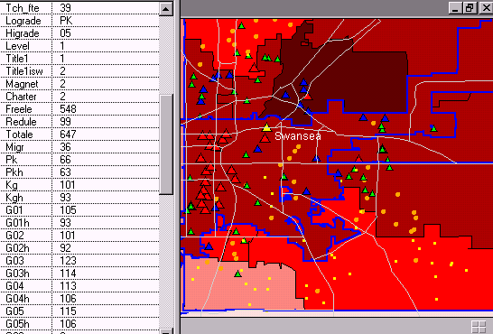
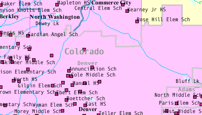
Online Reference Maps [goto top] Maps of school districts, in the context of counties, communities, census tracts, streets, schools, and other features may be viewed using the Census Bureau Web-based Factfinder (http://factfinder.census.gov). Getting the Maps, Step-by-Step. Here is a step-by-step summary describing how to get a map for districts of interest and see related geography.
Methodology [goto top] Demographic data for school districts have been developed by aggregating census block and census block group level data to corresponding school district geography. Data presented in Table 1, General Demographics, are derived from the Summary File 1 (SF1) complete-count data. SF1 data are summarized for the low level geography of census block. School districts may be defined as a unique set of census blocks. School districts boundaries, as used in Census 2000, do not split census blocks. Though tedious, development of the SF1 school district data from census blocks is straight-forward and not subject to any errors of estimation. Data presented in Tables 2-4 are derived from the Summary File 3 (SF3) sample-based estimates data. SF3 data are summarized for the low level geography of census block group. As shown in the above map, school districts do split census block group (BG) boundaries. School district summary data in Tables 2-4 is developed by aggregating BG summary data for the corresponding area. In those cases where a BG is split by the school district, the BG data are apportioned to the school district(s) splitting the BG. The allocation of the data is based on the portion of the BG in the school district as determined by the component census blocks. The allocation of the data is based on the total population, households, or housing units, depending on the specific subject matter. An error of estimation exists in all SF3 data at all geographic levels since the data are based on sample-based questionnaire data. In the case of the allocation of split BGs into respective school district area, additional error, albeit small, is also introduced. Terms of Use Data made accessible through this Web page are made available for subscriber use only and may not be used by non-subscribers for production or operational applications without further authorization. These data are provided for end use only and may not be redistributed. [goto top] |
|
|