Welcome

Contents
Welcome to ProximityOne CVGIS!
Answer questions as fast as you can think of them with ProximityOne CVGIS. .. at your fingertips ...
... learn about what else ...
What's happening ...
Join us in weekly Data Analytics Web sessions to discuss GIS and data analytics topics and questions you might have.
ProximityOne CVGIS is business intelligence software that helps you see and understand your data. • Fast Analytics .. Connect and visualize your data in seconds. • Ease of Use .. Anyone can analyze data with intuitive operations. Instant insight. • Big Data, Any Data .. From spreadsheets to databases, explore any data. • Smart Dashboards .. Combine multiple views of data for richer insight. • Update Automatically .. Fresh data with live connection to your data. • Share in Seconds .. Publish results with a few clicks. Share it live on the web and on any devices.
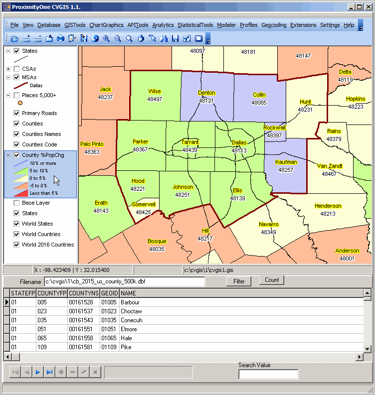
CVGIS Start-up View .. learn more about key features of CVGIS described below the graphic.
The CVGIS start-up view shows patterns of economic properity by neighborhood for the Dallas metro area. Learn more about using the powerful and easy-to-use GIS mapping tool in this Guide. Learn how you can use CVGIS to develop similar maps showing your data for your geography.
... view the whole world -- zoom-in to any part of it using the same CVGIS project. ... the world awaits.
• GIS .. Geographic Information System tools & ready-to-use applications .. mapping, geospatial analysis, geographic reference data. • Database .. tools to manage your data; structure, integrate, update, view • Worksheet .. create, use, publish worksheets; import/export Excel • Chartgraphics .. create population pyramids and other market analysis views .. create wide-ranging graphics • APITools .. access statistical data using APIs; save data in a form you can use. .. access geographic data using APIs. • Statistics .. create custom estimates using crosstabs with microdata .. perform statistical analyses; examine data relationships • Modeler .. create model-based estimates & projections .. assess impact of change on your situation • Profiles .. create comparative analysis profiles; link multi-sourced data into a form you can use. • Geocoding .. convert addresses to geocodes; assign census block codes; create point shapefiles. .. assign census block and other geocodes to your latitude-longitude data. • Utilities .. use zip/unzip, scripting, text editor and publishing tools.
-------------------- Updated: 12/29/2016
|