Relating Census Tracts & ZIP Code Areas

Contents
This section illustrates use of the GeoGateway tool to develop a map showing a Census 2010 census tracts layer and a ZIP Codes layer focused on one county. The same process may be applied to any county in the U.S. using the CV XE Viewer and all Levels. The same process can be applied at the state level (all tracts in the state and all ZIP Codes in the state).
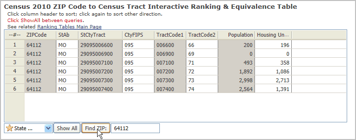
See corresponding interactive table relating all tracts to all ZIP codes -- http://proximityone.com/ziptractequiv.htm
Summary of Steps
File>Close and project or open coverage.
Start File>GeoGateway
Click the Apply button in listbox 1. Select Geographic Scope (this selects Missouri)
Census Tracts
Navigate/scroll down to Jackson County
dbl-click <MO 29095 Jackson County> item ... listbox 2. Select Shapefile re-populates
dbl click <Census Tracts> item ... two edit boxes below list box sections populate
Click Download; respond to messaging.
In the Add Layer to Project section
... select Shape Label as <GEOID10>
... select Label Outline Color as <White>
Click Add Layer
ZIP Codes
Click the Apply button in listbox 1. Select Geographic Scope (this selects Missouri)
dbl-click <MO 29000 Missouri> item ... listbox 2. Select Shapefile re-populates
dbl click <ZIP Code areas> item ... two edit boxes below list box sections populate
Click Download; respond to messaging.
In the Add Layer to Project section
... select Shape Label as <ZCTA5CE10>
... select Area Outline Color as <Red>
... select Area Outline Width as <50>
... select Label Outline Color as <Yellow>
Click Add Layer
Close GeoGateway
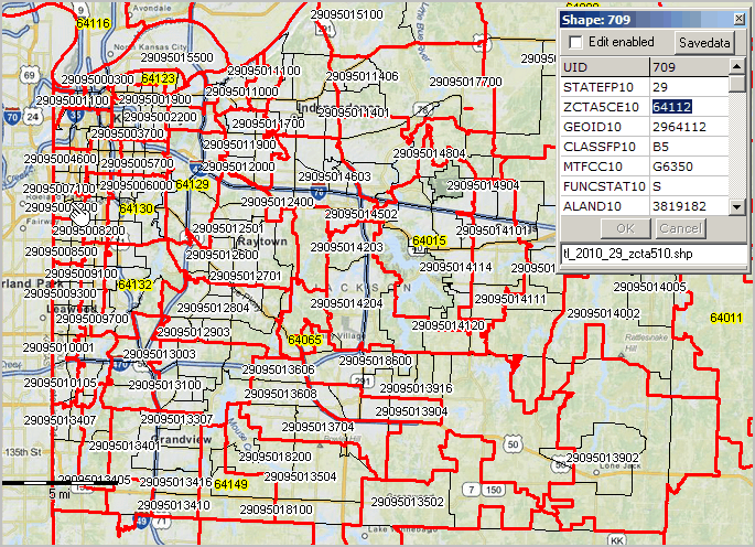
The view now looks similar to the graphic shown below ... Jackson County, MO by census tract and ZIP code area.
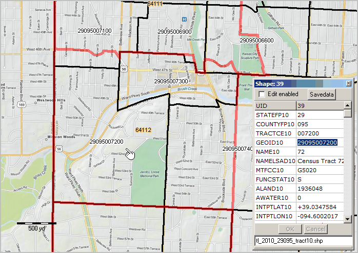
Navigate/Zoom to the location near the pointer in the above view ZIP code 64112, similar to view shown below.
ZIP 64112 (yellow background label), red boundary, intersects with tracts (white background labels)
29-095-007100, 29-095-007200 (dominant by pointer), 29-095-007300, 29-095-007400 and
two small parts of 29-095-006900 and 29-095-006600.
Optionally use Layer Editor to adjust boundary settings.
By further zooming, all street segment boundaries can be easily identified.
These relationships are shown in a tabular format in the table at http://proximityone.com/ziptractequiv.htm.