Web Map Servers

Contents
Web Map Servers (WMS) provide optional data layers. Some Web Map Servers are operated by others and may not be available. Most WMS resources include many layers. WMS resources require Internet connectivity. Note that many other CVXE map and geospatial operations do not require Internet.
Comparing WMS Layers to Shapefile/Vector Layers
Advantages of WMS
| • | Web-sourced, not loaded onto local hard drive |
| • | Wide ranging layers typically available from one WMS |
| • | Census WMS provide extensive selection of geographic layer types from a single source (rather than opening many shapefiles) |
| • | Census WMS provide national scope geography combined with smallest geographic area drill-down |
Disadvantages of WMS
| • | Inability to control attributes of layers (server side controlled) |
| • | Raster graphics typically provide poor presentation quality |
| • | Rough appearance of boundary lines and labels may limit effective interpretation |
| • | Labeling of geographic objects is typically awkward |
| • | Web-sourced, not local and thus requires Internet |
Availability
Levels Viewer, 1, 2, 3
Usage
File>Open>Favorites
After opening a WMS resource, shapefile layers may be added.
Related Information
http://proximityone.com/cvxe_wms.htm
Census TIGERweb WMS URLs:
Five TIGERWeb WMS layersets are available: (click link to view layers and attributes)
| • | Current: http://tigerweb.geo.census.gov/ArcGIS/services/tigerWMS_Current/MapServer/WMSServer |
| • | ACS12: http://tigerweb.geo.census.gov/ArcGIS/services/tigerWMS_ACS2012/MapServer/WMSServer |
| • | ACS11: http://tigerweb.geo.census.gov/ArcGIS/services/tigerWMS_ACS2011/MapServer/WMSServer |
| • | Census 2010: http://tigerweb.geo.census.gov/ArcGIS/services/tigerWMS_Census2010/MapServer/WMSServer |
| • | Physical Features: http://tigerweb.geo.census.gov/ArcGIS/services/tigerWMS_PhysicalFeatures/MapServer/WMSServer |
Illustrative Views
Upon selecting File>Open>Favorites, the Favorites dialog form opens. WMS layers may be selected from the Favorites list. The view below may not be the current version. Click Reset button to view the up-to-date list of layer sources.
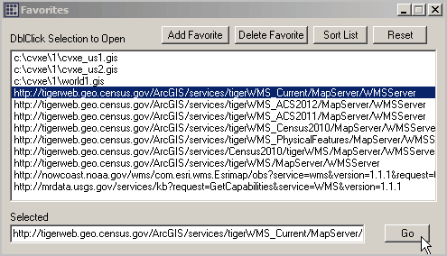
Dbl-click a selection and it appears in the Selected edit box. Click Go to open this WMS as a layer.
Perform these steps to examine how this WMS can be used:
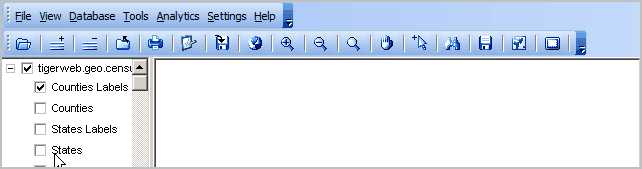
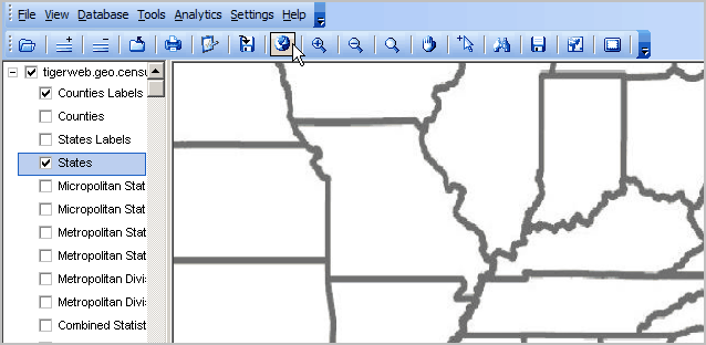
1. Click States in legend panel (see above).
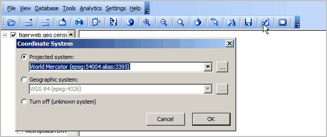
2. Select the World Mercator projection (see below)
3. Click the Full Extent button
4. Zoom to the view shown below
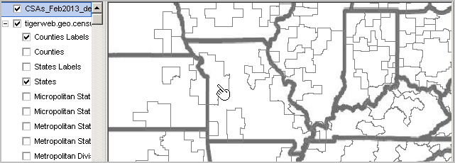
5. Optionally add shapefiles
In the view below, the Combined Statistical Areas 2013 vintage has been added. Acquire this shapefile using GetGeodata.
6. Optionally save the project.
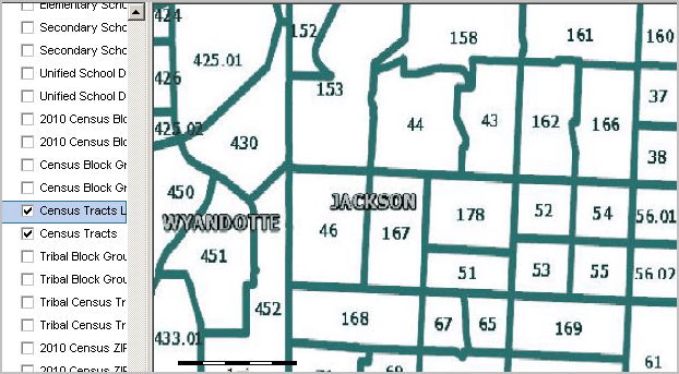
7. Selecting Census Tract Layer with drill-down into Jackson County MO