|
Maps & Locating Tracts |
  
|
|
Maps & Locating Tracts |
|
Locating tracts of interest in a state file. You might have interest in only a portion of a state, such as a county or metropolitan area. Use the geographic identifier codes to select only those parts of the state file of interest in such cases.
County names are not included in the census tract demographics files. To locate census tracts in a set of counties of interest, you need to know the county code for the county(s). The county code field in the database is shown as FIPS County Code. One way to get the FIPS County Code (a three digit code with leading zeroes) is to use the code-name equivalency list located at http://www.census.gov/geo/tigerline/apendx_a.txt.
Similarly, metropolitan area names are not included in the files. However, the MSACMSA, CMSA, PMSA, or NECMA code(s) can be used to select tracts in metropolitan statistical areas of interest. Get these code(s) for your areas of interest from the list provided at http://www.census.gov/population/estimates/metro-city/a99mfips.txt.
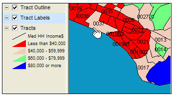
Viewing census tract boundaries. Given that you have a set of census tracts codes, possibly a list such as shown in Figure 3, there are several map options that can be used to view where these tracts are located.
| 1. | Use the supplemental census tract geodemographic map files, available from Proximity, to display thematic and reference maps. See your city or other boundaries superimposed on the tract boundaries. Draw maps flexibly to suit your geographic focus interests. |
| 2. | The CommunityViewer software and Hawaii project file referenced above are used to develop this zoom-in view of tracts 37 and 38 used in the spreadsheet. Street overlay and other features could be added. |
| 3. | An overview of Census Bureau map resources is located here: http://www.census.gov/geo/www/maps/CP_MapProducts.htm |
| 4. | If you have mapping software, you can also download files from here: http://www.census.gov/geo/www/cob/index.html |
| 5. | For hard copy maps, you can use these census tract outline maps: http://ftp2.census.gov/plmap/pl_trt/ with more information provided here: http://www.census.gov/geo/www/maps/descriptwindows/outline.htm |
Page url: http://proximityone.com/tracts/guide/index.htm?maps__locating_tracts.htm