Database Operations
Database operations are reviewed in this section. This section is focused on use of dBase files supported by VDA Desktop GIS. Database operations in VDA Desktop GIS are of two, related, types. Many data development, integration and management/use applications of dBase files are independent of mapping applications. Tools reviewed in this section focus on those, non-mapping, applications. The second role for dBase files is as a component of a shapefile which are widely used in GIS, mapping applications and geospatial analysis.
Shapefiles are one of the most widely used GIS formats used by the VDA Desktop GIS software. All GIS software support used of shapefiles, some more than others. Shapefiles make used of dBase files as one of their core, key component files.
dBase is a file structure developed in the 1980s and was one of the first successful database management systems for microcomputers. dBase file structure is normally referenced with a .dbf extension and sometimes referred to as a "dbf" file. The simplicity of the dBase file structure, public domain architecture, ease of conversion to other formats/file structures, and widespread use in shapefiles used in GIS applications are among features that make dBase files continue to be popular.
Shapefiles are comprised of minimally three files: geometry file (.shp), dBase file (.dbf), index file (.shx) and normally a fourth file, the projection file (.prj). The index file relates objects in the .shp file to records in the .dbf file. The projection file is used to define the projection used for the shapefile.
This section makes use of the shapefile c:\cvxe\1\gz_2010_us_050_00_500k.shp, developed by the Census Bureau, for illustrative applications. This shapefile is the Census 2010 U.S. by county shapefile with "smoothed" vertices. The geography is this shapefile is for use with data tabulated for counties as of Census 2010. This shapefile is included in the VDA Desktop GIS installation package. The complete shapefile includes these files:
| • | c:\cvxe\1\gz_2010_us_050_00_500k.shp |
| • | c:\cvxe\1\gz_2010_us_050_00_500k.dbf |
| • | c:\cvxe\1\gz_2010_us_050_00_500k.shx |
| • | c:\cvxe\1\gz_2010_us_050_00_500k.prj |
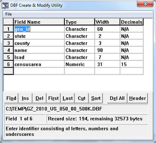
The original Census-sourced dBase file is opened using dBCreate (discussed below):

This file has 6 files shown in the grid with associated attributes. The field "censusarea" is the area in square miles. The attributes of this field (numeric 31 characters wide, 15 decimal characters) is not a valid specification, so the attributes of the field are changed to is numeric 15 width with 5 decimal positions.
The File>Save operation is used and the dBCreate form is closed.
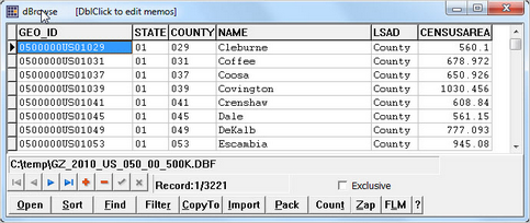
To view the content of this file, the file is opened with dBrowse (discussed below):

Use of this file is further discussed in the operations described in this section.
Availability
Levels 2, 3; specific operations vary by Level
Operations
| • | dBCreate --Create new database structure |
| • | dBMerge -- Selectively merge database file fields using flexible match key |
| • | dBrowse -- View/modify database files; sort; perform queries; import/export |
| • | dBTools -- Create structure; rename; zap |
| • | dBGrid -- Load file to graid; convert XLS file to DBF structure |
