Census Block Demographics

Contents
Census Blocks are the smallest geographic area for which the Census Bureau develops polygon shapefiles and tabulates demographic data. Census blocks are defined for each decennial census and may be updated as to block geocode and geographic extent from census to census. In general, demographic data are tabulated at the census block level only from the decennial census. There are more than 8 million Census 2020 census blocks covering the U.S. wall-to-wall. This section is focused on Census 2020 census blocks using iVDA.
iVDA is one part of a broader VDA GIS resource framework. See more about VDA GIS.
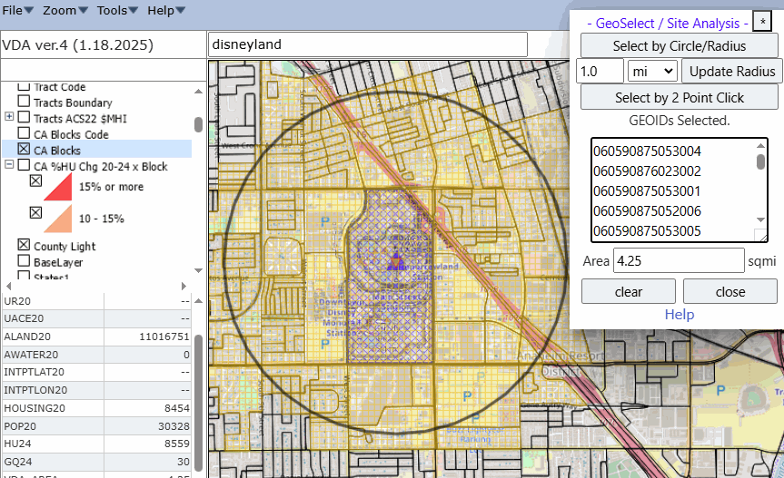
Disneyland 1-mile Circular SiteAnalysis
choose any California location
Start: https://proximityone.com/vdagis_discovery/index.html?blocks.htm
Enter disneyland in searchbar; press enter
Select layer CA Blocks in Legend Panel; blocks show
Select Tools>GeoSelect/SiteAnalysis; form displays
Click Select by Circle/Radius on smaller form
Click marker; one mile radius shows
View blocks; block geoids show; e.g. 06 059 087505 3004
View SiteProfile, lower left, housing 2020 8,454 to 2024 8,559
Try the above sequence with your own address.
Visual Data Analytics Web GIS
iVDA is presented below in an interactive mapping window .. watch video
Below is a static graphic example of using iVDA as described above.