.. develop insights into patterns, change and trends
.. geographic, demographic, economic characteristics
.. gateway to the Federal Statistical System
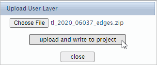
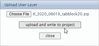
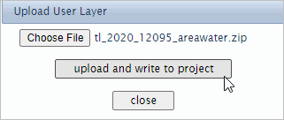
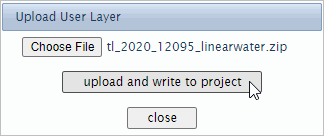
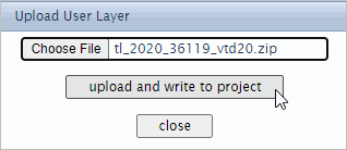
.. integrate your data; add your GIS projects
VDA Situation & Outlook Project
Start-up view .. click graphic for larger view
.. Texas is clicked in map
.. displays Census 2020 demographic profile in lower left panel
.. see more about the S&O project below
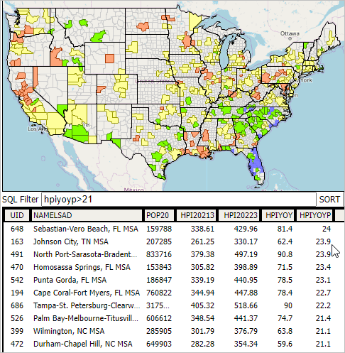
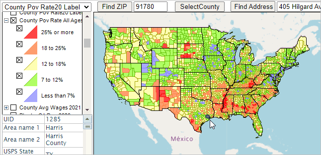
Percent Population Change 2010-2020 by County
Upcoming & Recent Developments
You are invited ..
Join us in the every Thursday Web Sessions GeoSpatial Analytics
a forum focused on GIS, geography, situation & outlook
02.05.22
Situation & Outlook Project Update
Congressional Communities update
.. use VDA tools to view/analyze these data in maps or tabular form
.. create your own custom interactive tables
.. see details soon
Geography and TIGER/DMD sections updated/expanded
These sections also show in the menu.
11.18.21
VDA Web GIS Situation & Outlook Update
U.S. by Tract HUD Qualified Census Tract analytics enabled
U.S. by Tract FFIEC Low & Moderate Income analytics enabled
11.17.21
New feature
Dynamic computation of shape/object geographic area
VDA User Guide (this document) restructured; device independent
10.05.21
New features Project Editor - modify map views; create new projects
Introductory Notes About VDA
The initial Census 2020 demographics by census block and
higher level geography became available August 12, 2021. See details.
Use the Visual Data Analytics VDA Web GIS to access/use these data optionally with your data .. we invite you to join in!
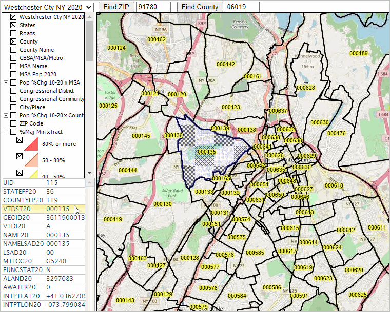
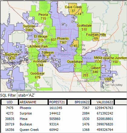
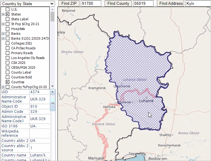
Quick Click Comparative Analysis County Profile .. goto top
.. easy to use and powerful capabilities
.. a click or two away from a profile for any county:
- login and select the "Situation & Outlook" project.
- above the Map Window, enter the state+county FIPS code (stcty) for county of interest.
- click Find County button.
.. the default stcty code is 06019 (Fresno County, CA).
- the county highlights in Map Window; the profile shows in the lower left panel.
optionally change these layer settings in Legend Panel:
- uncheck "County %PopChg 2010-2020"
- uncheck "World by Country"
- check on "OpenStreetMaps Tiles"
- click the copy-to-clipboard button below the profile panel.
- open the S&O County XLS template.
.. the XLS template file initially shows data for the default area -- Fresno County
- orienting .. note that the Census 2010 total population for Fresno County (cell C20) is 930,450.
.. paste (Ctrl-V> into cell K1 .. adding the copy-to-clipboard data to the view; replacing the default data.
.. data from profile panel show in Col 3 with descriptive stubs
- 30 subject matter items from Census 2010
- same set of items from Census 2020
- set of richer demographics from ACS 2019
- model-based estimates & projections.
.. see more about County Trends
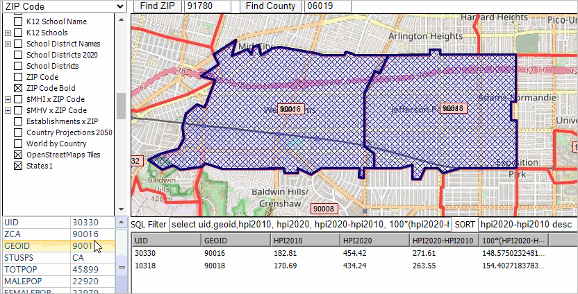
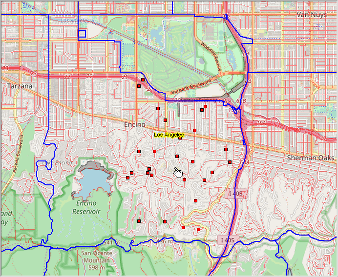
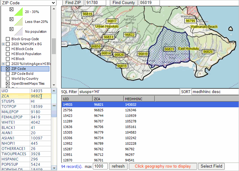
Quick Click Comparative Analysis ZIP Profile .. goto top
.. easy to use and powerful capabilities
.. a click or two away from a profile for any ZIP Code:
- login and select the "Situation & Outlook" project.
- above the Map Window, enter the 5-digit ZIP code for a ZIP code of interest.
the default ZIP code is 91780 located in Los Angeles County, CA.
.. see details
about this ZIP Code
.. the FHFA HPI is computed for approximately 19,000 ZIP codes (of approximately 33,000)
the HPI values are zero for non-computed areas
.. the ZIP code area highlights in Map Window; the profile shows in the lower left panel.
optionally change these layer settings in Legend Panel:
- uncheck "County %PopChg 2010-2020"
- uncheck "World by Country"
- check on "OpenStreetMaps Tiles"
.. click the copy-to-clipboard button below the profile panel.
.. open the S&O ZIP Code XLS template.
- the XLS template file initially shows data for the default area -- ZIP 91780
note that the ACS 2019 total population for this ZIP (cell C6) is 35,133.
.. paste (Ctrl-V> into cell K1 .. adding the copy-to-clipboard data to the view; replacing the default data.
.. data from profile panel show in Col 3 with descriptive stubs
- set of richer demographics from ACS 2019
- annual FHFA HPI estimates 2010-2020 (base 2000=100).
.. see more about HPI by ZIP Code
The World in Constant Change .. goto top
The world is in constant change. Keeping up with knowing about the where, what, how and how much of change is and might occur can be challenging.
"Knowing" is important for many reasons from understanding opportunities that may exist to learning how change might impact us.
Visual analysis using interactive mapping is often the most effective and fastest way to answer many types of geodemographic questions.
Communicating and collaborating with others can produce better results using maps than using tabular data alone.
Viewing/Analyzing Data from Census 2010, Census 2020 & ACS .. goto top
Use the VDA3 ready-to-use projects to view/analyze data from
Census 2010,
Census 2020,
American Community Survey down to the
census block/block group level of detail. Integrate your geography and data.
GeoSpatial Analytics group - a forum focused on GIS, geography, situation & outlook
.. Request to join
.. Registered participants click here to access forum.
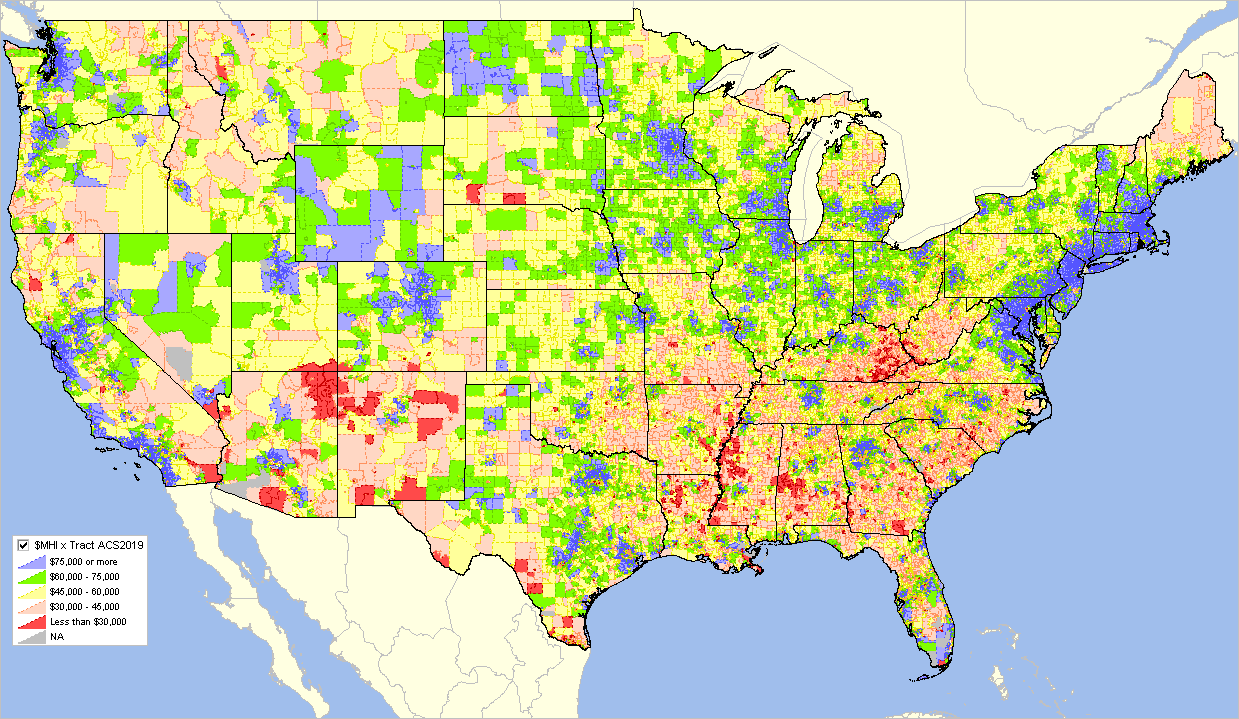
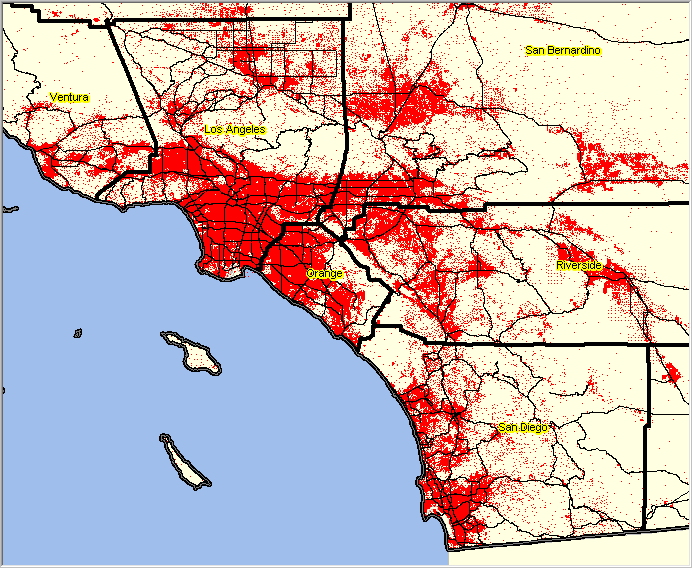
VDA Start-up View .. goto top
The following graphic shows the VDA start-up view using the "Census 2020" project. VDA operates with most browsers.
Start VDA to dynamically see the view shown below.
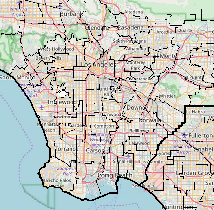
The Census 2020 start-up view is focused on southern California.
This view shows patterns of economic prosperity -- median household income ($MHI)
by census tract. Easily, flexibly and quickly shift the view to your area of interest.
.. click graphic for larger view.
About VDA, Credits, Using this Document .. goto top
This document provides an overview of the
VDA Web GIS and instructions on its use.
VDA has been developed by Warren Glimpse/ProximityOne/Alexandria, VA USA and Takashi Hamilton/Tsukasa/Osaka, Japan.
All that is required to use VDA is a Web browser. iOS and Android versions are
supported. VDA uses the same core structure as the Windows desktop
VDA Desktop.
VDA3 is the premier version of VDA, offering to manage your own GIS projects, securely and efficently.
What's Ahead & Happening .. goto top
• Project Editor feature for Level 3 users; edit your project right down to a label color
• VDA Web GIS now an integral part of the Certificate in Data Analytics
• VDA Web GIS "every Thursday" training & support VDA Data Analytics Web Session
• New and updated "Base Projects"; new structures and refreshed data.
Visual Data Analytics VDA Web GIS.
VDA Web GIS is a learning resource, a tool that you can use for interactive mapping and geospatial analysis using only Internet and a browser.
VDA is set apart from related tools due to the scope and style of accessing data for wide-ranging geography
and frequently updated demographic-economic subject matter data.
Use our unique combination of Federal statistical data with proprietary current estimates and projections.
There is nothing to install. Use VDA anywhere. VDA is available in these forms:
• Web-based interactive access using a browser and HTML .. get started now, click this link.
• Installed on your hosted server for your private (e.g., organization-wide) use.
• Provided as a complete turnkey package for use on your site with related GIS project developer tools.
.. integrate your own data.
The Visual Data Analytics (VDA) Geographic Information System (GIS) is a multi-dimensional set of software, data and methodoligies
designed to provide mapping, geospatial processing and analysis, data development and maintenance to meet wide-ranging learning, policy analysis
and business intelligence needs.
Learn more about Geographic Information Systems.
VDA Desktop GIS and VDA Web GIS have similar features that can be used separately or together.
Each is a decision-making information resource designed to help stakeholders create and apply insight.
VDA Web GIS is accessed/used with only a Web browser;
nothing to install; GIS experience not required.
VDA Desktop GIS is installed on a Windows computer
and provides a broader range of capabilities compared to VDA Web GIS.
We have expanded the scope of VDA tools data development resources as summarized below.
These harmonized tools now meet all user platforms and devices.
VDA GIS resources have been developed and are maintained by Warren Glimpse, ProximityOne (Alexandria, VA)
and Takashi Hamilton, Tsukasa Consulting (Osaka, Japan).
1. Open VDA GIS Web (OVDAW) Start OVDAW About OVDAW
.. similar to VDAW
- fewer features than VDAW
- provides only access to “Base” (comprehensive, frequently updated)
.. no login, no fee, nothing to install
.. see OVDAW step by step application examples
2. VDA Desktop GIS
.. the most powerful, capable tool
.. operates on Windows PC platform
.. for all users but specifically for those processing confidential data on a specific computer
.. more information
3. CV XE GIS
.. similar to VDA Desktop GIS
.. operates on Windows PC platform
.. for all users but specifically for those processing confidential data on a specific computer
.. more information
4. VDA Desktop GIS via RDS
.. the most powerful, capable tool
.. run online via Remote Desktop Service
.. operates using most platforms and devices (including Mac, iOS)
.. very fast even with Internet interface
.. enables access to existing VDAW web-based
.. more information
5. Demographic-Economic Data Explorer (DEDE
.. create custom GIS friendly data files
.. choose from multi-sourced Federal Statistical System
.. use your data with GIS tools, your own software, Excel, or other tools
Open VDA Web GIS (OVDAW) is an alternative version of VDA Web GIS (VDAW) that does not require login. Click here to start OVDAW.
OVDAW opens the VDA Base GIS project.
See this more updated section focused on using OVDAW.
OVDAW Start-up View/Orientation & Getting Started
The start-up view shows the U.S. contiguous states.
Counties and States layers are checked-on in the legend panel at left.
.. this enables those layers to be shown in the map window.
Find (navigate to) an address or area of interest ..
.. enter a ZIP code, address or location in search bar and press .
How OVDAW operation/features differs from VDA Web GIS.
.. the Base GIS project is available using OVDAW, VDAW, VDAD.
.. extended features on the top menu bar are not available using OVDAW.
.. custom structured profiles are not available with OVDAW.
.. layers cannot be edited using OVDAW.
Selecting and Using the Active Layer
The layer (as layers shown in the Legend Panel) is set by selecting a layer from the upper left dropdown.
.. the default setting is census tracts -- "Tracts $MHI"
When you click on a shape/object in the map, a profile is shown in lower left, for the Active Layer object.
.. to view attributes and shape highlight for a Congressional Community (CC), you would:
1) make Congressional Communities as the Active Layer, 2) click in the map to highlight/select a CC.
.. the selected Active Layer stays on/selected until it is changed or VDA Web Base/browser is closed/session ended.
Illustrative applications
Two steps to locate/map/view a census tract based on address
.. enter address, maybe only enter ZIP 85258 to illustrate (in Scottsdale, AZ)
.. at refreshed zoom view, click blue marker on map
.. tract boundary appears; see tract code & demographics in profile below map
.. the tract code is 04013216807
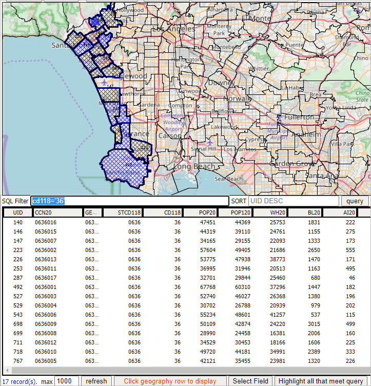
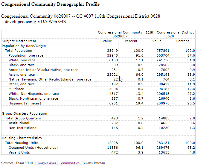
Where is my Congressional Community and what are its attributes?
Locate/map/view a Congressional Community (CC) based on address
.. make active layer Congressional Communities (select from upper left dropdown)
.. enter address, maybe only enter 85258 to illustrate (ZIP code in Scottsdale, AZ)
.. at refreshed zoom view, click blue marker on map
.. CC boundary appears; see CC code & demographics in profile below map
.. the CC code 0401010 .. CD118 AZ 01 010
This section provides basic getting started information. Although VDA requires only a browser and can be used with most any device,
it is suggested that a desktop computer be used for the best experience. To experience all features of VDA it is suggested that the the browser setting allows popups.
Login Form
When VDA starts (click this link to start VDA), enter your userid and password in the login screen.
.
Registering as a New User
To register as a new user click "Signup" on the Login form (above), the following registration information appears.
the following is just an example. Start VDA to signup and perform this step.
SignUp to use VDA ...
1) Add your name and email address below. Then click OK.
2) You will receive an e-mail with your initial password.
3) You can use the VDA Login form and start VDA.
See more information here
user name
email address
You will receive an email confirming your account has been created and providing an initial password.
You may then start VDA and login with your userid and password.
• your userid is your e-mail address
• your password is initially the one sent to you by VDA admin
• you can optionally change your password on the login form.
Signing up to use VDA provides Level 1 access. Note that Level 1 users do not have access to all features
and that a 10-minute automatic logoff will occur during sessions. Optionally login and resume VDA use.
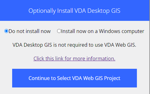
After VDA Login .. optional VDA Desktop GIS installation .. goto top
After logged in, the VDA Desktop may be installed.
After Optional VDA Desktop installation .. goto top
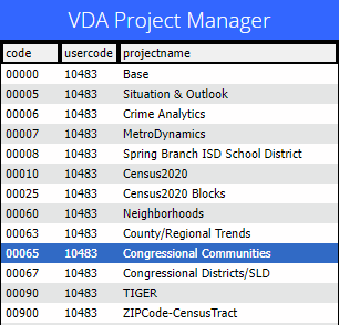
Next, the Project selection form appears.
Select from your authorized projects, immediately starting that project,
• to select a project, click on the project name; it turns blue.
• then click the Select project button.
• VDA starts and the selected project opens.
Which project to use?
• see more information about available projects.
Changing Password
After login, change your password on the VDA User Profile form (see above) by clicking the Change Password button at the bottom of the form.
A new form appears where you can enter your new password.
Recommended Getting Started Steps .. tutorials/examples
Start using the "Situation & Outlook" project and follow these steps.
Using the Find ZIP Code feature
• Enter a ZIP code in the Find ZIP Code edit box above the Map Window, then click the Find ZIP button.
• The Map Window refreshes showing a zoom to the selected ZIP code and displayed the ZIP as crosshatched.
.. this can be a useful tool to locate an area of interest.
• If you use ZIP code 91780 (try it now), the Map Window refreshes to an area in Los Angeles.
• As the ZIP code query is performed, a demographic-economic profile is diaplayed in the Profile Panel (lower left).
.. see that the ZIP Code (ZCA) shows value 91780 and the total population 35,133.
Using the Find Address feature
• Enter an address in the Find Address edit box above the Map Window, then click the Find Address button.
• The Map Window refreshes showing a zoom to the selected ZIP code and displayed the ZIP as crosshatched.
.. this can be a useful tool view the location of an address of interest.
.. the default address "405 Hilgard Avenue 90095" is the UCLA address in Los Angeles.
.. use of this partial address illustrates that an exact addrees or address form is not required.
• This Find Address feature is one of several methods of finding/viewing an address.
What/Where is my Congressional Community?
• This example introduces the Select Layer feature and Active Layer concept.
• The Congressional Communities layer is one layer listed in the Legend panel at the left of the Map Window.
• Make this layer the Active layer by selecting that layer name from the top left Select dropdown.
• Click the default Find Address (see above) then click the blue triangle location.
.. the Congressional Community displays crosshatched.
Using GeoSelect in combination with Find Address feature
• This example gets a little more involved.
• Once an address is located, the user may want to know more about that lcoation.
• The GeoSelect tool can show demographic and other attributes for areas as small as a census block.
One-Click Profiles .. part of tutorials
Using the "Base" project. From the start-up view of the Base project:
• enter a ZIP Code of interest above the Map Window click Find ZIP
.. the Profile Panel (lower left) populates with attributes of that ZIP code.
.. click the copy-to-clipboard button below Profile Panel and paste the profile to a spreadsheet, text editor, etc.
• enter a state+county FIPS code for a county of interest above the Map Window click Find County
.. the Profile Panel (lower left) populates with attributes of that county.
.. the profile provides Census 2020 demographics for that county.
.. click the copy-to-clipboard button below Profile Panel and paste the profile to a spreadsheet, text editor, etc.
County/Block Geographic Comparative Analysis Spreadsheet Profiles .. part of tutorials
A common application of interest is the ability to compare demographic-economic attributes in side-by-side columns,
geographic area comparison profiles. The following notes show how to do this.
Building on the "One-Click" tutorial above, proceed as follows:
• select the "County" layer in the upper left dropdown, making it the Active Layer.
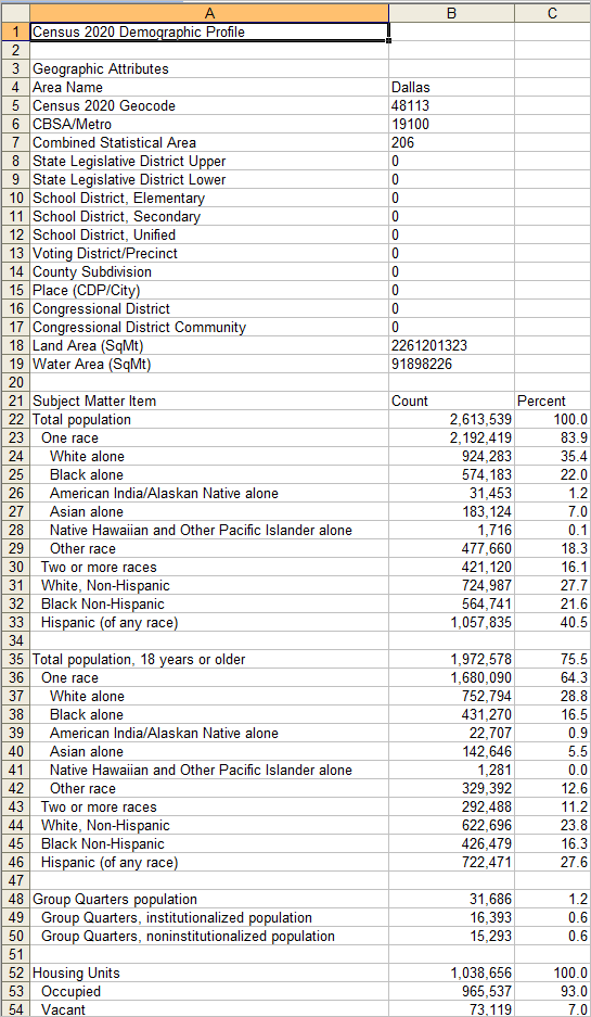
• in the above view that you have created, click on Dallas County in the Map Window.
• the demographic profile for Dallas County appears in the lower left Profile Panel.
• click the copy-to-clipboard button under the Profile Panel.
• open the Census 2020 excel profile template
- in the Excel spreadsheet, Ctrl-V or paste into cell L1.
- the profile should appear as shown below.
The profile shows selected geographic attributes in the upper rows and Census 2020 demographics in the lower section.
To compare one county to another, after proceeding as above:
• in the spreadsheet, copy columns 2 and 3 and paste into D1
• click on another county in the map window, copy to clipboard
• in the spreadsheet, paste into N1
The counties how appear side by side. Continue similarly with more areas.
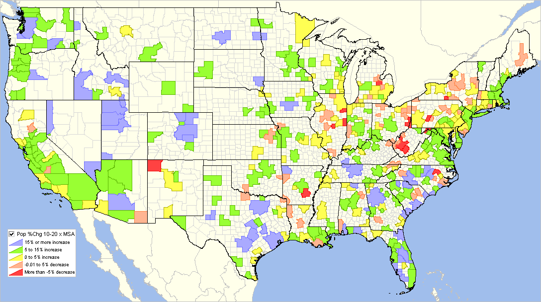
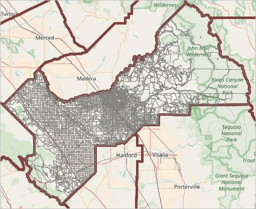
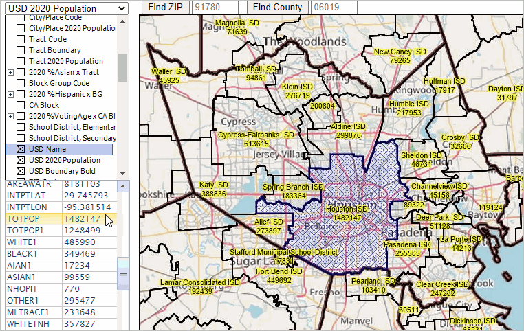
Examining Metro Demographic Change: Census 2010 - Census 2020 .. part of tutorials
Use the "Base" project to view/examine how metropolitan area demographics have changed from Census 2010 to Census 2020.
The following notes show how to do this.
With the Base project open, proceed as follows:
• select the "Metro 2020" layer in the upper left dropdown, making it the Active Layer.
• check the "Pop %Chg 10-20 x MSA" layer on.
• click the expand button to the left of that checkbox.
• uncheck the click the "Pop %Chg 10-20 x County" layer.
• the view shown below now appears.
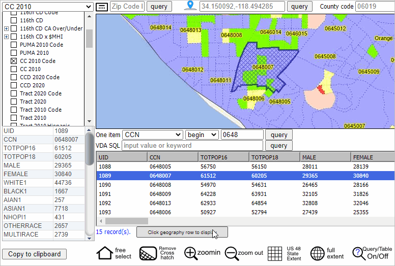
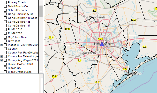
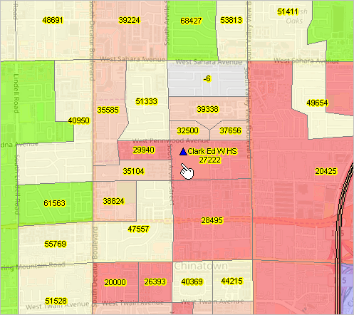
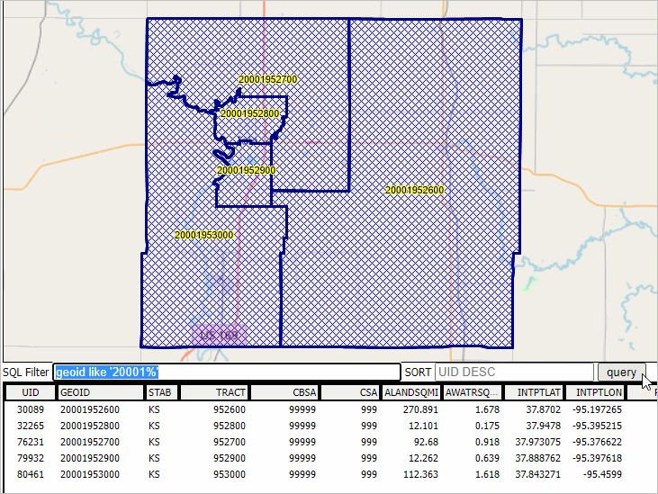
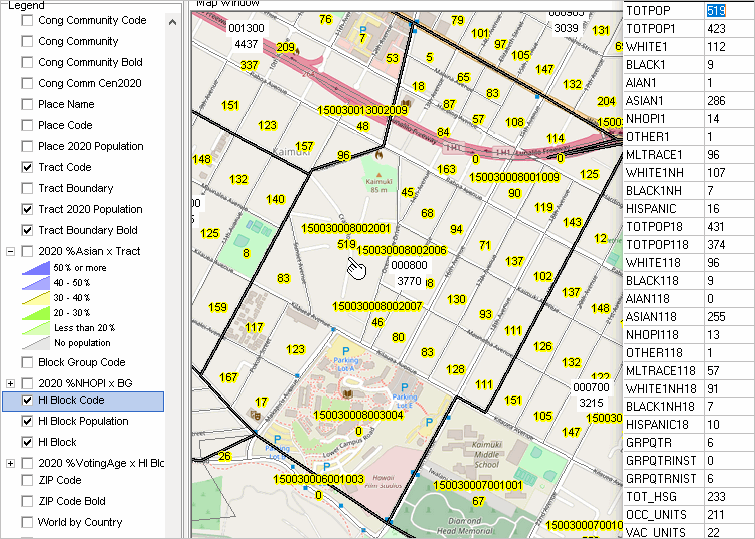
Examining Census Tract Demographic-Economic Characteristics .. part of tutorials .. goto top
Use the "Situation & Outlook" (S&O) project to view/examine census tract demographic-economic characteristics.
See details about the S&O project below.
With the S&O project open, proceed as follows:
Map View and Pattern Analysis
• click/check on the "$MHI x Tract ACS2019" layer in the Legend Panel.
.. the map window refreshes to display patterns of median household income by census tract
• click interval expansion button at left of the "$MHI x Tract ACS2019" layer name in the Legend Panel
.. to view the color/interval settings
.. the view should look similar to the following graphic; click graphic for larger view.
Table View and Analytics
• select the "$MHI x Tract ACS2019" layer in the upper left dropdown, making it the Active Layer.
• click the Query/Table button below Map Window at far right.
.. the screen refreshes with with a split view of Map Window and Table.
.. the table shows a row for each tract.
• join us in a Tuesday or Thursday web session to learn more about using the table and map.
.. end of tutorials section.
VDA GIS Projects .. goto top
A GIS project is a set of "layers" each
associated with a geographic file (an SQLite database in the case of VDA) with an integrated set of subject matter items ("attributes").
With VDA in operation, layers are shown in the legend panel.
A GIS project has initial start-up settings
that are the codifications for visual Map Window rendering like color assignments, attribute to be rendered, etc.
Attributes are fields like geocode, geographic object name, or total population.
VDA has these initial projects available for use. This project list is presented in the Project Manager form presented after login.
The list of available projects ("VDA projects") varies over time with new developments such as data availability.
These are projects developed for general use. Users may add and delete layers from these projects and save them for their own use.
Users may also create their own GIS projects, eith building on the Base project or uploading a GIS project for their own exclusive use.
Level 2 users may modify existing projects, add/delete layers, and save/delete projects.
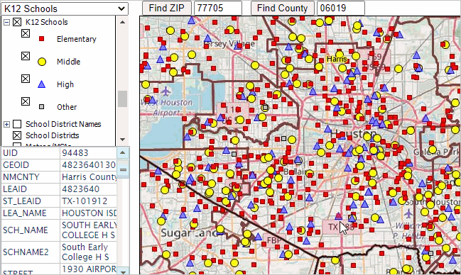
K-12 Schools & School Districts Project
Using this project
.. see this section that shows use of this project
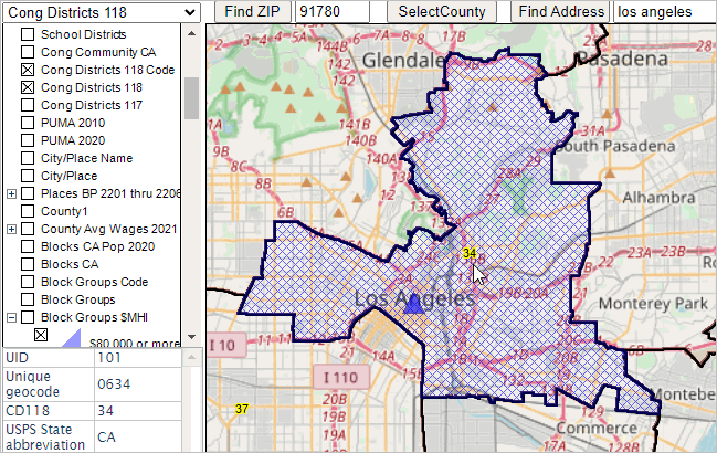
Congressional Communities/Congressional Districts No Login .. goto top
Two variations of the Congressional Communities (CC/CD) GIS projects are supported by VDA.
They have similar layers/shapefiles included but slightly different start-up GIS project files.
Access these projects via the standard login page these CC/CD project appear on the project selection form:
Congressional Districts project
.. start-up view shows the U.S. by 118th Congressional District
.. active layer is 118th Congressional Districts
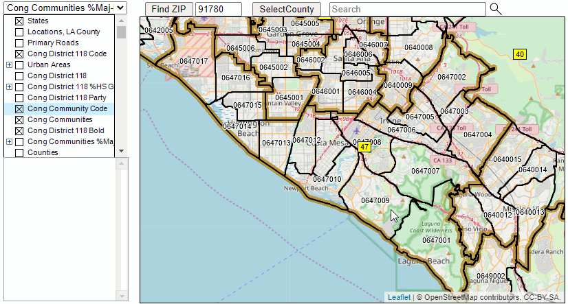
.. optionally start this project with direct access Congressional Districts CA 47 project
.. start-up view shows zoom-to CD 118 CA 47 and related layers (see below)
.. active layer is Congressional Communities
Notes about using the Congressional Districts project
.. find a Congressional District & view characteristics ..
• start project here
.. wait for full map interface display; might take 8-10 seconds.
.. the active layer is Cong Dist 118 (see in upper left dropdown).
.. option 1 .. using mouse, click any congressional district area in map.
- CD crosshatches
- profile appears in lower left panel.
- optionally click HTML button below profile for better view in new table HTML page.
.. the active layer is Cong Dist 118 (see in upper left dropdown).
.. option 2 .. find a district based on an address.
- key in address in search bar above map, then press enter.
- map refreshes with zoom to address location/CD and shows blue marker.
- using mouse, click blue marker; CD then highlights and shows profile as above.
.. find a Congressional Community & view characteristics
.. set the active layer as Cong Communities using upper left dropdown.
.. key in address in search bar above map, then press enter.
.. map refreshes with zoom to address location and shows blue marker.
.. in legend panel at left click checkbox on for Cong Communities (CC) layer.
- CC boundaries display in map windowe,
.. using mouse, click blue marker; CC then highlights and shows profile as above.
.. optionally click HTML button below profile for better view in new table HTML page.
Read on about the Congressional Communities Project or .. goto top
Congressional Communities Project
Congressional Communities project .. VDA project with wide array of production data.
.. Congressional Communities (nesting within 118th Congressional Districts)
This project includes extensive data from multiple sources:
.. 118th Congressional Districts
.. Congressional Communities (nest in 118th CDs; developed from
2020 Censuscensus blocks)
.. Census 2020
.. American Community Survey
.. Model-based estimates
.. other data
Using this project
.. see this section that shows use of this project
Using this project with VDA Desktop GIS
.. get added capabilities and speed using this project VDA Desktop GIS
.. install VDA Desktop GIS (via VDA Web GIS) -- requires Windows
.. start VDA Desktop; use File>Open Server Project (menu bar).. then select Congressional Communities.
.. this user interface is similar to VDA Web GIS but differs some.
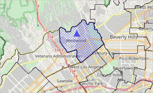
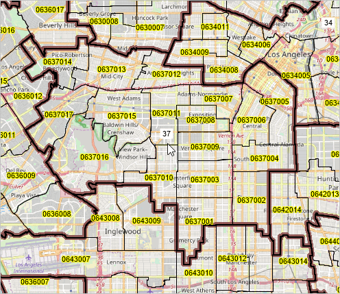
Illustrative start-up view using VDA Web GIS.
Zoom-in view of CA CD 47
The default active layer in this project (upper left dropdown) is Congressional Communities (CC).
- click on a CC in map to show that CC as cross-hatched and show profile in lower left panel.
- then click HTML button to view that profile in a new HTML page.
Optionally use Tools>Profile to view/save a comparative analysis profile.
County/Regional Trends
.. County Trends and metros
This project includes extensive data from multiple sources:
.. Census 2020
.. American Community Survey
.. Model-based estimates
.. other non-Federal statistical data
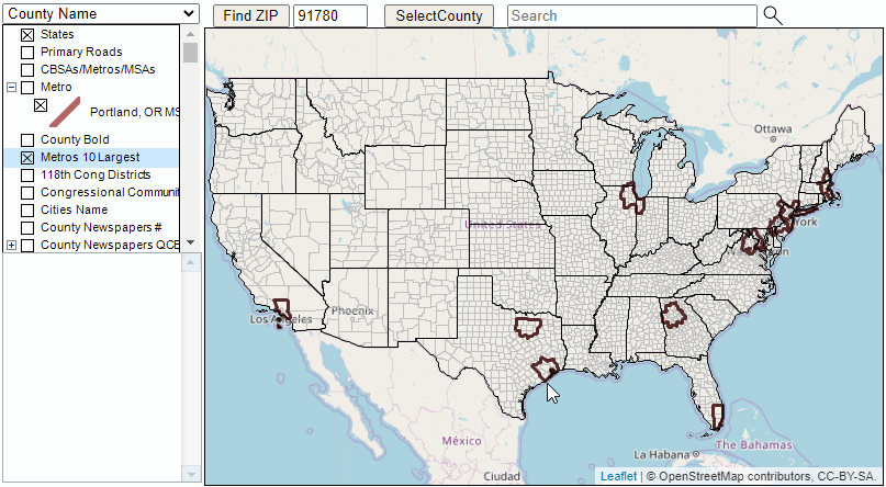
Illustrative start-up view.
U.S. 48 contiguous states showing counties and 10 largest metros
The default active layer in this project (upper left dropdown) is Counties.
- click on a county in map to show that county as cross-hatched and show profile in lower left panel.
- then click HTML button to view that profile in a new HTML page.
Congressional Districts/SLD
.. Congressional Disitricts and state legislative districtss
.. Census 2020
.. American Community Survey
.. Model-based estimates
.. other non-Federal statistical data
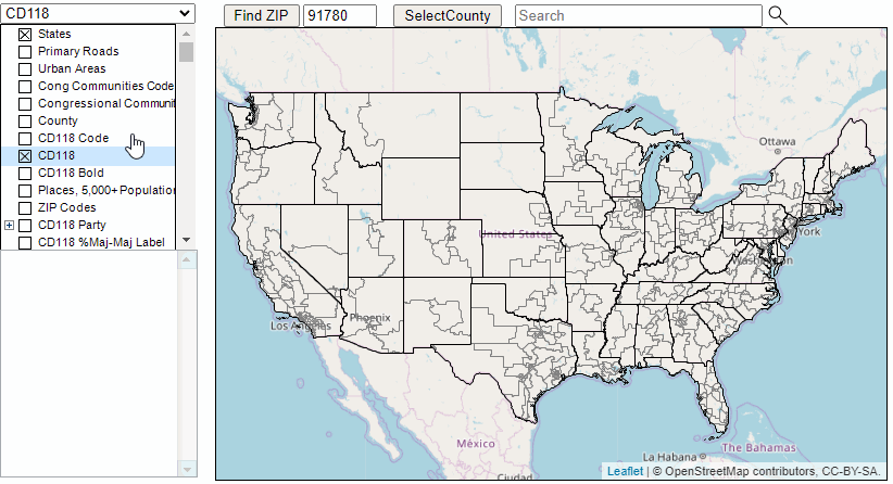
Illustrative start-up view.
U.S. 48 contiguous states showing 118th congressional districts
The default active layer in this project (upper left dropdown) is 118th Congressional Districts (CD).
- click on a CD in map to show that CD as cross-hatched and show profile in lower left panel.
- then click HTML button to view that profile in a new HTML page.
The Situation & Outlook (S&O) project .. main VDA project with wide array of production data.
This project includes extensive data from multiple sources:
.. Census 2010
.. Census 2020
.. American Community Survey
.. Model-based estimates
.. other non-Federal statistical data
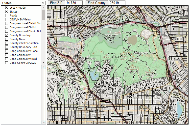
This project includes these layers (scroll section):
.. the S&O project includes these layers (U.S. national scope unless otherwise noted):
States
State Label
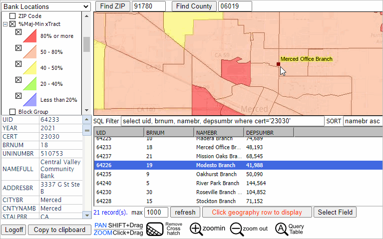
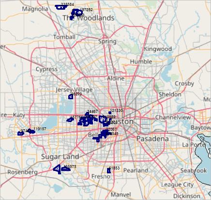
Banks - FDIC Insured Bank Locations
Banks 01331 23030 24734 - selected illustrative FDIC Insured Bank Locations
Primary Roads - primarily interstate roads
CA PriSec Roads - California primary-secondary roads
Los Angeles Cty Roads - Los Angeles County, CA intersection-to-intersection streets/roads
CSA 2020 - national scope Combined Statistical Areas
CBSA/MSA 2020 - Core-Based Statistical Areas (MSAs & MISAs); Census 2020
County Label - County boundaries 2020
County %PopChg 10-20 - County boundaries; thematic pattern; percent change in population, 2010-2020
Places ACS2019 - Census 2010 place boundaries with integrated ACS2019 demographic-economic data
Places 2020 - Census 2020 city/place boundaries
Cong Dist Code - 116th congressional districts code
Cong Dist - 116th congressional districts boundary
Cong Dist Bold - 116th congressional districts boundary (bold)
$MHI x Cong Dist - 116th CD boundaries; thematic pattern; median household income, ACS2019 1 year
PUMA 2010 Code - Census 2010 Public Use Microdata Area (PUMA) boundaries - code
PUMA 2010 - Census 2010 PUMA boundaries
$MHI x PUMA ACS2019 - Census 2010 PUMA boundaries; thematic pattern; median household income, ACS2019 1 year
Congressional Community Code
Cong Community - Congressional Communities boundaries
Cong Community Bold Congressional Communities bold boundaries
Cty SubDiv 2020 - Census County Division boundarie
Tract 2020 Code - Census Tract 2020 Code
%Maj-Min x Tract 2020 - Census Tract 2020 boundary; thematic pattern: Census 2020 %majority-minority population
Tract 2010 Code - Census Tract 2010 code
Tract 2010 - Census Tract 2010 boundary
Tract 2010 LMI 2021 - Census Tract 2010 LMI classification label; Low & Moderate Income
$MHI x Tract ACS2019 - Census Tract 2010 boundary; thematic pattern: median household income
BG 2020 Code - Block Group Census 2020 code as label
BG 2020 - Block Group Census 2020 boundaries
BG 2010 Code - Block Group Census 2010 code as label
BG 2010 ACS2019 - Block Group Census 2010 boundaries
LA Neighborhoods - Los Angeles City neighborboods (L.A. Times)
CA Block 2020 Code - California Census Block 2020 code as label
CA Block 2020 - California Census Block 2020 boundaries
K12 School Name - K-12 public schools; name as label
K12 Schools = K-12 public schools as markers (by school level)
School District Names -
School Districts 2020
School Districts
ZIP Code
ZIP Code Bold
$MHI x ZIP Code
$MHV x ZIP Code
Establishments x ZIP
Country Projections 2050
World by Country
OpenStreetMaps Tiles
States1
The MetroDynamics project .. main VDA project with wide array of production data. see more
The TIGER project .. VDA project with wide array of production data.
This project includes extensive data from multiple sources:
.. Census 2010
.. Census 2020
.. American Community Survey
.. Model-based estimates
.. other non-Federal statistical data
The Arizona SRDMI project .. VDA project with wide array of production data. see more
The Nevada SRDMI project .. VDA project with wide array of production data. see more
The SBISD project .. VDA project with wide array of production data.
The Base project is comprised of basic layers intended for use by users to augment into their own projects.
.. all Census 2020 geography except ZIP code layer (includes latest ACS data).
.. opening view: thematic pattern view shows U.S. by county population percent change, 2010-2020.
- subject matter available for that county layer is shown in this interactive table
.. the Base project is also used as a "base" for developing several other projects.
.. the Base project includes these layers:
States - U.S. by State
Roads - U.S. Primary Roads
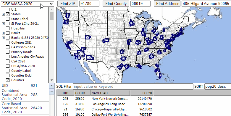
CBSA/MSA/Metro - U.S. Core Based Statistical Areas
MSA Name - Metropolitan Statistical Areas
MSA Pop 2020 - MSA Census 2020 population label
Pop %Chg 10-20 x MSA - thematic pattern layer: population Census 2010-2020 % change by MSA
Congressional District - U.S. by congressional district
Congressional Community - U.S. by congressional community
City/Place - U.S. cities/places
County Name - U.S. county name as label
County - U.S. by county boundary
Pop %Chg 10-20 x County - thematic pattern layer: population Census 2010-2020 % change by county
Tract - U.S. census tracts=
Block Group - U.S. block group
School District, Elementary - U.S. elementary school districts
School District, Secondary - U.S. secondary school districts
School District, Unified - U.S. unified school districts
ZIP Code - ACS 2019 U.S. ZIP Code areas with ACS 2019 demographics
Urban Areas - ACS 2019 Urban Areas
World by Country
BaseLayer - OSM Tiling topology
States1 - U.S. lower 48 states
Census 2020 .. VDA project with wide array of production data.
This project includes extensive data from multiple sources:
.. Census 2010
.. Census 2020
.. American Community Survey
.. Model-based estimates
.. other non-Federal statistical data
The Census2020 project includes these layers (scroll section):
States
State Label
CSA 2020 - national scope Combined Statistical Areas
CBSAs 2020 - national scope Core-Based Statistical Areas (MSAs & MISAs); Census 2020
County Outline -- national scope U.S. layer useful as "top layer" for many views
.. a set of national scope city/place layers
Cities Name - Census 2010 with integrated demographics
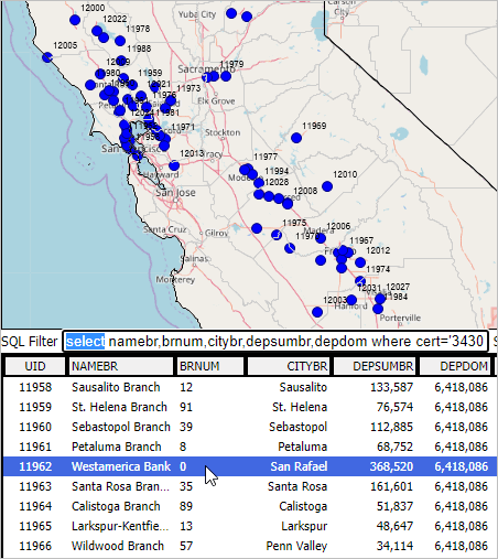
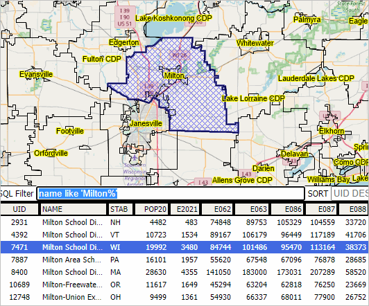
Table query example: select uid, name, stab where name like 'Santa Clarita%'
Places 2020
Cities Population
Cities
.. a set of California roads/streets layers; add your own using the upload layers feature
CA Roads Name - primary roads name
CA Roads1 - primary roads light
CA Roads2 - primary roads bold
Orange Cty Roads - Orange County intersection-to-intersection detailed roads/streets
Los Angeles Cty Roads - LA County intersection-to-intersection detailed roads/streets
.. "location" layers illustrate how you can add and use point/location data
Locations 06037
Locations 06059
.. national scope congressional district layers
Cong Dist Code
Cong Dist
Cong Dist Bold
$MHI x Cong Dist
Cty SubDiv 2020 -- census county divisions; administrative subdivisions of counties (towns in New England)
.. these tract layers enable you to compare how census tract boundaries changed from 2010 to 2020.
Tract 2020 Code
Tract 2020
Tract 2010 Code
Tract 2010
Tract 2010 Hispanic
$MHI x Tract ACS2019 -- the most recent "richer demographics"
.. these block group enable you to compare how block group boundaries changed from 2010 to 2020.
BG 2020 Code
BG 2020
BG 2010 Code
BG 2010
.. integrate non-statistical data
LA Neighborhoods -- Los Angeles neighborhoods developed by the Los Angeles Times
.. examine Census 2020 census block data for California (add others using the Upload Layers feature
CA Block 2020 Code
CA Block 2020
.. examine national scope K-12 schools and school districts
K12 School Name
K12 Schools
School District Names
School Districts 2020
School Districts
.. national scope metropolitan statistical areas .. see more about CBSAs - the CBSA layer at top of list
Metros/MSAs
Metros/MSA Name
Metros/MSA Population
.. national scope counties
Counties Name
Counties Population
Cty Pop Gain 2010-19
Cty Pop Loss 2010-19
County PCPI
County PCPI
.. national scope ZIP code layers
ZIP Code - ZIP code as a label
ZIP Code Bold - bold boundary useful to highlight ZIP areas when using multiple geographic levels
$MHI x ZIP Code - median household income thematic pattern
$MHV x ZIP Code - median housing value thematic pattern
Establishments x ZIP -- business establishments by ZIP code
.. examine the global situation
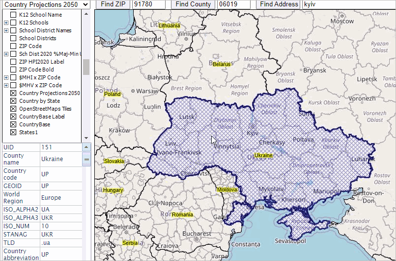
Country Projections 2050
World by Country
.. global tiling layer providing views of underlying topology
OpenStreetMaps Tiles
.. this national scope "base layer" serves just that purpose
States1
Tract S&O Layer: Subject Matter Items & Use .. goto top
The Tract S&O Layer is a U.S. national scope Census 2010 census tracts layer with approximatey 235 subject matter items
selected from the 2019 ACS statistical program.
This layer is available in the S&O project (named $MHI x Tract S&O in the VDA legend).
Subject matter items included in this layer are listed below.
This section is focused on using this layer with the VDA Query/Table operations.
Access this section (being presently viewed) via this link: http://proximityone.com/vda.htm#tracts_sao
These data are a part of the census tract demographic estimates and projections to 2026.
Learn more about how neighborhood level demographic-economic conditions might change.
See tract estimates and projections for details.
Create your own VDA interactive table using this layer
Using the S&O project ...
1. Select the "$MHI x Tract S&O" (top left dropdown) making it the active layer.
2. Click the "Query/Table" button at right below map window. Table then displays below window.
3. Enter the value 100000 in the "max" edit box below grid.
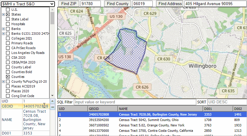
After step 2, the view appears as shown below; here are a few orienteering notes:
.. the selected/active layer is shown in the upper left edit box.
.. the attributes of this layer are shown in the table/grid below the map window.
.. there is a row for each tract in the U.S.
.. the name field has been expanded (drag field name separator) in table header.
.. the first row in the table has been clicked, making it the selected tract, coloring it blue.
.. the button "click geography in row to display" is clicked, resulting in:
- the profile panel (lower left) shows attributes of this tract.
- the map window refreshes with a zoom to this tract.
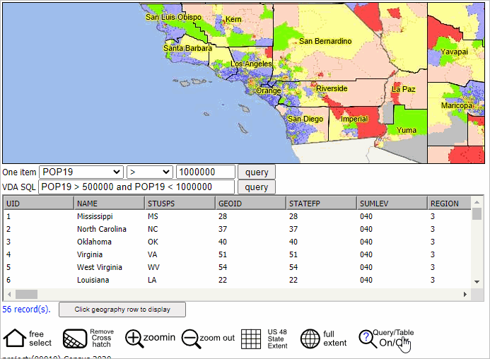
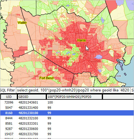
Application examples featuring E062 - median household income
The item "E062" is median household income (see in table below). Use any combination of items,
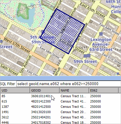
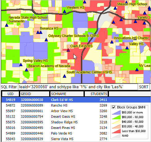
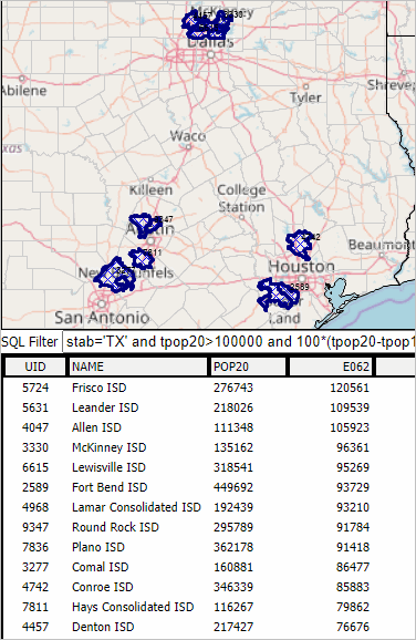
App 1. E062 is "top-coded" with the value $250,000. How many tracts are top-coded? What/where are the tracts?
Enter the following text in the SQL Filter edit box then click the query button:
select geoid,name,e062 where e062>=250000
The grid refreshes showing the tracts that meet the query criteria (e062>=250000) :
There are 114 tracts that meet this query; see in edit box below table.
Continuing with App 1, click "Highlight all that meet query" button below table.
The following view appears where the map is refreshed with zoom to to first tract in table
Optionally click zoom-out button 2-3 times to see that all tracts in the table are mapped/highlighted.
.. caution clicking on the map to avoid an unwanted highlighting of that tract.
App 2. Show a list of tracts that have $MHI (E062) between $248,000 and $250,000 in California
This query shows how to narrow a search based on more "where" criteria.
Enter the following text in the SQL Filter edit box then click the query button:
select geoid,name,e062 where e062>248000 and e062<250000 and geoid like '06%'
The grid refreshes with a view of 4 tracts.
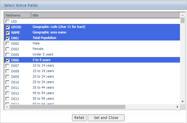
App 3. Using "Select Field" feature to Select Items for Grid Display
This layer has more than 235 items. Select items to be displayed in the gridi
Click the Select Field button below the Table/Grid.
.. the Select Field form appears .. click checkbox on a few items and click "Set and Close" button.
The grid display refreshes showing the selected items.
Use the "Select Field" to view the metadata - descriptions for each attribute.
.. not fully populated with description column in all layers.
Tract S&O Layer Subject Matter Items (scroll section)
Use the ItemName in VDA applications.
ItemName Description
GEOID
Tract Geographic Code (Char 11 -- SSCCCTTTTTT)
NAME
Tract Name (includes county name and state USPS abbreviation)
D001
Total Population
D002
Male
D003
Female
D005
Under 5 years
D006
5 to 9 years
D007
10 to 14 years
D008
15 to 19 years
D009
20 to 24 years
D010
25 to 34 years
D011
35 to 44 years
D012
45 to 54 years
D013
55 to 59 years
D014
60 to 64 years
D015
65 to 74 years
D016
75 to 84 years
D017
85 years and over
D018
Median age (years)
D019
Under 18 years
D021
18 years and over
D022
21 years and over
D023
62 years and over
D024
65 years and over
Race/Origin
D036
One Race
D037
One Race -- White
D038
One Race -- Black or African American
D039
One Race -- American Indian and Alaska Native
D044
One Race -- Asian
D052
One Race -- Native Hawaiian and Other Pacific Islander
D057
One Race -- Some other race
D058
Two or more races
D071
Hispanic or Latino (of any race)
D072
Hispanic or Latino (of any race) -- Mexican
D077
Not Hispanic or Latino -- White Alone
D078
Not Hispanic or Latino -- Black or African American Alone
D087
Citizen, 18 and over
Housshold characteristics
S001
Total Households
S002
Total Households -- Family Households (Married-couple family)
S016
Average household size
S017
Average family size
S018
Population in households
School Enrollment
S053
School Enrollment -- Population 3 Years and Over Enrolled in School
S054
School Enrollment -- Population 3 Years and Over Enrolled in School -- Nursery school, preschool
S055
School Enrollment -- Population 3 Years and Over Enrolled in School -- Kindergarten
S056
School Enrollment -- Population 3 Years and Over Enrolled in School -- Elementary school (grades 1-8)
S057
School Enrollment -- Population 3 Years and Over Enrolled in School -- High school (grades 9-12)
S058
School Enrollment -- Population 3 Years and Over Enrolled in School -- College or graduate school
Educational attainment
S059
Educational Attainment -- population 25 years and over
S060
Educational Attainment -- population 25 years and over -- Less than 9th trade
S061
Educational Attainment -- population 25 years and over -- 9th to 12th grade, no diploma
S062
Educational Attainment -- population 25 years and over -- High school graduate (includes equivalency)
S063
Educational Attainment -- population 25 years and over -- Some College, No Degree
S064
Educational Attainment -- population 25 years and over -- Associate's Degree
S065
Educational Attainment -- population 25 years and over -- Bachelor's Degree
S066
Educational Attainment -- population 25 years and over -- Graduate or Professional
S067
Educational Attainment -- population 25 years and over -- High school graduate or higher
S068
Educational Attainment -- population 25 years and over -- Bachelor's degree or higher
Mobility/Migration
S079
Residence 1 Year Ago -- Population 1 year and over
S080
Residence 1 Year Ago -- Same House
S081
Residence 1 Year Ago -- Different House in the U.S.
S082
Residence 1 Year Ago -- Different House in the U.S. -- Same County
S083
Residence 1 Year Ago -- Different House in the U.S. -- Different County
S084
Residence 1 Year Ago -- Different House in the U.S. -- Different County -- Same State
S085
Residence 1 Year Ago -- Different House in the U.S. -- Different County -- Different state
S086
Residence 1 Year Ago -- Abroad
S088
Place of Birth -- Native
S089
Place of Birth -- Native -- Born in U.S.
S090
Place of Birth -- Native -- Born in U.S. -- State of Residence
S091
Place of Birth -- Native -- Born in U.S. -- Different State
S092
Place of Birth -- Native -- Born in Puerto Rico, U.S. Island Areas, or Born Abroad
S093
Place of Birth -- Foreign Born
S094
U.S. Citizenship Status -- Foreign-Born Population
S095
U.S. Citizenship Status -- Foreign-Born Population -- Naturalized U.S. Citizen
S096
U.S. Citizenship Status -- Foreign-Born Population -- Not a U.S. Citizen
Language spoken at home
S111
Language Spoken at Home -- Population 5 Years and Over
S112
Language Spoken at Home -- Population 5 Years and Over -- English Only
S113
Language Spoken at Home -- Population 5 Years and Over -- Language Other Than English
S114
Language Spoken at Home -- Population 5 Years and Over -- Language Other Than English - less than very well
S115
Language Spoken at Home -- Population 5 Years and Over -- Language Other Than English - Spanish
S116
Language Spoken at Home -- Population 5 Years and Over -- Language Other Than English - Spanish, less than very well
S151
Computers and Internet Use -- Total Households
S152
Computers and Internet Use -- Households with a Computer
S153
Computers and Internet Use -- Households with a broadband Internet subscription
Employment status
E001
Employment Status -- Population 16 years & over
E002
Employment Status -- Population 16 years & over -- in Labor Force
E003
Employment Status -- Population 16 years & over -- Civilian Labor Force
E004
Employment Status -- Population 16 years & over -- Employed
E005
Employment Status -- Population 16 years & over -- Unemployed
E006
Employment Status -- Population 16 years & over -- Armed Forces
E007
Employment Status -- Population 16 years & over -- Not in Labor Force
E009
Employment Status -- Population 16 years & over -- Percent Unemployed
Employment by industry
E032
Industry -- Civilian Employed Population 16 years & over
E033
Industry -- Civilian Employed Population 16 years & over -- Agriculture, Forestr
E034
Industry -- Civilian Employed Population 16 years & over -- Construction
E035
Industry -- Civilian Employed Population 16 years & over -- Manufacturing
E036
Industry -- Civilian Employed Population 16 years & over -- Wholesale Trade
E037
Industry -- Civilian Employed Population 16 years & over -- Retail Trade
E038
Industry -- Civilian Employed Population 16 years & over -- Transportation and warehousing, and utilities
E039
Industry -- Civilian Employed Population 16 years & over -- Information
E040
Industry -- Civilian Employed Population 16 years & over -- Finance & insurance, & real estate & rental & leasing
E041
Industry -- Civilian Employed Population 16 years & over -- Professional, scientific & mgmt, & admin & waste mgmt svc
E042
Industry -- Civilian Employed Population 16 years & over -- Educational Services
E043
Industry -- Civilian Employed Population 16 years & over -- Arts, Entertainment
E044
Industry -- Civilian Employed Population 16 years & over -- Other Services
E045
Industry -- Civilian Employed Population 16 years & over -- Public Administration
E046
Class of Worker -- Civilian Employed Population 16 years & over
E047
Class of Worker -- Civilian Employed Population 16 years & over -- Private Wage & Salary
E048
Class of Worker -- Civilian Employed Population 16 years & over -- Government Workers
E049
Class of Worker -- Civilian Employed Population 16 years & over -- Self-Employed
E050
Class of Worker -- Civilian Employed Population 16 years & over -- Unpaid Family
Income & Benefits
E051
Income and Benefits -- Total Households
E052
Income and Benefits -- Households -- Less Than $10,000
E053
Income and Benefits -- Households -- $10,000 to $14,999
E054
Income and Benefits -- Households -- $15,000 to $24,999
E055
Income and Benefits -- Households -- $25,000 to $34,999
E056
Income and Benefits -- Households -- $35,000 to $49,999
E057
Income and Benefits -- Households -- $50,000 to $74,999
E058
Income and Benefits -- Households -- $75,000 to $99,999
E059
Income and Benefits -- Households -- $100,000 to $149,999
E060
Income and Benefits -- Households -- $150,000 to $199,999
E061
Income and Benefits -- Households -- $200,000 or More
E062
Income and Benefits -- Households -- Median Household Income (Dollars)
E063
Income and Benefits -- Households -- Mean Household Income (Dollars)
E064
Income and Benefits -- Households -- with Earnings
E065
Income and Benefits -- Households -- with Earnings -- Mean Earnings (Dollars)
E066
Income and Benefits -- Households -- with Social Security
E067
Income and Benefits -- Households -- with Social Security -- Mean Social Security Income ($)
E068
Income and Benefits -- Households -- with Retirement Income
E069
Income and Benefits -- Households -- with Retirement Income -- Mean Retirement Income ($)
E070
Income and Benefits -- Households -- with Supplemental Security Income
E071
Income and Benefits -- Households -- with Supplemental Security Income -- Mean Supplemental Security Income ($)
E072
Income and Benefits -- Households -- with Cash Public Assistance Income
E073
Income and Benefits -- Households -- with Cash Public Assistance Income -- Mean cash public assistance income ($)
E074
Income and Benefits -- Households -- with Food Stamp/Snap Benefits in the Past 12 months
E075
Income and Benefits -- Families
E076
Income and Benefits -- Families -- Less Than $10,000
E077
Income and Benefits -- Families -- $10,000 to $14,999
E078
Income and Benefits -- Families -- $15,000 to $24,999
E079
Income and Benefits -- Families -- $25,000 to $34,999
E080
Income and Benefits -- Families -- $35,000 to $49,999
E081
Income and Benefits -- Families -- $50,000 to $74,999
E082
Income and Benefits -- Families -- $75,000 to $99,999
E083
Income and Benefits -- Families -- $100,000 to $149,999
E084
Income and Benefits -- Families -- $150,000 to $199,999
E085
Income and Benefits -- Families -- $200,000 or More
E086
Income and Benefits -- Families -- Median Family Income (Dollars)
E087
Income and Benefits -- Families -- Mean Family Income (Dollars)
E088
Income and Benefits -- per Capita Income (Dollars)
E089
Nonfamily households
E090
Income and Benefits -- Median Nonfamily Income (Dollars)
E091
Income and Benefits -- Mean Nonfamily Income (Dollars)
E092
Income and Benefits -- Median Earnings for Workers (Dollars)
E093
Income and Benefits -- Median Earnings for Male Full-Time, Year-Round Workers ($)
E094
Income and Benefits -- Median Earnings for Female Full-Time, Year-Round Workers ($)
Health insurance
E095
Health Insurance Coverage -- .. Civilian Noninstitutionalized Population
E096
Health Insurance Coverage -- .... with Health Insurance Coverage
E097
Health Insurance Coverage -- ...... with Private Health Insurance Coverage
E098
Health Insurance Coverage -- ...... with Public Health Coverage
E099
Health Insurance Coverage -- .... No Health Insurance Coverage
Housing characteristics
H001
Total Housing Units
H002
Occupied Housing Units
H003
Vacant Housing Units
H004
Homeowner Vacancy Rate
H005
Rental Vacancy Rate
H007
Units in Structure -- 1-Unit, Detached
H008
Units in Structure -- 1-Unit, Attached
H009
Units in Structure -- 2 Units
H010
Units in Structure -- 3 or4 Units
H011
Units in Structure -- 5 to 9 Units
H012
Units in Structure -- 10 to 19 Units
H013
Units in Structure -- 20 or More Units
H014
Units in Structure -- Mobile Home
H015
Units in Structure -- Boat, Rv, Van, Etc.
H017
Year Built -- 2014 or later
H018
Year Built -- 2010 to 2013
H019
Year Built -- 2000 to 2009
H020
Year Built -- 1990 to 1999
H021
Year Built -- 1980 to 1989
H022
Year Built -- 1970 to 1979
H023
Year Built -- 1960 to 1969
H024
Year Built -- 1950 to 1959
H025
Year Built -- 1940 to 1949
H026
Year Built -- 1939 orEarlier
H037
Rooms -- Median Rooms
H046
Tenure -- Owner-Occupied
H047
Tenure -- Renter-Occupied
H048
Average Household Size of Owner-Occupied Unit
H049
Average Household Size of Renter-Occupied Unit
H051
Year Householder Moved into Unit -- 2017 or later
H052
Year Householder Moved into Unit -- 2015 to 2016
H053
Year Householder Moved into Unit -- 2010 to 2014
H054
Year Householder Moved into Unit -- 2000 to 2009
H055
Year Householder Moved into Unit -- 1990 to 1999
H056
Year Householder Moved into Unit -- 1989 or earlier
H058
Vehicles Available -- No Vehicles Available
H059
Vehicles Available -- 1 Vehicle Available
H060
Vehicles Available -- 2 Vehicles Available
H061
Vehicles Available -- 3 or More Vehicles Available
H063
House Heating Fuel -- Utility Gas
H064
House Heating Fuel -- Bottled, Tank, or LP Gas
H065
House Heating Fuel -- Electricity
H066
House Heating Fuel -- Fuel Oil, Kerosene, Etc.
H067
House Heating Fuel -- Coal orCoke
H068
House Heating Fuel -- Wood
H069
House Heating Fuel -- Solar Energy
H077
Occupants per Room -- 1.00 or Less
H078
Occupants per Room -- 1.01 to 1.50
H079
Occupants per Room -- 1.51 or More
Housing value
H081
Value -- Less than $50,000
H082
Value -- $50,000 to $99,999
H083
Value -- $100,000 to $149,999
H084
Value -- $150,000 to $199,999
H085
Value -- $200,000 to $299,999
H086
Value -- $300,000 to $499,999
H087
Value -- $500,000 to $999,999
H088
Value -- $1,000,000 or More
H089
Value -- Median (Dollars)
H090
Owner-Occupied Units
H091
Mortgage Status -- Housing Units with a Mortgage
H092
Mortgage Status -- Housing Units Without a Mortgage
H126
Occupied Units Paying Rent
H127
Gross Rent -- Less than $500
H128
Gross Rent -- $500 to $999
H129
Gross Rent -- $1,000 to $1,499
H130
Gross Rent -- $1,500 to $1,999
H131
Gross Rent -- $2,000 to $2,499
H132
Gross Rent -- $2,500 to $2,999
H133
Gross Rent -- $3,000 or More
H134
Gross Rent -- Median ($)
H135
Gross Rent -- No Rent Paid
H136
Occupied units paying rent (excluding units where GRAPI cannot be computed)
H137
Gross Rent as a Percentage of Household Income (GRAPI) -- Less Than 15.0 Percent
H138
Gross Rent as a Percentage of Household Income (GRAPI) -- 15.0 to 19.9 Percent
H139
Gross Rent as a Percentage of Household Income (GRAPI) -- 20.0 to 24.9 Percent
H140
Gross Rent as a Percentage of Household Income (GRAPI) -- 25.0 to 29.9 Percent
H141
Gross Rent as a Percentage of Household Income (GRAPI) -- 30.0 to 34.9 Percent
H142
Gross Rent as a Percentage of Household Income (GRAPI) -- 35.0 Percent or More
Subscription & Levels .. goto top
There are three levels VDA operation.
.. Level 2 single user monthly subscription -- $395 -- $290 setup fee; $95 monthly
.. Level 2 single user annual subscription -- $995 -- setup fee included; includes VDA Desktop (Windows)
• Level 3 -- features of Level 2 augmented
.. availablility of selected features not available to Level 1 or 2.
- Project Editor
.. this is a Census 2020 and ACS delivery platform, integrating with other data.
.. ability to create, modify and upload GIS projects (add to your "available projects" list)
.. one hour connect time per month per user (5 cumulative hours).
.. access to the continuously (weekly) updated augmented "Census 2020" project.
- includes access to most Census 2020 and ACS 2020 data, updated on an as released basis.
- this project, project suite, includes multi-sourced data, not only Census sourced data.
- quarterly updates on BLS QCEW data, other BLS data, BEA REIS local area data, other BEA data, yet other.
.. VDA Desktop single user license
.. DEDE single user license
.. optional availability of other proprietary data.
.. availability of selected features like Project Editor
.. ability to selectively download data
.. support: e-mail & telephone plus Web documentation (this page) & weekly user Web sessions.
• Level 3 for Universities -- use the special licensing terms for departments, campuses or university-wide settings.
.. similar to standard Level 3 features except the number of seats and connect time are increased.
.. College/university students, faculty/staff can use VDA at no cost to you as an individual
when your university has a University license.
• Credits & How They Work
.. One credit is one hour of connect time.
.. Minutes toward a credit are accumulated from log on until log off.
.. Monthly Level 2 subscribers receive 1 credit/usage hour per month
.. Annual Level 2 subscribers receive 2 credit/usage hours per month
.. Allocation of credits expires at end of month without carry over
.. Level 3 subscribers receive 2 credits per user per month for each of up to 5 users
- up to 10 hours total, not sharable between users
- allocation of credits expires at end of month without carry over
.. Level 2 subscribers may purchase credits in 5 credit blocks
- the fee for one 5 credit block is $195
- purchased credit blocks expire at the end of monthly or annual term
.. Level 3 subscribers may purchase credits in 5 credit blocks per user
- the fee for one 5 credit block for each of up to 5 users is $495 (total)
- 25 hours total, 5 hour block not sharable between users
- purchased credit blocks expire at the end of annual term
Using this Document .. goto top
This web section is designed for device independent usage with the same content for any device.
Use the menu to navigate this document. For desktops, the menu appears in the left panel.
For phone and tablet devices, the menu is shown by the "hamburger" icon in the upper left of the window.
Landscape viewing is recommended for smaller display devices.
VDA will operate with most browsers and there is nothing to install.
For the best experience, it is recommended that VDA be used with a larger display device and Windows-based desktop computer.
Terms of Use .. goto top
There is no warranty of any type regarding any aspect of VDA Web GIS.
The user is solely responsible for any aspect of using VDA Web GIS.
Content developed using VDA Web GIS should reference the source as "VDA Web GIS https://vdagis.com".
This document is intended for the sole use by VDA users and prospective users.
User Interface .. goto top
Overall VDA Window
Components of the overall VDA window are described below.
The overall window can be viewed as full screen or resized (drag corner) to meet special needs.
User Interface - Map Window .. goto top
The Map Window occupies most of the User Interface.
As the User Interface is dragged, enlarged, the Map Window expands accordingly.
Operations
• Create a zoom-in or zoom-out view by mouse down, drag, release.
.. lower right to upper left to zoom out.
.. upper left to lower right to zoom in.
• Pan/Drag map view: Shift key+mouse down and drag then release.
• Click on a geographic object in the Map Window to display attributes for that item.
.. the geographic object is determined by the Active Layer (set using Select Layer) at top left of UI.
.. the selected geographic object appears cross-hatched.
.. a profile is displayed in the Profile Panel (see below).
User Interface - Main Menu Bar .. goto top
The Main Menu Bar is located at the top of the User Interface (UI).
The File option enables the user to select a different project or save the current rendering of the Active Project.
The Help open provides access to a wide range of related information.
User Interface - Find Geography Bar .. goto top
The Find Geography toolbar is located above the Map Window.
• Find ZIP Code
.. enter a ZIP code; e.g.; 91780, click query button and the Map Window refreshes.
.. the Map Window refreshes with a zoom to 91780 ZIP polygon and shows ZIP code area with hatch pattern.
• Find County
.. enter a 5-character state-County FIPS code; e.g.; 06019, click query button.
.. the Map Window refreshes with a zoom to Fresno County, CA and shows county area with hatch pattern.
.. find State-County FIPS code using this list.
User Interface - Select Active Layer .. goto top
Select the Active Layer by using the top-left drop-down box.
The default layer is top-most layer shown in the legend panel.
1) The Active Layer is the layer selected for use in clicking on an object in the Map Window.
.. when an object is clicked in the Map Window, the attributes of that object are displayed in the Profile Panel
2) The Active layer is the layer selected for use in the Table/Query operations.
User Interface - Legend Panel .. goto top
The Legend Panel is shown to the left of the Map Window.
The Legend Panel provides a list of all layers in the Active GIS Project.
To make a layer visible in the Map Window, click the checkbox on.
To make a layer invisible in the Map Window, click the checkbox off.
To show intervals/sections that are defined as visible for a layer, check the leftmost toggle for the layer.
To hide/collapse intervals/sections that are defined as visible for a layer, uncheck the leftmost toggle for the layer.
User Interface - Profile Panel .. goto top
The Profile Panel is shown below the Legend Panel.
It shows attributes/fields and their values for items in the Active Layer for an object clicked in the Map Window.
Contents of the Profile Panel may be copied to clipboard by clicking the Copy to Clipboard button below the Panel.
Once in clipboard, it may be pasted (Ctrl-V) to an external application such as a spreadsheet program or text editor.
User Interface - Button Operations .. goto top
Button Operations are shown below the Map Window
• Free Select -- frees elected objects
• Remove Crosshatch -- removes cross-hatch
• Zoom-in -- click to incrementally zoom in
• Zoom-out -- click to incrementally zoom out
• Query/Table On/Off -- toggles Map Window view with Table/Grid view
GeoSelect is used to visually, geospatially select and group geographic objects of the active layer and aggregate their demographic-economic attributes.
For example, GeoSelect can be used to select a set of counties or tracts (examples)
and automatically aggregate summary items for those areas (or lines/points) and display the data in the Profile Panel.
GeoSelect operates on the Active Layer of a project.
The first step is to use a project having a layer that you want to use.
Select the Active Layer using the dropdown at top left.
Next, position the view in the Map Window in the area for analysis.
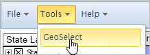
GeoSelect is then started by clicking the Tools>GeoSelect from the Main Menu bar.
GeoSelect Form
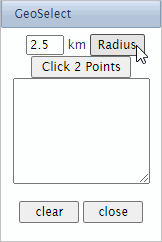
When GeoSelect is started, the GeoSelect form appears:
GeoSelect Operation Options
There are two types of GeoSelect operations described below. The methods should not be mixed.
Click the clear button to change the type of operation.
Radius Button Method
.. click the Radius button then click an Active-Layer-object in the Map Window.
.. Active layer object(s) are selected that intersect within a 2.5 km radius from the point clicked.
.. manually change the radius setting to increase/decrease the radius.
.. as successive shapes/objects are selected they show as crosshatched and become part of the Site Area.
.. using this method it is easy to select and add one polygon the Site Area.
.. as shapes/objects are added to the Site Area, the Profile Panel (lower left) is updated
and displays summary data for the Site Area.
.. optionally use the copy-to-clipboard button below the Profile Panel
to copy and paste the summary data to a speadsheet, text editor, etc.
.. click the Clear button to start over.
Click 2 Points Button Method
.. with the click 2 points method, the radius is set by clicking two points on the Map Window.
- clicking the first time sets the center position for a circle.
a plus marker is shown in the Map Window
- clicking the second time sets the radius for the circle.
a second plus marker is shown in the Map Window
- the circle is shown in the Map Window.
.. as successive shapes/objects are selected they show as crosshatched and become part of the Site Area.
.. using this method it is easy to select and add one polygon the Site Area.
.. as shapes/objects are added to the Site Area, the Profile Panel (lower left) is updated
and displays summary data for the Site Area.
.. optionally use the copy-to-clipboard button below the Profile Panel
to copy and paste the summary data to a speadsheet, text editor, etc.
.. click the Clear button to start over.
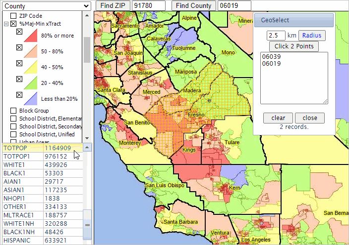
Using GeoSelect with a County Layer
In this example, the County layer in the "Base -- Majority-Minority Project" is used.
.. the county layer has been selected (top left).
.. GeoSelect is started and the Radius button is clicked.
.. click a point in Madera County; the geocode listbox populates with the Madera geocode.
.. click a second point in Fresno County; The Fresno geocode is added to the set of counties.
.. this process can continue as long as desired.
.. when done, the profile panel (lower left) shows demographic attributes for the aggregate area.
.. the total population in the aggregate area (two counties) is 1.16 million.
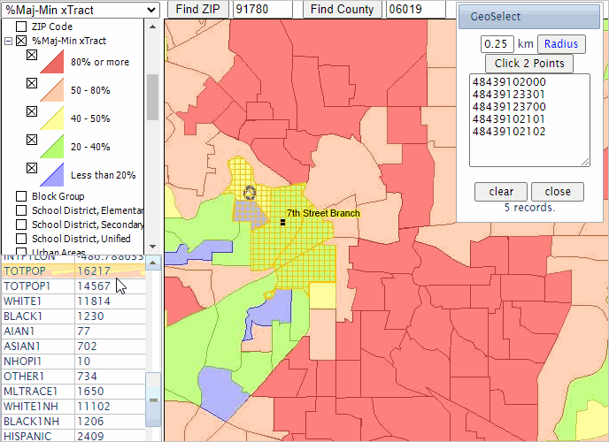
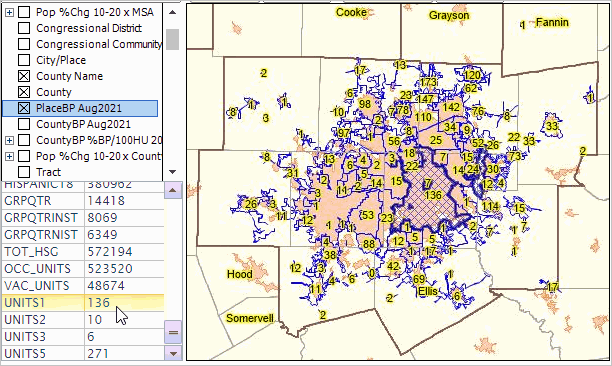
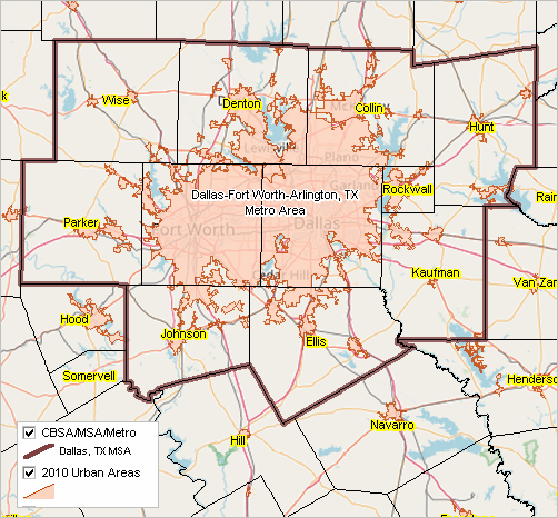
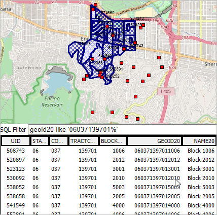
Using GeoSelect to Develop/Modify/Examine Bank Assessment/Service Areas .. GeoSelect top .. goto top
The view shown below illustrates how the GeoSelect/Site Analysis feature can be used to develop, modify or examine
assessment/service areas by selecting/aggregating Census 2020 census tracts in the vicinity of a bank location
(the 7th Street branch).
In this example, the "%Maj-Min x Tract" layer in the "Base -- Majority-Minority Project - Banks" project is used.
.. the map window shows a thematic pattern map of percent majority-majority population by tract.
.. the application is located in the Dallas metro. Click Find County with code 48349 to zoom to Tarrant County, TX
.. the profile panel at the lower left shows the aggregated demographics for the set of selected tracts.
.. the user selects the "%Maj-Min x Tract" layer as the active layer (upper left dropdown).
.. the Tools>GeoSelect is started, the popup form appears.
.. in the GeoSelect form the top left radius value is set small, 0.25 km and Radius button clicked.
.. tracts in the vicinity of the bank location are clicked, progressively.
- adding each tract geoid to the running list in the GeoSelect form.
- updating the profile panel with the cumulative demographics for the service area.
.. the process may be stopped or cleared at any time.
.. the cumulative demographics and the list of tract geoids may be copied to clipboard and saved for other use.
.. in this example, 5 tracts have been selected.
- the total population is 16,217; the White alone, non-Hispanic population is 11,102.
Find Address/Geocoding Feature .. goto top
Several methods of finding and viewing an address location in the Map Window are supported by VDA.
The simplest method is to use the Find Address feature above the Map Window.
The default value is "405 Hilgard Avenue 90095" -- the address for UCLA.
Click Find Address and the location is shown in the Map Window.
Find a Geography and Attributes
Using the Situation & Outlook project, here are some examples ... Congressional Community
.. make the Congressional Communities layer the Active Layer
.. that is, select that layer name (Congressional Communities) from the upper left dropdown.
.. next click the Find Address button .. finally click the triangle marker in the Map Window.
.. the Congressional Community code (0633012) is shown in the Profile Panel in the lower left.
Census 2020 Census Tract
.. make the Census 2020 layer the Active Layer
.. that is, select that layer name (Tract 2020 Code) from the upper left dropdown.
.. next click the Find Address button .. finally click the triangle marker in the Map Window.
.. the Census 2020 tract code (06037265301) is shown in the Profile Panel in the lower left.
School District 2020
.. make the School District 2020 layer the Active Layer
.. that is, select that layer name (School District 2020) from the upper left dropdown.
.. next click the Find Address button .. finally click the triangle marker in the Map Window.
.. the 2020 School District code (0622710) is shown in the Profile Panel in the lower left.
This method is similar to the Find Address Option 1 described below.
Additional Find Address Operations
Examining locale attributes for a Amazon Bosch TV series residential filming location: Using Find Address Blog Post
The Find Address feature determines location attributes of an address entered by the user and
shows the address location as a marker in the Map Window.
The Find Address feature can return the latitude-longitude for the address and the Census block code
(both 2010 and 2020 block codes). With the block code, the state, county and tract codes are also determined.
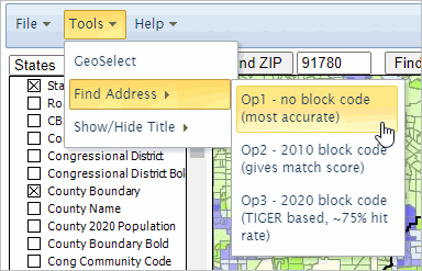
The Find Address feature is started by selecting Tools>Find Address from the Main Menu toolbar.
Benefits of Using Find Address. Why not just use Google Maps, or similar Web-based tools, to find an address? Those methods show the address
as a marker on a map. However, the map view presented by those methods do not enable the user to view/analyze related statistical/political
geography. With VDA, you choose the layers that you want to associate with addresses.
With VDA you can click that layer object (e.g., a census block) and view/access the related demographic-economic profile.
You might know the address but not the census block or census tract code or congressional community. Why not just use the Ceneus Geocoder?
One, the Census geocoder has only an approximate 75 percent hit rate. 25 percent of existing addresses might not be matchable.
That is because the Census geocoder uses TIGER which does not have comprehensive
street segment coding. Many street names or address ranges are missing.
Another limitation of the Census Geocoder is that it returns the codes, but the location is not shown in a map;
there is no direct way to link the geography with the demographics.
With VDA, you choose the layers (geography and demographic-economic attributes) that you want to associate with addresses.
Other Find Address methods may not be able to relate the address to many types of geographic areas, like congressional communities
or your customer service areas. See Find Address examples below.
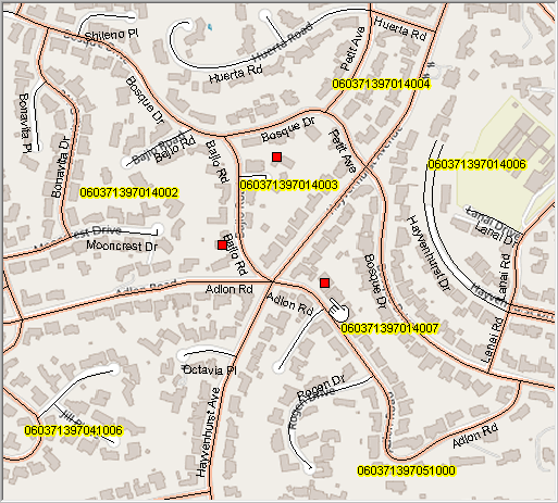
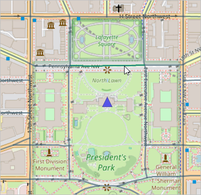
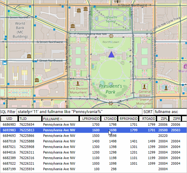
Find Address Illustrative View. An illustrative view of using Find Address Option 3:
When Find Address option 3 is used, the blue marker is displayed as shown in the map view.
- in this example, the Census 2020 block code layer is showing;
- it shows the same block code as a label in the block polygon as returned using Find Address.
- the profile panel shows the profile of the TIGER line segment matched to the address.
- the TIGER Line ID in the profile is the same as returned by the Find Address operation.
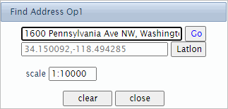
Find Address Options. There are three types of Find Address options:
• Option 1 - Basic, most accurate in general
• Option 2 - 2010 block code with match score
• Option 3 - 2020 block code Census TIGER based, overall 75% hit rate
After selecting a Find Address option, a Find Address form is shown as a pop-up in the upper right of the overall window.
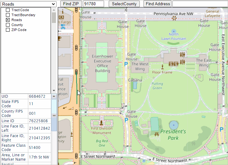
All three options operate similarly, each requiring an address to be entered as shown in the Option 1 graphic below.
- after entering address, click the Go button to locate the address.
- the default address for all options is 1600 Pennsylvania Ave NW, Washington, DC, 20502
- the Map Window refreshes with a zoom to the location and shows the location with a blue triangle marker
- the Find Address form refreshes showing attributes of the location (this varies by option selected)
- the scale setting provides a way to set the map extent for location viewing.
- in most instances 1:10000 might be preferred; 1:100000 will provide more of a zoomed-out view.
- use the clear button to set the default settings.
- use the close button to end the operation.
Find Address Option 1 - Basic, most accurate in general
This option:
- works with global addresses.
- provides most address specification flexibility; "White House" returns the same result as the default address.
- returns only the latitude-longitude on the form.
- enables to user to find a location by entering a latitude-longitude.
- click Latlon button after entering latitude-longitude in the format shown.
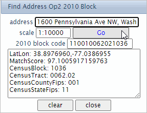
Find Address Option 2 - 2010 block code with match score
This method uses a range of address coders and select the one with best match score.
- it will generally have a higher match score than option 3.
- works with U.S. addresses only.
A structured address is required for this option:
streeetaddress,city,stusab,ZIP
- 4 commas are required.
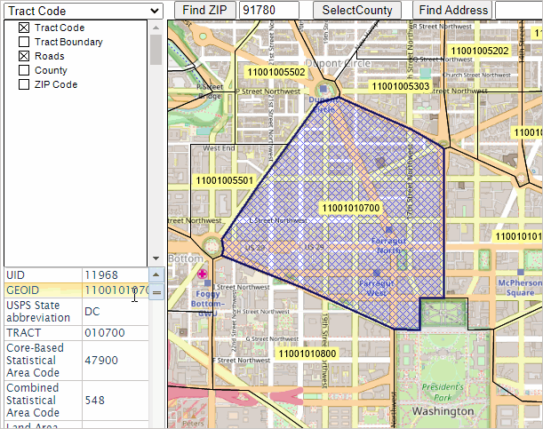
As shown in the graphic above, this option returns:
- the Census 2010 block code (15 character code).
- these attributes:
- LatLon: 38.8976960,-77.0386955
- MatchScore: 97.1005917159763
- CensusBlock: 1036
- CensusTract: 0062.02
- CensusCountyFips: 001
- CensusStateFips: 11
A match score above 90 is good; above 95 preferred; a score of 60 means it is matching to ZIP centroid.
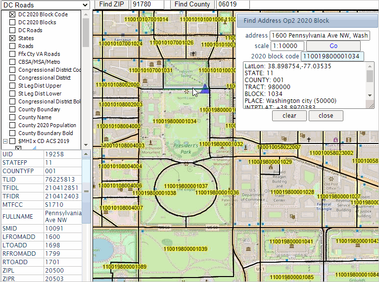
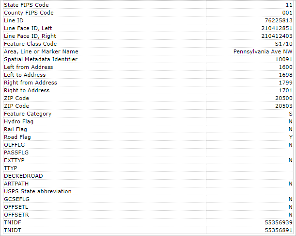
Find Address Option 3 - 2020 block code Census TIGER based, overall 75% hit rate
This method uses a range of address coders and select the one with best match score.
- it will generally have a lower hit rate (ability to find address) that option 1 or 2.
- works with U.S. addresses only.
This method is the slowest among all options.
A structured address is required for this option:
streeetaddress,city,stusab,ZIP
- 4 commas are required.
As shown in the graphic above, this option returns:
- the Census 2020 block code (15 character code).
- these attributes:
LatLon: 38.898754,-77.03535
STATE: 11
COUNTY: 001
TRACT: 980000
BLOCK: 1034
PLACE: Washington city (50000)
INTPTLAT: +38.8970383
INTPTLON: -077.0372535
AREALAND: 144892
AREAWATER: 0
Tigerline ID: 76225813
Tigerline ID: L
Find Address Examples
Example 1. What is the
Low and Moderate Income (LMI) status for a census tract containing an
address of interest? You might have many addresses where this information is needed.
With VDA, you can determine LMI status (where you have the tract layer with LMI coding) for any tract.
See your locations on a map with other relevant geography/information.
Use our LMI (and related details) for Census 2020 tracts (available December 2021).
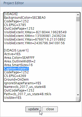
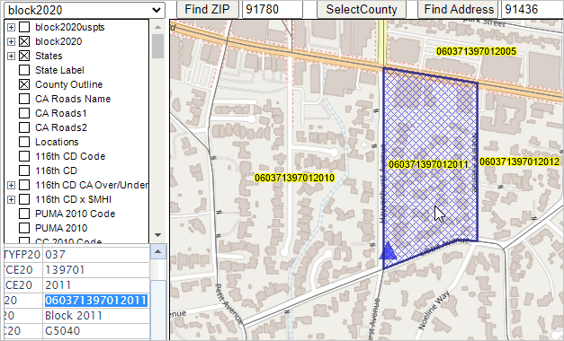
Layer Editor .. goto top
Use the Layer Editor (Editor) to set properties of the Active Layer; select by using dropdown in upper left.
Start the Editor using the main menu Tools>Layer Editor.
.. when started, the Editor form is shown.
.. click the Back button to return to main user interface with no changes.
.. click set & close button to adopt settings.
Changes made to the project using the Editor are not automatically saved.
The purpose of the Editor is to change the appearance of how the layer is rendered/shown in the map window.
Examples:
• add, remove, change or modify appearance of a label.
• modify the style of the boundary/outline.
• place a query on a layer to show only shapes meeting a certain criteria.
The Editor form consists of three sections:
• General - where a query is set on the layer.
• Object attributes - settings for a marker, line or polygon.
.. the layer is comprised of obects of one of these types.
• Label attributes -- settings for optional use of a label.
Example: adding/setting a label.
In this example the Arizona SRDMI project is used.
The start-up active layer is Congressional Communities (CCs).
Check-on the Congressional Communities layer in legend panel to show CC boundaries.
.. there is no start-up label.
Start the Editor to add a label -- main menu Tools>Layer Editor.
In the Label section,
.. set Visible to True
.. set Fieldname to CCN20
Click Set & Close button
CCs are now labeled with CCN20 values.
Using the similar Nevada SRDMI project.
The start-up active layer is Congressional Communities (CCs).
End of this topic .. goto top Uploading Layers & Integrating Data .. Level 2 feature .. goto top
Add your own shapefile/data to an existing project to view/analyze your data with other existing layers/data.
Analytical opportunities are unlimited!
Use any existing project to upload layers.
With project open, use File>Upload Layer and proceed as illustrated in the following examples.
This section shows how to add 2020 TIGER detailed roads ("edges") for a county.
Los Angeles County, CA is used here as an example. There are 394,798 detailed road segments in Los Angeles County, CA based on the 2020 TIGER edges shapefile.
Typically these are intersection to intersection, but often comprised of shorter connected segments.
Step 1. Extract the Los Angeles County, CA (06037) edges shapefile to c:\vdauploads
.. it is suggested that all VDA upload files be kept in one folder, such as C:\vdauploads, and not contain other files.
Note: get the edges shapefile for any county from this set of links.
.. the counties are organized by state+county FIPS code
.. to use another county, replace 06037 in the following the state+county edges file that is downloaded.
Step 2. Delete all unzipped files in c:\vdauploads except these:
tl_2020_06037_edges.shp
tl_2020_06037_edges.shx
tl_2020_06037_edges.dbf
Step 3. Develop the INI file
Copy the 11 lines below, paste into Notepad (any text editor) and save as c:\vdauploads\tl_2020_06037_edges.shp.ini
.. when uploading a file that has large, detailed objects displayed, set Active=NO
.. otherwise set Active=YES
.. if Active=No, the layer will show as unchecked and not display in the Map Window
.. the spelling/characters used in file names must match exactly.
.. the Los Angeles County roads (edges) shapefile has state county code 06037
Step 4. Zip (for example using Winzip) these four files to the new file c:\vdauploads\tl_2020_06037_edges.zip
Step 5. With VDA running, use File>Upload Layer from the Main Menu bar to start the upload. The upload form appears:
The above view shows that the user chose the file c:\vdauploads\tl_2020_06037_edges.zip.
The final step is to click the "upload and write to project" button. A zip file of this size (~50MB) may require several minutes to complete; wait for a message and do not click upload again
Close the upload form when done.
The following view shows the "06037 Roads".
To obtain a view similar, click Find ZIP with the ZIP code set to 90068.
Then check the "06037 Roads" layer box in legend panel to show streets/roads.
Zoom-in View
The zoom tools could be used to "manually" zoom to an area of interest. Here the Find Address feature is used.
The Find Address feature is used to locate, zoom to and place a marker in the map view for the address
7207 Woodrow Wilson Dr, Los Angeles, CA 90068, a filming location used in the
the Amazon Bosch TV series
as shown in the following graphic.
Notes on Viewing/Using the Street Segments
Proceeding from the above view, a profile of the street segment containing an address of interest is obtained as follows:
.. make the "06037 Roads" layer active.
.. click the street segment by the address location marker.
.. the street segment is selected and highlighted green as ahown in the above graphic.
.. the street segment attributes are shown in the Profile Panel at lower left.
.. note that this address is on/adjacent to TLID (TIGER Line ID) 692806227
-- a unique ID among all road segments in the U.S.
.. the address range of the left and right side of the road segment ar also shown.
.. see related details about using the TIGER edges files.
Step 6. Optionally save the updated project with existing or as a new name.
This section shows how to upload Census 2020 TIGER census blocks for a county (Fresno County, CA)
Step 1. Extract the Fresno County, CA (06019) tabblock shapefile to c:\vdauploads
.. it is suggested that all VDA upload files be kept in one folder, such as C:\vdauploads, not containing other files.
Note: get the 2020 census block shapefile for any county from this set of links.
.. the counties are organized by state+county FIPS code
.. to use another county, replace 06059 in the following the state+county blocks file that is downloaded.
Step 2. Delete all unzipped files in c:\vdauploads except these:
tl_2020_06019_tabblock20.shp
tl_2020_06019_tabblock20.shx
tl_2020_06019_tabblock20.dbf
Step 3. Develop the INI file
Copy the 18 lines below, paste into Notepad (any text editor) and save as c:\vdauploads\tl_2020_06019_tabblock20.shp.ini
.. the spelling/characters used in file names must match exactly.
.. the Fresno County 2020 census blocks (tabblock20) shapefile has state county code 06019
.. choose a different county such as 11001 (Washington, DC)
Step 4. Zip (for example using Winzip) these four files to the new file c:\vdauploads\tl_2020_06019_tabblock20.zip
Step 5. With VDA running, use File>Upload Layer from the Main Menu bar to start the upload. The upload form appears:
The above view shows that the user chose the file c:\vdauploads\tl_2020_06019_tabblock20.zip
The final step is to click the "upload and write to project" button
.. wait for a message and do not click upload again
Close the upload form when done. The initial view is shown below.
Step 6. Optionally save the updated project with a new name
This section shows how to upload the 2020 TIGER water areas for a county (Orange County, FL)
Step 1. Extract the Orange County, FL (12095) tabblock shapefile to c:\vdauploads
.. it is suggested that all VDA upload files be kept in one folder, such as C:\vdauploads, that does not contain other files.
Note: get the 2020 water areas shapefile for any county from this set of links.
.. the counties are organized by state+county FIPS code
.. to use another county, replace 06059 in the following the state+county blocks file that is downloaded.
Step 2. Delete all unzipped files in c:\vdauploads except these:
tl_2020_12095_areawater.shp
tl_2020_12095_areawater.shx
tl_2020_12095_areawater.dbf
Step 3. Develop the INI file
Copy the 18 lines below, paste into Notepad (any text editor) and save as c:\vdauploads\tl_2020_12095_areawater.shp.ini
Active=YES
Area.Color=$FF8080
Area.OutlineColor=BLUE
Area.OutlineWidth=2
Area.SmartSize=16
Caption=12095 Warer Areas
CodePage=1252
CS.EPSG=4269
Ground=OnDem
IgnoreShapeParams=YES
Name=12095 water areas
OutCodePage=1252
Path=tl_2020_12095_areawater.shp
Visible=YES
.. the spelling/characters used in file names must match exactly.
Step 4. Zip (for example using Winzip) these four files to the new file c:\vdauploads\tl_2020_12095_areawater.zip
Step 5. With VDA running, use File>Upload Layer from the Main Menu bar to start the upload. The upload form appears:
The above view shows that the user chose the file c:\vdauploads\tl_2020_12095_areawater.zip
The final step is to click the "upload and write to project" button
.. wait for a message and do not click upload again
Close the upload form when done. The initial view is shown below.
This view shows both the linear water and area water layers.
Step 6. Optionally save the updated project with a new name
This section shows how to upload the 2020 TIGER water areas for a county (Orange County, FL)
Step 1. Extract the Orange County, FL (12095) tabblock shapefile to c:\vdauploads
.. it is suggested that all VDA upload files be kept in one folder, such as C:\vdauploads, that does not contain other files.
Note: get the 2020 linear water shapefile for any county from this set of links.
.. the counties are organized by state+county FIPS code
.. to use another county, replace 06059 in the following the state+county blocks file that is downloaded.
Step 2. Delete all unzipped files in c:\vdauploads except these:
tl_2020_12095_linearwater.shp
tl_2020_12095_linearwater.shx
tl_2020_12095_linearwater.dbf
Step 3. Develop the INI file
Copy the 18 lines below, paste into Notepad (any text editor) and save as c:\vdauploads\tl_2020_12095_linearareawater.shp.ini
Active=YES
Caption=12095 Linear Water
CodePage=1252
CS.EPSG=4269
Ground=OnDem
IgnoreShapeParams=YES
Line.Color=BLUE
Line.OutlineColor=BLUE
Line.SmartSize=16
Line.Width=2
Name=12095 linearwater
OutCodePage=1252
Path=tl_2020_12095_linearwater.shp
Visible=YES
.. the spelling/characters used in file names must match exactly.
Step 4. Zip (for example using Winzip) these four files to the new file c:\vdauploads\tl_2020_12095_linearwater.zip
Step 5. With VDA running, use File>Upload Layer from the Main Menu bar to start the upload. The upload form appears:
The above view shows that the user chose the file c:\vdauploads\tl_2020_12095_linearwater.zip
The final step is to click the "upload and write to project" button
.. wait for a message and do not click upload again
Close the upload form when done. The initial view is shown below.
This view shows both the linear water and area water layers.
Step 6. Optionally save the updated project with a new name
This section shows how to upload the 2020 TIGER VTDs/Precincts for a county (Westchester County, NY)
It is suggested that the Base - Majority-Minority Tracts project be used.
VOTING DISTRICTS
Voting district is the generic name for an area, such as a precinct or ward that is established
by state and local governments for purposes of elections. States participating in the 2020
Census Redistricting Data Program provided the Census Bureau with boundaries, codes, and
optional names for their voting districts. The voting district code is a six-character field that
may contain any ASCII character.
Voting District Indicator
States participating in the 2020 Census Redistricting Data Program have the option to indicate
whether the voting district boundaries they submitted to the Census Bureau are "pseudo" or
"actual." Pseudo voting districts are those that were approximated. These approximated voting districts are represented in the voting district indicator field as a “P.†Actual voting districts represent ground truth and are represented in this field as an “A.†Actual voting districts
are additionally identified by an asterisk (*) appended to the voting district name in the Area
Name-Legal/Statistical Area Description (LSAD) Term-Part Indicator. If a state did not provide
voting districts for a county, this field is blank.
Step 1. Extract the Westchester County, NY (36119) VTD shapefile to c:\vdauploads
.. it is suggested that all VDA upload files be kept in one folder, such as C:\vdauploads, that does not contain other files.
Note: get the 2020 VTD shapefile for any county from this set of links.
.. the counties are organized by state+county FIPS code
.. to use another county, replace 36119 in the following the state+county file that is downloaded.
Step 2. Delete all unzipped files in c:\vdauploads except these:
tl_2020_36119_vtd20.shp
tl_2020_36119_vtd20.shx
tl_2020_36119_vtd20.dbf
Step 3. Develop the INI file
Copy the 18 lines below, paste into Notepad (any text editor) and save as c:\vdauploads\tl_2020_36119_vtd20.shp.ini
.. the spelling/characters used in file names must match exactly.
Step 4. Zip (for example using Winzip) these four files to the new file c:\vdauploads\tl_2020_36119_vtd20.zip
Step 5. With VDA running, use File>Upload Layer from the Main Menu bar to start the upload. The upload form appears:
The above view shows that the user chose the file c:\vdauploads\tl_2020_36119_vtd20.zip
The final step is to click the "upload and write to project" button
.. wait for a message and do not click upload again
Close the upload form when done. To obtain a view similar to the one shown below, navigate to Westchester County.
.. in the legend panel at left, uncheck %Maj-Min x Tract layer.
- uncheck World by Country layer.
- check on the OpenStreetMaps layer.
.. in top left dropdown, select the Westchester County layer (makes it the active layer).
.. enter the stcty code for Westchester County (36119) in the Find County edit box above the map window.
.. click Find County button.
.. position pointer in cross-hatched VTD in view below & click on that VTD.
- Profile panel in lower left populates with attributes of this VTD.
Step 6. Optionally save the updated project with a new name
This section shows how to upload the most recent U.S. national scope FDIC Summary of Deposits data for financial institutions and branch locations.
Details in this section are a little different that other upload sections.
Use the existing VDA project "Base - Majority-Minority Tracts - Banks" to view/examine bank locations in context of majority-minority tracts.
This is an illustrative project; add other banks; use ofther geography/data.
About the data. This project includes all 2021 FDIC banks and banking locations with integrated "summary of deposits" data.
The project also includes all/national scope Census 2020 census tracts with associated Census 2020 demographics.
The FDIC bank data used here contains the subject matter described here (xls).
Overall features of these data include: 4,941 institutions,
83,991 insured branch offices,
$22,877 billion $USD total assets,
$18,771 billion $USD total deposits.
The analytical concept behind use of these data is to provide a resource to 1) visually/geographically compare one set of bank locations with others,
2) use SQL queries and dynamically compute values in table/query grid and/or
3) examine a set of banks in context of small area/market demographics.
It is recommended that the uploaded shapefile be added to the "base_mmtracts" project.
This project includes a 2020 tracts layer with showing patterns of Census 2020 percent majority-minority population.
Step 1. Download the FDIC Banks 2021 upload file
to c:\vdauploads
.. download this file to your computer where it is then uploaded to the VDA server (step 2 below).
.. this is a dropbox location and requires a password provided separately
.. when the dropbox screen appears, click the download button (button at far right)
- download the zip file as one file, not unzipped files.
.. all VDA upload files should be kept in one folder, such as C:\vdauploads, that does not contain other files.
Step 2. With VDA running, use File>Upload Layer from the Main Menu bar to start the upload. The upload form appears:
The above view shows that the user chose the file c:\vdauploads\fdic2021pts.zip (this is the file downloaded from dropbox).
The final step is to click the "upload and write to project" button
.. wait for a message and do not click upload again
Close the upload form when done.
The objective view shown below. Bank locations are included for two banks (California & Texas).
See query notes below.
An easy way to navigate to the specific banking area is to use the Find County above the map window.
.. use county code 06019 (Fresno County) for Calfornia central valley area.
.. use county code 48113 (Dallas County) for Dallas metro area.
A zoom-out/some navigation is required to see all locations for a bank (black square markers with branch name as label).
Step 4. Optionally view bank branches in table/grid format:
Step 5. Optionally save the updated project with a new name.
Modify Bank Selection
Use your own banks of interest. Find a bank using this search tool.
.. on the bank profile, see the bank "FDIC Cert #"
Modifying the INI file with a different bank/Cert #
The INI file that specifies the start-up values for viewing of this layer is shown below.
This INI specifies that :
.. Label.Field=namebR sets label used for each object (bank locations) as the branch name field.
- change label by setting label parameter to any field in the dataset.
.. Query=CERT='23030' sets visible objects (bank locations) to those with FDIC certification code as 23030.
- change bank by setting query setting to any bank cert code.
Project Editor .. Level 3 feature .. goto top
The Project File contains configuration data for the project referenced.
.. sometimes referred to as an INI file, it controls the way SQLite files are rendered in the Map Window at startup.
The Project Editor enables the user to modify and save the project file for any existing VDA project.
Start the Project Editor using the main menu File>Project Editor.
The Project Editor form then appears populated with content of the project file for the currently active project.
Using the "Base" project, the form appears as shown below.
There are two basic steps to using the Project Editor:
.. 1) make changes in Editor text section; 2) Click update button.
As an example, you might want to change the "Caption" of the layer presently shown as "States1" to "StatesBase"
.. see highlighted in above graphics.
You would make that change to that text showing in the Project Editor form, then click "Update Project button.
.. the project is saved in a temporary mode and the Legend and Map Window refresh.
If the project appears as desired, use the File>Save to permanently save the project.
Project File
Project File content must adhere to strict rules. One invalid character can render the project unusable.
.. the file contains only text characters.
.. the file has a top section; layers section and possibly layer/intervals section.
.. top section has overall project attributes.
.. layers section contains several attribute and their settings for each layer.
.. layer/interval sections contains "additional" interval settings for layers where applicable.
.. layers are numbered in the layer file. Numbering is sequential and cannot be modified in general,
.. layers are presented in "reverse order" compared to way presented in the Legend Panel.
Project File parameters and their usage will be provided in an updated version of this document.
Using the Project Editor with Base-Housing Project .. goto projecteditor top .. goto top
In this example, the "PlaceBP Aug2021" layer in the "Base-Housing" project is modified.
The "PlaceBP Aug2021" portion of the project file is edited to display the August 2021 building permits as a label in the map view.
These are monthly permit issuing places in the Dallas, TX metro. This graphic shows the resulting view, places with blue boundary labeled with the number of
building permits issued in context of the urban areas (salmon fill pattern). The Dallas city area (crosshatched) is clicked and shows a profile for the
place in the Profile Panel (lower left). As shown in the profile and in the map view, there were 136 single family unit permits issued in August 2021.
To develop the above view, the Project Editor is used to modify the settings for the "PlaceBP Aug2021" layer in the "Base-Housing" project.
The Editor is started; the portion of the project file relating that layer is shown in the upper portion of the following scroll section (Before).
The edited portion of the project file is shown further down (After). Note that this text section relater to "[VDAGIS Layer14]".
The "Before" differs from the "After" by adding the lines/setting highlighted in red to the "After". The above map view displays after the
Update button is clicked in the Project Editor form.
Using the Project Editor with Base-Majority-Minority-Banks Project .. goto projecteditor top .. goto top
In this example, the "Bank Locations FDIC 23474" layer in the "Base-Majority-Minority-Banks" project is modified.
Use your own banks of interest. Find a bank using this search tool.
.. on the bank profile, see the bank "FDIC Cert #"
To develop the above view, the Project Editor is used to modify the settings for the "PlaceBP Aug2021" layer in the "Base-Housing" project.
The Editor is started; the portion of the project file relating that layer is shown in the upper portion of the following scroll section (Before).
The edited portion of the project file is shown further down (After). Note that this text section relater to "[VDAGIS Layer14]".
The "Before" differs from the "After" by adding the lines/setting highlighted in red to the "After". The above map view displays after the
Update button is clicked in the Project Editor form.
Using the Table/Query Operations .. goto top
The Table/Query operations differ from the Find ZIP/Find County navigation tools reviewed above.
The Table/Query feature enables viewing/processing the attribute data for a selected layer in a tabular/grid form.
This feature enables the user to do these things:
• view all fields of the selected layer in a tabular form.
• sort tabular data in grid on any column/field.
• perform a query on tabular data/grid to view only selected rows (geographic objects).
• click a row in grid to select that item then click "click geography row to display".
.. Map Window refreshes with zoom to that geography.
• output data in CSV or other format.
Using Table/Query
• to start Table/Query, click the Table/Query button below the Map Window at right (see graphic).
• with the full Map Window displayed, clickin the Table/Query toggle button splits what was the Map Window.
.. it becomes a split Map Window and Table Grid as shown below.
• the Table/Query button is a toggle operation; click it again and the grid is removed.
If you are using the "Census 2020" project (or any project where the "States" layer is the top layer), the default overall display will appear as shown here.
Using the Table/Query Query Operations
There are two queries that can be performed on/filter the grid:
• One Item
.. set an arithmetic or logical condition on a selected field in Active Layer
.. field name selected in left dropdown.
.. logical/arithmetic condition set in center dropdown.
.. criteria value set in right edit box.
.. click query button to perform filter operation on grid.
• VDA SQL
.. use a combination of fields and conditions based fields in Active Layer
.. use parentheses and nested conditions.
.. criteria value set in right edit box.
.. click query button to perform filter operation on grid.
Refreshing the Table Content
After a query has been performed, only those records meeting the criteria appear in the grid.
To reset/refresh the grid, so that it shows all records/rows, use the query UID > 0
.. The UID is the "unique identifier for current shape/geographic object".
.. The UID appears as the leftmost column in the grid.
The UID is the sequential number of the row in the file. UID > 0 will show all records.
Copying Rows from Grid for External Use
To copy rows from the grid (click on one row or multi-select), right click the blue highlighted area, copying to clipboard.
Ctrl-V to paste in an open editor or worksheet in another program/application.
To copy the header/field names,
.. click an object in the Map Window, the profile appears in the Profile panel.
.. click the copy to clipboard button below the panel.
.. Ctrl-V paste into a spreadsheet.
.. copy the first column cells and paste special>transpose into the first row of the spreadsheet.
.. from the grid, select the rows of interest and Ctrl-V into cell A2 of the spreadsheet.
Handling Text Fields with Lead-zeroes
Many fields in layers are geography codes with lead zeroes. The lead zeroes need to be retained when pasting into a spreadsheet.
To accomplish this, before proceeding as described above, follow these steps:
.. select the cells that will hold the data you are going to paste.
.. display the Home tab of the Excel ribbon.
.. click the small icon at the lower-right corner of the Number group.
.. Ctrl-V the rows copied to clipboard from grid.
Example: Using the Table/Query with Congressional Communities
The following graphic illustrates using the Congressional Communities (CC) layer in the "census 2020" project.
• this view shows a row in the grid for each CC in congressional district "0648" -- California 48.
• after the query was applied, the number of rows, CCNs, meeting the criteria is shown as 15 below the table.
• after the query was applied, the row with CCN 0648007 was clicked in grid.
• next, the "click geography row to display" button below grid was clicked.
.. the Map Window refreshes with a zoom to that CCN.
Steps to obtain this view, assuming start-up using Census 2020 project:
• select CC 2010 as selected/Active Layer using top left dropdown.
• in legend panel click CC 2010 checkbox on
• click Table/Query toggle button.
• set basic query CCN (the field to match on), begin (indicates first few characters in criteria must match), 0648 (no quotes).
• click query button.
• to zoom to a selected CCN, click that row in the grid.
GIS Projects & Project Management .. goto top
The following summarizes basic procedures to upload a CV XE GIS project for use with the VDA3 Web GIS.
These steps make use of the "base.gis" project included with CV XE GIS installer.
It is recommended that users follows these steps, actually using the base.gis project for first time upload.
As described elsewhere, the purpose/role of the base.gis project is to provide a "basic" starter project that users
can easily build on by adding their own shapefiles/layers. Those topics are reviewed in the CV XE GIS user guide.
This procedure requires CV XE GIS Level 1 or higher. The steps below should be followed exactly.
On the computer where CV XE GIS is installed ...
1. Create a new folder: c:\gisbase
2. With CV XE GIS running, use File>Open>Dialog and open c:\cvxe\1\base.gis
3. Use File>Package GIS Project .. on form that appears
3.1. set the edit box value to "c:\gisbase\base.zip" (no quotes)
3.2. click "ZIP to" button and wait for confirming reply (less than a minute)
3.3. CV XE GIS can be optionally closed.
4. unzip "c:\gisbase\base.zip" (no quotes) to "c:\gisbase\" (no quotes)
4.1. verify the files are in "c:\gisbase\" (no quotes) and not in a subfolder.
4.2. make the folder "c:\gisbase\out"
5. run the utility tcSHP2SQLITE.exe from the command prompt (included with CV XE GIS installer)
5.1. run c:\cvxe\tcSHP2SQLITE.exe. In the form that appears:
5.2. enter "c:\gisbase" in the "from" edit box.
5.3. enter "c:\gisbase\out" in the "to" edit box.
5.4. click the convert button, wait for notification, close that application.
5.4.1. close the tcSHP2SQLITE program.
6. copy "c:\gisbase\base.gis" to c:\gisbase\out
7. copy "c:\gisbase\mapquest openstreetmaps tiles.ttkwp" to c:\gisbase\out
Ready for upload ...
1. Start VDA3 and login.
2. After login, use the section "Register a Project"
3. Click the Choose File button
3.1. Select the file "c:\gisbase\out\base.gis" (no quotes)
4. Enter a Project Code value
5. Enter a Project Name value
6. Click the upload and register
7. The project name now shows as available. Select it and click Select button to open.
Examining Metro-Urban Area Characteristics .. goto top Metropolitan Statistical Areas (MSAs) and
corresponding Urbanized Areas are both areas having 50,000 or more population.
There is always one or more Urbanized Area(s) intersecting with an MSA. They relate in important ways, overlap and are defined in different ways.
An MSA is a set of contiguous counties. A Census 2010 Urbanized Area (UA) has 50,000 or more people
and an Urban Cluster (UC) must have at least 2,500 and less than 50,000 people. Urban areas are comprised of a set of census blocks.
The VDA "Base" project provides a layer with Census 2020 vintage
metros and Census 2010 vintage Urban Areas.
Create views like shown below for urban areas of interest in context of other geographic areas using VDA Web GIS.
This graphic shows urban areas in context of the Dallas MSA.
Steps to develop similar views using VDA
With the "Base" project open, follow these steps.
• enter state-county code 48113 (Dallas County) in the Find County box above map window.
.. later, use any county of interest; get state+county code from this list.
.. click Find County button; the map view refreshes with a zoom-in to the selected county
• in the legend panel:
.. uncheck the "Pop %Chg 10-20 x County" layer
.. check the "CBSA/MSA/Metro" layer on
.. check the "MSA Name" layer on
.. check the "County" layer on
• navigate using Zoom window tool
.. Zoom out, a little, to see the entire metro .. similar to the above view
Geometry is represented in VDA in these structures (many others are possible):
• SQLite point files, such as schools
• SQLite line files, such as roads
• SQLite polygons, such as states
• Tiling Raster Graphics, topology; land coverage
The above geography data are organized into VDA GIS projects.
Real-time Geographic Area Computation .. goto top
Clicking a geographic object in the Map Window displays attributes of that object for the Active Layer
(e.g., census tract) in the Profile Panel (lower left).
For polygons, the area of the object is computed real time and displayed in the last/bottom field in the profile.
The area is presented with the name VDA_Area and displayed in square meters.
Using square meters enables accurate computation for any size geography.
It also provides a standardized measurement unit across all types of source geography.
Compute square miles by dividing the square meters value by 2589988.
Availability of the geographic area enables easy computation of per capita measures for any appropriate measure or attribute
for any polygon area.
VDA projects use Census-sourced TIGER files, among other types of geometry, described below.
TIGER/DMD .. goto top
TIGER (Topologically Integrated Geographic, Encoding & Reference), or TIGER/Line,
is an annually updated Census Bureau public domain geographic database.
See more about
TIGER and related
technical documentation.
VDA SQLite Files & TIGER
Where used in VDA projects TIGER shapefiles ..
• are converted to SQLite structure.
• almost always include integrated subject matter not part of the original shapefile.
• are often modified with respect ot original attributes/fields included.
Datum (GCS NAD 83)
Each TIGER shapefile contains a project (.prj) file that contains the GIS industry standard well-known text (WKT)
format to describe the coordinate system, projection, datum information for each shapefile. All Census
Bureau generated shapefiles are in Global Coordinate System North American Datum of 1983 (GCS
NAD83). Each .prj file contains the following:
GEOGCS["GCS_North_American_1983",DATUM["D_North_American_1983",SPHEROID["GR
TIGER Usage in VDA. Many of the VDA GIS projects make use of TIGER-sourced shapefiles and related data.
Shapefiles are digital representations of geographic features (e.g., lakes, landmarks, roads, and
boundaries) used to create maps. A shapefile stores non-topological geometry and attribute information
for the spatial features in a data set. In general, TIGER-sourced shapefiles contain only geographic data and
no demographic or subject matter data.
Legal Entities (boundary shapefiles) .. goto TIGER Files
• American Indian Off-Reservation Trust Lands
• American Indian Reservations – Federal
• American Indian Reservations – State
• American Indian Tribal Subdivisions (within legal American Indian areas)
• Alaska Native Regional Corporations
• Congressional Districts – 116th Congress
• Consolidated Cities
• Counties and Equivalent Entities (except census areas in Alaska)
• Estates (U.S. Virgin Islands only)
• Hawaiian Home Lands
• Incorporated Places
• Minor Civil Divisions
• School Districts – Elementary
• School Districts – Secondary
• School Districts – Unified
• States and Equivalent Entities
• State Legislative Districts – Upper
• State Legislative Districts – Lower
• Subminor Civil Divisions (Subbarrios in Puerto Rico)
Statistical entities (boundary shapefiles) .. goto TIGER Files
• Alaska Native Village Statistical Areas
• American Indian/Alaska Native Statistical Areas
• American Indian Tribal Subdivisions (within Oklahoma Tribal Statistical Areas)
• Block Groups
• Census Areas
• Census Blocks
• Census County Divisions (Census Subareas in Alaska)
• Unorganized Territories (statistical county subdivisions)
• Census Designated Places (CDPs)
• Census Tracts
• Combined New England City and Town Areas
• Combined Statistical Areas
• Metropolitan and Micropolitan Statistical Areas and related statistical areas
• Metropolitan Divisions
• New England City and Town Areas
• New England City and Town Area Divisions
• Oklahoma Tribal Statistical Areas
• Public Use Microdata Areas (PUMAs)
• State Designated Tribal Statistical Areas
• Tribal Designated Statistical Areas
• Urban Areas
• ZIP Code Tabulation Areas (ZCTAs)
Features (points and lines shapefiles) .. goto TIGER Files
• All Lines (Edges) -- derivation of intersection to intersection roads
• Address Range-Feature
• All Roads
• Area Hydrography
• Area Landmark
• Coastline
• Linear Hydrography
• Military Installation
• Point Landmark
• Primary Roads
• Primary and Secondary Roads
• Topological Faces (polygons with all geocodes)
Relationship Files .. goto TIGER Files
• Address Range-Feature Name
• Address Ranges
• Feature Names
• Topological Faces – Area Landmark
• Topological Faces – Area Hydrography
• Topological Faces – Military Installations
Examining ZIP Code - Census Tract Relationships .. goto top
Use VDA Web GIS with the ZIPCode-Census Tract project to visualize what tracts intersect with what ZIPs.
End of this topic .. goto top Examining Housing Price Appreciation by Metro .. goto top
Use VDA Web GIS with the MetroDynamics project to examine housing prices, appreciation by metro
The Housing Price Index (HPI) is estimated/updated quarterly by metro based on Fannie Mae and Freddie Mac data,
forming a quarterly time series for most of 373 metros.
The metro HPI data have 1995Q1 as the base year/quarter (HPI=100).
These data are integrated into the MetroDynamics database.
See more about the HPI.
Application 1 ..
The following graphic, generated by VDA, shows metros color-coded by percent change in the HPI over the year,
2021Q3 to 2022Q3, in the map. Below the map is a table showing a list of selected fields where the HPI YoY percent
is greater than 21, sorted on the HPIYoYP value. This illustrative graphic can be prepared with many variations.
End of this topic .. goto top Mapping Census 2020 Blocks with Geocode .. goto top
Use VDA Web GIS with the Census 2020 Blocks project to find and examine census blocks.
Only using VDA Web GIS with the Census 2020 Blocks project can you locate a
Census 2020 block map and geocode for
a specific address .. among the universe of more than 8 million census blocks covering the U.S. wall-to-wall.
Application 1 .. Find Census Block based on Address
Create the following graphic live using the VDA Census 2020 Blocks Project.
This graphic shows 3 geocoded addresses (red markers) in context of Encino (Los Angeles) area, CA
Census 2020 blocks (orange boundaries labeled with 15 character Census 2020 block code), streets and
topology base layer.
Follow these steps:
Start VDA Web GIS -- https://vdagis.com
Next, select the Census 2020 Blocks Project
After VDA map interface displays, proceed as follows:
The map display shows the southern California area.
In the upper left dropdown, select the census2020 blocks layer as the active layer
Key in an address in the Find Address edit box above map window; click Find Address button.
.. to follow illustrative view (above), use address as simply the 5-digit ZIP Code 91436.
.. map refreshes with zoom-in view.
In the Legend Panel at left,
.. check on the blocks2020 layer
.. uncheck the Tracts 2010 $MHI layer
Zoom-in to blue marker
Click blue marker; block polygon (060371397012011) crosshatches .. the block for the center of ZIP 91436.
.. to be rooftop accurate, use the exact street address.
Application 2 .. Examining Geocoded Address Locations in Context of Census Blocks
Examining 2022 FDIC Banks .. goto top
Use VDA Web GIS with the MetroDynamics project to find and examine 2022 FDIC [insured] Banks
The Federal Deposit Insurance Corporation (FDIC) releases an annual summary of deposits file that includes data
for all FDIC insured financial institution locations (approximately 79,000) and attributes.
The year ending June 30, 2022 data were released in
September 2022 and are the basis for the "Banks" layer included in the MetroDynamics project. We augment those data
to improve consumability and analysis. We add other data to those base data including data from the FDIC Community Banks resource.
See related section http://proximityone.com/fdicbanks.htm.
This section illustrates how to use VDA to examine these data for a selected banking institution,
Westamerica Bank based in
San Rafael, CA. Similar analyses can be performed for any FDIC banking institution.
Application 1 ..
Follow these steps:
Start VDA Web GIS -- https://vdagis.com
Next, select the MetroDynamics Project
After VDA map interface displays, proceed as follows:
Click the Query/Table button below the map to the right.
.. the view refreshes showing a row for each block group.
Key in the query (copy and paste the following line into the SQL Edit box):
select geoid, pop20 where (100*(F7074A20+F7579A20+F8084A20+F85UPA20+M7074A20+M7579A20+M8084A20+M85UPA20)/TOTPOPA20)>50 and geoid like '12071%'
.. key in POP20 desc in the sort edit box and click Query button to right.
select namebr,brnum,citybr,depsumbr,depdom where cert='3430'
End of this topic .. goto top Naturally Occurring Retirement Communities .. goto top
Use VDA Web GIS with the MetroDynamics project to find and examine Naturally Occurring Retirement Communities (NORCs)
See related Web section.
Naturally Occurring Retirement Communities are geographic areas containing high concentrations of older age population.
This section reviews use of VDA Web GIS to locate block groups
in Lee County, FL.
Any geographic level (e.g., ZIP codes, census tracts, census blocks ...) could be used.
Follow these steps:
Start VDA Web GIS -- https://vdagis.com
Next, select the MetroDynamics Project
After VDA map interface displays, proceed as follows:
Click the Query/Table button below the map to the right.
.. the view refreshes showing a row for each block group.
Key in the query (copy and paste the following line into the SQL Edit box):
select geoid, pop20 where (100*(F7074A20+F7579A20+F8084A20+F85UPA20+M7074A20+M7579A20+M8084A20+M85UPA20)/TOTPOPA20)>50 and geoid like '12071%'
.. key in POP20 desc in the sort edit box and click Query button to right.
.. the query says "show me BGs in Lee County, FL that have more than 50 percent of the population that is 70 years of age and over."
.. there are 75 BGs now showing in table (see number/count 75 in lower left below table).
age groups, demographic criteria, threshold, and geography are examples and could be set/selected differently.
.. note the table now shows the BG code and the total population(Pop20), sorted on Pop20.
Click the button below the grid "Highlight all that Meet Query"
.. the map view now shows all selected BGs in the table as selected (cross-hatched) in the map window.
The following view shows a map view of the BGs meeting the criteria.
A partial list of the BGs are listed in the table below the map.
End of this topic .. goto top Find & Examine a Congressional Community .. goto top
Use VDA Web GIS with the MetroDynamics project to find and examine a congressional community (CC).
See related Web section.
Note: this section and the MetroDynamics project includes 2020 CCs only for the state of Californis at this time.
There are four illustrative applications in this section.
Congressional Communities (CCs) are geographic areas that subdivide
congressional districts.
CCs have been developed by the Congressional Communities organization
to meet their mission: helping Americans make their voices heard and
bridge the divide between us & Congress.
Application 1 .. find and examine a Congressional Community
Follow these steps:
Start VDA Web GIS -- https://vdagis.com
Next, select the MetroDynamics Project
After VDA map interface displays, proceed as follows:
Select the "Cong Community CA" layer in the upper left dropdown (making the "active" layer)
Find a CC .. click the Find Address button above the map window (for now use the default address)
.. the map window refreshes with a zoom to that location and shows a marker -- the UCLA campus in Los Angeles.
In the Legend Panel at left click on the Cong Community CA layer
.. the map now shows CC boundaries.
Click the marker (click Find Address button again if necessary)
.. a profile displays for this CC in the lower left panel.
.. see in the profile that this is CC 0636016 (CC 16 in State 06 and 118th CD 36)
.. also sse the Census 2020 population for this CC is 47,451.
Click the HMTL button, lower left below profile
.. the profile now displays in HTML format in a new page) -- a more consumable format.
.. optionally copy (Ctrl-A) the profile and paste it into an empty Excel sheet for further/different use.
.. see that there are 18,170 group quarters population in this CC (a college campus).
.. see that there are 16,481 total housing units.
Return the the VDA page -- Click the tab to the left
Application 2 .. viewing/finding Congressional Communities within a 118th Congressional District
Click the Query/Table button below the map to the right.
.. the view refreshes showing a row for each CC in the state.
Key in the query CD118='36' in the SQL Filter and click Query button to right.
.. this says "show me all CCs but only those in CD118 36.
.. there are 17 CCs now showing in table (see number/count 17 in lower left below table).
.. note the CD118 column now shows 36 .. the 118th CD code.
Click the button below the grid "Highlight all that Meet Query"
.. the map view now shows all selected CCs in the table as selected (cross-hatched) in the map window.
Zoom out to this view:
Application 3 .. viewing all CCs in a 118th Congressional District
Using the Tools>layer Editor.
.. details to be added in a forthcoming update.
All CCs labeled contained within CA 118th CD 37:
Application 4 .. creating, using a CC structured demographic profile
Using the VDA Web GIS with the MetroDynamics porject.
Background
The Congressional Communities layer includes approximimately 20 Census 2020 subject matter items.
That layer/shapefile was dissolved into a 118th Congressional District shapefile, thus containing aggregates by
CD for each of those subject matter items. Those aggregated CD level items were renamed to include "118" and then merged
into the CC layer/shapefile based on the common key of state+CD. Now the CC layer contains both the CC attributes and the the
same aggregated attributes for the corresponding CD.
Congressional Communities in Context of Block Group Patterns of Economic Prosperity
Follow these steps:
Start VDA Web GIS -- https://vdagis.com
Next, select the MetroDynamics Project
After VDA map interface displays, proceed as follows:
Select the "Cong Community CA" layer in the upper left dropdown (making the "active" layer)
The following graphic illustrates use of the Congressional Communities (CC) layer with the block groups layer.
• Congressional Communities subdivide 118th Congressional DIstricts.
• For a selected CC, this view/operation provides insights into patterns of economic prosperity by subneighborhood.
• color intervals are shown for block groups in legend panel at left.
• CCs are shown as a transparent layer, bolded boundary, labeled with CC geocode.
.. know about the socioeconcmic patterns of your CC.
• graphic below illustrates use of the table feature (displayed below map window)
.. column headers show the CC code and subject matter items.
.. for example, P20 is the field name for 2020 Census total population
WH20 is the White alone population.
• a query is placed on active layer (CCs) -- see above table in graphic -- GEOID like '0628%'
.. table refreshes showing only those CCs.
.. all CCs in California (06) 118th Congressional District 28.
• this example is in Temple City area of Los Angeles County.
• clicking on a CC row in the table ..
.. map refreshes showing that CC as selected and highlighted.
.. profile panel (lower left) displays attributes of that CC.
• it is easy to see how patterns of income vary within a CC.
.. choose other geography, like census tracts, for the pattern assessment.
.. choose other subject matter, like educational attainment or language spoken at home.
.. "click on" other layers such as K-12 schools.
Viewing a Congressional Community Structured Profile
Continuing from the above view, state of operation, examine a structured demographic profile for
CC 0628007 result in the view shown below.
• select Tools>Profile>Congressional Community Demographic Profile
.. a new page opens and shows the following demographic profile for
0628007.
Characteristics of CC 0628007 are shown side-by-side with 118th CD 0628.
.. it is easy to see that this CC has a much higher %Asian alone population than CD 28 overall.
.. Ctrl-A copy this page and paste it into an Excel spreadsheet.
.. get another CC and paste it into the same spreadsheet for comparative analyses.
End of this topic .. goto top Analyzing Changing Income & Poverty by County .. goto top
Use VDA Web GIS with the MetroDynamics project to examine the changing income and poverty by county.
See related Web section.
Here the focus is counties and using VDA to examine income and poverty, over time, in context of other wide-ranging
geography and subject matter. The county income and poverty dataset used in this section
has been developed using the Demographic Economic Data Explorer
DEDE
and is described in this section.
See this illustrative section in the Fresno County S&O report.
Using VDA to Examine Income & Poverty by County
Follow these steps:
Start VDA Web GIS -- https://vdagis.com
Next, select the MetroDynamics Project
After VDA map interface displays, proceed as follows:
Select the "County by Poverty Rate20" layer in the upper left dropdown (the active layer)
Application 1 -- view a thematic map showing County Poverty Rate All Ages
In the legend panel:
.. click the County Poverty Rate All Ages layer on
The VDA user interface now appears as shown below.
Application 2 -- what is the poverty rate all ages in my county/region?
In the FInd Address edit box, enter an address, then click Find Address button
.. map view zooms to that location and adds a triangle marker at the location
In the legend panel:
.. click the County Poverty Rate All Ages layer off (assuming turned on in above example)
.. click the County by Poverty Rate20 on
The VDA user interface now appears similar to this view (using Houston, TX as address).
End of this topic .. goto top Examining Majority-Minority Population by Census Tract .. goto top
Use VDA Web GIS with the MetroDynamics project to examine the majority minority population by ceneus tract.
See related blog.
A geographic area, such as a census tract or county, has a majority-minority (MM) population when the percent of the population
less White, NonHispanic population is more than 50-percent or more of the total population.
This section is focused on examining patterns of MM by 2020 census tract
in the Houston, TX area.
Use VDA to examine patterns of MM by tract for areas of interest.
Percent Majority-Minority is a demographic attribute/measure for a geographic area. Like population density or percent population of a certain age, %MM can provide insights for stakeholders or analysts.
MM Tracts in the Houston Area
The following graphic shows patterns of the MM by tract in the Houston metro developed with VDA. The map shows tracts having more than 50% MM population with a red/salmon color. Tracts having 50% or less MM population are shown in blue/green/yellow. Harris County, TX has 1,115 2020 census tracts; 854 of these tracts have a MM population. See the partial list of those tracts by tract code and %MM in the table below the map. A query was used to determine the number of tracts meeting a criteria and sorted in descending order by %MM.
Using VDA to Examine MM by Tract
Follow these steps:
Start VDA Web GIS -- https://vdagis.com
Next, select the MetroDynamics Project
After VDA map interface displays, proceed as follows:
Enter "Houston, TX" in the Find Address edit box and click the Find Address button
.. this map zooms to the Houston area
Select the "%Maj-Min by Census Tract" layer in the upper left dropdown (the active layer)
In the legend panel:
.. click the County1 layer on
.. click the %Maj-Min by Census Tract layer on
Click the Table/Query button (far right below map.
.. table/grid displays below map.
Use the query:
select geoid, 100*(pop20-whnh20)/pop20 where geoid like '48201%' and 100*(pop20-whnh20)/pop20>50
End of this topic .. goto top 118th Congressional Districts .. a guide to examining how CDs are changing .. goto top
Use VDA Web GIS with the MetroDynamics project to examine Congressional Districts.
Background
The 117th Congress is in session January 2021 through December 2022.
.. the 117th Congressional District (CD) boundaries are the same as the 116th Congressional Districts
.. Census-sourced demographic-economic data are available for the 116th/117th CDs but not the 118th CDs.
.. access ACS2021 demographics for these CDs using DEDE.
.. download selected ACS2021 demographics using links in this section.
The 118th Congress is in session January 2023 through December 2024.
.. the 118th CD boundaries differ from previous CD boundaries reflecting the Census 2020-based redistricting.
.. the Census Bureau plans to provide demographic-economic data for the 118th CDs in August/September
Finding Your Congressional District
This application uses the VDA Web GIS
MetroDynamics project.
Enter your address and determine your 116th/117th CD and/or 118th CD.
Follow these steps:
Start VDA Web GIS -- https://vdagis.com
Next, select the MetroDynamics Project
After VDA map interface displays, proceed as follows:
.. in upper left dropdown select "Cong Districts 118" layer (the active layer)
Enter "Los Angeles" (no quotes) in the address edit box above map.
.. an exact address is not required
.. click Find Address button
.. the zoom in view is shown with the address shown as blue marker.
.. in the legend panel at left, check on the layers:
Cong Districts 118 Code (to show state CD codes as labels)
Cong Districts 118 (to show CD118 boundaries)
Click the blue address marker.
The map view now appears as shown below.
The address is located in CA CD 118 34 (see label by pointer)
How CDs are Changing
View this CD 118 (cross-hatched), and the address, in context of the 116th/117th CDs.
.. in the legend panel at left, click on the Cong Districts 117 layer
.. the CD 117 boundaries now show,
.. the address is still in CD 34. However, the CD 34 boundary has changed.
.. click the Cong Districts 117 on/off to view how CD 34 changed between the 117th and 118th Congress.
End of this topic .. goto top Examining K12 Schools .. goto top
Use VDA Web GIS to examine K-12 public schools ..
see related section about
K12 Schools
with interactive table. The VDA Web GIS application reviewed here uses the
MetroDynamics GIS project.
The following graphic illustrates use of VDA Web GIS to view and assess Las Vegas, NV
high schools
in context of patterns of economic prosperity by block group.
Economic prosperity is based on median household income ($MHI) from the 2020 American Community Survey
(ACS2020).
Perform similar analyses for schools in any area -- with only a Web browser. Collaborate in the same room or online in a web meeting.
The above view shows high schools as blue triangle markers in the map window. Patterns of economic prosperity ($MHI) are shown by block group.
Levels of $MHI by interval are shown in the inset legend.
The table in the lower section shows a row for each high school in the "K12 Schools HS" that meet the conditions of the SQL query:
leaid='3200060' and schtype like '1%' and city like 'Las%'
.. show all high schools in the Clark County School District which are "regular schools" which are located within the city of Las Vegas.
Only selected fields are displayed and the table is ranked in descending order based on total enrollment.
Clark High School is the largest high school in this group
(shown near the pointer).
The following zoom-in view shows block groups labeled with median household income ($MHI).
By using GIS tools we are able to relate seemingly unrelated geography and subject matter.
This high school is located in a block group with a $MHI of $27,222.
School Subject Matter Items/Fields
The following graphic illustrates a VDA Site Analysis using K-12 Schools.
Field Names & Descriptions in K-12 School Layers
End of this topic .. goto top Census 2020 Block Demographics & Site Analysis .. goto top
Use VDA Web GIS to perform Site Analysis using
Census 2020 census blocks
and related demographics.
Background
The approximate 11 million Census 2020 census blocks
covering the U.S. wall-to-wall provide the lowest geographic level for which demographic data are tabulated.
Use the VDA MetroDynamics project to perform Site Analysis operations to determine demographic attributes of a set of census
blocks within a radius of a specified location/address, or a set of disparate blocks. This operation provides
summary data, demographics, for the aggregate of those selected blocks. For example, it can useful to compare the size of the
population within a one mile radius of a location compared to a two mile radius. The GeoSelect/Site Analysis tool can be used
with any layer, such as block groups, census tracts, counties, schools, etc.
Illustrative Example
The following graphic illustrates a VDA Site Analysis using census blocks.
.. the cross-hatched area shows the blocks selected based on a one mile radius from a selected location.
.. the GeoSelect/SiteAnalysis form shows a list of the block geocodes selected.
.. the area (4.02 square miles) comprised by the set of 289 selected blocks.
.. the number of selected blocks.
.. the profile panel at lower left shows aggregated data for the site.
.. aggregated values for each of the numeric fields in the layer.
.. see that the total population for this site analysis is 36,737 total population.
.. and that the Asian alone population (AS20) is 22,805 population.
.. what if the selection radius is 1.5 miles .. perform this task easily and quickly.
Blccks are shown with black boundaries.
The blue cross-hatched area is ZIP code 91780 initially selected for the analysis.
.. it could have been a marker located using the Find Address feature.
Steps to Create Above View
Start VDA Web GIS -- https://vdagis.com
Select the MetroDynamics Project
After VDA map interface displays, proceed as follows:
.. click the Fid ZIP button above the map window
.. in legend panel, check on layer "Blocks CA"
.. in the upper left dropdown, select the layer "Blocks CA"
.. from the main menu bar, select Tools>GeoSelect/Site Analysis
.. in the GeoSelect form, click "Select by Circle/Radius
.. click in the map window where the center of the circle is to be located.
The cross-hatching displays, the GeoSelect form updates; the lower left profile panel updates
Try the above steps.
Your values might differ depending on where you click in the map for circle center.
Suggestions:
.. repeat the above steps using an address (Find Address) of interest.
.. - this project is limited to the state of California
.. clear the GeoSelect form and try a 1.5 mile radius.
.. below the profile panel, click the HTML button.
.. - when the HTML profile displays, optionally copy it (CTRL-A)
.. and paste (CTRL-V) into an Excel sheet cell A1.
Field Names & Descriptions in Block Layer
FieldName
Description
GEOID
Census 2020 block code
SSCCCTTTTTTBBBB - 15 character code
2020 state, county, tract, blockgroup, block code
End of this topic .. goto top Establishments, Employment, Wages by County .. goto top
This application uses the MetroDynamics project.
It illustrates use of the county layer to examine average annual pay in 2021 based on the
BLS quarterly QCEW data.
Data on the number of establishments, employment and wages of establishments which report to the U.S. Unemployment Insurance (UI) programs
are included. Examine trends using time series data, and the current situation, with quarterly data added as released.
Employment covered by the UI programs is approximately 97% of all wage and salary civilian employment in the U.S.
Going forward from the 2021 data, the MetroDynamics project/database updates with quarterly and annual data for the
number of establishments, employment and wages. The data are accessible within approximately 6 months of the reference date
(e.g., 22Q1 data are available in the first week of September).
Among all U.S. 3,142 counties, average annual pay in 2021 ranged from $26,733 in Ripley County, MO
to $185,349 in Santa Clara County, CA. Ten counties had an average annual pay below #30,000.
Seventeen counties had an average annual pay of $100,000 or more.
End of this topic .. goto top Public Use Microdata Areas (PUMAs) .. goto top
This application uses the MetroDynamics project. See below about how to view/use PUMAs
It illustrates use of the PUMA 2010 and PUMA 2020 layers to examine/analyze patterns of demographic by PUMA.
The focus here is mainly about "2020" PUMAs which were defined/released in August 2022.
PUMAs are updated every 10 years based on the most recent decennial census.
PUMA 2010 and PUMA 2020 layers are now available in the MetroDynamics project.
In general, there is close geographic correspondence between the 2010 and 2020 PUMA vintages, but there are
many exceptions. It matters if the boundaries differ as this limits the ability to perform 2010-2020 demographic change analysis.
The PUMA 2010 count for all states is 2,351 and the PUMA 2020 count is 2,461.
The following graphic illustrates PUMA 2020 boundaries in the Los Angeles County area.
There are 69 2010 PUMAs and 71 2020 PUMAs comprising Los Angeles County.
Click the graphic below for a larger view of this area.
Expand browser window to full screen for best view. This view shows 2020 PUMAs with a black boundary and yellow PUMA code.
2020 black boundaries "sit above" orange 2010 boundaries. See at pointer, Culver City area, the PUMA areas/boundaries differ.
Click the graphic below for a larger view of this area without the topographic base file.
Expand browser window to full screen for best view. This view shows 2020 PUMAs with a black boundary and yellow PUMA code.
2020 black boundaries "sit above" orange 2010 boundaries. See at pointer, Culver City area, the PUMA areas/boundaries differ.
Steps to View/Use PUMAs
The objective of the steps described below is to create this view:
See details above for more general information about PUMAs.
The above view shows PUMA 2010 areas (red boundary, yellow PUMA label) in context of PUMA 2020 areas
(black boundary, white label). The blue triangle marker in this view is located at the UCLA campus in Los Angeles.
In this example, the PUMA 2020 area has PUMA 2010 code 03729, shown as the crosshatched area,
is comprised of two PUMA 2010 areas, 03776 and 03770.
To develop the above view, proceed with these steps.
Start VDA: https://vdagis.com
With MetroDynamics project open and no special setting in use, proceed as follows:
.. in legend panel, uncheck the "Metros Base ..." layer.
.. make the Active Layer PUMA 2020 .. select "PUMA2020" in upper left dropdown.
.. click Find Address button with address "405 Hilgard Avenue 90095" (no quotes) .. zooms map view to UCLA campus
.. in legend panel, check on the "PUMA 2010" layer (red boundary).
.. in legend panel, check on the "PUMA 2020" layer (black boundary with PUMA 2020 code label).
End of this topic .. goto top New Authorized Monthly Residential Construction by City .. goto top
This application uses the MetroDynamics project.
It illustrates use of the city/places layer to examine monthly
new authorized residential construction by city. Building permits are a leading economic indicator and
are one of the few current indicators available at the city level to examine characteristics and trends relating to the housing stock
and market. The MetroDynamics city layer/dataset is updated with the most recent 6 months of the number of units by type and value.
The current data provide monthly aggregated data for Jan 2022 through June 2022. The layer/dataset includes many other attributes
(see here for details). Of the ~19,000 U.S. cities,
~7,700 issue monthly building permits and accessible via this layer/dataset.
The following graphic shows a view of cities in the Phoenix, AZ area labeled with the total building permits.
.. the table under the map view shows the 5 cities with the largest number of building permits.
.. steps to develop this information for a city or area of interest are described below the graphic.
Steps to develop Phoenix area new residential construction illustrative view
Start VDA: https://vdagis.com
With MetroDynamics project open and no special setting in use, proceed as follows:
.. in legend, uncheck the "Metros Base ..." layer.
.. make the Active Layer City/Place Name .. select "City/Place Name" in upper left dropdown.
.. navigate to Phoenix area (one way is to click 85825 (a ZIP code in Scottsdale) in Find Address edit box and click Find Address
.. in legend, check on the "Places BP ..." layer.
navigate to a view similar to the above graphic.
.. click (A) Table/Query button below map window .. wait for table to populate.
.. in the SQL Filter, enter "STAB = 'AZ' and BP010622>0" (no quotes)
this says show all cities in Arizona that issue monthly building permits.
.. in the Sort edit box enter "BP010622 DESC" (no quotes)
.. click the Query button at right .. wait for query to be applied.
.. table refreshes with a list of cities meeting the criteria.
.. to view in map, click lower right button "show all that meet query"
.. optionally use Select Fields button below the table to show only selected fields.
.. this completes this section.
Illustrative Profile for Surprise, AZ
.. selected items from MetroDynamics City layer/dataset
.. integrated subject matter from several sources
.. building permits most current
Item
Value
ALANDSQMI
110.302
AWATRSQMI
0.219
-- from Census 2020 --
Total population, Census 2020
143148
Housing units, Census 2020
58831
Occupied housing units, Census 2020
52309
Vacant housing units, Census 2020
6522
-- from model-based estimates --
Total population, 7/1/20
143261
Total population, 7/1/21
144412
-- from ACS2020 --
Total population
139007
Housing units
50199
.. owner occupied units
37902
.. renter occupied units
12297
Vacant units
6433
Median household income
71192
Median family income
79142
Median housing value
258700
Median rent
1443
GINI index
0.3714
-- from Building Permits; cumulative Jan2022-Jun2022 --
End of this topic .. goto top Finding Census Tracts by County .. goto top
This application uses the MetroDynamics project. Census tracts (BG) nest within counties.
It illustrates one way to use VDA to determine the list of Census 2020 tracts in a selected county.
The following graphic shows a list of census tracts in county 20001 -- Allen County, KS.
.. the list of tract codes is shown in the second column; these tracts are also shown in the map view.
.. steps to develop this information for a county of interest are described below the graphic.
Steps to query, view in map/table:
With MetroDynamics project open and no special setting in use, proceed as follows:
.. in legend, uncheck the "Metros Base ..." layer.
.. make the Active Layer tracts .. select "Tracts code" in upper left dropdown.
.. click (A) Table/Query button below map window .. wait for table to populate.
.. in the SQL Filter, enter "GEOID like '20001%'" (no quotes)
this says show all tracts that are in the state+county FIPS code 20001 (state 20, county 001).
get the county code by clicking the button "Select County" above the map window.
.. click the Query button at right .. wait for query to be applied.
.. table refreshes with a list of tracts meeting the criteria.
.. to view in map, click lower right button "show all that meet query"
.. map refreshes with qualified tracts shown with cross-hatch.
.. zoom/navigate in map view to your areas of interest.
To view tract codes, shown as yellow label, proceed as follows:
.. in legend, click checkbox on for "Tracts Code" layer.
.. to make tract code more visible with yellow background, use Tools>Layer Property Editor.
.. in Label section, choose background as yellow; set & close.
End of this topic .. goto top Block Group Data Analytics .. goto top
The application described here uses the MetroDynamics project.
The block groups (BG) layer in the
MetroDynamics project contains extensive demographic-economic attributes for each of the national ~ 242,000 BGs covering the
U.S. wall-to-wall. BGs are the smallest geographic area for which data are tabulated from the
American Community Survey (ACS2020).
The graphic below shows block groups (BGs) in Houston area with median household income (MHI) above $250,000 (top coded value).
Of the ~242,000 block groups, there are 1,233 with MHI of $250,000 or more.
Steps to query, view in map/table:
With MetroDynamics project open and no special setting in use, proceed as follows:
.. in legend, uncheck the "Metros Base ..." layer.
.. click (A) Table/Query button below map window .. wait for table to populate.
.. set the Max value (below table) to 245000 (maximum number of areas to process).
.. in the SQL Filter, enter "MHIA20>250000" (no quotes)
this says show all BGs that have a MHIA20 value of $250,000 or more.
.. click the Query button at right .. wait for query to be applied.
.. table refreshes with 1,233 BGs meeting the criteria.
.. to view in map, click lower right button "show all that meet query"
.. map refreshes with qualified BGs shown with cross-hatch.
.. navigate in map view to your areas of interest.
See this metadata file (XLS) to view the total set of items available in the BG layer.
End of this topic .. goto top Examining the School District Community .. goto top
Examine School District Communities
using the MetroDynamics project.
The MetroDynamics project includes a national scope School District layer
enabling geospatial/geodemographic analysis of one school district or a set of districts.
School districts include elementary, secondary and unified districts.
District names, codes and geography are based on Census 2020.
Subject matter are derived from multiple sources as further described below.
The graphic presented below illustrates use of VDA school district layer using Milton, WI school district.
.. Milton school district is shown as the cross-hatched area in the graphic below.
.. the view shows use of the city/places layers to view cities in context of school districts.
.. the map view is shown in combination of the table/grid view that shows selected attributes
of school districts by row that meet the search criteria "name like 'Milton%'"
.. the items in the table have been selected from the database using the Select Fields button.
Pop20 - total population based on Census 2020
E2021 - total enrollment school year 2020-2021
E062 - median household income; ACS 2020 5-year estimates
E063 - mean household income; ACS 2020 5-year estimates
E086 - median family income; ACS 2020 5-year estimates
E087 - mean family income; ACS 2020 5-year estimates
E088 - per capita income; ACS 2020 5-year estimates
.. see full set of items (xls) .. item name in left column.
.. the zoom-to and cross-hatched view for Milton, WI district results by
clicking that row then clicking the red button below table (not shown in graphic) "show highlighted area".
.. see the Milton SD to Wisconsin comparative analysis profile developed using DEDE
.. develop the view shown below for any school district using the steps described below.
Create the VDA Corresponding HTML/PDF/XLSX Profile
With this view in VDA, click the Milton school district cross-hatched are to create a profile.
.. the profile is displayed in the lower left panel.
.. the HTML button below the profile to show these attributes as an HTML page.
.. on the HTML page, click ctrl-A then alt-P then choose PDF to create the PDF file.
.. the profile shows all attributes available for each school district.
.. the PDF file is shown here
Steps to Create School District Community Analysis for any District (like above) Start VDA Web GIS and login https://vdagis.com (not smartphone for this app)
.. select MetroDynamics project.
.. upon user interface display, set active layer (upper left dropdown) as School Districts.
.. in legend panel at left, uncheck the "Metros Base ..." layer.
.. click the (A) Table/Query button below map window at right.
.. enter the text "name like 'Milton%'" (no quotes) in the SQL edit box above table.
.. click Query button .. far right
table refreshes showing only districts that start with "Milton"
.. click on the Milton WI row, it turns blue.
.. click on the red button below table "select highlighted row"
the map window refreshes with zoom view and Milton shows as crosshatched.
Optionally view cities/places and other districts; in the legend panel:
.. click checkbox on for cities/places layer.
.. click checkbox on for cities/places names layer.
.. click checkbox on for school districts layer.
Three Steps to a School District Profile & Map View
With the MetroDynamics project newly opened (no special settings in use), proceed as follows:
1) make School Districts the Active Layer (select in upper left dropdown).
2) enter the district mailing ZIP code in the Find Address edit box; click Find Address.
3) click the blue triangle marker:
selected school district shows in map view with cross-hatch.
profile shows in lower left profile panel
optionally click HTML button below profile to view as HTML page.
Examining Larger, Faster Growing Texas School Districts -- an illustrative example Start VDA Web GIS and login https://vdagis.com (not smartphone for this app)
.. select MetroDynamics project.
Examining larger (100,000+ population) faster growth (>30% past 10 years) Texas school districts.
Graphic below illustrates 13 districts meeting criteria ranked on ACS2020 median household income.
To replicate the above view, review the above operations and use this text for the SQL query:
.. stab='TX' and tpop20>100000 and 100*(tpop20-tpop10)/tpop10>30
and this text for the Sort setting:
.. e062 desc
E062 is the field name for median household income based on ACS2020.
End of this topic .. goto top Housing Price Index by 5-Digit ZIP Code .. goto top
This profile is available via the MetroDynamics project.
To create a profile for a state, proceed as follows:
.. set the active layer (upper left dropdown) to the "ZIP Code 2020 code".
.. enter an address in the upper right edit box and click Go.
.. map window refreshes to address location (shows blue triangle)
.. click on the blue marker; a ZIP code area highlights.
.. in the main menu bar (at top) select Profiles>ZIP Code HPI Profile
.. the profile is displayed as an HTML page in a new window.
Illustrative profile:
ZIP Code
93510
ZIP Name (USPS)
Acton, CA
State-County code
06037
County name
Los Angeles County
CBSA Name
Los Angeles-Long Beach-Anaheim, CA Metro Area
CBSA/Metro code
31080
Metro Div code
31084
Combined Statistical Area code
348
Housing Price Index 2000=100
HPI
Change
HPI 2010
137.66
...
HPI 2011
129.57
-5.88
HPI 2012
125.39
-3.23
HPI 2013
137.76
9.87
HPI 2014
158.62
15.14
HPI 2015
167.21
5.42
HPI 2016
184.05
10.07
HPI 2017
194.32
5.58
HPI 2018
202.90
4.42
HPI 2019
206.65
1.85
HPI 2020
217.56
5.28
HPI 2021
245.09
12.65
Usage notes.
.. the HPI is estimated for those ZIPs where there are enough transactions.
.. this results in HPI estimates for less than half of 5-digit ZIP Code areas.
.. the HPI is computed based on the ZIP code of the transaction.
.. the ZIP code area geography is based on the Census sourced 2020 ZIP code area boundary.
.. in many cases the HPI does exactly match the ZIP code boundary as shown in the map.
Optionally view/analyze the data in Excel
• copy the profile (select table cells and click CTRL-C)
• with Excel (365) running, click in cell A1 and Paste Special (choose text)
End of this topic .. goto top State Quarterly GDP by Sector Profiles .. goto top
This profile is available via the MetroDynamics project.
To create a profile for a state, proceed as follows:
.. set the active layer (upper left dropdown) to the State layer.
.. click on a state in the map window.
.. in the main menu bar (at top) select Profiles>State GDP by Sector1
.. the profile is displayed as an HTML page in a new window.
The "State Quarterly GDP by Sector" profile provides quarterly real Gross Domestic Product (GDP) data by state.
See more about these data at
Real Quarterly GDP Trends: State of the States.
At present, the state geographic level is the lowest, most granular, geography for which quarterly estimates of GDP by sector are available.
Interpreting the Profile. The profile shows one row of data by quarter for each of 21 sectors with some sector groups.
Data are presented for the 5 most recent quarters and change/percent change over the year.
The profile shows, at a glance, which sectors are growing and which sectors are declining.
The profile also shows which/how sectors are contributing to total GDP.
The underlying data are updated quarterly by the U.S. Bureau of Economic Analysis. 2022Q2 data becomes available on September 30, 2022.
Optionally view/analyze the data in Excel
• copy the profile (select table cells and click CTRL-C)
• with Excel (365) running, click in cell A1 and Paste Special (choose text)
End of this topic .. goto top County Demographic Profiles .. goto top
This profile is available via the MetroDynamics project.
The County Demographic Profile1 contains data based on Census 2020 and
provides data updated since Census 2020 -- more recent data developed using newer
data following Census 2020. The following graphic illustrates the structure of the
"County Demographic Profile1" available by clicking a county in the
VDA Web GIS map window -- for any county in the U.S.
Why this Profile is Important. This profile tells you about the basic demographic characteristics for a county.
Using/understanding these data can provide talking points in a presentation.
These unique and authoritative data are useful in a collborative topics.
The structure of the profile provides insights that can be elusive when viewing the data differently.
VDA Web GIS provides the integrated options of viewing these data for this county alone in a tabular manner,
viewing the data in a map, or viewing the data in a table where this county can be compared to peer groups.
Interpreting the Profile. The illustrative profile below shows population estimates for
Los Angeles County as of 7/1/20 and 7/1/21. The upper portion shows components of change for the years
7/1/19 to 6/30/20 and 7/1/20 to 6/30/21. Below that, the population by 5-year age cohort is shown for
7/1/20 and 7/1/21. The final two columns show the change from 2020 to 2021.
Gain insights as to how and how much the demographics are changing.
This example shows the population decreased and why it decreased in terms of components of change
and in which age groups.
Get the Profile for Counties of Interest
• Start VDA Web GIS .. https://vdagis.com
• Login
• Select the MetroDynamics Project
• Set the Active Layer to County1
.. select County1 in the upper left dropdown
• Optionally uncheck the Metros layer (to remove metros from view)
• Click on any county in the Map Window
• In the main menu, select Tools>County Profile1
.. the profile appears in a new window
Optionally view/analyze the data in Excel
• copy the profile (select table cells and click CTRL-C)
• with Excel (365) running, click in cell A1 and Paste Special (choose text)
End of this topic .. goto top Using the Layer Editor .. goto top
The Layer Editor has been added June 2022.
.. Layer Editor operations are reviewed separately.
Use this feature to set attributes of the Active Layer.
.. for example turn on/choose a label to display in the map view.
Start the Layer Editor from the menu bar Tools>Layer Editor.
.. the Layer Editor form appears.
Example 1. Setting a Query (show only selected shapes)
.. this example uses the TIGER project with Roads as Active Layer.
.. a query is set TLID=’76225808’ .. unique ID in all U.S.
.. this selects one road segment by White House compound.
.. see highlighted segment in map view.
.. properties are shown lower left profile panel.
Example 2. Setting a Label - show selected field as visible label.
.. this example uses the TIGER project with Tract Code as Active Layer.
.. no query used here; it could be.
.. the label is set to the field GEOID .. unique tract code in all U.S.
.. labels now show for each tract; 11 character tract code.
.. one tract is clicked in map (crosshatches).
.. properties for tract shown lower left profile panel.
End of this topic .. goto top Using TIGER roads database .. goto top
36 million street segments
Use the VDA TIGER GIS project (select from Project Manager form) to search/locate/examine the more than 36 million
U.S. national scope intersection-to-intersection street segments using the
augmented Census-sourced TIGER "edges" database.
The TIGER edges/roads database is represented as a single layer in the VDA TIGER GIS project.
See more about
TIGER
-- Topologically Integrated Geographic Encoding and Referencing database
Features of the TIGER all lines/edges shapefile
The TIGER all lines/edges shapefile (~35 GB) include ~70 million line segments (mainly roads and streams):
.. approximately 45 million line segments are roads (typically intersection to intersection).
.. among road segments, 32 million segments have a populated name field;
.. .. the remaining 12 million road segments have no name assigned.
.. among road segments, 17 million segments have an assigned left-side low address field;
.. .. the remaining 26 million segments have no address in the left-side low address field.
Illustrative View of Edges/Road Attributes & Topology
Each TIGER line/road segment/record contains attributes/fields for a line starting at the "from node"
and ending at the "to node" as illustrated in the following graphic. These attributes, as shown in another graphic below,
describe features of the left- and right-side of the segment, such as address ranges and geocodes.
Using the VDA TIGER GIS Project
Start-up View & Layers
The start-up view shows as zoom-in to the White House and Washington, DC.
.. the layers, as shown in the legend panel, include:
.. Tracts .. all U.S. Census 2020 census tracts layer -- the start-up active layer
.. TIGER .. all U.S. TIGER roads layer
.. Counties .. all U.S. counties layer
.. ZIP Codes . all U.S. ZIP code areas layer
To illustrate, at start-up, click the White House location and the corresponding census tract highlights as selected.
Demographic-economic attributes of the tract appear in lower left profile panel.
See that there are 176 residents in this tract as of Census 2020.
See that the Census 2020 tract code is 11001980000.
Click the HTML button to show the profile in a new window HTML page.
Results of using "White House" in Find Address
.. with VDA TIGER GIS project open, key in "white house" (no quotes) in Find Address edit box
then lick Find Address button.
.. map view refreshes with zoom-in to location.
.. click + zoomin button below map window a few times
Results of clicking Street Segment
.. click street segment shown at pointer in above view.
.. profile panel at lower left in VDA screen populates.
.. click HTML button to view sample profile shown below as HTML page.
Using the Table/Query Feature
To use the Table/Query feature with the TIGER layer,
first make the TIGER layer active by selecting it from the upper left dropdown.
Click Table/Query button below map window to show street segments in table form.
.. enter the SQL query "statefp='11'" and click query button.
.. table refreshes with only street segments in D.C., District of Columbia.
.. there are 18,543 street segments in this area.
To locate instances of a specific street, use a query such as:
statefp='11' and fullname like "Pennsylvania%"
.. the above query results in 165 street segments displayed in the grid.
To locate a specific street segment, use a query such as:
statefp='11' and fullname like "Pennsylvania%" and lfromadd=1600
Finding/showing Street Segments that meet an SQL Criteria
The following query illustrates how to show all street segments named like
"King St" in Alexandria, VA.
fullname like 'King St%' and statefp='51' and countyfp='510'
There are 117 street segments that meet the above criteria.
Show the segments in the map view by clicking the button "Highlight all that meet criteria".
The selected segments are shown in the map highlighted green with the TLID unique ID as shown below.
End of this topic .. goto topUsing VDA Web GIS with a Smartphone .. goto top
See details about
using a smartphone with VDA Web GIS
End of this topic .. goto topGlobal Applications using VDA Web GIS .. goto top
-- Examining Ukraine and Region using VDA
VDA supports worldwide applications. Follow the steps described below to examine characteristics of Ukraine
and countries in that region.
• Start VDA Web GIS using a browser -- link to start VDA Web GIS.
• Start fresh with the Situation and Outlook Project.
- if you are using the Level 1 free version, VDA operation times out in 10 minutes.
- just start over ... you are now more familiar with operations.
- if you are new to VDA, please review getting started.
• Make these settings to Legend Panel layer settings (scroll to bottom):
- check the OpenStreetMaps layer on
• Navigate to Kyiv, Ukraine
- Key in the name Kyiv in Find Address edit box and click Find Address button
- the view refreshes and a marker (for the location) is placed on the address as shown below.
• In the legend panel, click on the "Country Projections to 2050" layer
• Zoom-out to Ukraine country view
- click zoom-out button below map window 6 times (or use zoom window).
- navigate in the map window to obtain this view of the region:
• To obtain the above view, with Ukraine as the selected country, proceed as follows:
- select "Country Projections to 2050" in the "Select Layer" dropdown (upper left)
- click anywhere in map window on Ukraine
- the crosshatching appears; a profile of Ukraine appears in lower left Profile Panel.
- click the HTML button (lower left) to open a new window showing this profile in HTML format.
- in the HTML profile, see that the 2022 estimated population of Ukraine is approximately 43.5 million.
• Examining Ukraine provinces -- Luhansk Oblast (eastern Ukraine):
- select "Country by State" in the "Select Layer" dropdown (upper left)
- navigate to eastern Ukraine
- click anywhere in map window on Luhansk Oblast and the following view appears:
- the crosshatching appears; a profile of Luhansk Oblast appears in lower left Profile Panel.
- click the HTML button (lower left) to open a new window showing this profile in HTML format.
- in the HTML profile, see that the VDA computed area is 26,310,276,552 square meters or
10,158 square miles (26310276552/2589988).
End of this topic .. goto topExamining the Largest 50 Metros using VDA Web GIS .. goto top
Follow the steps described below to examine characteristics of the largest 50 metros in the U.S. based on Census 2020.
Also referred to as Core-Based Statistical Areas (CBSAs), the largest 50 metros based on total population
are also referred to as Metropolitan Statistical Areas (MSAs). See more about metros.
• Start VDA Web GIS using a browser -- link to start VDA Web GIS.
• Start fresh with the Situation and Outlook Project.
- if you are using the Level 1 free version, VDA operation times out in 10 minutes.
- just start over ... you are now more familiar with operations.
- if you are new to VDA, please review getting started.
• Hide the Title panel from main menu bar: Tools>Show/Hide/Set Title>Hide
• The objective of this "application topic" is to develop the view and table shown here:
This view shows the map of the largest 50 metros (upper section)
and table showing the metros in a grid (lower section):
- check the OpenStreetMaps layer on
Proceed with these steps:
• Make the the CBSA/MSA layer the "active layer".
- select "CBSA/MSA" in the "Select Layer" dropdown (upper left)
• Click Query Table button -- below map at right.
.. view refreshes showing table/grid
• Set "max" edit box (below table) value to 50.
• Set "SORT" edit box (above table at right to "POP20 DESC" (no quotes).
• Click Query at right; the grid refreshes showing the 50 MSAs sorted on population (POP20).
• Click "Highlight all thet meet query" button (below table at right).
.. map window refreshes showing selected MSAs that meet query as crosshatched.
• Zoom out to see all selected metros.
.. the map view should now be similar to the view shown above.
• Optionally use the "Select field" button below table to select only a few fields in dsiplay.
• Optionally click a metro of interest in the maps to view profile.
.. in the example above, the Houston, TX metro was clicked.
• Optionally click the "HTML" button below profile panel to view an HTML structured profile.
Try it yourself. What is the median household income for the Kansas City MSA? From the table? From the profile?
What if you want the top 10 MSAs based on Median Household Income?
- start over with setting the MAX edit box at 10 and use the SORT value "MEDHHINC DESC"
End of this topic .. goto topDemographic-Economic Estimates & Projections .. goto top
How might the pandemic, climate change and other events impact affect demographic-economic patterns and characteristics in the future?
The U.S. population ages 65 and over is expected to more than double between now and 2060, from 43.5 million to 92.0 million.
How will this, and other age groups, be distributed by state and metro? Find out more about these topics and related demographic-economic trends.
Visually and tabularly examine model-based estimates and projections, time series data running from 2010 to 2060, using VDA.
Demographic estimates and projections developed by ProximityOne are available via the "Situation & Outlook" project
and in more detail via VDA user projects.
These data are a part of the Situation & Outlook estimates and projections program.
Integrate these data with your data. Examine how current and evolving trends might impact you and your stakeholders.
VDA supports access to two sets of synchronized annual estimates and projections
• "richer demographics" 2019-2025
• "population by age,race/origin,gender 2019-2060
Projections to 2025 (5-year projections). VDA provides access to "richer demographic" annual estimates and projections to 2025.
Geography: U.S. by tract, county, metro, state and the U.S.
Time Frame: annual 2019-2025 (extending forward annually; in 2022 the series will be 2019-2026)
Projections to 2060 (40-year projections). VDA provides access to annual population estimates and projections to 2060
by single year of age (under 1, 1, 2 .. 84, 85 and over) by gender by race/origin.
Geography: U.S. by county, metro, state and the U.S.
Time Frame: annual 2019-2060
Illustrative Scope of Subject Matter & Projections for Sedgwick County (Wichita), Kansas (XLS):
http://proximityone.com/outlook/de120173.xls
Standard DE-1 County Outlook Estimates and Projections Dataset; Record Layout:
Field
Item Description
ItemName
Notes/Values
Format
1
Dataset ID
DATASET
C,10
2
Geographic Summary Level
SUMLEV
C,3
3
Geographic Identifier (SSCCCTTTTTBBBB)
GEOID
C,15
4
Reserved
RES1
C,4
5
ITEM
ITEM
C,10
6
FORMAT
FORMAT
C,15
9
D2010
D2010
N,9,0
10
D2011
D2011
N,9,0
11
D2012
D2012
N,9,0
...
...
...
fmt
57
D2059
D2059
fmt
58
D2060
D2060
fmt
where ITEM is structured as characters; zero is required for total or where category not applicable.
sample codes:
PAGEGRAMD -- see character codes below
P015MH000 -- Population age 15, male, Native Hawaiian/Other Pacific Islander alone
P0150WN00 -- Population age 15, total, White alone, Non-Hispanic
P01500000 -- Population age 15, total
P0150000D -- Deaths, total population, age 15
P015M00I0 -- International migration, total male population, age 15
where GRAMD (see in item code field in above table):
Housing Situation .. goto top
Examining the "Housing Situation" involves a broad view of the housing market, supply-demand,
as well as focus on more specific attributes -- at wide-ranging geographies.
VDA helps stakeholders assess these patterns and characteristics.
Housing Price Index .. goto top
A broad measure of the movement of single-family house prices, the
Housing Price Index (HPI) provides an indicator of house price trends at various geographic levels.
When used with related data, it provides analysts with a measure that is useful for estimating changes
in the rates of mortgage defaults, prepayments and housing affordability in specific geographic areas.
The following graphic illustrates use of VDA to analyze HPI by ZIP Code.
A query is used with the ZIP Code layer to select only those ZIP codes meeting certain criteria.
Selected attributes of those ZIP Codes are shown in the table/grid and map window.
In this application a query is used to access and use selected HPI data from the ZIP Code layer included in the
VDA "Situation & Outlook" project. The following query is used:
select uid,geoid,hpi2010, hpi2020, hpi2020-hpi2010, 100*(hpi2020-hpi2010)/hpi2010 where hpi2010>0 and hpi2020-hpi2010>260 and stusps='CA'
This query says to display these items: uid,geoid,hpi2010, hpi2020, hpi2020-hpi2010, 100*(hpi2020-hpi2010)/hpi2010
when hpi2010 is greater than 0, the HPI growth between 2010 and 2020 is greater than 260 and consider only ZIPs in California.
Using VDA, you can set your own criteria.
The sort order is set using this text: hpi2020-hpi2010 desc
Finally, click the query button. The results are shown in the table/grid.
Additional settings and details. Sequence of steps after the "Situation & Outlook" project opens:
.. in the upper right dropdown, select "ZIP Code" as the active layer.
.. in the Legend Panel, uncheck the "County %PopChg 10-20" layer
.. click the table/query button (at right, below map window)
.. paste this query in the SQL edit box:
select uid,geoid,hpi2010, hpi2020, hpi2020-hpi2010, 100*(hpi2020-hpi2010)/hpi2010 where hpi2010>0 and hpi2020-hpi2010>260 and stusps='CA'
.. paste this text in the sort edit box:
hpi2020-hpi2010 desc
.. click query button
.. click highlight all ..
.. in the legend panel:
check on "ZIP Code Bold" layer
uncheck "World by Country" layer
checl on "OpenStreetMaps Tile" layer
School Districts .. goto top
The Census2020A project provides Census 2020 demographics for all school districts.
The following view shows Houston ISD, TX with a crosshatch pattern and other districts in the vicinity of Harris County, TX.
Each district is shown with name and Census 2020 total population.
Click the Houston ISD area (with VDA running); the Census 2020 demographic profile shows in lower left profile panel.
.. in this example, it shows the Census 2020 population for Houston ISD was 1,482,147
.. use the copy to clipboard button below the profile panel to copy the profile and paste in a spreadsheet.
Develop a similar view and generate a Census 2020 demographic profile for any school district; follow these steps.
• open the Census2020A project from the VDA project manager form.
• make the Unified School Districts (USD 2020 Population) the active layer.
.. select that layer name using the top-left dropdown.
• in the legend panel, check these layers off
.. 2020 %Asian by Tract
.. World by Country
• in the legend panel, check these layers on
.. County Boundary Bold
.. USD Name (Unified School Districts)
.. USD 2020 Population
.. USD Boundary Bold
.. OpenStreetMaps Tiles
• navigate to the region and district of interest
.. method 1, use zoom tool and pan/drag (shift key, drag with mouse)
.. method 2, use the Find ZIP or Find County to center the map view on one of those.
.. method 3, use the Tools>Find Address and key in the name of a district or school or related address.
.. method 4. use table/query (click table/query button below map window); find based on name or other attribute.
• to view the demographic profile, click the district of interest.
.. the profile appears in the Profile panel shown at lower left.
.. use the copy to clipboard button below the profile panel to copy the profile and paste in a spreadsheet.
• compare school districts.
.. click a second district in map window; demographic profile panel refreshes.
.. use copy to clipboard button and paste in an adjacent set of columns in the spreadsheet.
.. continue as desired; optionally compare to other types of areas such as county, city, state ,etc.
K-12 Schools .. goto top
The Situation & Outlook and Census2020 projects include all U.S. K-12 schools and school districts.
The following view shows K-12 schools in the Houston ISD, TX area by grade level. See level type marker in legend.
The select/identify tool is used to click on a school (located at pointer in map window) showing the school profile in lower left profile panel.
Optionally export profile to spreadsheet.
Zoom-in to examine schools in context of Census 2020 block group/census tract characteristics.
Use table/query feature to view/analyze school characteristics in a spreadsheet linked with map view.
Urban Areas .. goto top
As defined by the Census Bureau, and as used in VDA, urban areas are geographic areas with boundaries
based on Census Bureau criteria. The remainder of the U.S. geography is classified as rural.
There presently no provision for "suburban."
Ultimately, urban areas are sets of census blocks.
See more about the concept/definition of urban areas.
See the proposed Census 2020 urban area criteria.
While no date has been established for the release of 2020 urban area delineations by the Census Bureau, it could be into 2023.
Using already available Census 2020 census block level geography and demographics, it is possible to explore areas that will almost certainly be
2020-based urban blocks using the Situation & Outlook project. Follow these steps to explore 2020 urban area geography based on 2020 census blocks.
One of the core elements of the proposed 2020 urban area criteria is that the are must have a housing density of 385 housing units per square mile.
To examine patterns of census blocks that meet this pattern in the Orange County, CA area, follow these steps:
With VDA running and the Situation & Outlook project open in the start-up state,
.. select the CA 2020 Census Blocks layer as the Active Layer.
.. click the Table/Query button below and to the right of the Map Window.
.. set the "max" edit box to the value 1000000.
.. when the table/grid is populated, enter the following text in the SQL edit box:
select uid, geoid,totpop,aland20 where county='059' and tot_hsg*2589988/(aland20+1)>385
.. there should be approximately 19,212 blccks that meet this criteria and show in the table.
.. click CTRL-A in the grid to select all rows.
.. under development
ZIP Codes .. goto top
Developed by the Postal Service to more efficiently deliver mail, ZIP codes are lines corresponding to delivery routes
or points corresponding to post office locations or delivery points. The Postal Service does not develop ZIP codes as polygons.
ZIP codes are popular because most everyone knows their ZIP code and can relate to others by a 5-digit code.
ZIP codes are popular in the data world because often data are only collected or tabulated only with the ZIP code as the geographic identifier.
VDA uses ZIP code geometry based on the Census Bureau ZIP Code Tabulation Areas
(ZCTAs).
A primary reason for using the ZCTAs in VDA GIS projects is that these codes are the ZIP code tabulation areas used to
develop the American Community Survey (ACS) demographic-economic data.
Another important reason is that ZCTA are defined as a set of census blocks. It is straight forward to accurately compare ZCTA geometry
with that of block groups, census tracts and most other Census-sourced political-statistical geography.
Another reason for using ZCTAs for ZIP code polygon geometry is that they are based on a Federal standard.
Presently the VDA ZIP Code layers are based on the Census 2010 ZCTAs, the 2020 ZCTAs are now available.
Examining Demographic Characteristics of a Census Block .. goto top
Find a Census 2020 census block based on an address. View the block in a a map and view/analyze demographics for that block and other blocks,
individually or grouped as an aggregate.
Steps in this section make use of the Census2020A project and apply to California 2020 census blocks.
These operations can be performed for any state and require uploading a layer (see about uploading a layer) for other states of interest.
In the following examples, the same census block is used, located in the Encino, CA area.
Characteristics of a Census Block - Option 1 .. the block geocode is known
The census block geocode, unique identifier among all 8.1. million blocks, is a 15-character code.
The block code of interest is 060371397052001
Steps:
Start with a fresh rendering of the Census2020A project.
Set the active layer to the CA Block Layer.
Set these layers in the legend panel
.. 2020 %Asian x Tract unchecked
.. World by Country unchecked
.. OpenStreetsMaps unchecked
Click the Table/Query toggle button; the block layer grid populates.
Set the One Item query to GEOID = 060371397052001 then click query button at right.
.. wait for the grid to show just this one block.
.. click that row (it turns blue) then click the button "click geography row to display"
.. the map window refreshes; the select block is shown with crosshatch.
.. the demographic profile is shown in the Profile Panel (lower left)
.. scroll down to see the Census 2020 total population is 447
in the legend panel, click on these layers:
.. CA Block Code
.. CA Block Population.
That completes this example.
Characteristics of a Census Block - Option 2 .. based on an address
.. under development
Census 2020 Project .. goto top
The "Census 2020" project is described in detail below.
VDA users may have many projects that use Census 2020 data. This project is both illustrative and production oriented.
The "Census 2020" project is updated as Census 2020 data become available.
News on updates are provided through the updates section of this page and via email updates posted to the user group
(join here).
The Census 2020 project includes both Census 2010 and 2020 geography and data.
It illustrates how you can use other data such as topography, neighborhood delineations, address-coded data and more.
Layers include (U.S. national scope unless otherwise noted):
States
State Label
County Outline
Metropolitan Statistical Areas (MSAs) 2020
CA Roads Name -- shows road name using either of the following roads layers
CA Roads1 -- primary/secondary roads rendered with simple black line
CA Roads2 -- primary/secondary roads rendered with bolder line
Locations -- illustrative geocoded address locations in ZIP code 91436
117th Congressional Districts Code
117th Congressional Districts
117th Congressional Districts Bold
117th Congressional Districts x $MHI
PUMA 2010 Code -- 2010 Public Use Microdata Areas
PUMA 2010
$MHI x PUMA
CC 2010 Code -- Congressional Communities
CC 2010
CC 2010 Bold
Tract 2020 Code -- Census 2020 Census Tracts
Tract 2020
Tract 2010 Code -- Census 2010 Census Tracts
Tract 2010
Tract 2010 Hispanic
Tract 2010 x $MHI
BG 2020 Code -- Census 2020 Block Groups
BG 2020
BG 2010 Code -- Census 2010 Block Groups
BG 2010
LA Roads -- 2020 TIGER-based roads -- intersection to intersection -- Los Angeles County
LA Neighborhoods -- illustrative neighborhood boundaries -- for Los Angeles
CA Block 2020 Code -- 2020 Census Blocks -- California ~ 517,000 blocks
CA Block 2020
K12 School Name
K12 Schools
School District Names
School Districts
Metros/MSAs
Metros/MSA Name
Metros/MSA Population
Counties Name
Counties Population
Cty Pop Gain 2010-19
Cty Pop Loss 2010-19
County PCPI
County PCPI
Cities Name
Cities
Cities Population
ZIP Code
ZIP Code Bold
$MHI x ZIP Code
$MHV x ZIP Code
Establishments x ZIP
Country Projections 2050
World by Country
OpenStreetMaps
States1
Roads Related Layers/Data .. goto top
The following streets/roads layers are included in the Census 2020 project and the focus of this sub section:
• LA Roads layer: intersection to intersection detailed roads
.. these data are based on the Census 2020 TIGER shapefiles.
- specifically the "edge shapefiles".
.. these data provided for only Los Angeles County; users may add their own.
• Roads, Roads1 and Roads2 layers: roads
.. these data are based on the Census 2020 TIGER shapefiles.
- specifically the "primary/secondary roads shapefiles" and are major roads.
.. these data geometrically match the "edges" based roads (above).
.. these data provided for California; users may add their own.
• OpenStreetMaps layer: tiling, graphics-based topology layer showing road features
.. global coverage.
Census 2020 Block Layer/GeoDemographics .. goto top
In this section, usage of the Census 2020 block file/data is reviewed for census block 060371397052001
in Los Angeles County; see pointer in above graphic. The focus is on the structure/use of the Census TIGER 2020 block shapefile and integration of Census 2020
P.L. 94-171 data. Integration of other block level, becoming available later, will be reviewed in updates.
The following view of the Encino/Los Angeles area shows the vicinity for the subsequent drill-down review of more detailed geography.
The pointer is located in the same census block as reviewed below.
• Census 2020 blocks are shown with red boundaries.
• Los Angeles neighborhood boundaries are shown with blue boundaries.
• Locations (Locations layer) are shown with red markers.
Note while this block has the same geometry and block code (2001) for Census 2010 and Census 2020; the GEOID (15 character unique ID) differs because
the Census 2010 tract was 139702 and the Census 2020 tract is 139705.
Census 2020A Project Files/Layers .. goto top
The first sub-state Census 2020 data are expected to be available on August 12, 2021.
This section describes the layers/data that will be available via VDA on August 16, 2021 in the project "Census 2020A".
The Census 2020A project shows as an "available project" for authorized users in the Project Manager section after login.
The Census 2020A project is initially populated with U.S. national scope layers described below. All layers include selected data
from the Census 2020 P.L. 94-171 "redistricting" data. The Census 2020A project will evolve to include more Census 2020 data
as more data are released.
Standardized/Evolving Census 2020 datasets
Files with a standardized structure are available for the geographic levels listed below. The summary level code is also shown.
• U.S. & State 010/040
• Core Based Statistical Area (CBSA -- Metro: MSA/MD/MISA) 3xx
• Combined Ststistical Area (CSA 330)
• Congressional District (CD 500)
• Congressional Community (CC 550)
• State Legislative District (Upper Chamber) (SLDU 610)
• State Legislative District (Lower Chamber) (SLDL 620)
• Voting District 700
• County 050
• County Subdivision (CCD 060)
• Urban Area (UA 400)
• School District (9xx; 950, 960, 970)
• Place 160
• ZIP Code Tabulation Area (ZCTA 860)
• Census Tract 140
• Block Group 150
• Block 750 (by state)
See related DEDE section for more information about file structure.
Census 2020 Census Block Structure (with coded CCN) .. goto top
.. Census 2020 block shapefiles with integrated Census 2020 demographics ..
The Census 2020 census block attributes are reviewed in this subsection. The integrated demographic shapefiles have developed by ProximityOne
on a state by state basis. Use VDA to view/analyze these data in map format or in spreadgrid form using the table/query mode.
Illustrative View of Census 2020 Census Blocks in Honolulu, HI
.. bold boundary is Census 2020 census tract 15-003-008000 with Census 2020 population 3,770.
.. census blocks shown with black boundary; block by pointer is block 15-003-000800-2001 with population 519).
Attributes of Census 2020 Census Blocks with Integrated Demographics
The table below shows the fields included in the Census 2020 block shapefiles with integrated Census 2020 demographics.
The demographic data column is populated for census block (150030008002001) by pointer in the view shown above.
Compare Census 2020 total population (519) in map profile (upper right) with value shown in the table.
This file provides an equivalence table; the geocode of each census block is related to the geocode of higher level geography of which it is a part
.. block 15-003-000800-2001 is a part of county 15-003, CCD 15-90810, etc.
1
GEOIDEXT
7500000US150030008002001
String[ 25];
2
AREANAME
Block 2001
String[ 20];
3
STAB
HI
String[ 2];
4
GEOID
150030008002001
String[ 15];
5
DATE
String[ 7];
6
STATE
15
String[ 2];
7
COUNTY
3
String[ 3];
8
TRACT
800
String[ 6];
9
BLOCK
2001
String[ 4];
10
RES1
1
String[ 5];
11
SUMLEV
750
String[ 3];
12
CBSA
46520
String[ 5];
13
CSA
999
String[ 3];
14
SLDU
15009
String[ 7];
15
SLDL
15019
String[ 7];
16
SDELM
1599999
String[ 7];
17
SDSEC
1599999
String[ 7];
18
SDUNI
1500030
String[ 7];
19
ZIP
String[ 5];
20
VTD
String[ 5];
21
CCD
1590810
String[ 7];
22
UA
String[ 5];
23
PLACE
1571550
String[ 7];
24
CD
1
String[ 4];
25
CC
1501018
String[ 7];
26
AREALAND
155379
String[ 14];
27
AREAWATR
0
String[ 14];
28
INTPTLAT
21.276117
Real; { width = 12, decimals = 6}
29
INTPTLON
-157.80036
Real; { width = 12, decimals = 6}
30
TOTPOP
519
LongInt; { width = 9}
31
TOTPOP1
423
LongInt; { width = 9}
32
WHITE1
112
LongInt; { width = 9}
33
BLACK1
9
LongInt; { width = 9}
34
AIAN1
1
LongInt; { width = 9}
35
ASIAN1
286
LongInt; { width = 9}
36
NHOPI1
14
LongInt; { width = 9}
37
OTHER1
1
LongInt; { width = 9}
38
MLTRACE1
96
LongInt; { width = 9}
39
WHITE1NH
107
LongInt; { width = 9}
40
BLACK1NH
7
LongInt; { width = 9}
41
HISPANIC
16
LongInt; { width = 9}
42
TOTPOP18
431
LongInt; { width = 9}
43
TOTPOP118
374
LongInt; { width = 9}
44
WHITE118
96
LongInt; { width = 9}
45
BLACK118
9
LongInt; { width = 9}
46
AIAN118
0
LongInt; { width = 9}
47
ASIAN118
255
LongInt; { width = 9}
48
NHOPI118
13
LongInt; { width = 9}
49
OTHER118
1
LongInt; { width = 9}
50
MLTRACE18
57
LongInt; { width = 9}
51
WHITE1NH18
91
LongInt; { width = 9}
52
BLACK1NH18
7
LongInt; { width = 9}
53
HISPANIC18
10
LongInt; { width = 9}
54
GRPQTR
6
LongInt; { width = 9}
55
GRPQTRINST
0
LongInt; { width = 9}
56
GRPQTRNIST
6
LongInt; { width = 9}
57
TOT_HSG
233
LongInt; { width = 9}
58
OCC_UNITS
211
LongInt; { width = 9}
59
VAC_UNITS
22
LongInt; { width = 9}
Viewing Attributes of Census 2020 Blocks .. goto top
.. separate, but related to above topic. These operations are supported by the currently available "Census 2020" (not "Census 2020A") project.
The following graphic illustrates use of the Table/Query feature to view Census 2020 blocks as a table (lower section) and geospatially in a map context (upper section).
• the selected block (cross-hatched) is the same block as reviewed above.
• the CA 2020 Block layer has been made the Active Layer (see top left).
• the block is shown in context:
.. with locations layer (red markers)
.. LA neighborhood layer (in Encino)
.. OpenStreetMaps topology
• in the map, the block was clicked, resulting in the profile display (lower left).
.. in the profile, see the UID is 440085.
• in the table, a query could be performed on the block record list to find UID=440085.
.. clicking the query button would instantly locate the record in the table.
.. click graphic for larger view
U.S. National Scope Census 2020 Block Layers .. goto top
Census 2020 census block layers are available to Level 2+ users in the Census 2020 project.
These are two 8.1 million block layers: a point shapefile or SQLite and a polygon shapefile or SQLite file.
Illustrative view using the block point layer/data in southern California.
.. red markers show "point in polygon" for each Census 2020 census block.
Illustrative view using the block polygon layer/data in southern California.
.. gray boundaries show each Census 2020 census block polygon.
Illustrative view using the combined block point and polygon layers/data in vicinity of Encino/Los Angeles.
.. the combined block points and polygons.
GIS Project Layers/Fields .. goto top
Detailed information on the scope of subject matter included in layers for each VDA GIS project are available to Level 2 subscibers.
Excel Templates .. goto top
To display/use the content of the Profile Panel as an excel file, excel templates are provided for selected types of geography/layers
as described below. An advantage of using the templates is to present the Profile Panel content in a more consumable format and enable
side-by-side comparison of multiple geographic areas/objects.
S&O City/Place Profile .. goto top
Create your own city/place profile for any of the 32,000 city/place areas based on Census 2020.
Examine demographic change from 2010 to 2020.
View/analyze data from the Census 2010 Summary File 1 with corresponding data
from the Census 2020 PL 94-171 data. Develop side-by-side comparative analysis profiles and more.
About Cities/Places & VDA City Place Layers
Cities/Places are geographies/areas that include Incorporated Places and Census Designated Places (CDPs).
Incorporated Places are legally bounded entity such as cities, boroughs, towns, or villages depending on the state. There are
almost 22,000 incorporated places based on Census 2020. Census Designated Places (CDPs) are "statistically defined entities"
(by the Census Bureau and local agencies) that are
unincorporated community, concentration of population, housing, and commercial structures, identifiable by name, but not within an incorporated place.
CDP's have a LSAD (Legal/Statistical Area Description) code of 57. These codes can be useful when analyzing types of places using VDA.
For Census 2020, there are 10,195 CDPs and 21,993 Incorporated Places/cities.
The VDA "Situation & Outlook" project includes two "all places" layers.
The "Places ACS2019" layer includes Census 2010 places (Census 2010 geographic areas and codes) with integrated ACS 2019 subject matter.
The "Places 2020" layer includes Census 2020 places (Census 2020 geographic areas and codes) with integrated Census 2010 and Census 2020
subject matter. The Places 2020 layer is based on Census 2020 geography and codes (32,188 areas). Data from Census 2010 has been merged into the
Places 2020 layer by matching the Census 2010 place code with the Census 2020 place code.
327 of the Census 2020 places have zero population; 3,261 have less than 100 population.
Using Query/Table
There are 15,201 Census 2020 non-CDP places (total 21,993 non-CDP places) with population under 5,000:
select uid, name, pop20 where pop20<5000 and lsad<>'57'
pop20 desc
About this Illustrative Application
The illustrative application is focused on the Irvine, CA area.
Irvine, CA increased in population from 212,375 (Census 2010) to 307,670 (Census 2020), an increase of 95,295 (44.9%).
How to view these data (and more extended demographics) as an organized profile for Irvine, or any city/place, using VDA?
Follow these steps. While Irvine city did not have a boundary change between 2010 and 2020, many places have had a boundary change since 2010.
How to develop the above view using VDA? This is a separate/different topic reviewed below.
With VDA running and the "Situation & Outlook" project open, proceed as follows:
1) select the "Places 2020" layer in the upper left dropdown, making it the Active Layer.
2) click Query/Table button below map window at right
VDA refreshes, showing cities in the table/grid.
3) enter the text below (copy and paste) in the SQL Filter edit box
select uid, name, stusps where name like 'Irvine'
4) click the query button on the same row.
the grid rereshes showing 2 cities named Irvine.
click the Irvine, CA row; it turns blue.
5) click the click geography row to display button below the grid.
.. the demographic profile for the selected city appears in the lower left Profile Panel.
6) click the copy-to-clipboard button under the Profile Panel.
7) open the Places excel profile template
.. the XLS template file initially shows data for the default area -- Houston, TX
note that the Census 2010 total population for Houston, TX (cell C20) is 930,450.
8) paste (Ctrl-V> into cell K1 .. adding the copy-to-clipboard data to the view; replacing the default data.
.. data from profile panel show in Col 3 with descriptive stubs
- subject matter items from Census 2010
- subject matter items from Census 2020
This ends the illustrative steps to develop an Excel profile for a city/place.
Creating the Irvine, CA Place Vicinity Map
Starting at Step 5 above, click the Query/Table; VDA refreshes with Map Window only.
Zoom-in to the Irvine (crosshatched) area.
In the Legend Panel ...
- Uncheck the "County %PopChg 10-20" layer
- Check on "Places ACS2019" layer
- Check on "Places 2020" layer
- Uncheck the "World by Country" layer
- Check on the "OpenStreetMaps" layer
The Map Window should now be similar to the above view.
This ends the illustrative steps to develop the above view of the Irvine, CA and related places.
County/Block Geographic Comparative Analysis Spreadsheet Profiles
Using the County layer as the active layer in the Base project.
To view the profile with descriptive stubs, proceed as follows:
.. select the "County" layer in the upper left dropdown, making it the Active Layer.
.. click on any county in the Map Window.
.. the demographic profile for that county appears in the lower left Profile Panel.
.. click the copy-to-clipboard button under the Profile Panel.
.. open the Census 2020 excel profile template
.. click CTRL-V, paste, in column L1; results shown in columns 1-3.
Congressional Community Profile
Using the "Cong Comm Census 2020" layer as the active layer in the Census2020A project.
To view the profile with descriptive stubs, proceed as follows:
.. select the "Cong Comm Census 2020" layer in the upper left dropdown, making it the Active Layer.
.. click on any congressional community (CC) in the Map Window.
.. the demographic profile for that CC appears in the lower left Profile Panel.
.. click the copy-to-clipboard button under the Profile Panel.
.. open the CC 2020 excel profile template
.. click CTRL-V, paste, in column L1; results shown in columns 1-3.
Census 2020 Block Profile
Using the Block layer as the active layer in the Census2020A project.
To view the profile with descriptive stubs, proceed as follows:
.. select the "2020 Block" layer in the upper left dropdown, making it the Active Layer.
.. click on any census block in the Map Window.
.. the demographic profile for that block appears in the lower left Profile Panel.
.. click the copy-to-clipboard button under the Profile Panel.
.. open the Census Block 2020 excel profile template
.. click CTRL-V, paste, in column L1; results shown in columns 1-3.
Bank Profile
Using the Bank layer as the active layer ...
To view the profile with descriptive stubs, proceed as follows:
.. select the "Bank" layer in the upper left dropdown, making it the Active Layer.
.. click on any bank marker in the Map Window.
.. the demographic profile for that bank appears in the lower left Profile Panel.
.. click the copy-to-clipboard button under the Profile Panel.
.. open the Bank excel profile template
.. click CTRL-V, paste, in column L1; results shown in column G.
S&O County Profile
Using the Situation & Outlook project with the County layer as active layer or clicking on Find County ...
To view the profile with descriptive stubs, proceed as follows:
Option 1.
.. above the Map Window, enter the state+county FIPS code (stcty) for county of interest.
.. click Find County button.
the default stcty code is 06019 (Fresno County, CA).
.. the county highlights in Map Window; the profile shows in the lower left panel.
.. click the copy-to-clipboard button below the profile panel.
.. open the S&O County XLS template.
- the XLS template file initially shows data for the default area -- Fresno County
note that the Census 2010 total population for Fresno County (cell C20) is 930,450.
.. paste (Ctrl-V> into cell K1 .. adding the copy-to-clipboard data to the view; replacing the default data.
.. data from profile panel show in Col 3 with descriptive stubs
- 30 subject matter items from Census 2010
- same set of items from Census 2020
- set of richer demographics from ACS 2019
- model-based estimates & projections.
Option 2.
.. select the "County" layer in the upper left dropdown, making it the Active Layer.
.. click on any county in the Map Window.
.. the demographic profile for that county appears in the lower left Profile Panel.
.. click the copy-to-clipboard button under the Profile Panel.
.. open the County excel profile template
.. click CTRL-V, paste, in column K1; results shown in column 3.
S&O ZIP Code Profile
Using the Situation & Outlook project with the ZIP Code layer as active layer or clicking on Find ZIP ...
To view the profile with descriptive stubs, proceed as follows:
Option 1.
.. above the Map Window, enter the 5-digit ZIP code for ZIP code of interest.
.. click Find ZIP button.
the default ZIP code is 91780 located in Los Angeles County, CA.
.. see details
about this ZIP Code
.. the FHFA HPI is computed for approximately 19,000 ZIP codes (of approximately 33,000); the HPI values are zero for non-computed areas
.. the ZIP code area highlights in Map Window; the profile shows in the lower left panel.
.. click the copy-to-clipboard button below the profile panel.
.. open the S&O ZIP Code XLS template.
- the XLS template file initially shows data for the default area -- ZIP 91780
note that the ACS 2019 total population for this ZIP (cell C6) is 35,133.
.. paste (Ctrl-V> into cell K1 .. adding the copy-to-clipboard data to the view; replacing the default data.
.. data from profile panel show in Col 3 with descriptive stubs
- set of richer demographics from ACS 2019
- annual FHFA HPI estimates 2010-2020 (base 2000=100).
- see more about HPI by ZIP Code
Option 2.
.. select the "ZIP" layer in the upper left dropdown, making it the Active Layer.
.. click on any ZIP area in the Map Window.
.. the demographic profile for that county appears in the lower left Profile Panel.
.. click the copy-to-clipboard button under the Profile Panel.
.. open the ZZIP excel profile template
.. click CTRL-V, paste, in column K1; results shown in column 3.
SQL Operations .. goto top
SQLite operations are used in the VDA Table/Query feature. They are used to "place a query" on the Active Layer
or filter the universe of records in the total dataset of the Active Layer.
The following view illustrates use of VDA Table/Query with the "Hawaii" project with ZIP Code as the active layer.
.. Select Field feature used to select only UID, ZCA, MEDHHINC in table
.. the SQL Filter is set to "stusps='HI'"
.. the SORT field is selected as MEDHHINC desc (sort the table on the field name MEDHHINC
.. clicking Query, the table is displayed as shown below.
.. the ZIP code 96821 is clicked/selected, showing as blue highlighted.
.. the "click geography row to display" button is clicked;
the map window refreshes with a zoom to that area (crosshatched).
.. the Profile panel (lower left) is populated with the ZIP code layer attributes.
SQLite LIKE operator .. goto top
SQLite LIKE operator is used to match text values against a pattern using wildcards.
If the search expression can be matched to the pattern expression, the LIKE operator will return true, which is 1.
There are two wildcards used in conjunction with the LIKE operator:
.. the percent sign (%)
.. the underscore (_)
The percent sign represents zero, one, or multiple numbers or characters.
The underscore represents a single number or character. These symbols can be used in combinations.
Syntax .. the following shows the basic syntax of % and _.
GEOID LIKE 'XXXX%'
AreaName LIKE '%XXXX%'
column LIKE 'XXXX_'
column LIKE '_XXXX'
column LIKE '_XXXX_'
Combine N number of conditions using AND or OR operators. Here, XXXX could be any numeric or string value.
Examples. Below are examples having different LIKE clauses with '%' and '_' operators.
GEOID LIKE '200%'
Finds any values that start with 200
GEOID LIKE '%200%' .. finds any values that have 200 in any position
GEOID LIKE '_00%' .. finds any values that have 00 in the second and third positions
GEOID LIKE '2_%_%' .. finds any values that start with 2 and are at least 3 characters in length
GEOID LIKE '%2' .. finds any values that end with 2
GEOID LIKE '_2%3' .. finds any values that has a 2 in the second position and ends with a 3
GEOID LIKE '2___3' .. finds any values in a five-digit number that starts with 2 and ends with 3
Q. How I learn what subject matter items are included in a layer? A. Select the layer of interest in the top left dropdown.
Start Table/Query (rightmost button under Map Window)
When the Table/Window form the split view, click the "Select Field" button below the table.
.. a list of fields in that layer is displayed.
.. click the "set and close" button (nothing needs to be checked).
Q. How can I set the project extent to the U.S. lower 48 states? A. Use the project editor and modify the extent properties of the project with these setting:
using a text editor, copy these 4 lines and replace them with the existing 4 lines (as used in Base-Housing project).
VisibleExtent.XMax=-8022881.69697409
VisibleExtent.XMin=-13354380.2097085
VisibleExtent.YMax=6633997.20497627
VisibleExtent.YMin=2266209.79366904
Q. How do I view patterns of median household income by census tract for a city of interest? A. Follow these steps:
.. Select the right project. Using existing projects, select the Census2020 project using File>Select Project.
.. With that project open, enter a zip code for the city of interest in the Find ZIP edit box and click Find ZIP.
Q. I do not find Urban Areas as a layer in the Census2020 project. How can I view Urban Areas? A. Follow these steps:
.. The Urban Areas layer is included in the Base Project and variations of the Base project.
.. The Urban Areas layer can be added to any project using the Upload Layers feature.
• Participate in a Weekly VDA Training & Support Session
.. every Thursday, 3:00 pm ET
.. get tips, structured description of operations, answers to questions.


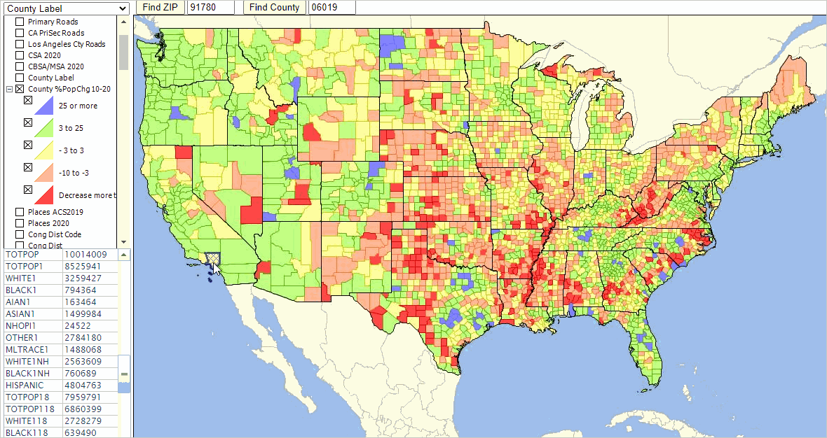

 .
.