|
|
Open VDA Web GIS
no login required; requires only Web browser
this web page: https://proximityone.com/openvda.htm
The Open VDA Web GIS is an alternative version of VDA Web GIS that does not require login.
Click here to start Open VDA Web GIS.
Open VDA Web GIS (OpenVDA) opens the "Base" project. Only the Base project is available to OpenVDA users.
Map/analyze geography shown in these layers. See more about VDA GIS. See terms of use.
Optionally, providing more capability and speed, use the no fee Windows-based VDA Desktop GIS.
Login to get your User ID (one-time).
Then click here to install VDAD.
With VDA Desktop GIS (VDAD) running use File>Open Server Project and select the Base project.
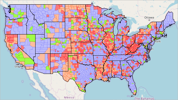
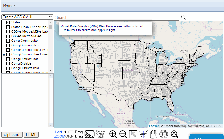
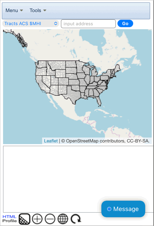
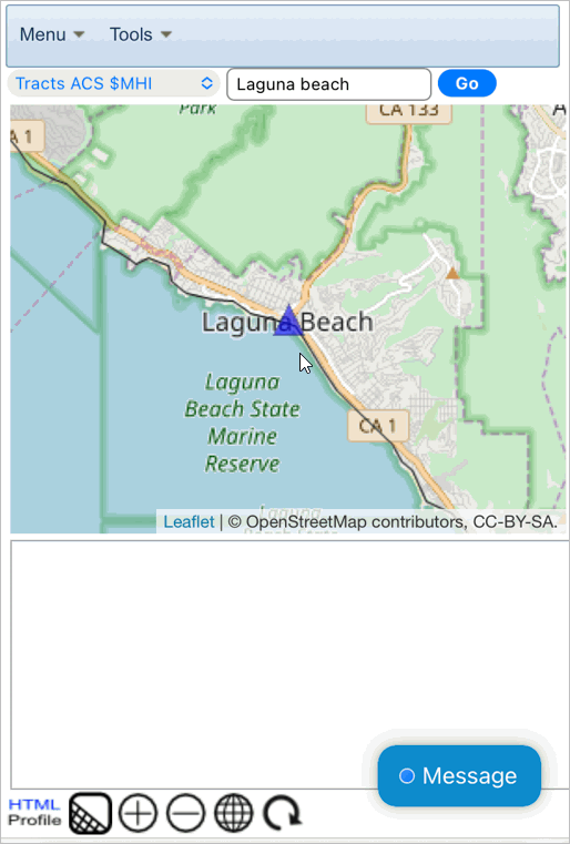
Start-up View
The start-up view shows a geographic extent encompassing the United States contiguous states.
.. county boundaries are shown with light gray outline.
.. the "Counties2" is checked-on in the legend panel at left (scroll down).
.. the "active layer" (upper left drop-down) is set to the "Tracts ACS 2022 $MHI" layer.
- clicking anywhere in map highlights that tract; shows profile in lower left panel.
- see these tracts/data in this interactive table.
.. enter a location, address in searchbar and press enter; map shows zoom-in view and locations marker.
Updates
VDA Framework
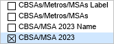
05.15.24 "Base" project updated. See about available layers.
04.08.24 Illustrative App 11 .. Examining Metropolitan Statistical Areas
04.05.24 For extended Metro-related appplications use MetroDynamics Project.
03.30.24 Illustrative App 10 .. Examining Educational Attainment by State Legislative District
03.29.24 VDAGIS Base Project updated with these layers/files
.. vintage 2023 CBSAs with population & components of change annual data & trends
.. state legislative districts (upper and lower) with ACS 2022 Itemset1 data
03.25.24 Vintage 2023 County Population Estimates added to Base Project
.. examine county population & components of change annual data & trends
03.10.24 2023 Vintage CBSAs/Metros now included
02.20.24 Open VDA Web GIS -- Congressional Districts now available
02.02.24 VDAGIS_BASE project updated .. Congressional Districts updated with these new attributes
01.24.24 Illustrative App 09 .. Examining School District Characteristics
12.13.23 OVDAW "Base" and other projects now available via Remote Desktop Service.
11.20.23 Illustrative App 08 .. Examining State Legislative Districts
11.13.23 Illustrative App 07 .. Examining State Quarterly Personal income
10.14.23 Illustrative App 06 .. Using Table/Grid to Locate/MapView Selected Cities
10.10.23 Congressional District Demographic Change Layer added (about)
.. see in gallery
10.10.23 Illustrative App 05 .. Using an iPhone -- 2 steps to find/view a census tract based on an address
10.09.23 Illustrative App 04 .. Using an iPhone to locate/View a Congressional Community based on an address
10.06.23 Illustrative App 03 .. Low & Moderate Income by Census Tract using FFIEC 2023 Data
10.05.23 Illustrative App 02 .. Mapping Congressional Communities & 118th Congressional Districts
10.04.23 Illustrative App 01 .. Mapping Census Tracts and ZIP Codes
10.04.23 User Levels and VDAD Feature Availability .. see recap of user levels
10.03.23 Adding Layers to the Base Project (using VDAD) .. see example below
10.02.23 Base Project Updated .. see Current Base Project Summary below
09.29.23 Congressional Community Diversity Layers added (about)
compare diversity within & across congressional districts
09.26.23 Congressional District Diversity Layers added (about)
State Legislative Districts (Upper SLD22U & Lower SLD22L) added
09.04.23 Tract Census 2020 DP1 Layers added
.. see in gallery .. see metadata
08.26.23 State GDP Time Series added
.. see in gallery .. see metadata (scroll down for GDP series)
Where do I start? .. getting started
.. Current Base Project Summary
Gallery .. Make Maps Like These ... selected examples
How and Why County Population is Changing
Congressional Communities in context of Congressional District CA 47
Congressional District Percent Population Change 2020-2022
.. select 2020 items and ACS2022 items in this layer/shapefile
.. see related views
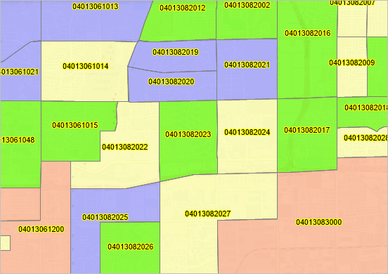
Census Tract %Population Age 65+ in Houston, TX city
Patterns of Economic Prosperity by Census Tract; Phoenix Area
.. with census tract codes
Attributes of a Congressional Community (CC); Phoenix Area
.. click CC then click HTML button lower left to view profile CC profile (xls)
Using Table/Grid Feature; 2020 Urban Areas in Texas Ranked on 2020 Population
.. Urban Areas the active layer; click Table view; use query"select NAME20, ST, POP where st='TX'"; sort descending order on POP
State Quarterly GDP
.. States the active layer; click Table view;
VDA Framework .. goto top
The Visual Data Analytics (VDA) Geographic Information System (GIS) is a multi-dimensional set of software, data and methodoligies
designed to provide mapping, geospatial processing and analysis, data development and maintenance to meet wide-ranging learning, policy analysis
and business intelligence needs.
Learn more about Geographic Information Systems.
VDA Desktop GIS and VDA Web GIS have similar features that can be used separately or together.
Each is a decision-making information resource designed to help stakeholders create and apply insight.
VDA Web GIS is accessed/used with only a Web browser;
nothing to install; GIS experience not required.
VDA Desktop GIS is installed on a Windows computer
and provides a broader range of capabilities compared to VDA Web GIS.
We have expanded the scope of VDA tools data development resources as summarized below.
These harmonized tools now meet all user platforms and devices.
VDA GIS resources have been developed and are maintained by Warren Glimpse, ProximityOne (Alexandria, VA)
and Takashi Hamilton, Tsukasa Consulting (Osaka, Japan).
1. Open VDA GIS Web (OVDAW)
Start OVDAW
About OVDAW
.. similar to VDAW
- fewer features than VDAW
- provides only access to “Base” (comprehensive, frequently updated)
.. no login, no fee, nothing to install
.. see OVDAW step by step application examples
2. VDA Desktop GIS
.. the most powerful, capable tool
.. operates on Windows PC platform
.. for all users but specifically for those processing confidential data on a specific computer
.. more information
3. CV XE GIS
.. similar to VDA Desktop GIS
.. operates on Windows PC platform
.. for all users but specifically for those processing confidential data on a specific computer
.. more information
4. VDA Desktop GIS via RDS
.. the most powerful, capable tool
.. run online via Remote Desktop Service
.. operates using most platforms and devices (including Mac, iOS)
.. very fast even with Internet interface
.. enables access to existing VDAW web-based
.. more information
5. Demographic-Economic Data Explorer (DEDE
.. create custom GIS friendly data files
.. choose from multi-sourced Federal Statistical System
.. use your data with GIS tools, your own software, Excel, or other tools
6. Custom solutions
Getting Started -- VDA GIS Base Project using OVDAW
.. start-up view:
After installation and with start-up view above, there are many paths to take. Usage steps will vary depending on your objectives.
There are two illustrative applications below. More generally, usage might start by thinking about an application objective.
This might be like:
.. thematic map view of %pop 65+ by census tract in the Orange County, CA area
with Congressional Communities labeled.
The steps might be (from start-up view):
.. key in "laguna beach" (no quotes) in search bar.
.. change active layer from "Tracts $MHI" to "Tracts DP1 %Age65+" (no quotes)
.. below map, click [-] twice (zoom out)
.. in legend panel click these checkboxes on:
- Cong Comm Label
- Cong Communities
- Cong Comm Label
- Cong District Label
- Cong Districts Bold
- Tracts DP1 %Age65+
.. zoom to adjust to obtain this view:
.. to view demographic profile for tract at pointer in graphic ...
- click tract at pointer; profile shows in lower left panel
- clicl HTML button below profile to open HTML profile view (new tab)
Orientation .. at start-up ..
The start-up view shows the U.S. contiguous states.
Counties and States layers are checked-on in the legend panel at left.
.. this enables those layers to be shown in the map window.
Find (navigate to) an address or area of interest ..
.. enter a ZIP code, address or location in search bar and press .
How OVDAW operation/features differ from VDAW and VDAD.
.. only the Base GIS project is available using OVDAW.
.. extended features on the top menu bar are not available using VDAW and VDAD.
.. custom structured profiles are not available with OVDAW (available using VDAW and VDAD)
.. layers cannot be edited using OVDAW (use VDAW or VDAD)
Menu .. top banner
Click "Menu" in the top banner to access the Menu dropdown shown below.

Selecting and Using the Active Layer
The "Active Layer" (layers are shown in the Legend Panel) is set by selecting a layer from the upper left dropdown.
.. the default setting is census tracts -- "Tracts $MHI"
.. the tracts layer is the default Active Layer to facilitate easily locating a census tract based on an address.
Role of the Active Layer
When you click on a shape/object in the map, a profile is shown in lower left, for the Active Layer object.
.. to view attributes and shape highlight for a Congressional Community (CC), you would:
1) make Congressional Communities as the Active Layer, 2) click in the map to highlight/select a CC.
.. the selected Active Layer stays on/selected until it is changed or VDA Web Base/browser is closed/session ended.
Illustrative applications
Two steps to locate/map/view a census tract based on address
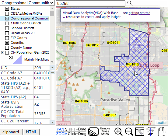
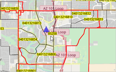
.. enter address, maybe only enter ZIP 85258 to illustrate (in Scottsdale, AZ)
.. at refreshed zoom view, click blue marker on map
.. tract boundary appears; see tract code & demographics in profile below map
.. the tract code is 04013216807
Where is my Congressional Community and what are its attributes?
Locate/map/view a Congressional Community (CC) based on address
.. make active layer Congressional Communities (select from upper left dropdown)
.. enter address, maybe only enter 85258 to illustrate (ZIP code in Scottsdale, AZ)
.. at refreshed zoom view, click blue marker on map
.. CC boundary appears; see CC code & demographics in profile below map
.. the CC code 0401010 .. CD118 AZ 01 010
Recap of VDA User Levels .. goto top
OVDAW users .. User Level does not apply.
Level 0 - install VDAD without VDAW signup and without VDAD File>Login
Enables:
VDAD File>Login (sets features available; selection of other Level)
VDAD Open GIS project.
VDAD Search for location/address
VDAD Find shape
VDAD Selected object profile
VDAD use of legend and layer editor.
VDAD map navigation features
VDAD opening of and VDAGIS local project
VDAD settings
Level 1 - VDAW signup defaulting to Level 1, then with VDAD Level 1 with File>Login
Enables Level 0 plus:
VDAD adding layers to Base Server Project
VDAD opening Base Server Project
VDAD access to Database features
Level 2 - VDAW signup with Level 2 then with VDAD Level 2 with File>Login
Enables Level 1 plus:
VDAD open many server projects available
VDAD using Table/Grid
VDAD adding layers to Base Server Project
VDAD saving project
Level 3 - VDAW signup with Level 3 then with VDAD Level 3 with File>Login
Enables Level 2 plus:
VDAD Analytics>GeoSelect/SiteAnalysis
VDAD batch geocoding
VDAD Tools features
Base Project Updates 03/10/24: new 2023 Vintage CBSA Layers Added .. goto top
2023 Vintage CBSA (Core-based Statistical Areas) layers have been added to the project.
The 2023 vintage is an updated delineation showing CBSA (MSAs/MISAs) as defined by OMB as of July 2023.
To view 2023 vintage MSAs, check-on the CBSA 2023 layer as shown in the graphic.
End of this Base Project Updates section.
Base Project Updates 02/02/24: new Congressional District layer attributes .. goto top
.. added subject matter fields
B01001_001E TotPopA22  Total Population
B01001_002E MPopA22    Male
B01001_026E FPopA22    Female
B02001_002E White1A22  White alone
B02001_003E Black1A22  Black or African American alone
B02001_004E AIAN1A22   American Indian and Alaska Native alone
B02001_005E Asian1A22  Asian alone
B02001_006E NHOPI1A22  Native Hawaiian and Other Pacific Islander alone
B02001_007E Other1A22  Some other race alone
B02001_008E MultiA22   Two or more races
B03002_012E HispA22    Hispanic (any race)
B01001_003E A0004MA22  Male: Under 5 years
B01001_004E A0509MA22  Male: 5 to 9 years
B01001_005E A1014MA22  Male: 10 to 14 years
B01001_006E A1517MA22  Male: 15 to 17 years
B01001_027E A0004FA22  Female: Under 5 years
B01001_028E A0509FA22  Female: 5 to 9 years
B01001_029E A1014FA22  Female: 10 to 14 years
B01001_030E A1517FA22  Female: 15 to 17 years
B09020_001E Pop65upA22 Population 65 years and over
B11002_001E PopHHA22   Population in Households
B11001_001E HHA22      Total Households
B11001_002E FamA22     Family Households
B15002_001E Pop25upA22 Population 25 years and over
B15002_011E EAHSMA22   Male: High school graduate (includes equivalency)
B15002_015E EABMA22    Male: Bachelor's degree
B15002_016E EAMMA22    Male: Master's degree
B15002_017E EAPMA22    Male: Professional school degree
B15002_018E EADMA22    Male: Doctorate degree
B15002_028E EAHSFA22   Female: High school graduate (includes equivalency)
B15002_032E EABFA22    Female: Bachelor's degree
B15002_033E EAMFA22    Female: Master's degree
B15002_034E EAPFA22    Female: Professional school degree
B15002_035E EADFA22    Female: Doctorate degree
B29001_001E VATOTA22   Total Citizen, Voting-Age Population
B29001_002E VA1829A22  Total Citizen, Voting-Age Population 18 to 29 years
B29001_003E VA3044A22  Total Citizen, Voting-Age Population 30 to 44 years
B29001_004E VA4564A22  Total Citizen, Voting-Age Population 45 to 64 years
B29001_005E VA65UPA22  Total Citizen, Voting-Age Population 65 or more years
B25003_001E TotHsgA22  Total housing units
B25003_002E OwnOccA22  Owner occupied units
B25003_003E RntOccA22  Renter occupied units
B25002_003E VacantA22  Vacant units
B25105_001E MDMTHHCA22 Median Monthly Housing Costs (Dollars)
B19013_001E MHIA22     Median Household Income
B19113_001E MFIA22     Median Family Income
B25077_001E MHVA22     Median housing value
B25064_001E MdRentA22  Median gross rent
B19083_001E GiniA22    Gini Index of Income Inequality
End of this Base Project Updates section.
Open VDA Web GIS -- Congressional Districts .. goto top
Click to Start OVDAW CD
How OVDAW CD differs/is similar to OVDAW:
OVDAW CD and OVDAW have the same general features.
OVDAW CD and OVDAW use the same "Base" project; layers are the same.
OVDAW CD opening view shows Congressional Districts; OVDAW opening view shows counties.
OVDAW CD start active layer is Congressional Districts; OVDAW start active layer is census tracts.
With OVDAW CD, click in map to see CD highlight & show profile.
With OVDAW, click in map to see tract highlight & show profile.
The user can change either to mimic the other.
End of this OVDAW CD section.
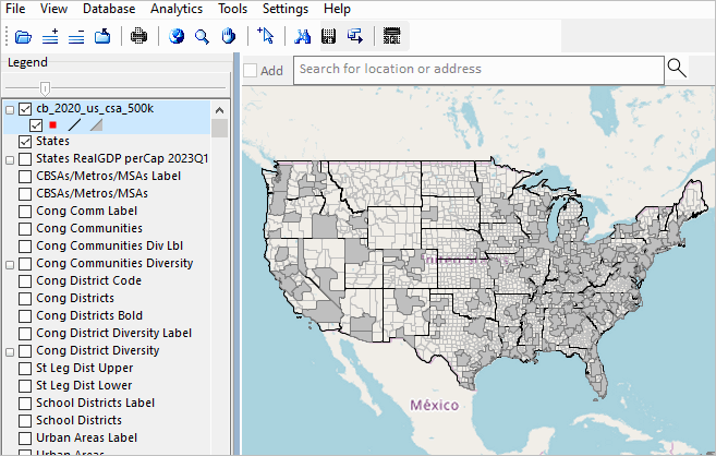
Adding Layers to the Base Project .. goto top
By design, layers cannot be added to the Base Project using OVDAW. The following notes illustrate how the
Combined Statistical Areas shapefile can be added to the Base project, as a server project, using VDAD.
Other examples .. neigborhood shapefile .. client/member data .. census blocks for a county/area .. intersection to intersection streets shapefile ..
results of a survey/poll as point or summary data, etc.
Combined Statistical Areas (CSAs) are geographic areas formed when two or more CBSAs have a shared boundary. A procedure is applied by the
Census Bureau/OMB to determine which "sets" of CBSAs form CSAs.
1. click here
to download the 2020 vintage CSA shapefile to a folder. Expand that zip file to (for example) d:\temp. The shapefile
d:\temp\cb_2020_us_csa_500k.shp now exists.
2. With VDAD running on your Windows computer
VDA Desktop GIS (VDAD) .. install and auto start
Level 1 or higher; File>Login with VDAD running
3. Use VDAD File>Open Server Project to open the Base project.
4. Click [+] Add Layer on toolbar and open d:\temp\cb_2020_us_csa_500k.shp
VDAD nows shows the CSA layer as illustrated in the following graphic:
App 01 -- Mapping Tracts & ZIP Codes .. goto top
Consider an application where you want to view a few census tracts in context of ZIP Code areas.
Steps below illustrate use of the Open VDA Web GIS (OVDAW)
Start OVDAW .. desktop recommended.
After the map view shows, enter a ZIP code, location or address in the Search bar and press enter.
.. to illustrate, enter 85258 (a ZIP code in Scottsdale, AZ) and press enter
A zoom-in then shows a blue triangle marker at the location.
.. in the legend panel at left, click checkbox on for each of these layers:
- ZIP Codes Label (displays ZIP Code area labels/codes in map)
- ZIP Codes (displays ZIP Code area red boundaries in map)
- Tracts Label (displays Tract code and black tract boundaries in map)
.. navigate to preferred view (e.g., pan or zoom in/out)
.. use a screen capture tool to capture view meeting application objective
Pointer in graphic shows ZIP code 85258 with several tracts intersecting the 85258 ZIP code red boundary.
End of App 01.
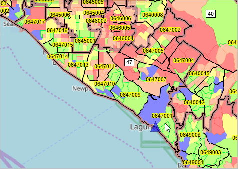
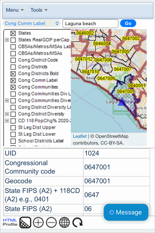
App 02 -- Mapping Congressional Communities & 118th Congressional Districts .. goto top
Consider an application where you want to view a
congressional community
in context of the corresponding congressional district. See more about congressional communities
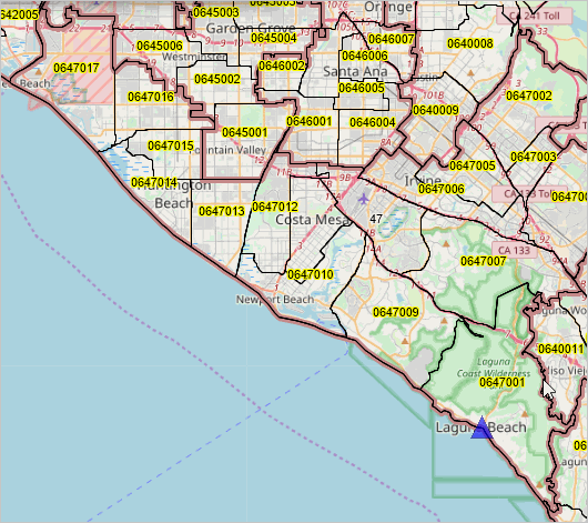
The objective of App 02 is to learn about congressional communities (CCs) in context of the Laguna Beach, CA area.
Steps below illustrate use of the Open VDA Web GIS (OVDAW) to meet this objective
1. Click here to start OVDAW .. desktop recommended.
2. After the map view shows, enter a ZIP code, location or address in the Search bar and press enter.
.. to illustrate, enter "Laguna Beach" (no quotes, in Orange County, CA) and press enter.
3. A zoom-in then shows a blue triangle marker at the location.
.. in the legend panel at left, click checkbox on for each of these layers:
- Cong District Code (displays Congressional District code in map)
- Cong District Bold (displays Congressional Districts with bold boundary in map)
- Cong Comm Label (displays Congressional Community labels/codes in map)
- Cong Communities (displays Congressional Communities with black CC boundaries in map)
.. navigate to preferred view (e.g., pan or zoom in/out)
.. use a screen capture tool to capture view meeting application objective
3. Make the "Cong Communities" layer the active layer by selecting "Cong Communities" from top left dropdown.
4. Click the blue marker and CC 0647001 highlights; a demographic profile shows in lower left panel.
.. see other CCs comprising this CD.
.. CCs are shown with a 7-character numeric code.
.. CC 0647001 is located in California (06), congressional district 47 (47) and is uniquely coded 001 in that CD.
.. see more about CCs
6. Examine CCs using the interactive table.
.. this is a separate operation not provided by OVDAW.
.. to examine CCs located in CD CA 47,
- 1) click the ShowAll button below the table.
- 2) click Find CD button below table; the table refreshes showing all CCs in this CD.
.. a similar operation can be performed using OVDAW.
End of App 02.
App 03 -- Low & Moderate Income by Census Tract using FFIEC 2023 Data .. goto top
Consider an application where you want to examine low & moderate income patterns by census tract.
(table on that page not yet updated with these data released Sep 2023)
Steps below illustrate use of the Open VDA Web GIS (OVDAW)
Start OVDAW .. desktop recommended.
After the map view shows, enter a ZIP code, location or address in the Search bar and press enter.
.. to illustrate, enter "Laguna Beach" (no quotes, in Orange County, CA) and press enter
A zoom-in then shows a blue triangle marker at the location.
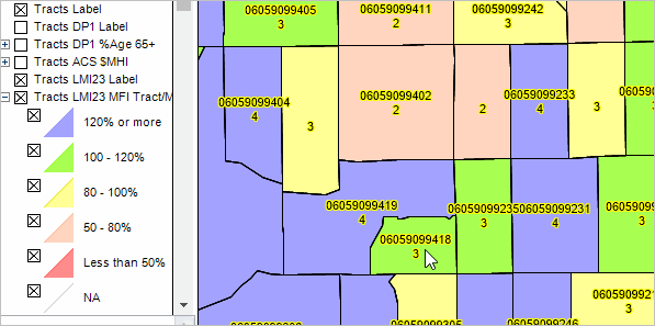
.. in the legend panel at left, click checkbox on for each of these layers (scroll down in legend at left):
- Tracts Label (displays 11 character tracts code in map)
- Tracts LMI23 Label (displays Tract LMIIndex 1 low, 2 moderate, 3 middle or 4 high in map)
- Tracts LMI23 MFI Tract/MSA% (displays tract median family income as % of MSA MFI thematic pattern map)
.. navigate to preferred view (e.g., pan or zoom in/out)
.. use a screen capture tool to capture view meeting application objective
FFIEC Details about these data (XLS)
End of App 03.
App 04 -- Using an iPhone .. goto top
Consider an application where you want
use an iPhone
to view a congressional community in context of the corresponding congressional district.
Steps below illustrate use of the Open VDA Web GIS (OVDAW)
.. ideally view this page in a different device (desktop maybe) and follow steps below operationally on phone.
.. note that phone user interface differs slightly from VDAGIS desktop/other platforms.
Using an iPhone with Safari .. Start OVDAW
The start-up screen appears:
After the map view shows, enter a ZIP code, location or address in the Search bar and press enter.
.. to illustrate, enter "Laguna Beach" (no quotes, in Orange County, CA) and press enter
Next, the zoom-in view:
After zoom view above, click Menu>Tools>Legend Panel(on/off) -- select on
.. in the legend panel at left, click checkbox on for each of these layers:
- Cong District Code (displays Congressional District code in map)
- Cong District Bold (displays Congressional Districts with bold boundary in map)
- Cong Comm Label (displays Congressional Community labels/codes in map)
- Cong Communities (displays Congressional Communities with black CC boundaries in map)
In the top left drop-down above the legend, select the "Cong Comm Label" (see in graphic below.
.. navigate to preferred view (e.g., pan or zoom in/out)
.. use a screen capture tool to capture view meeting application objective
Click the blue marker and a profile for Congressional Community 0647001 displays below the map.
.. CC 0647001 displays as selected (cross-hatched)
.. click any CC to select that CC and show profile
The next view shows the cumulative result:
Scroll down the tabular display to view more demographic characteristics.
Optionally click the HTML button (lower left) to view the tabular data in HTML format.
Optionally ctrl-C then ctrl-A on the HTML profile page and copy/paste the data into a blank Excel sheet.
Another area? Enter any address in search bar and follow similar steps above to view those CCs.
End of App 04.
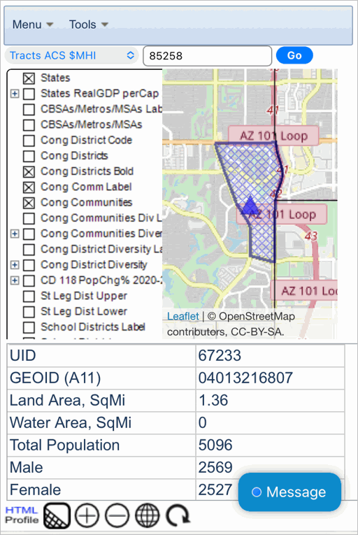
App 05 -- Using an iPhone .. 2 steps to get tract code for address .. goto top
Consider an application where you want
use an iPhone
to find/view a
census tract based on an address.
Steps below illustrate use of the Open VDA Web GIS (OVDAW)
.. ideally view this page in a different device (desktop maybe) and follow steps below operationally on phone.
.. note that phone user interface differs slightly from VDAGIS desktop/other platforms.
Using an iPhone with Safari .. Start OVDAW
The start-up screen appears:
Step 1. After the map view shows, enter ZIP code 85258 (Scottsdale, AZ) optionally enter an address in the Search bar and press enter.
.. the zoom-in view appears
Step 2. click the blue marker
.. the tract containing the ZIP code/address appears.
.. the demographic profile for the tract shows below the map.
.. see value of GEOID (census tract code) is 04013216807.
Optionally click the HTML button (lower left) to view the tabular data in HTML format.
Optionally ctrl-C then ctrl-A on the HTML profile page and copy/paste the data into a blank Excel sheet.
Another area? Enter any address in search bar and follow similar steps above to view the tract.
End of App 05.
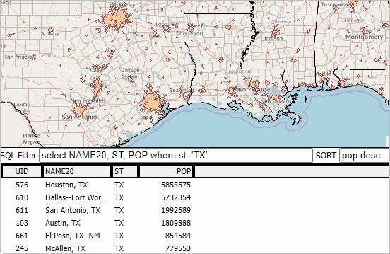
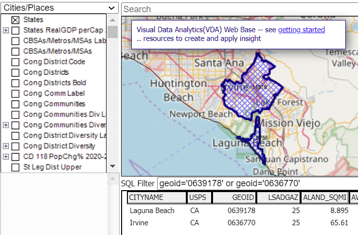
App 06 -- Using Table/Grid to Locate/TableMapView Selected Cities .. goto top
Consider an application where you want
to find selected cities/places
and show them in the Table/Grid and highlight in Map Window.
Steps below illustrate use of the Open VDA Web GIS (OVDAW)
Start OVDAW .. desktop recommended.
.. ideally view this mini section page in one one window and follow steps below operationally in a different window.
This example shows how to select and compare Laguna Beach, CA (place code 0639178) with Irvine, CA (place code 0636770).
This operation could be one or more cities/places anywhere in the U.S.
In this example, place codes, geocodes, are used in a query.
City/place codes are found in
this table
or users might have the codes(s) otherwise.
Step 1. After the map view shows, select the Cities layer in the top left dropdown.
Step 2. On the toolbar, click the rightmost SQL button.
The table then shows in a grid displayed below the map window.
Each row corresponds to a city/place in the Cities layer dataset.
Step 3. Enter filter/query in the "SQL Filter" edit box at the top left of the Table form.
.. enter "geoid='0639178' or geoid='0636770'" (no double quotes) in the SQL Filter edit box.
.. then click query button; view refreshes showing just the two cities rows in table.
.. click rightmost button below table "Highlight all that meet query"
.. map refreshes with view similar graphic shown below; navigate to this specific map view.
Laguna Beach, CA (place code 0639178) with Irvine, CA (place code 0636770)
Optionally click the HTML button (lower left) to view the tabular data in HTML format.
Optionally ctrl-C then ctrl-A on the HTML profile page and copy/paste the data into a blank Excel sheet.
Other areas? Enter different SQL Filter and click Query button.
End of App 06.
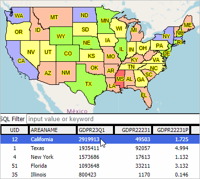
App 07 -- Examining State Quarterly Personal income .. goto top
Consider an application where you want
to examine characteristics and patterns in state quarterly personal income.
See more about these data and personal income.
Open VDA Web GIS (OVDAW)
provides the capabilities
of examining these data in context of other subject matter and geography.
Steps below illustrate use of the Open VDA Web GIS (OVDAW)
Start OVDAW .. desktop recommended.
.. ideally view this mini section page in one one window and follow steps below operationally in a different window.
Step 1. After the map view shows, click-on the two State PCPI layers as shown in the graphic below
Step 2. Getting the Grid view. On the toolbar, click the rightmost SQL button.
The table then shows in a grid displayed below the map window.
Each row corresponds to a state.
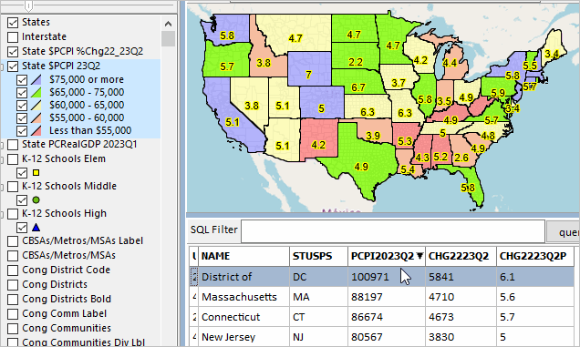
Patterns of State Quarterly Per Capita Personal Income
.. see legend at left showing colors and intervals corresponding to 2023Q2 state per capita personal income.
.. states are labeled with percent change in state PCPI 2022Q2 to 2023Q3.
Optionally click the HTML button (lower left) to view the tabular data in HTML format.
Optionally ctrl-C then ctrl-A on the HTML profile page and copy/paste the data into a blank Excel sheet.
Other areas? Enter different SQL Filter and click Query button.
End of App 07.
App 08 -- Examining State Legislative Districts .. goto top
Consider an application where you want
to examine characteristics and patterns state legislative districts.
See more about State Legilative Districts, 2022 Cycle.
Open VDA Web GIS (OVDAW)
provides the capabilities
of examining these data in context of other subject matter and geography.
Steps below illustrate use of the Open VDA Web GIS (OVDAW)
Start OVDAW .. desktop recommended.
.. ideally view this mini section page in one one window and follow steps below operationally in a different window.
Step 1. After the map view shows, click-on the two State PCPI layers as shown in the graphic below
Step 2. Getting the Grid view. On the toolbar, click the rightmost SQL button.
The table then shows in a grid displayed below the map window.
Each row corresponds to a state.
Patterns of State Quarterly Per Capita Personal Income
.. see legend at left showing colors and intervals corresponding to 2023Q2 state per capita personal income.
.. states are labeled with percent change in state PCPI 2022Q2 to 2023Q3.
Optionally click the HTML button (lower left) to view the tabular data in HTML format.
Optionally ctrl-C then ctrl-A on the HTML profile page and copy/paste the data into a blank Excel sheet.
Other areas? Enter different SQL Filter and click Query button.
End of App 08.
App 09 -- Examining School District Characteristics .. goto top
Consider an application where you want
to examine characteristics and patterns of a school district.
See the School District Interactive Table
for a list of school districts.
Open VDA Web GIS (OVDAW)
provides the capabilities
of examining these data in context of other subject matter and geography.
Steps below illustrate use of the Open VDA Web GIS (OVDAW)
Click here to start OVDAW .. desktop recommended.
.. ideally view this mini section page in one window and follow steps below operationally in a different window.
Step 1. After the map view shows, use the upper left drop-down to set/select "School Districts" as the "active layer"
Step 2. Locate the school district of interest. In the Searchbar above the map window, key in the address or location name.
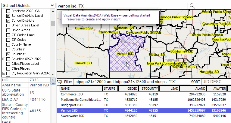
Use "Vernon ISD, TX" (no quotes) in this example.
Then press enter. The map view zooms to that location and shows a blue marker.
Step 3. View/examine the district demographic profile
.. click the blue marker.
.. the school district shows with a blue crosshatch pattern. Navigate, zoom out to view the entire district.
.. optionally click on the checkbox for the School District Label and School Districts layers
in the Legend Panel to view district boundaries and names.
.. a demographic profile for the school district shows in the lower left panel.
.. optionally click the HTML button (lower left) to view the tabular data in HTML format.
in the HTML page, see that Vernon ISD, TX has an ACS 2021 total population of 12,281.
scrolling to the bottom of the HTML page, see the total area is 1464583501 square meters.
or 1464583501/2589988 = 565.5 square miles
.. optionally ctrl-C then ctrl-A on the HTML profile page and copy/paste the data into a blank Excel sheet.
Step 4. Examining this district in context of others -- getting the Grid view.
.. on the toolbar at bottom, click the rightmost SQL button.
.. the table then shows in a grid displayed below the map window.
.. each row corresponds to a school district.
Paste this filter into the SQL Filter edit box:
totpopa21>12000 and totpopa21<12500 and stusps='TX'
then click the Query button to view that Vernon ISD has a peer group of five Texas school districts with population 12,000 to 12,500.
End of App 09.
App 10 -- Examining Educational Attainment by State Legislative District .. goto top
Consider an application where you want
to examine characteristics and patterns of state legislative districts in a state (or all states).
Open VDA Web GIS (OVDAW)
provides the capabilities
of examining these data in context of other subject matter and geography.
Steps below illustrate use of the Open VDA Web GIS (OVDAW)
Click here to start OVDAW .. desktop recommended.
.. ideally view this mini section page in one window and follow steps below operationally in a different window.
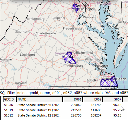
Follow the steps below to make a view as shown in the following graphic.
This view shows a map of Virginia with the upper chamber state legislative districts (SLDs) having a percent high school educational attainment (S067) of more that 95 percent.
There are 3 Senate SLDs that meet this criteria. These Senate SLDs are shown in the table below the map. The table also includes median household income, many other attributes
can be selected
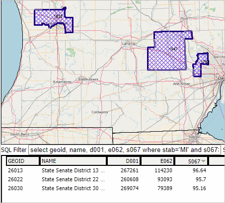
Simply change the state in the query to examine any state. This graphic shows Michigan:
Step 1. After the map view shows, use the upper left drop-down to set/select "St Leg Dist Upper Code" as the "active layer"
Step 2. Click the "A" button below the map view and at right to view the data table for all U.S. SLDs.
Step 3. Copy the following SQL Filter and paste it into the SQL Filter edit box:
select geoid, name, d001, e062, s067 where stab='VA' and s067>95
Step 4. Copy the following Sort setting and paste it into the SORT edit box:
s067 desc
Step 5. Click the Query button. The view shows the table populated with districts that meet the query.
Step 6. Click the "Highlight all that meet query button" below the table at right.
The map view now shows these SLDs crosshatched. Navigate, zoom-out to view all districts meeting criteria.
End of App 10.
App 11 -- Examining Metropolitan Statistical Areas .. goto top
Consider an application where you want
to examine characteristics and patterns of a metropolitan statistical area (or all metros).
Open VDA Web GIS (OVDAW)
provides the capabilities
of examining these data in context of other subject matter and geography.
Steps below illustrate use of the Open VDA Web GIS (OpenVDA)
Click here to start OpenVDA .. desktop recommended.
.. ideally view this mini section page in one window and follow steps below operationally in a different window.
Follow the steps below to make a view as shown in the following graphic.
This view shows a map of the contiguous 48 states with the largest 10 metropolitan statistical areas highlighted in the map.
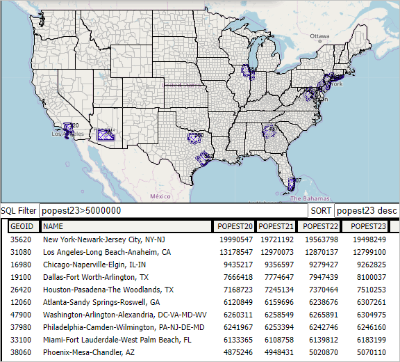
Step 1. After the map view shows, use the upper left drop-down to set/select "CBSA2023" as the "active layer"
.. CBSAs: Core-Based Statistical Areas; MSAs: Metropolitan Statistical Areas: MSAs
Step 2. Click the "A" button below the map view and at right to view the data table for all CBSAs.
Step 3. Copy the following SQL Filter and paste it into the SQL Filter edit box:
popest23>5000000
(this says to select any metro with a 2023 population greater than 5 million)
Step 4. Copy the following Sort setting and paste it into the SORT edit box:
popest23 desc
Step 5. Click the Query button. The view shows the table populated with metros that meet the query.
Step 6. Click the "Highlight all that meet query button" below the table at right.
The map view now shows these metros crosshatched. Navigate, zoom-out to view all metros meeting the criteria.
End of App 11.
Current Base Project Summary .. goto top
Usage notes
The "Base project" is a VDAGIS "GIS Project". A GIS project is text file that references several layers.
Layers are typically shapefiles but for VDA Web operations converted to SQLite format.
Access
The Base project may be accessed by:
1. anyone using Open VDA Web GIS
-- start -- no login, no fee, only browser needed, nothing to install
2. VDA Web GIS (VDAW) users
-- start -- extended features, no fee option, other projects, signup required, nothing to install
3. VDA Desktop GIS (VDAD) users
– register -- install and auto start -- File>Open Server Project -- Windows based, requires installation, no fee option
For Windows users, VDAD is always recommended. It can open the Base project as server project.
.. the layers may be repositioned in the legend panel by click-hold-slide.
.. layer attributes are easily modified.
.. shapefiles from other sources are easily added.
Content (Layers)
This update adds these layers:
.. Interstate/primary roads
.. State $PCPI %Change 2022Q2-2023Q2 as label
.. State $PCPI 2023Q2 thematic pattern
.. K-12 schools by school level; one shapefile, three queries.
.. updated/extended school district layer
Previous update .. all 160 Census 2020 Demographic Profile 1 (DP1) items are included in these layers (same shapefile)
- Cong Communities Div Lbl
- Cong Communities Diversity
Among other things, this enables viewing, sorting, querying these demographic data in table mode.
.. and interactively using table lookups to view corresponding CC shapes in the map view.
Layer list:
| Caption | Description |
| States | States |
| Interstate/primary roads | |
| State $PCPI %Change 2022Q2-2023Q2 as label | |
| State $PCPI 2023Q2 thematic pattern | |
| States RealGDP perCap 2023Q1 | States GDP |
| K-12 Schools, Elementary | |
| K-12 Schools, Middle | |
| K-12 Schools, High | |
| CBSAs/Metros/MSAs Label | CBSAs/Metros/MSAs Label
- all 2020 CBSAs but query applied to show only MSAs |
| CBSAs/Metros/MSAs | CBSAs/Metros/MSAs
- all 2020 CBSAs but query applied to show only MSAs |
| |
| Cong District Code | Congressional Districts Code |
| Cong Districts | Congressional Districts Boundary |
| Cong Districts Bold | Congressional Districts Bold Boundary |
| |
| Cong Comm Label | Congressional Communities CC/CD Compare Code |
| Cong Communities | Congressional Communities CC/CD Compare Boundary | |
| Cong Communities Div Lbl | Congressional Communities DP1 Diversity Label (all DP1 items) |
| Cong Communities Diversity | Congressional Communities DP1 Diversity Thematic Pattern (all DP1 items) |
| |
| Cong District Diversity Label | Congressional Districts DP1 Diversity Label (DP1 items) |
| Cong District Diversity | Congressional Districts DP1 Diversity Thematic Pattern (DP1 items) |
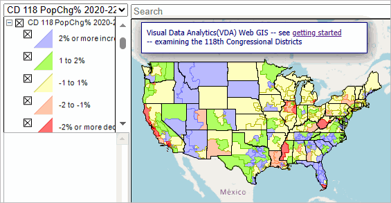
| CD 118 PopChg% 2020-22 | Congressional Districts PopChg% 2020-22 Thematic Pattern (Cen 2020 & ACS 2022 items) |
| |
| St Leg Dist Upper | State Legislative Districts Upper Chamber/Senate |
| St Leg Dist Lower | State Legislative Districts Lower Chamber/House |
| |
| School Districts Label | School Districts Code |
| School Districts | School District extended attributes |
| |
| Urban Areas Label | Urban Areas Code |
| Urban Areas | Urban Areas fill pattern |
| |
| ZIP Codes Label | ZIP Code (ZCTAs) Code |
| ZIP Codes | ZIP Code (ZCTAs) Boundary+ |
| |
| County Name | County Name |
| Counties1 | County Boundary 1 |
| Counties2 | County Boundary 2 |
| |
| Cities/Places Label | Cities/Places Label (Pop 2022) |
| Cities/Places | Cities/Places Boundary (Pop 2022) |
| |
| Cty Population Gain 2020-22 | County Population Change Gain |
| Cty Population Loss 2020-22 | County Population Change Loss |
| |
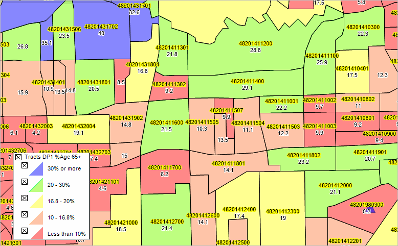
| Tracts Label | Census Tracts Code |
| Tracts DP1 Label | Census Tracts DP1 %Age 65+ Label (all DP1 items) |
| Tracts DP1 %Age 65+ | Census Tracts DP1 %Age 65+ Thematic Pattern (all DP1 items) |
| Tracts ACS $MHI | Census Tracts ACS $MHI Thematic Pattern |
| Tracts LMI23 Label | Census Tracts Low & Moderate Income; LMI Index |
| Tracts LMI23 MFI Tract/MSA% | Census Tracts Low & Moderate Income
Tract Median Family Income as %MSA Median Family Income Thematic Pattern |
| |
| BaseLayer | Open Streets Map Topology |
| States1 | States Base |
Base Project Layers .. these fieldname lists may not be up-to-date ..goto top
The Base Project includes layers listed below.
.. a project (GIS project) is a set of layers with with settings that show determine how that layer is shown in Map Window.
settings .. such as area/marker attributes including outline, label/label depiction, query if any.
.. a layer is a reference to a shapefile, SQLite, or other file that can be shown in the Map Window.
.. layer names are shown in the Legend Panel at left of Map Window.
.. most layers in this project are shown twice, once to accomodate label only.
this is a convenience to "click-on" a layer to show label only.
the same underlying shapefile/SQLite file is used.
| Layer name | Description & Use |
| States |
metadata |
| State Real GDP Time Series |
metadata |
| |
| CBSAs/Metros/MSAs Label |
metadata ..
about .. click checkbox on to show Metro name as label |
| CBSAs/Metros/MSAs |
about .. MSAs .. metropolitan statisitcal areas |
| |
| Congressional Communities |
about .. Congressional Community (CC) code |
| Congressional Communities |
about .. Congressional Community (CC) with no code |
| |
| Congressional Districts Label |
about .. click checkbox to on to show CD as label |
| Congressional Districts |
about |
| Congressional Districts Bold |
about .. a bolded boundary for zoom in use |
| |
| School Districts Label |
about .. click checkbox on to show district name as label |
| School Districts |
about |
| |
| Urban Areas Label |
about .. click checkbox on to show UA name as label |
| Urban Areas |
about |
| |
| ZIP Codes Label |
about .. click checkbox on to show ZIP Code as label |
| ZIP Codes | |
| |
| County Name |
about .. click checkbox on to show county name as label |
| Counties1 |
about .. bolder boundary |
| Counties2 |
about .. checked on as default .. light boundary |
| |
| Cities/Places Label |
about .. click checkbox on to show city name as label |
| Cities/Places |
about |
| |
| Cty Population Gain 2020-22 |
How & Why County Population is Changing -- gaining population |
| Cty Population Loss 2020-22 |
How & Why County Population is Changing -- losing population |
| |
| Tracts Code |
about .. click checkbox on to show tract code as label |
| |
| Tracts DP1 Label |
metadata ..
about .. click checkbox on to show Tracts |
| Tracts DP1 Age 65+ |
metadata ..
about .. click checkbox on to show patterns of 2020 Census %population 65 years and over |
| |
about .. click checkbox on to show tract code as label
| Tracts ACS $MHI | patterns of median household income |
| |
| BaseLayer | .. OpenStreetMaps topology |
| States1 | |
States layer metadata .. goto layers
Layer 1 -- LayerName: cb_2020_us_state_so51.SHP4 -- LayerFileName: cb_2020_us_state_so51.shp
States
| fieldname | title |
| AREANAME | Area Name |
| STAB | USPS State abbreviation |
| GEOID | Unique geocode |
| AREALAND | Land area SqMt |
| AREAWATR | Water area SqMt |
| APPPOP20 | Apportionment population, 2020 |
| REPS20 | Representatives, 2020 |
| APPOP10 | Apportionment population, 2010 |
| REPS10 | Representatives, 2021 |
| POP10 | Total population, Census 2010 |
| POP110 | Population, one race, Census 2010 |
| WH10 | White, one race, Census 2010 |
| BL10 | Black, one race, Census 2010 |
| AI10 | American Indian/Alaska Native, one race, Census 2010 |
| AS10 | Asian, one race, Census 2010 |
| NH10 | Native Hawaiian, Other Pacific Islander, one race, Census 2010 |
| OR10 | Other, one race, Census 2010 |
| MR10 | Multirace, Census 2010 |
| HS10 | Hispanic, Census 2010 |
| WHNH10 | White, NonHispanic, one race, Census 2010 |
| BLNH10 | Black, NonHispanic, one race, Census 2010 |
| GQ10 | Group Quarters, Census 2010 |
| GQI10 | Group Quarters, Institutional, Census 2010 |
| GQN10 | Group Quarters, Non-Institutional, Census 2010 |
| HSGUNIT10 | Housing units, Census 2010 |
| OCCUNIT10 | Households, Census 2010 |
| VACUNIT10 | Vacant Units, Census 2010 |
| POP20 | Total population, Census 2020 |
| POP120 | Population, one race, Census 2020 |
| WH20 | White, one race, Census 2020 |
| BL20 | Black, one race, Census 2020 |
| AI20 | American Indian/Alaska Native, one race, Census 2020 |
| AS20 | Asian, one race, Census 2020 |
| NH20 | Native Hawaiian, Other Pacific Islander, one race, Census 2020 |
| OR20 | Other, one race, Census 2020 |
| MR20 | Multirace, Census 2020 |
| HS20 | Hispanic, Census 2020 |
| WHNH20 | White, NonHispanic, one race, Census 2020 |
| BLNH20 | Black, NonHispanic, one race, Census 2020 |
| GQ20 | Group Quarters, Census 2020 |
| GQI20 | Group Quarters, Institutional, Census 2020 |
| GQN20 | Group Quarters, Non-Institutional, Census 2020 |
| HSGUNIT20 | Housing units, Census 2020 |
| OCCUNIT20 | Households, Census 2020 |
| VACUNIT20 | Vacant Units, Census 2020 |
| MHIA20 | Median Household Income, ACS20 |
| MFIA20 | Median Family Income, ACS20 |
| MHVA20 | Median Housing Value, ACS20 |
| MDRENTA20 | Median Rent, ACS20 |
| GINIA20 | GINI Index, ACS20 |
| PCE_PC10 | Personal Consumption Expenditures, 2010 |
| PCE_PC11 | Personal Consumption Expenditures, 2011 |
| PCE_PC12 | Personal Consumption Expenditures, 2012 |
| PCE_PC13 | Personal Consumption Expenditures, 2013 |
| PCE_PC14 | Personal Consumption Expenditures, 2014 |
| PCE_PC15 | Personal Consumption Expenditures, 2015 |
| PCE_PC16 | Personal Consumption Expenditures, 2016 |
| PCE_PC17 | Personal Consumption Expenditures, 2017 |
| PCE_PC18 | Personal Consumption Expenditures, 2018 |
| PCE_PC19 | Personal Consumption Expenditures, 2019 |
| PCE_PC20 | Personal Consumption Expenditures, 2010 |
| PCEPC1920 | Personal Consumption Expenditures, 2019-20 Change |
| PCEPC1920P | Personal Consumption Expenditures, 2019-20 Change |
| POP2020 | Population 4/1/20 base |
| POPEST20 | Population estimate 7/1/20 |
| POPEST21 | Population estimate 7/1/21 |
| POPEST22 | Population estimate 7/1/22 |
| PCHG2122 | Population estimate change 21-22 |
| PCHG2122P | Population estimate percent change 21-22 |
| NPOPCHG20 | Population Net Change 2020 (3 months) |
| NPOPCHG21 | Population Net Change 2021 |
| NPOPCHG22 | Population Net Change 2022 |
| BIRTHS20 | Births 2020 (3 months) |
| BIRTHS21 | Births 2021 |
| BIRTHS22 | Births 2022 |
| DEATHS20 | Deaths 2020 (3 months) |
| DEATHS21 | Deaths 2021 |
| DEATHS22 | Deaths 2022 |
| NATCHG20 | Population Natural Change 2020 (3 months) |
| NATCHG21 | Population Natural Change 2021 |
| NATCHG22 | Population Natural Change 2022 |
| INTMIG20 | International Migration 2020 (3 months) |
| INTMIG21 | International Migration Change 2021 |
| INTMIG22 | International Migration Change 2022 |
| DOMMIG20 | Domestic Migration 2020 (3 months) |
| DOMMIG21 | Domestic Migration Change 2021 |
| DOMMIG22 | Domestic Migration Change 2022 |
| NETMIG20 | Net Migration 2020 (3 months) |
| NETMIG21 | Net Migration Change 2021 |
| NETMIG22 | Net Migration Change 2022 |
| GDPR19Q1 | Real GDP 2019Q1 |
| GDPR19Q2 | Real GDP 2019Q2 |
| GDPR19Q3 | Real GDP 2019Q3 |
| GDPR19Q4 | Real GDP 2019Q4 |
| GDPR20Q1 | Real GDP 2020Q1 |
| GDPR20Q2 | Real GDP 2020Q2 |
| GDPR20Q3 | Real GDP 2020Q3 |
| GDPR20Q4 | Real GDP 2020Q4 |
| GDPR21Q1 | Real GDP 2021Q1 |
| GDPR21Q2 | Real GDP 2021Q2 |
| GDPR21Q3 | Real GDP 2021Q3 |
| GDPR21Q4 | Real GDP 2021Q4 |
| GDPR22Q1 | Real GDP 2022Q1 |
| GDPR22Q2 | Real GDP 2022Q2 |
| GDPR22Q3 | Real GDP 2022Q3 |
| GDPR22Q4 | Real GDP 2022Q4 |
| GDPR23Q1 | Real GDP 2023Q1 |
| GDPR22231 | Real GDP 2022Q1-2023Q1 change |
| GDPR22231P | Real GDP 2022Q1-2023Q1 percent change |
| GDPX19Q1 | Real GDP Index 2019Q1 |
| GDPX19Q2 | Real GDP Index 2019Q2 |
| GDPX19Q3 | Real GDP Index 2019Q3 |
| GDPX19Q4 | Real GDP Index 2019Q4 |
| GDPX20Q1 | Real GDP Index 2020Q1 |
| GDPX20Q2 | Real GDP Index 2020Q2 |
| GDPX20Q3 | Real GDP Index 2020Q3 |
| GDPX20Q4 | Real GDP Index 2020Q4 |
| GDPX21Q1 | Real GDP Index 2021Q1 |
| GDPX21Q2 | Real GDP Index 2021Q2 |
| GDPX21Q3 | Real GDP Index 2021Q3 |
| GDPX21Q4 | Real GDP Index 2021Q4 |
| GDPX22Q1 | Real GDP Index 2022Q1 |
| GDPX22Q2 | Real GDP Index 2022Q2 |
| GDPX22Q3 | Real GDP Index 2022Q3 |
| GDPX22Q4 | Real GDP Index 2022Q4 |
| GDPX23Q1 | Real GDP Index 2023Q1 |
| GDPX22231 | Real GDP Index 2022Q1-2023Q1 change |
| GDPX22231P | Real GDP Index 2022Q1-2023Q1 percent change |
| GDPC19Q1 | Current GDP 2019Q1 |
| GDPC19Q2 | Current GDP 2019Q2 |
| GDPC19Q3 | Current GDP 2019Q3 |
| GDPC19Q4 | Current GDP 2019Q4 |
| GDPC20Q1 | Current GDP 2020Q1 |
| GDPC20Q2 | Current GDP 2020Q2 |
| GDPC20Q3 | Current GDP 2020Q3 |
| GDPC20Q4 | Current GDP 2020Q4 |
| GDPC21Q1 | Current GDP 2021Q1 |
| GDPC21Q2 | Current GDP 2021Q2 |
| GDPC21Q3 | Current GDP 2021Q3 |
| GDPC21Q4 | Current GDP 2021Q4 |
| GDPC22Q1 | Current GDP 2022Q1 |
| GDPC22Q2 | Current GDP 2022Q2 |
| GDPC22Q3 | Current GDP 2022Q3 |
| GDPC22Q4 | Current GDP 2022Q4 |
| GDPC23Q1 | Current GDP 2023Q1 |
| GDPC22231 | Current GDP 2022Q1-2023Q1 change |
| GDPC22231P | Current GDP 2022Q1-2023Q1 percent change |
CBSA/Metros/MSAs metadata .. goto layers
Layer 2 -- LayerName: cb_2020_us_cbsa_500k.shp18 -- LayerFileName: cb_2020_us_cbsa_500k.shp
Core-Based Statistical Areas/Metros
| 2-1 | CSAFP | C, 3, 0
| Combined Statistical Area Code
|
| 2-2 | CBSAFP | C, 5, 0
| Core-Based Statistical Area Code
|
| 2-3 | GEOID | C, 5, 0
| Unique geocode
|
| 2-4 | NAME | C, 50, 0
| Area, Line or Marker Name
|
| 2-5 | NAMELSAD | C, 50, 0
| LSAD Name
|
| 2-6 | SHORTNAME | C, 50, 0
| Area, Line or Marker Name
|
| 2-7 | LSAD | C, 2, 0
| Legal/Statistical Area Description Code
|
| 2-8 | ALANDSQMI | N, 12, 3
| Land Area, SqMt
|
| 2-9 | AWATERSQMI | N, 12, 3
| Water Area, SqMt
|
| 2-10 | POP20 | N, 9, 0
| Total population, Census 2020
|
| 2-11 | POP120 | N, 9, 0
| Population, one race, Census 2020
|
| 2-12 | WH20 | N, 9, 0
| White, one race, Census 2020
|
| 2-13 | BL20 | N, 9, 0
| Black, one race, Census 2020
|
| 2-14 | AI20 | N, 9, 0
| American Indian/Alaska Native, one race, Census 2020
|
| 2-15 | AS20 | N, 9, 0
| Asian, one race, Census 2020
|
| 2-16 | NH20 | N, 9, 0
| Native Hawaiian, Other Pacific Islander, one race, Census 2020
|
| 2-17 | OR20 | N, 9, 0
| Other, one race, Census 2020
|
| 2-18 | MR20 | N, 9, 0
| Multirace, Census 2020
|
| 2-19 | HS20 | N, 9, 0
| Hispanic, Census 2020
|
| 2-20 | WHNH20 | N, 9, 0
| Native Hawaiian, Other Pacific Islander, one race, Census 2020
|
| 2-21 | BLNH20 | N, 9, 0
| Native Hawaiian, Other Pacific Islander, one race, Census 2020
|
| 2-22 | GQ20 | N, 9, 0
| Group Quarters, Census 2020
|
| 2-23 | GQI20 | N, 9, 0
| Group Quarters, Institutional, Census 2020
|
| 2-24 | GQN20 | N, 9, 0
| Group Quarters, Non-Institutional, Census 2020
|
| 2-25 | HSGUNIT20 | N, 9, 0
| Housing units, Census 2020
|
| 2-26 | OCCUNIT20 | N, 9, 0
| Households, Census 2020
|
| 2-27 | VACUNIT20 | N, 9, 0
| Vacant Units, Census 2020
|
| 2-28 | MHIA20 | N, 9, 0
| MHIA20
|
| 2-29 | MFIA20 | N, 9, 0
| MFIA20
|
| 2-30 | MHVA20 | N, 9, 0
| MHVA20
|
| 2-31 | MDRENTA20 | N, 9, 0
| MDRENTA20
|
CBSA/Metros/MSAs metadata .. goto layers
Layer 3 -- LayerName: cb_2020_us_cbsa_500k.shp5 -- LayerFileName: cb_2020_us_cbsa_500k.shp
Core-Based Statistical Areas/Metros
| 3-1 | CSAFP | C, 3, 0
| Combined Statistical Area Code
|
| 3-2 | CBSAFP | C, 5, 0
| Core-Based Statistical Area Code
|
| 3-3 | GEOID | C, 5, 0
| Unique geocode
|
| 3-4 | NAME | C, 50, 0
| Area, Line or Marker Name
|
| 3-5 | NAMELSAD | C, 50, 0
| LSAD Name
|
| 3-6 | SHORTNAME | C, 50, 0
| Area, Line or Marker Name
|
| 3-7 | LSAD | C, 2, 0
| Legal/Statistical Area Description Code
|
| 3-8 | ALANDSQMI | N, 12, 3
| Land Area, SqMt
|
| 3-9 | AWATERSQMI | N, 12, 3
| Water Area, SqMt
|
| 3-10 | POP20 | N, 9, 0
| Total population, Census 2020
|
| 3-11 | POP120 | N, 9, 0
| Population, one race, Census 2020
|
| 3-12 | WH20 | N, 9, 0
| White, one race, Census 2020
|
| 3-13 | BL20 | N, 9, 0
| Black, one race, Census 2020
|
| 3-14 | AI20 | N, 9, 0
| American Indian/Alaska Native, one race, Census 2020
|
| 3-15 | AS20 | N, 9, 0
| Asian, one race, Census 2020
|
| 3-16 | NH20 | N, 9, 0
| Native Hawaiian, Other Pacific Islander, one race, Census 2020
|
| 3-17 | OR20 | N, 9, 0
| Other, one race, Census 2020
|
| 3-18 | MR20 | N, 9, 0
| Multirace, Census 2020
|
| 3-19 | HS20 | N, 9, 0
| Hispanic, Census 2020
|
| 3-20 | WHNH20 | N, 9, 0
| Native Hawaiian, Other Pacific Islander, one race, Census 2020
|
| 3-21 | BLNH20 | N, 9, 0
| Native Hawaiian, Other Pacific Islander, one race, Census 2020
|
| 3-22 | GQ20 | N, 9, 0
| Group Quarters, Census 2020
|
| 3-23 | GQI20 | N, 9, 0
| Group Quarters, Institutional, Census 2020
|
| 3-24 | GQN20 | N, 9, 0
| Group Quarters, Non-Institutional, Census 2020
|
| 3-25 | HSGUNIT20 | N, 9, 0
| Housing units, Census 2020
|
| 3-26 | OCCUNIT20 | N, 9, 0
| Households, Census 2020
|
| 3-27 | VACUNIT20 | N, 9, 0
| Vacant Units, Census 2020
|
| 3-28 | MHIA20 | N, 9, 0
| MHIA20
|
| 3-29 | MFIA20 | N, 9, 0
| MFIA20
|
| 3-30 | MHVA20 | N, 9, 0
| MHVA20
|
| 3-31 | MDRENTA20 | N, 9, 0
| MDRENTA20
|
Congressional Communities metadata .. goto layers
Layer 4 -- LayerName: cc20_us_012723cd -- LayerFileName: cc20_us_012723cd.shp
| 4-1 | CCN20 | C, 7, 0
| Congressional District Code 2020
|
| 4-2 | GEOID | C, 7, 0
| Unique geocode
|
| 4-3 | STCD | C, 4, 0
| Congressional District Code
|
| 4-4 | STFIPS | C, 2, 0
| USPS State abbreviation
|
| 4-5 | STAB | C, 2, 0
| USPS State abbreviation
|
| 4-6 | POP20 | N, 9, 0
| Total population, Census 2020
|
| 4-7 | MAJMINPCT | N, 9, 1
| MAJMINPCT
|
| 4-8 | POP120 | N, 9, 0
| Population, one race, Census 2020
|
| 4-9 | WH20 | N, 9, 0
| White, one race, Census 2020
|
| 4-10 | BL20 | N, 9, 0
| Black, one race, Census 2020
|
| 4-11 | AI20 | N, 9, 0
| American Indian/Alaska Native, one race, Census 2020
|
| 4-12 | AS20 | N, 9, 0
| Asian, one race, Census 2020
|
| 4-13 | NH20 | N, 9, 0
| Native Hawaiian, Other Pacific Islander, one race, Census 2020
|
| 4-14 | OR20 | N, 9, 0
| Other, one race, Census 2020
|
| 4-15 | MR20 | N, 9, 0
| Multirace, Census 2020
|
| 4-16 | WHNH20 | N, 9, 0
| Native Hawaiian, Other Pacific Islander, one race, Census 2020
|
| 4-17 | BLNH20 | N, 9, 0
| Native Hawaiian, Other Pacific Islander, one race, Census 2020
|
| 4-18 | HS20 | N, 9, 0
| Hispanic, Census 2020
|
| 4-19 | GQ20 | N, 9, 0
| Group Quarters, Census 2020
|
| 4-20 | GQI20 | N, 9, 0
| Group Quarters, Institutional, Census 2020
|
| 4-21 | GQN20 | N, 9, 0
| Group Quarters, Non-Institutional, Census 2020
|
| 4-22 | HSGUNIT20 | N, 9, 0
| Housing units, Census 2020
|
| 4-23 | OCCUNIT20 | N, 9, 0
| Households, Census 2020
|
| 4-24 | VACUNIT20 | N, 9, 0
| Vacant Units, Census 2020
|
| 4-25 | MAJMIN | N, 9, 1
| MAJMIN
|
| 4-26 | TOTPOP | N, 9, 0
| Population, Census 2020
|
| 4-27 | TOTPOP1 | N, 9, 0
| Population, Census 2020
|
| 4-28 | WHITE1 | N, 9, 0
| White, one race, Census 2020
|
| 4-29 | WHITE1P | N, 9, 1
| White, one race, Census 2020
|
| 4-30 | BLACK1 | N, 9, 0
| Black, one race, Census 2020
|
| 4-31 | BLACK1P | N, 9, 1
| Black, one race, Census 2020
|
| 4-32 | AIAN1 | N, 9, 0
| American Indian/Alaska Native, one race, Census 2020
|
| 4-33 | AIAN1P | N, 9, 1
| American Indian/Alaska Native, one race, Census 2020
|
| 4-34 | ASIAN1 | N, 9, 0
| Asian, one race, Census 2020
|
| 4-35 | ASIAN1P | N, 9, 1
| Asian, one race, Census 2020
|
| 4-36 | NHOPI1 | N, 9, 0
| Native Hawaiian, Other Pacific Islander, one race, Census 2020
|
| 4-37 | NHOPI1P | N, 9, 1
| Native Hawaiian, Other Pacific Islander, one race, Census 2020
|
| 4-38 | OTHER1 | N, 9, 0
| Other, one race, Census 2020
|
| 4-39 | MLTRACE1 | N, 9, 0
| Multirace, Census 2020
|
| 4-40 | WHITE1NH | N, 9, 0
| White, one race, Census 2020
|
| 4-41 | BLACK1NH | N, 9, 0
| Black, one race, Census 2020
|
| 4-42 | HISPANIC | N, 9, 0
| Hispanic, Census 2020
|
| 4-43 | HISPPCT | N, 9, 1
| HISPPCT
|
| 4-44 | TOTPOP18 | N, 9, 0
| Population, Census 2020
|
| 4-45 | TOTPOP118 | N, 9, 0
| Population, Census 2020
|
| 4-46 | WHITE118 | N, 9, 0
| White, one race, Census 2020
|
| 4-47 | BLACK118 | N, 9, 0
| Black, one race, Census 2020
|
| 4-48 | AIAN118 | N, 9, 0
| American Indian/Alaska Native, one race, Census 2020
|
| 4-49 | ASIAN118 | N, 9, 0
| Asian, one race, Census 2020
|
| 4-50 | NHOPI118 | N, 9, 0
| Native Hawaiian, Other Pacific Islander, one race, Census 2020
|
| 4-51 | OTHER118 | N, 9, 0
| Other, one race, Census 2020
|
| 4-52 | MLTRACE118 | N, 9, 0
| Multirace, Census 2020
|
| 4-53 | WHITE1NH18 | N, 9, 0
| White, one race, Census 2020
|
| 4-54 | BLACK1NH18 | N, 9, 0
| Black, one race, Census 2020
|
| 4-55 | HISPANIC18 | N, 9, 0
| Hispanic, Census 2020
|
| 4-56 | GRPQTR | N, 9, 0
| Group Quarters, Census 2020
|
| 4-57 | GRPQTRINST | N, 9, 0
| Group Quarters, Census 2020
|
| 4-58 | GRPQTRNIST | N, 9, 0
| Group Quarters, Census 2020
|
| 4-59 | TOT_HSG | N, 9, 0
| Housing units, Census 2020
|
| 4-60 | OCC_UNITS | N, 9, 0
| Households, Census 2020
|
| 4-61 | VAC_UNITS | N, 9, 0
| Vacant Units, Census 2020
|
| 4-62 | D001 | N, 9, 0
| Total population
|
| 4-63 | D002 | N, 9, 0
| Male population
|
| 4-64 | D003 | N, 9, 0
| Female population
|
| 4-65 | D004 | N, 9, 1
| D004
|
| 4-66 | D005 | N, 9, 0
| D005
|
| 4-67 | D006 | N, 9, 0
| D006
|
| 4-68 | D007 | N, 9, 0
| D007
|
| 4-69 | D008 | N, 9, 0
| D008
|
| 4-70 | D009 | N, 9, 0
| D009
|
| 4-71 | D010 | N, 9, 0
| D010
|
| 4-72 | D011 | N, 9, 0
| D011
|
| 4-73 | D012 | N, 9, 0
| D012
|
| 4-74 | D013 | N, 9, 0
| D013
|
| 4-75 | D014 | N, 9, 0
| D014
|
| 4-76 | D015 | N, 9, 0
| D015
|
| 4-77 | D016 | N, 9, 0
| D016
|
| 4-78 | D017 | N, 9, 0
| D017
|
| 4-79 | D018 | N, 9, 1
| D018
|
| 4-80 | D019 | N, 9, 0
| D019
|
| 4-81 | D020 | N, 9, 0
| D020
|
Congressional Districts metadata .. goto layers
Layer 5 -- LayerName: tl_rd22_us_cd118_clipped.shp22 -- LayerFileName: tl_rd22_us_cd118_clipped.shp
| 5-1 | STCD118 | C, 4, 0
| Congressional District Code
|
| 5-2 | NAME | C, 120, 0
| Area, Line or Marker Name
|
| 5-3 | PARTY | C, 2, 0
| PARTY
|
| 5-4 | NOTE | C, 2, 0
| NOTE
|
| 5-5 | GEOID | C, 4, 0
| Unique geocode
|
| 5-6 | STAB | C, 2, 0
| USPS State abbreviation
|
| 5-7 | STFIPS | C, 2, 0
| USPS State abbreviation
|
| 5-8 | CD118 | C, 2, 0
| Congressional District Code
|
| 5-9 | GEOID20 | C, 4, 0
| Unique geocode
|
| 5-10 | MAJMIN | N, 9, 1
| MAJMIN
|
| 5-11 | TOTPOP | N, 9, 0
| Population, Census 2020
|
| 5-12 | TOTPOP1 | N, 9, 0
| Population, Census 2020
|
| 5-13 | WHITE1 | N, 9, 0
| White, one race, Census 2020
|
| 5-14 | WHITE1P | N, 9, 1
| White, one race, Census 2020
|
| 5-15 | BLACK1 | N, 9, 0
| Black, one race, Census 2020
|
| 5-16 | BLACK1P | N, 9, 1
| Black, one race, Census 2020
|
| 5-17 | AIAN1 | N, 9, 0
| American Indian/Alaska Native, one race, Census 2020
|
| 5-18 | AIAN1P | N, 9, 1
| American Indian/Alaska Native, one race, Census 2020
|
| 5-19 | ASIAN1 | N, 9, 0
| Asian, one race, Census 2020
|
| 5-20 | ASIAN1P | N, 9, 1
| Asian, one race, Census 2020
|
| 5-21 | NHOPI1 | N, 9, 0
| Native Hawaiian, Other Pacific Islander, one race, Census 2020
|
| 5-22 | NHOPI1P | N, 9, 1
| Native Hawaiian, Other Pacific Islander, one race, Census 2020
|
| 5-23 | OTHER1 | N, 9, 0
| Other, one race, Census 2020
|
| 5-24 | MLTRACE1 | N, 9, 0
| Multirace, Census 2020
|
| 5-25 | WHITE1NH | N, 9, 0
| White, one race, Census 2020
|
| 5-26 | BLACK1NH | N, 9, 0
| Black, one race, Census 2020
|
| 5-27 | HISPANIC | N, 9, 0
| Hispanic, Census 2020
|
| 5-28 | HISPPCT | N, 9, 1
| HISPPCT
|
| 5-29 | TOTPOP18 | N, 9, 0
| Population, Census 2020
|
| 5-30 | TOTPOP118 | N, 9, 0
| Population, Census 2020
|
| 5-31 | WHITE118 | N, 9, 0
| White, one race, Census 2020
|
| 5-32 | BLACK118 | N, 9, 0
| Black, one race, Census 2020
|
| 5-33 | AIAN118 | N, 9, 0
| American Indian/Alaska Native, one race, Census 2020
|
| 5-34 | ASIAN118 | N, 9, 0
| Asian, one race, Census 2020
|
| 5-35 | NHOPI118 | N, 9, 0
| Native Hawaiian, Other Pacific Islander, one race, Census 2020
|
| 5-36 | OTHER118 | N, 9, 0
| Other, one race, Census 2020
|
| 5-37 | MLTRACE118 | N, 9, 0
| Multirace, Census 2020
|
| 5-38 | WHITE1NH18 | N, 9, 0
| White, one race, Census 2020
|
| 5-39 | BLACK1NH18 | N, 9, 0
| Black, one race, Census 2020
|
| 5-40 | HISPANIC18 | N, 9, 0
| Hispanic, Census 2020
|
| 5-41 | GRPQTR | N, 9, 0
| Group Quarters, Census 2020
|
| 5-42 | GRPQTRINST | N, 9, 0
| Group Quarters, Census 2020
|
| 5-43 | GRPQTRNIST | N, 9, 0
| Group Quarters, Census 2020
|
| 5-44 | TOT_HSG | N, 9, 0
| Housing units, Census 2020
|
| 5-45 | OCC_UNITS | N, 9, 0
| Households, Census 2020
|
| 5-46 | VAC_UNITS | N, 9, 0
| Vacant Units, Census 2020
|
Congressional Districts metadata .. goto layers
Layer 6 -- LayerName: tl_rd22_us_cd118_clipped1 -- LayerFileName: tl_rd22_us_cd118_clipped.shp
| 6-1 | STCD118 | C, 4, 0
| Congressional District Code
|
| 6-2 | NAME | C, 120, 0
| Area, Line or Marker Name
|
| 6-3 | PARTY | C, 2, 0
| PARTY
|
| 6-4 | NOTE | C, 2, 0
| NOTE
|
| 6-5 | GEOID | C, 4, 0
| Unique geocode
|
| 6-6 | STAB | C, 2, 0
| USPS State abbreviation
|
| 6-7 | STFIPS | C, 2, 0
| USPS State abbreviation
|
| 6-8 | CD118 | C, 2, 0
| Congressional District Code
|
| 6-9 | GEOID20 | C, 4, 0
| Unique geocode
|
| 6-10 | MAJMIN | N, 9, 1
| MAJMIN
|
| 6-11 | TOTPOP | N, 9, 0
| Population, Census 2020
|
| 6-12 | TOTPOP1 | N, 9, 0
| Population, Census 2020
|
| 6-13 | WHITE1 | N, 9, 0
| White, one race, Census 2020
|
| 6-14 | WHITE1P | N, 9, 1
| White, one race, Census 2020
|
| 6-15 | BLACK1 | N, 9, 0
| Black, one race, Census 2020
|
| 6-16 | BLACK1P | N, 9, 1
| Black, one race, Census 2020
|
| 6-17 | AIAN1 | N, 9, 0
| American Indian/Alaska Native, one race, Census 2020
|
| 6-18 | AIAN1P | N, 9, 1
| American Indian/Alaska Native, one race, Census 2020
|
| 6-19 | ASIAN1 | N, 9, 0
| Asian, one race, Census 2020
|
| 6-20 | ASIAN1P | N, 9, 1
| Asian, one race, Census 2020
|
| 6-21 | NHOPI1 | N, 9, 0
| Native Hawaiian, Other Pacific Islander, one race, Census 2020
|
| 6-22 | NHOPI1P | N, 9, 1
| Native Hawaiian, Other Pacific Islander, one race, Census 2020
|
| 6-23 | OTHER1 | N, 9, 0
| Other, one race, Census 2020
|
| 6-24 | MLTRACE1 | N, 9, 0
| Multirace, Census 2020
|
| 6-25 | WHITE1NH | N, 9, 0
| White, one race, Census 2020
|
| 6-26 | BLACK1NH | N, 9, 0
| Black, one race, Census 2020
|
| 6-27 | HISPANIC | N, 9, 0
| Hispanic, Census 2020
|
| 6-28 | HISPPCT | N, 9, 1
| HISPPCT
|
| 6-29 | TOTPOP18 | N, 9, 0
| Population, Census 2020
|
| 6-30 | TOTPOP118 | N, 9, 0
| Population, Census 2020
|
| 6-31 | WHITE118 | N, 9, 0
| White, one race, Census 2020
|
| 6-32 | BLACK118 | N, 9, 0
| Black, one race, Census 2020
|
| 6-33 | AIAN118 | N, 9, 0
| American Indian/Alaska Native, one race, Census 2020
|
| 6-34 | ASIAN118 | N, 9, 0
| Asian, one race, Census 2020
|
| 6-35 | NHOPI118 | N, 9, 0
| Native Hawaiian, Other Pacific Islander, one race, Census 2020
|
| 6-36 | OTHER118 | N, 9, 0
| Other, one race, Census 2020
|
| 6-37 | MLTRACE118 | N, 9, 0
| Multirace, Census 2020
|
| 6-38 | WHITE1NH18 | N, 9, 0
| White, one race, Census 2020
|
| 6-39 | BLACK1NH18 | N, 9, 0
| Black, one race, Census 2020
|
| 6-40 | HISPANIC18 | N, 9, 0
| Hispanic, Census 2020
|
| 6-41 | GRPQTR | N, 9, 0
| Group Quarters, Census 2020
|
| 6-42 | GRPQTRINST | N, 9, 0
| Group Quarters, Census 2020
|
| 6-43 | GRPQTRNIST | N, 9, 0
| Group Quarters, Census 2020
|
| 6-44 | TOT_HSG | N, 9, 0
| Housing units, Census 2020
|
| 6-45 | OCC_UNITS | N, 9, 0
| Households, Census 2020
|
| 6-46 | VAC_UNITS | N, 9, 0
| Vacant Units, Census 2020
|
Congressional Districts metadata .. goto layers
Layer 7 -- LayerName: tl_rd22_us_cd118_clipped2 -- LayerFileName: tl_rd22_us_cd118_clipped.shp
| 7-1 | STCD118 | C, 4, 0
| Congressional District Code
|
| 7-2 | NAME | C, 120, 0
| Area, Line or Marker Name
|
| 7-3 | PARTY | C, 2, 0
| PARTY
|
| 7-4 | NOTE | C, 2, 0
| NOTE
|
| 7-5 | GEOID | C, 4, 0
| Unique geocode
|
| 7-6 | STAB | C, 2, 0
| USPS State abbreviation
|
| 7-7 | STFIPS | C, 2, 0
| USPS State abbreviation
|
| 7-8 | CD118 | C, 2, 0
| Congressional District Code
|
| 7-9 | GEOID20 | C, 4, 0
| Unique geocode
|
| 7-10 | MAJMIN | N, 9, 1
| MAJMIN
|
| 7-11 | TOTPOP | N, 9, 0
| Population, Census 2020
|
| 7-12 | TOTPOP1 | N, 9, 0
| Population, Census 2020
|
| 7-13 | WHITE1 | N, 9, 0
| White, one race, Census 2020
|
| 7-14 | WHITE1P | N, 9, 1
| White, one race, Census 2020
|
| 7-15 | BLACK1 | N, 9, 0
| Black, one race, Census 2020
|
| 7-16 | BLACK1P | N, 9, 1
| Black, one race, Census 2020
|
| 7-17 | AIAN1 | N, 9, 0
| American Indian/Alaska Native, one race, Census 2020
|
| 7-18 | AIAN1P | N, 9, 1
| American Indian/Alaska Native, one race, Census 2020
|
| 7-19 | ASIAN1 | N, 9, 0
| Asian, one race, Census 2020
|
| 7-20 | ASIAN1P | N, 9, 1
| Asian, one race, Census 2020
|
| 7-21 | NHOPI1 | N, 9, 0
| Native Hawaiian, Other Pacific Islander, one race, Census 2020
|
| 7-22 | NHOPI1P | N, 9, 1
| Native Hawaiian, Other Pacific Islander, one race, Census 2020
|
| 7-23 | OTHER1 | N, 9, 0
| Other, one race, Census 2020
|
| 7-24 | MLTRACE1 | N, 9, 0
| Multirace, Census 2020
|
| 7-25 | WHITE1NH | N, 9, 0
| White, one race, Census 2020
|
| 7-26 | BLACK1NH | N, 9, 0
| Black, one race, Census 2020
|
| 7-27 | HISPANIC | N, 9, 0
| Hispanic, Census 2020
|
| 7-28 | HISPPCT | N, 9, 1
| HISPPCT
|
| 7-29 | TOTPOP18 | N, 9, 0
| Population, Census 2020
|
| 7-30 | TOTPOP118 | N, 9, 0
| Population, Census 2020
|
| 7-31 | WHITE118 | N, 9, 0
| White, one race, Census 2020
|
| 7-32 | BLACK118 | N, 9, 0
| Black, one race, Census 2020
|
| 7-33 | AIAN118 | N, 9, 0
| American Indian/Alaska Native, one race, Census 2020
|
| 7-34 | ASIAN118 | N, 9, 0
| Asian, one race, Census 2020
|
| 7-35 | NHOPI118 | N, 9, 0
| Native Hawaiian, Other Pacific Islander, one race, Census 2020
|
| 7-36 | OTHER118 | N, 9, 0
| Other, one race, Census 2020
|
| 7-37 | MLTRACE118 | N, 9, 0
| Multirace, Census 2020
|
| 7-38 | WHITE1NH18 | N, 9, 0
| White, one race, Census 2020
|
| 7-39 | BLACK1NH18 | N, 9, 0
| Black, one race, Census 2020
|
| 7-40 | HISPANIC18 | N, 9, 0
| Hispanic, Census 2020
|
| 7-41 | GRPQTR | N, 9, 0
| Group Quarters, Census 2020
|
| 7-42 | GRPQTRINST | N, 9, 0
| Group Quarters, Census 2020
|
| 7-43 | GRPQTRNIST | N, 9, 0
| Group Quarters, Census 2020
|
| 7-44 | TOT_HSG | N, 9, 0
| Housing units, Census 2020
|
| 7-45 | OCC_UNITS | N, 9, 0
| Households, Census 2020
|
| 7-46 | VAC_UNITS | N, 9, 0
| Vacant Units, Census 2020
|
School Districts metadata .. goto layers
Layer 8 -- LayerName: cb_2021_us_sd_500k.shp17 -- LayerFileName: cb_2021_us_sd_500k.shp
| 8-1 | NAME | C, 100, 0
| Area, Line or Marker Name
|
| 8-2 | STUSPS | C, 2, 0
| USPS State abbreviation
|
| 8-3 | GEOID | C, 7, 0
| Unique geocode
|
| 8-4 | STCOUNTY | C, 5, 0
| County FIPS Code
|
| 8-5 | LSAD | C, 2, 0
| Legal/Statistical Area Description Code
|
| 8-6 | ALAND | N, 14, 0
| Land Area, SqMt
|
| 8-7 | AWATER | N, 14, 0
| Water Area, SqMt
|
| 8-8 | TOTPOPA21 | N, 9, 0
| Population, Census 2020
|
| 8-9 | MPOPA21 | N, 9, 0
| MPOPA21
|
| 8-10 | FPOPA21 | N, 9, 0
| FPOPA21
|
| 8-11 | WHITE1A21 | N, 9, 0
| White, one race, Census 2020
|
| 8-12 | BLACK1A21 | N, 9, 0
| Black, one race, Census 2020
|
| 8-13 | AIAN1A21 | N, 9, 0
| American Indian/Alaska Native, one race, Census 2020
|
| 8-14 | ASIAN1A21 | N, 9, 0
| Asian, one race, Census 2020
|
| 8-15 | NHOPI1A21 | N, 9, 0
| Native Hawaiian, Other Pacific Islander, one race, Census 2020
|
| 8-16 | OTHER1A21 | N, 9, 0
| Other, one race, Census 2020
|
| 8-17 | MULTIA21 | N, 9, 0
| MULTIA21
|
| 8-18 | HISPA21 | N, 9, 0
| HISPA21
|
| 8-19 | POP65UPA21 | N, 9, 0
| POP65UPA21
|
| 8-20 | POPHHA21 | N, 9, 0
| POPHHA21
|
| 8-21 | HHA21 | N, 9, 0
| HHA21
|
| 8-22 | FAMA21 | N, 9, 0
| FAMA21
|
| 8-23 | POP25UPA21 | N, 9, 0
| POP25UPA21
|
| 8-24 | HSGRADMA21 | N, 9, 0
| HSGRADMA21
|
| 8-25 | HSGRADFA21 | N, 9, 0
| HSGRADFA21
|
| 8-26 | TOTHSGA21 | N, 9, 0
| TOTHSGA21
|
| 8-27 | OWNOCCA21 | N, 9, 0
| OWNOCCA21
|
| 8-28 | RNTOCCA21 | N, 9, 0
| RNTOCCA21
|
| 8-29 | VACANTA21 | N, 9, 0
| VACANTA21
|
| 8-30 | MHIA21 | N, 9, 0
| MHIA21
|
| 8-31 | MFIA21 | N, 9, 0
| MFIA21
|
| 8-32 | MHVA21 | N, 9, 0
| MHVA21
|
| 8-33 | MDRENTA21 | N, 9, 0
| MDRENTA21
|
| 8-34 | GINIA21 | N, 9, 4
| GINIA21
|
School Districts metadata .. goto layers
Layer 9 -- LayerName: cb_2021_us_sd_500k.shp26 -- LayerFileName: cb_2021_us_sd_500k.shp
| 9-1 | NAME | C, 100, 0
| Area, Line or Marker Name
|
| 9-2 | STUSPS | C, 2, 0
| USPS State abbreviation
|
| 9-3 | GEOID | C, 7, 0
| Unique geocode
|
| 9-4 | STCOUNTY | C, 5, 0
| County FIPS Code
|
| 9-5 | LSAD | C, 2, 0
| Legal/Statistical Area Description Code
|
| 9-6 | ALAND | N, 14, 0
| Land Area, SqMt
|
| 9-7 | AWATER | N, 14, 0
| Water Area, SqMt
|
| 9-8 | TOTPOPA21 | N, 9, 0
| Population, Census 2020
|
| 9-9 | MPOPA21 | N, 9, 0
| MPOPA21
|
| 9-10 | FPOPA21 | N, 9, 0
| FPOPA21
|
| 9-11 | WHITE1A21 | N, 9, 0
| White, one race, Census 2020
|
| 9-12 | BLACK1A21 | N, 9, 0
| Black, one race, Census 2020
|
| 9-13 | AIAN1A21 | N, 9, 0
| American Indian/Alaska Native, one race, Census 2020
|
| 9-14 | ASIAN1A21 | N, 9, 0
| Asian, one race, Census 2020
|
| 9-15 | NHOPI1A21 | N, 9, 0
| Native Hawaiian, Other Pacific Islander, one race, Census 2020
|
| 9-16 | OTHER1A21 | N, 9, 0
| Other, one race, Census 2020
|
| 9-17 | MULTIA21 | N, 9, 0
| MULTIA21
|
| 9-18 | HISPA21 | N, 9, 0
| HISPA21
|
| 9-19 | POP65UPA21 | N, 9, 0
| POP65UPA21
|
| 9-20 | POPHHA21 | N, 9, 0
| POPHHA21
|
| 9-21 | HHA21 | N, 9, 0
| HHA21
|
| 9-22 | FAMA21 | N, 9, 0
| FAMA21
|
| 9-23 | POP25UPA21 | N, 9, 0
| POP25UPA21
|
| 9-24 | HSGRADMA21 | N, 9, 0
| HSGRADMA21
|
| 9-25 | HSGRADFA21 | N, 9, 0
| HSGRADFA21
|
| 9-26 | TOTHSGA21 | N, 9, 0
| TOTHSGA21
|
| 9-27 | OWNOCCA21 | N, 9, 0
| OWNOCCA21
|
| 9-28 | RNTOCCA21 | N, 9, 0
| RNTOCCA21
|
| 9-29 | VACANTA21 | N, 9, 0
| VACANTA21
|
| 9-30 | MHIA21 | N, 9, 0
| MHIA21
|
| 9-31 | MFIA21 | N, 9, 0
| MFIA21
|
| 9-32 | MHVA21 | N, 9, 0
| MHVA21
|
| 9-33 | MDRENTA21 | N, 9, 0
| MDRENTA21
|
| 9-34 | GINIA21 | N, 9, 4
| GINIA21
|
Urban Areas metadata .. goto layers
Layer 10 -- LayerName: tl_rd22_us_uac20_clipped.shp19 -- LayerFileName: tl_rd22_us_uac20_clipped.shp
| 10-1 | NAME20 | C, 100, 0
| Area, Line or Marker Name
|
| 10-2 | ST | C, 3, 0
| USPS State abbreviation
|
| 10-3 | UACE20 | C, 5, 0
| Urbanized Area Code
|
| 10-4 | GEOID | C, 5, 0
| Unique geocode
|
| 10-5 | NAMELSAD20 | C, 100, 0
| LSAD Name
|
| 10-6 | LSAD20 | C, 2, 0
| Legal/Statistical Area Description Code
|
| 10-7 | MTFCC20 | C, 5, 0
| Feature Class Code
|
| 10-8 | UATYP20 | C, 1, 0
| Urbanized Area Code
|
| 10-9 | FUNCSTAT20 | C, 1, 0
| USPS State abbreviation
|
| 10-10 | ALAND20 | N, 14, 0
| Land Area, SqMt
|
| 10-11 | AWATER20 | N, 14, 0
| Water Area, SqMt
|
| 10-12 | INTPTLAT20 | C, 11, 0
| Internal Point Latitude
|
| 10-13 | INTPTLON20 | C, 12, 0
| Internal Point Longitude
|
| 10-14 | POP | N, 9, 0
| POP
|
| 10-15 | HOUSING | N, 9, 0
| HOUSING
|
| 10-16 | ALANDSQMI | N, 12, 2
| Land Area, SqMt
|
| 10-17 | AWATRSQMI | N, 12, 2
| AWATRSQMI
|
| 10-18 | POPDEN | N, 12, 2
| POPDEN
|
Urban Areas metadata .. goto layers
Layer 11 -- LayerName: tl_rd22_us_uac20_clipped.shp20 -- LayerFileName: tl_rd22_us_uac20_clipped.shp
| 11-1 | NAME20 | C, 100, 0
| Area, Line or Marker Name
|
| 11-2 | ST | C, 3, 0
| USPS State abbreviation
|
| 11-3 | UACE20 | C, 5, 0
| Urbanized Area Code
|
| 11-4 | GEOID | C, 5, 0
| Unique geocode
|
| 11-5 | NAMELSAD20 | C, 100, 0
| LSAD Name
|
| 11-6 | LSAD20 | C, 2, 0
| Legal/Statistical Area Description Code
|
| 11-7 | MTFCC20 | C, 5, 0
| Feature Class Code
|
| 11-8 | UATYP20 | C, 1, 0
| Urbanized Area Code
|
| 11-9 | FUNCSTAT20 | C, 1, 0
| USPS State abbreviation
|
| 11-10 | ALAND20 | N, 14, 0
| Land Area, SqMt
|
| 11-11 | AWATER20 | N, 14, 0
| Water Area, SqMt
|
| 11-12 | INTPTLAT20 | C, 11, 0
| Internal Point Latitude
|
| 11-13 | INTPTLON20 | C, 12, 0
| Internal Point Longitude
|
| 11-14 | POP | N, 9, 0
| POP
|
| 11-15 | HOUSING | N, 9, 0
| HOUSING
|
| 11-16 | ALANDSQMI | N, 12, 2
| Land Area, SqMt
|
| 11-17 | AWATRSQMI | N, 12, 2
| AWATRSQMI
|
| 11-18 | POPDEN | N, 12, 2
| POPDEN
|
ZIP Code Areas metadata .. goto layers
Layer 12 -- LayerName: cb_2020_us_zcta520_500k.shp20 -- LayerFileName: cb_2020_us_zcta520_500k.shp
ZIP Code Areas (ZCTA)
| 12-1 | GEOID | C, 5, 0
| Unique geocode
|
| 12-2 | ZIPCODE | C, 5, 0
| ZIP Code
|
| 12-3 | TOTPOPA21 | N, 9, 0
| Population, Census 2020
|
| 12-4 | MPOPA21 | N, 9, 0
| MPOPA21
|
| 12-5 | FPOPA21 | N, 9, 0
| FPOPA21
|
| 12-6 | WHITE1A21 | N, 9, 0
| White, one race, Census 2020
|
| 12-7 | BLACK1A21 | N, 9, 0
| Black, one race, Census 2020
|
| 12-8 | AIAN1A21 | N, 9, 0
| American Indian/Alaska Native, one race, Census 2020
|
| 12-9 | ASIAN1A21 | N, 9, 0
| Asian, one race, Census 2020
|
| 12-10 | NHOPI1A21 | N, 9, 0
| Native Hawaiian, Other Pacific Islander, one race, Census 2020
|
| 12-11 | OTHER1A21 | N, 9, 0
| Other, one race, Census 2020
|
| 12-12 | MULTIA21 | N, 9, 0
| MULTIA21
|
| 12-13 | HISPA21 | N, 9, 0
| HISPA21
|
| 12-14 | POP65UPA21 | N, 9, 0
| POP65UPA21
|
| 12-15 | POPHHA21 | N, 9, 0
| POPHHA21
|
| 12-16 | HHA21 | N, 9, 0
| HHA21
|
| 12-17 | FAMA21 | N, 9, 0
| FAMA21
|
| 12-18 | POP25UPA21 | N, 9, 0
| POP25UPA21
|
| 12-19 | HSGRADMA21 | N, 9, 0
| HSGRADMA21
|
| 12-20 | HSGRADFA21 | N, 9, 0
| HSGRADFA21
|
| 12-21 | TOTHSGA21 | N, 9, 0
| TOTHSGA21
|
| 12-22 | OWNOCCA21 | N, 9, 0
| OWNOCCA21
|
| 12-23 | RNTOCCA21 | N, 9, 0
| RNTOCCA21
|
| 12-24 | VACANTA21 | N, 9, 0
| VACANTA21
|
| 12-25 | MHIA21 | N, 9, 0
| MHIA21
|
| 12-26 | MFIA21 | N, 9, 0
| MFIA21
|
| 12-27 | MHVA21 | N, 9, 0
| MHVA21
|
| 12-28 | MDRENTA21 | N, 9, 0
| MDRENTA21
|
| 12-29 | GINIA21 | N, 9, 4
| GINIA21
|
| 12-30 | HPI2010 | N, 9, 2
| HPI2010
|
| 12-31 | HPI2011 | N, 9, 2
| HPI2011
|
| 12-32 | HPI2012 | N, 9, 2
| HPI2012
|
| 12-33 | HPI2013 | N, 9, 2
| HPI2013
|
| 12-34 | HPI2014 | N, 9, 2
| HPI2014
|
| 12-35 | HPI2015 | N, 9, 2
| HPI2015
|
| 12-36 | HPI2016 | N, 9, 2
| HPI2016
|
| 12-37 | HPI2017 | N, 9, 2
| HPI2017
|
| 12-38 | HPI2018 | N, 9, 2
| HPI2018
|
| 12-39 | HPI2019 | N, 9, 2
| HPI2019
|
| 12-40 | HPI2020 | N, 9, 2
| HPI2020
|
| 12-41 | HPI2021 | N, 9, 2
| HPI2021
|
| 12-42 | COUNTY | C, 5, 0
| County FIPS Code
|
| 12-43 | ZIPNAME | C, 60, 0
| ZIP Code
|
| 12-44 | ZIPCTYP20 | N, 9, 0
| ZIP Code
|
| 12-45 | ZIPCTYPART | N, 12, 4
| ZIP Code
|
| 12-46 | CTYNAME | C, 100, 0
| Area, Line or Marker Name
|
| 12-47 | CTYLSAD | C, 2, 0
| Legal/Statistical Area Description Code
|
| 12-48 | CTYCLASS | C, 2, 0
| CTYCLASS
|
| 12-49 | MTFCC | C, 5, 0
| Feature Class Code
|
| 12-50 | CSAFP | C, 3, 0
| Combined Statistical Area Code
|
| 12-51 | CBSAFP | C, 5, 0
| Core-Based Statistical Area Code
|
| 12-52 | METDIVFP | C, 5, 0
| METDIVFP
|
| 12-53 | CBSANAME | C, 100, 0
| Core-Based Statistical Area Code
|
| 12-54 | CBSALSAD | C, 2, 0
| Core-Based Statistical Area Code
|
| 12-55 | CBSAMEMI | C, 1, 0
| Core-Based Statistical Area Code
|
ZIP Code Areas metadata .. goto layers
Layer 13 -- LayerName: cb_2020_us_zcta520_500k.shp27 -- LayerFileName: cb_2020_us_zcta520_500k.shp
ZIP Code Areas (ZCTA)
| 13-1 | GEOID | C, 5, 0
| Unique geocode
|
| 13-2 | ZIPCODE | C, 5, 0
| ZIP Code
|
| 13-3 | TOTPOPA21 | N, 9, 0
| Population, Census 2020
|
| 13-4 | MPOPA21 | N, 9, 0
| MPOPA21
|
| 13-5 | FPOPA21 | N, 9, 0
| FPOPA21
|
| 13-6 | WHITE1A21 | N, 9, 0
| White, one race, Census 2020
|
| 13-7 | BLACK1A21 | N, 9, 0
| Black, one race, Census 2020
|
| 13-8 | AIAN1A21 | N, 9, 0
| American Indian/Alaska Native, one race, Census 2020
|
| 13-9 | ASIAN1A21 | N, 9, 0
| Asian, one race, Census 2020
|
| 13-10 | NHOPI1A21 | N, 9, 0
| Native Hawaiian, Other Pacific Islander, one race, Census 2020
|
| 13-11 | OTHER1A21 | N, 9, 0
| Other, one race, Census 2020
|
| 13-12 | MULTIA21 | N, 9, 0
| MULTIA21
|
| 13-13 | HISPA21 | N, 9, 0
| HISPA21
|
| 13-14 | POP65UPA21 | N, 9, 0
| POP65UPA21
|
| 13-15 | POPHHA21 | N, 9, 0
| POPHHA21
|
| 13-16 | HHA21 | N, 9, 0
| HHA21
|
| 13-17 | FAMA21 | N, 9, 0
| FAMA21
|
| 13-18 | POP25UPA21 | N, 9, 0
| POP25UPA21
|
| 13-19 | HSGRADMA21 | N, 9, 0
| HSGRADMA21
|
| 13-20 | HSGRADFA21 | N, 9, 0
| HSGRADFA21
|
| 13-21 | TOTHSGA21 | N, 9, 0
| TOTHSGA21
|
| 13-22 | OWNOCCA21 | N, 9, 0
| OWNOCCA21
|
| 13-23 | RNTOCCA21 | N, 9, 0
| RNTOCCA21
|
| 13-24 | VACANTA21 | N, 9, 0
| VACANTA21
|
| 13-25 | MHIA21 | N, 9, 0
| MHIA21
|
| 13-26 | MFIA21 | N, 9, 0
| MFIA21
|
| 13-27 | MHVA21 | N, 9, 0
| MHVA21
|
| 13-28 | MDRENTA21 | N, 9, 0
| MDRENTA21
|
| 13-29 | GINIA21 | N, 9, 4
| GINIA21
|
| 13-30 | HPI2010 | N, 9, 2
| HPI2010
|
| 13-31 | HPI2011 | N, 9, 2
| HPI2011
|
| 13-32 | HPI2012 | N, 9, 2
| HPI2012
|
| 13-33 | HPI2013 | N, 9, 2
| HPI2013
|
| 13-34 | HPI2014 | N, 9, 2
| HPI2014
|
| 13-35 | HPI2015 | N, 9, 2
| HPI2015
|
| 13-36 | HPI2016 | N, 9, 2
| HPI2016
|
| 13-37 | HPI2017 | N, 9, 2
| HPI2017
|
| 13-38 | HPI2018 | N, 9, 2
| HPI2018
|
| 13-39 | HPI2019 | N, 9, 2
| HPI2019
|
| 13-40 | HPI2020 | N, 9, 2
| HPI2020
|
| 13-41 | HPI2021 | N, 9, 2
| HPI2021
|
| 13-42 | COUNTY | C, 5, 0
| County FIPS Code
|
| 13-43 | ZIPNAME | C, 60, 0
| ZIP Code
|
| 13-44 | ZIPCTYP20 | N, 9, 0
| ZIP Code
|
| 13-45 | ZIPCTYPART | N, 12, 4
| ZIP Code
|
| 13-46 | CTYNAME | C, 100, 0
| Area, Line or Marker Name
|
| 13-47 | CTYLSAD | C, 2, 0
| Legal/Statistical Area Description Code
|
| 13-48 | CTYCLASS | C, 2, 0
| CTYCLASS
|
| 13-49 | MTFCC | C, 5, 0
| Feature Class Code
|
| 13-50 | CSAFP | C, 3, 0
| Combined Statistical Area Code
|
| 13-51 | CBSAFP | C, 5, 0
| Core-Based Statistical Area Code
|
| 13-52 | METDIVFP | C, 5, 0
| METDIVFP
|
| 13-53 | CBSANAME | C, 100, 0
| Core-Based Statistical Area Code
|
| 13-54 | CBSALSAD | C, 2, 0
| Core-Based Statistical Area Code
|
| 13-55 | CBSAMEMI | C, 1, 0
| Core-Based Statistical Area Code
|
Counties metadata .. goto layers
Layer 14 -- LayerName: cb_2021_us_county_500knewct.shp10 -- LayerFileName: cb_2021_us_county_500knewct.shp
Counties
| 14-1 | CTYNAME | C, 50, 0
| Area, Line or Marker Name
|
| 14-2 | STAB | C, 2, 0
| USPS State abbreviation
|
| 14-3 | GEOID | C, 5, 0
| Unique geocode
|
| 14-4 | CBSAFP | C, 5, 0
| Core-Based Statistical Area Code
|
| 14-5 | ESTBASE20 | N, 9, 0
| USPS State abbreviation
|
| 14-6 | POPEST20 | N, 9, 0
| USPS State abbreviation
|
| 14-7 | POPEST21 | N, 9, 0
| USPS State abbreviation
|
| 14-8 | POPEST22 | N, 9, 0
| USPS State abbreviation
|
| 14-9 | PCHG21_22 | N, 9, 0
| PCHG21_22
|
| 14-10 | PCHG21_22P | N, 9, 1
| PCHG21_22P
|
| 14-11 | PCHG20_22 | N, 9, 0
| PCHG20_22
|
| 14-12 | PCHG20_22P | N, 9, 1
| PCHG20_22P
|
| 14-13 | POPCHG20 | N, 9, 0
| POPCHG20
|
| 14-14 | POPCHG21 | N, 9, 0
| POPCHG21
|
| 14-15 | POPCHG22 | N, 9, 0
| POPCHG22
|
| 14-16 | BIRTHS20 | N, 9, 0
| Hispanic, Census 2020
|
| 14-17 | BIRTHS21 | N, 9, 0
| BIRTHS21
|
| 14-18 | BIRTHS22 | N, 9, 0
| BIRTHS22
|
| 14-19 | DEATHS20 | N, 9, 0
| Hispanic, Census 2020
|
| 14-20 | DEATHS21 | N, 9, 0
| DEATHS21
|
| 14-21 | DEATHS22 | N, 9, 0
| DEATHS22
|
| 14-22 | NATCHG20 | N, 9, 0
| NATCHG20
|
| 14-23 | NATCHG21 | N, 9, 0
| NATCHG21
|
| 14-24 | NATCHG22 | N, 9, 0
| NATCHG22
|
| 14-25 | INTMIG20 | N, 9, 0
| INTMIG20
|
| 14-26 | INTMIG21 | N, 9, 0
| INTMIG21
|
| 14-27 | INTMIG22 | N, 9, 0
| INTMIG22
|
| 14-28 | DOMMIG20 | N, 9, 0
| DOMMIG20
|
| 14-29 | DOMMIG21 | N, 9, 0
| DOMMIG21
|
| 14-30 | DOMMIG22 | N, 9, 0
| DOMMIG22
|
| 14-31 | NETMIG20 | N, 9, 0
| NETMIG20
|
| 14-32 | NETMIG21 | N, 9, 0
| NETMIG21
|
| 14-33 | NETMIG22 | N, 9, 0
| NETMIG22
|
| 14-34 | RESID20 | N, 9, 0
| RESID20
|
| 14-35 | RESID21 | N, 9, 0
| RESID21
|
| 14-36 | RESID22 | N, 9, 0
| RESID22
|
| 14-37 | GQBASE20 | N, 9, 0
| GQBASE20
|
| 14-38 | GQ20 | N, 9, 0
| Group Quarters, Census 2020
|
| 14-39 | GQ21 | N, 9, 0
| GQ21
|
| 14-40 | GQ22 | N, 9, 0
| GQ22
|
| 14-41 | RBIRTH21 | N, 12, 3
| RBIRTH21
|
| 14-42 | RBIRTH22 | N, 12, 3
| RBIRTH22
|
| 14-43 | RDEATH21 | N, 12, 3
| RDEATH21
|
| 14-44 | RDEATH22 | N, 12, 3
| RDEATH22
|
| 14-45 | RNATCHG21 | N, 12, 3
| RNATCHG21
|
| 14-46 | RNATCHG22 | N, 12, 3
| RNATCHG22
|
| 14-47 | RINTMIG21 | N, 12, 3
| RINTMIG21
|
| 14-48 | RINTMIG22 | N, 12, 3
| RINTMIG22
|
| 14-49 | RDOMMIG21 | N, 12, 3
| RDOMMIG21
|
| 14-50 | RDOMMIG22 | N, 12, 3
| RDOMMIG22
|
| 14-51 | RNETMIG21 | N, 12, 3
| RNETMIG21
|
| 14-52 | RNETMIG22 | N, 12, 3
| RNETMIG22
|
Counties metadata .. goto layers
Layer 15 -- LayerName: cb_2020_us_county_500kx3142.shp23 -- LayerFileName: cb_2020_us_county_500kx3142.shp
Counties
| 15-1 | NAME | C, 50, 0
| Area, Line or Marker Name
|
| 15-2 | NAME1 | C, 50, 0
| Area, Line or Marker Name
|
| 15-3 | STAB | C, 2, 0
| USPS State abbreviation
|
| 15-4 | GEOID | C, 5, 0
| Unique geocode
|
| 15-5 | STATE | C, 2, 0
| State FIPS Code
|
| 15-6 | REGION | C, 1, 0
| REGION
|
| 15-7 | DIVISION | C, 1, 0
| DIVISION
|
| 15-8 | CBSA | C, 5, 0
| Core-Based Statistical Area Code
|
| 15-9 | CSA | C, 3, 0
| Combined Statistical Area Code
|
| 15-10 | MEGA | C, 1, 0
| MEGA
|
| 15-11 | ALAND | C, 14, 0
| Land Area, SqMt
|
| 15-12 | AWATER | C, 14, 0
| Water Area, SqMt
|
| 15-13 | ALANDSQMI | N, 12, 3
| Land Area, SqMt
|
| 15-14 | AWATRSQMI | N, 12, 3
| AWATRSQMI
|
| 15-15 | POP2000 | N, 9, 0
| Total population, Census 2020
|
| 15-16 | POP10 | N, 9, 0
| Total population, Census 2010
|
| 15-17 | POP20 | N, 9, 0
| Total population, Census 2020
|
| 15-18 | POP120 | N, 9, 0
| Population, one race, Census 2020
|
| 15-19 | WH20 | N, 9, 0
| White, one race, Census 2020
|
| 15-20 | BL20 | N, 9, 0
| Black, one race, Census 2020
|
| 15-21 | AI20 | N, 9, 0
| American Indian/Alaska Native, one race, Census 2020
|
| 15-22 | AS20 | N, 9, 0
| Asian, one race, Census 2020
|
| 15-23 | NH20 | N, 9, 0
| Native Hawaiian, Other Pacific Islander, one race, Census 2020
|
| 15-24 | OR20 | N, 9, 0
| Other, one race, Census 2020
|
| 15-25 | MR20 | N, 9, 0
| Multirace, Census 2020
|
| 15-26 | WHNH20 | N, 9, 0
| Native Hawaiian, Other Pacific Islander, one race, Census 2020
|
| 15-27 | BLNH20 | N, 9, 0
| Native Hawaiian, Other Pacific Islander, one race, Census 2020
|
| 15-28 | HS20 | N, 9, 0
| Hispanic, Census 2020
|
| 15-29 | GQ20 | N, 9, 0
| Group Quarters, Census 2020
|
| 15-30 | GQI20 | N, 9, 0
| Group Quarters, Institutional, Census 2020
|
| 15-31 | GQN20 | N, 9, 0
| Group Quarters, Non-Institutional, Census 2020
|
| 15-32 | HSGUNIT20 | N, 9, 0
| Housing units, Census 2020
|
| 15-33 | OCCUNIT20 | N, 9, 0
| Households, Census 2020
|
| 15-34 | VACUNIT20 | N, 9, 0
| Vacant Units, Census 2020
|
| 15-35 | POP1020C | N, 9, 0
| Total population change, 2010 to 2020
|
Counties metadata .. goto layers
Layer 16 -- LayerName: cb_2020_us_county_500kx3142.SHP14 -- LayerFileName: cb_2020_us_county_500kx3142.shp
Counties
| 16-1 | NAME | C, 50, 0
| Area, Line or Marker Name
|
| 16-2 | NAME1 | C, 50, 0
| Area, Line or Marker Name
|
| 16-3 | STAB | C, 2, 0
| USPS State abbreviation
|
| 16-4 | GEOID | C, 5, 0
| Unique geocode
|
| 16-5 | STATE | C, 2, 0
| State FIPS Code
|
| 16-6 | REGION | C, 1, 0
| REGION
|
| 16-7 | DIVISION | C, 1, 0
| DIVISION
|
| 16-8 | CBSA | C, 5, 0
| Core-Based Statistical Area Code
|
| 16-9 | CSA | C, 3, 0
| Combined Statistical Area Code
|
| 16-10 | MEGA | C, 1, 0
| MEGA
|
| 16-11 | ALAND | C, 14, 0
| Land Area, SqMt
|
| 16-12 | AWATER | C, 14, 0
| Water Area, SqMt
|
| 16-13 | ALANDSQMI | N, 12, 3
| Land Area, SqMt
|
| 16-14 | AWATRSQMI | N, 12, 3
| AWATRSQMI
|
| 16-15 | POP2000 | N, 9, 0
| Total population, Census 2020
|
| 16-16 | POP10 | N, 9, 0
| Total population, Census 2010
|
| 16-17 | POP20 | N, 9, 0
| Total population, Census 2020
|
| 16-18 | POP120 | N, 9, 0
| Population, one race, Census 2020
|
| 16-19 | WH20 | N, 9, 0
| White, one race, Census 2020
|
| 16-20 | BL20 | N, 9, 0
| Black, one race, Census 2020
|
| 16-21 | AI20 | N, 9, 0
| American Indian/Alaska Native, one race, Census 2020
|
| 16-22 | AS20 | N, 9, 0
| Asian, one race, Census 2020
|
| 16-23 | NH20 | N, 9, 0
| Native Hawaiian, Other Pacific Islander, one race, Census 2020
|
| 16-24 | OR20 | N, 9, 0
| Other, one race, Census 2020
|
| 16-25 | MR20 | N, 9, 0
| Multirace, Census 2020
|
| 16-26 | WHNH20 | N, 9, 0
| Native Hawaiian, Other Pacific Islander, one race, Census 2020
|
| 16-27 | BLNH20 | N, 9, 0
| Native Hawaiian, Other Pacific Islander, one race, Census 2020
|
| 16-28 | HS20 | N, 9, 0
| Hispanic, Census 2020
|
| 16-29 | GQ20 | N, 9, 0
| Group Quarters, Census 2020
|
| 16-30 | GQI20 | N, 9, 0
| Group Quarters, Institutional, Census 2020
|
| 16-31 | GQN20 | N, 9, 0
| Group Quarters, Non-Institutional, Census 2020
|
| 16-32 | HSGUNIT20 | N, 9, 0
| Housing units, Census 2020
|
| 16-33 | OCCUNIT20 | N, 9, 0
| Households, Census 2020
|
| 16-34 | VACUNIT20 | N, 9, 0
| Vacant Units, Census 2020
|
| 16-35 | POP1020C | N, 9, 0
| Total population change, 2010 to 2020
|
Counties2 metadata .. goto layers
Layer 17 -- LayerName: cb_2022_us_place_500k_pop2022.shp21 -- LayerFileName: cb_2022_us_place_500k_pop2022.shp
Cities/Places
| 17-1 | CITYNAME | C, 60, 0
| Area, Line or Marker Name
|
| 17-2 | USPS | C, 2, 0
| USPS
|
| 17-3 | GEOID | C, 7, 0
| Unique geocode
|
| 17-4 | LSADGAZ | C, 2, 0
| Legal/Statistical Area Description Code
|
| 17-5 | ALAND_SQMI | N, 12, 3
| Land Area, SqMt
|
| 17-6 | AWATR_SQMI | N, 12, 3
| AWATR_SQMI
|
| 17-7 | CTYNAME | C, 60, 0
| Area, Line or Marker Name
|
| 17-8 | STCTY | C, 5, 0
| USPS State abbreviation
|
| 17-9 | CSAFP | C, 3, 0
| Combined Statistical Area Code
|
| 17-10 | CBSAFP | C, 5, 0
| Core-Based Statistical Area Code
|
| 17-11 | METDIVFP | C, 5, 0
| METDIVFP
|
| 17-12 | POPES20 | N, 9, 0
| POPES20
|
| 17-13 | POPEST21 | N, 9, 0
| USPS State abbreviation
|
| 17-14 | POPEST22 | N, 9, 0
| USPS State abbreviation
|
| 17-15 | POP20_22 | N, 9, 0
| Total population, Census 2020
|
| 17-16 | POP20_22P | N, 9, 1
| Total population, Census 2020
|
Counties2 metadata .. goto layers
Layer 18 -- LayerName: cb_2022_us_place_500k_pop2022.shp16 -- LayerFileName: cb_2022_us_place_500k_pop2022.shp
Cities/Places
| 18-1 | CITYNAME | C, 60, 0
| Area, Line or Marker Name
|
| 18-2 | USPS | C, 2, 0
| USPS
|
| 18-3 | GEOID | C, 7, 0
| Unique geocode
|
| 18-4 | LSADGAZ | C, 2, 0
| Legal/Statistical Area Description Code
|
| 18-5 | ALAND_SQMI | N, 12, 3
| Land Area, SqMt
|
| 18-6 | AWATR_SQMI | N, 12, 3
| AWATR_SQMI
|
| 18-7 | CTYNAME | C, 60, 0
| Area, Line or Marker Name
|
| 18-8 | STCTY | C, 5, 0
| USPS State abbreviation
|
| 18-9 | CSAFP | C, 3, 0
| Combined Statistical Area Code
|
| 18-10 | CBSAFP | C, 5, 0
| Core-Based Statistical Area Code
|
| 18-11 | METDIVFP | C, 5, 0
| METDIVFP
|
| 18-12 | POPES20 | N, 9, 0
| POPES20
|
| 18-13 | POPEST21 | N, 9, 0
| USPS State abbreviation
|
| 18-14 | POPEST22 | N, 9, 0
| USPS State abbreviation
|
| 18-15 | POP20_22 | N, 9, 0
| Total population, Census 2020
|
| 18-16 | POP20_22P | N, 9, 1
| Total population, Census 2020
|
Counties metadata .. goto layers
Layer 19 -- LayerName: cb_2021_us_county_500knewct.shp8 -- LayerFileName: cb_2021_us_county_500knewct.shp
Counties
| 19-1 | CTYNAME | C, 50, 0
| Area, Line or Marker Name
|
| 19-2 | STAB | C, 2, 0
| USPS State abbreviation
|
| 19-3 | GEOID | C, 5, 0
| Unique geocode
|
| 19-4 | CBSAFP | C, 5, 0
| Core-Based Statistical Area Code
|
| 19-5 | ESTBASE20 | N, 9, 0
| USPS State abbreviation
|
| 19-6 | POPEST20 | N, 9, 0
| USPS State abbreviation
|
| 19-7 | POPEST21 | N, 9, 0
| USPS State abbreviation
|
| 19-8 | POPEST22 | N, 9, 0
| USPS State abbreviation
|
| 19-9 | PCHG21_22 | N, 9, 0
| PCHG21_22
|
| 19-10 | PCHG21_22P | N, 9, 1
| PCHG21_22P
|
| 19-11 | PCHG20_22 | N, 9, 0
| PCHG20_22
|
| 19-12 | PCHG20_22P | N, 9, 1
| PCHG20_22P
|
| 19-13 | POPCHG20 | N, 9, 0
| POPCHG20
|
| 19-14 | POPCHG21 | N, 9, 0
| POPCHG21
|
| 19-15 | POPCHG22 | N, 9, 0
| POPCHG22
|
| 19-16 | BIRTHS20 | N, 9, 0
| Hispanic, Census 2020
|
| 19-17 | BIRTHS21 | N, 9, 0
| BIRTHS21
|
| 19-18 | BIRTHS22 | N, 9, 0
| BIRTHS22
|
| 19-19 | DEATHS20 | N, 9, 0
| Hispanic, Census 2020
|
| 19-20 | DEATHS21 | N, 9, 0
| DEATHS21
|
| 19-21 | DEATHS22 | N, 9, 0
| DEATHS22
|
| 19-22 | NATCHG20 | N, 9, 0
| NATCHG20
|
| 19-23 | NATCHG21 | N, 9, 0
| NATCHG21
|
| 19-24 | NATCHG22 | N, 9, 0
| NATCHG22
|
| 19-25 | INTMIG20 | N, 9, 0
| INTMIG20
|
| 19-26 | INTMIG21 | N, 9, 0
| INTMIG21
|
| 19-27 | INTMIG22 | N, 9, 0
| INTMIG22
|
| 19-28 | DOMMIG20 | N, 9, 0
| DOMMIG20
|
| 19-29 | DOMMIG21 | N, 9, 0
| DOMMIG21
|
| 19-30 | DOMMIG22 | N, 9, 0
| DOMMIG22
|
| 19-31 | NETMIG20 | N, 9, 0
| NETMIG20
|
| 19-32 | NETMIG21 | N, 9, 0
| NETMIG21
|
| 19-33 | NETMIG22 | N, 9, 0
| NETMIG22
|
| 19-34 | RESID20 | N, 9, 0
| RESID20
|
| 19-35 | RESID21 | N, 9, 0
| RESID21
|
| 19-36 | RESID22 | N, 9, 0
| RESID22
|
| 19-37 | GQBASE20 | N, 9, 0
| GQBASE20
|
| 19-38 | GQ20 | N, 9, 0
| Group Quarters, Census 2020
|
| 19-39 | GQ21 | N, 9, 0
| GQ21
|
| 19-40 | GQ22 | N, 9, 0
| GQ22
|
| 19-41 | RBIRTH21 | N, 12, 3
| RBIRTH21
|
| 19-42 | RBIRTH22 | N, 12, 3
| RBIRTH22
|
| 19-43 | RDEATH21 | N, 12, 3
| RDEATH21
|
| 19-44 | RDEATH22 | N, 12, 3
| RDEATH22
|
| 19-45 | RNATCHG21 | N, 12, 3
| RNATCHG21
|
| 19-46 | RNATCHG22 | N, 12, 3
| RNATCHG22
|
| 19-47 | RINTMIG21 | N, 12, 3
| RINTMIG21
|
| 19-48 | RINTMIG22 | N, 12, 3
| RINTMIG22
|
| 19-49 | RDOMMIG21 | N, 12, 3
| RDOMMIG21
|
| 19-50 | RDOMMIG22 | N, 12, 3
| RDOMMIG22
|
| 19-51 | RNETMIG21 | N, 12, 3
| RNETMIG21
|
| 19-52 | RNETMIG22 | N, 12, 3
| RNETMIG22
|
Counties metadata .. goto layers
Layer 20 -- LayerName: cb_2021_us_county_500knewct.shp9 -- LayerFileName: cb_2021_us_county_500knewct.shp
Counties
| 20-1 | CTYNAME | C, 50, 0
| Area, Line or Marker Name
|
| 20-2 | STAB | C, 2, 0
| USPS State abbreviation
|
| 20-3 | GEOID | C, 5, 0
| Unique geocode
|
| 20-4 | CBSAFP | C, 5, 0
| Core-Based Statistical Area Code
|
| 20-5 | ESTBASE20 | N, 9, 0
| USPS State abbreviation
|
| 20-6 | POPEST20 | N, 9, 0
| USPS State abbreviation
|
| 20-7 | POPEST21 | N, 9, 0
| USPS State abbreviation
|
| 20-8 | POPEST22 | N, 9, 0
| USPS State abbreviation
|
| 20-9 | PCHG21_22 | N, 9, 0
| PCHG21_22
|
| 20-10 | PCHG21_22P | N, 9, 1
| PCHG21_22P
|
| 20-11 | PCHG20_22 | N, 9, 0
| PCHG20_22
|
| 20-12 | PCHG20_22P | N, 9, 1
| PCHG20_22P
|
| 20-13 | POPCHG20 | N, 9, 0
| POPCHG20
|
| 20-14 | POPCHG21 | N, 9, 0
| POPCHG21
|
| 20-15 | POPCHG22 | N, 9, 0
| POPCHG22
|
| 20-16 | BIRTHS20 | N, 9, 0
| Hispanic, Census 2020
|
| 20-17 | BIRTHS21 | N, 9, 0
| BIRTHS21
|
| 20-18 | BIRTHS22 | N, 9, 0
| BIRTHS22
|
| 20-19 | DEATHS20 | N, 9, 0
| Hispanic, Census 2020
|
| 20-20 | DEATHS21 | N, 9, 0
| DEATHS21
|
| 20-21 | DEATHS22 | N, 9, 0
| DEATHS22
|
| 20-22 | NATCHG20 | N, 9, 0
| NATCHG20
|
| 20-23 | NATCHG21 | N, 9, 0
| NATCHG21
|
| 20-24 | NATCHG22 | N, 9, 0
| NATCHG22
|
| 20-25 | INTMIG20 | N, 9, 0
| INTMIG20
|
| 20-26 | INTMIG21 | N, 9, 0
| INTMIG21
|
| 20-27 | INTMIG22 | N, 9, 0
| INTMIG22
|
| 20-28 | DOMMIG20 | N, 9, 0
| DOMMIG20
|
| 20-29 | DOMMIG21 | N, 9, 0
| DOMMIG21
|
| 20-30 | DOMMIG22 | N, 9, 0
| DOMMIG22
|
| 20-31 | NETMIG20 | N, 9, 0
| NETMIG20
|
| 20-32 | NETMIG21 | N, 9, 0
| NETMIG21
|
| 20-33 | NETMIG22 | N, 9, 0
| NETMIG22
|
| 20-34 | RESID20 | N, 9, 0
| RESID20
|
| 20-35 | RESID21 | N, 9, 0
| RESID21
|
| 20-36 | RESID22 | N, 9, 0
| RESID22
|
| 20-37 | GQBASE20 | N, 9, 0
| GQBASE20
|
| 20-38 | GQ20 | N, 9, 0
| Group Quarters, Census 2020
|
| 20-39 | GQ21 | N, 9, 0
| GQ21
|
| 20-40 | GQ22 | N, 9, 0
| GQ22
|
| 20-41 | RBIRTH21 | N, 12, 3
| RBIRTH21
|
| 20-42 | RBIRTH22 | N, 12, 3
| RBIRTH22
|
| 20-43 | RDEATH21 | N, 12, 3
| RDEATH21
|
| 20-44 | RDEATH22 | N, 12, 3
| RDEATH22
|
| 20-45 | RNATCHG21 | N, 12, 3
| RNATCHG21
|
| 20-46 | RNATCHG22 | N, 12, 3
| RNATCHG22
|
| 20-47 | RINTMIG21 | N, 12, 3
| RINTMIG21
|
| 20-48 | RINTMIG22 | N, 12, 3
| RINTMIG22
|
| 20-49 | RDOMMIG21 | N, 12, 3
| RDOMMIG21
|
| 20-50 | RDOMMIG22 | N, 12, 3
| RDOMMIG22
|
| 20-51 | RNETMIG21 | N, 12, 3
| RNETMIG21
|
| 20-52 | RNETMIG22 | N, 12, 3
| RNETMIG22
|
Tracts metadata .. goto layers
Layer 21 -- LayerName: tracts21_itemset1.shp25 -- LayerFileName: tracts21_itemset1.shp
Census Tracts
| 21-1 | GEOID | C, 11, 0
| Unique geocode
|
| 21-2 | ALANDSQMI | N, 12, 3
| Land Area, SqMt
|
| 21-3 | AWATRSQMI | N, 12, 3
| AWATRSQMI
|
| 21-4 | D001 | N, 9, 0
| Total population
|
| 21-5 | D002 | N, 9, 0
| Male population
|
| 21-6 | D003 | N, 9, 0
| Female population
|
| 21-7 | D005 | N, 9, 0
| D005
|
| 21-8 | D006 | N, 9, 0
| D006
|
| 21-9 | D007 | N, 9, 0
| D007
|
| 21-10 | D008 | N, 9, 0
| D008
|
| 21-11 | D009 | N, 9, 0
| D009
|
| 21-12 | D010 | N, 9, 0
| D010
|
| 21-13 | D011 | N, 9, 0
| D011
|
| 21-14 | D012 | N, 9, 0
| D012
|
| 21-15 | D013 | N, 9, 0
| D013
|
| 21-16 | D014 | N, 9, 0
| D014
|
| 21-17 | D015 | N, 9, 0
| D015
|
| 21-18 | D016 | N, 9, 0
| D016
|
| 21-19 | D017 | N, 9, 0
| D017
|
| 21-20 | D018 | N, 9, 1
| D018
|
| 21-21 | D019 | N, 9, 0
| D019
|
| 21-22 | D020 | N, 9, 0
| D020
|
| 21-23 | D021 | N, 9, 0
| D021
|
| 21-24 | D022 | N, 9, 0
| D022
|
| 21-25 | D023 | N, 9, 0
| D023
|
| 21-26 | D024 | N, 9, 0
| D024
|
| 21-27 | D036 | N, 9, 0
| D036
|
| 21-28 | D037 | N, 9, 0
| D037
|
| 21-29 | D038 | N, 9, 0
| D038
|
| 21-30 | D039 | N, 9, 0
| D039
|
| 21-31 | D044 | N, 9, 0
| D044
|
| 21-32 | D052 | N, 9, 0
| D052
|
| 21-33 | D057 | N, 9, 0
| D057
|
| 21-34 | D058 | N, 9, 0
| D058
|
| 21-35 | D071 | N, 9, 0
| D071
|
| 21-36 | D072 | N, 9, 0
| D072
|
| 21-37 | D076 | N, 9, 0
| D076
|
| 21-38 | D077 | N, 9, 0
| D077
|
| 21-39 | D078 | N, 9, 0
| D078
|
| 21-40 | D087 | N, 9, 0
| D087
|
| 21-41 | D088 | N, 9, 0
| D088
|
| 21-42 | D089 | N, 9, 0
| D089
|
| 21-43 | S001 | N, 9, 0
| S001
|
| 21-44 | S002 | N, 9, 0
| S002
|
| 21-45 | S004 | N, 9, 0
| S004
|
| 21-46 | S008 | N, 9, 0
| S008
|
| 21-47 | S012 | N, 9, 0
| S012
|
| 21-48 | S016 | N, 9, 2
| S016
|
| 21-49 | S017 | N, 9, 2
| S017
|
| 21-50 | S018 | N, 9, 0
| S018
|
| 21-51 | S053 | N, 9, 0
| S053
|
| 21-52 | S054 | N, 9, 0
| S054
|
| 21-53 | S055 | N, 9, 0
| S055
|
| 21-54 | S056 | N, 9, 0
| S056
|
| 21-55 | S057 | N, 9, 0
| S057
|
| 21-56 | S058 | N, 9, 0
| S058
|
| 21-57 | S059 | N, 9, 0
| S059
|
| 21-58 | S060 | N, 9, 0
| S060
|
| 21-59 | S061 | N, 9, 0
| S061
|
| 21-60 | S062 | N, 9, 0
| S062
|
| 21-61 | S063 | N, 9, 0
| S063
|
| 21-62 | S064 | N, 9, 0
| S064
|
| 21-63 | S065 | N, 9, 0
| S065
|
| 21-64 | S066 | N, 9, 0
| S066
|
| 21-65 | S067 | N, 9, 1
| S067
|
| 21-66 | S068 | N, 9, 1
| S068
|
| 21-67 | S079 | N, 9, 0
| S079
|
| 21-68 | S080 | N, 9, 0
| S080
|
| 21-69 | S081 | N, 9, 0
| S081
|
| 21-70 | S082 | N, 9, 0
| S082
|
| 21-71 | S083 | N, 9, 0
| S083
|
| 21-72 | S084 | N, 9, 0
| S084
|
| 21-73 | S085 | N, 9, 0
| S085
|
| 21-74 | S087 | N, 9, 0
| S087
|
| 21-75 | S089 | N, 9, 0
| S089
|
| 21-76 | S090 | N, 9, 0
| S090
|
| 21-77 | S091 | N, 9, 0
| S091
|
| 21-78 | S092 | N, 9, 0
| S092
|
| 21-79 | S093 | N, 9, 0
| S093
|
| 21-80 | S094 | N, 9, 0
| S094
|
| 21-81 | S095 | N, 9, 0
| S095
|
| 21-82 | S096 | N, 9, 0
| S096
|
| 21-83 | S097 | N, 9, 0
| S097
|
| 21-84 | S112 | N, 9, 0
| S112
|
| 21-85 | S113 | N, 9, 0
| S113
|
| 21-86 | S114 | N, 9, 0
| S114
|
| 21-87 | S115 | N, 9, 0
| S115
|
| 21-88 | S116 | N, 9, 0
| S116
|
| 21-89 | S117 | N, 9, 0
| S117
|
| 21-90 | S152 | N, 9, 0
| S152
|
| 21-91 | S153 | N, 9, 0
| S153
|
| 21-92 | S154 | N, 9, 0
| S154
|
| 21-93 | E001 | N, 9, 0
| E001
|
| 21-94 | E002 | N, 9, 0
| E002
|
| 21-95 | E003 | N, 9, 0
| E003
|
| 21-96 | E004 | N, 9, 0
| E004
|
| 21-97 | E005 | N, 9, 0
| E005
|
| 21-98 | E006 | N, 9, 0
| E006
|
| 21-99 | E007 | N, 9, 0
| E007
|
| 21-100 | E008 | N, 9, 0
| E008
|
| 21-101 | E009 | N, 9, 1
| E009
|
| 21-102 | E026 | N, 9, 0
| E026
|
| 21-103 | E027 | N, 9, 0
| E027
|
| 21-104 | E028 | N, 9, 0
| E028
|
| 21-105 | E029 | N, 9, 0
| E029
|
| 21-106 | E030 | N, 9, 0
| E030
|
| 21-107 | E031 | N, 9, 0
| E031
|
| 21-108 | E033 | N, 9, 0
| E033
|
| 21-109 | E034 | N, 9, 0
| E034
|
| 21-110 | E035 | N, 9, 0
| E035
|
| 21-111 | E036 | N, 9, 0
| E036
|
| 21-112 | E037 | N, 9, 0
| E037
|
| 21-113 | E038 | N, 9, 0
| E038
|
| 21-114 | E039 | N, 9, 0
| E039
|
| 21-115 | E040 | N, 9, 0
| E040
|
| 21-116 | E041 | N, 9, 0
| E041
|
| 21-117 | E042 | N, 9, 0
| E042
|
| 21-118 | E043 | N, 9, 0
| E043
|
| 21-119 | E044 | N, 9, 0
| E044
|
| 21-120 | E045 | N, 9, 0
| E045
|
| 21-121 | E047 | N, 9, 0
| E047
|
| 21-122 | E048 | N, 9, 0
| E048
|
| 21-123 | E049 | N, 9, 0
| E049
|
| 21-124 | E050 | N, 9, 0
| E050
|
| 21-125 | E052 | N, 9, 0
| E052
|
| 21-126 | E053 | N, 9, 0
| E053
|
| 21-127 | E054 | N, 9, 0
| E054
|
| 21-128 | E055 | N, 9, 0
| E055
|
| 21-129 | E056 | N, 9, 0
| E056
|
| 21-130 | E057 | N, 9, 0
| E057
|
| 21-131 | E058 | N, 9, 0
| E058
|
| 21-132 | E059 | N, 9, 0
| E059
|
| 21-133 | E060 | N, 9, 0
| E060
|
| 21-134 | E061 | N, 9, 0
| E061
|
| 21-135 | E062 | N, 9, 0
| E062
|
| 21-136 | E063 | N, 9, 0
| E063
|
| 21-137 | E064 | N, 9, 0
| E064
|
| 21-138 | E065 | N, 9, 0
| E065
|
| 21-139 | E066 | N, 9, 0
| E066
|
| 21-140 | E067 | N, 9, 0
| E067
|
| 21-141 | E068 | N, 9, 0
| E068
|
| 21-142 | E069 | N, 9, 0
| E069
|
| 21-143 | E070 | N, 9, 0
| E070
|
| 21-144 | E071 | N, 9, 0
| E071
|
| 21-145 | E072 | N, 9, 0
| E072
|
| 21-146 | E073 | N, 9, 0
| E073
|
| 21-147 | E074 | N, 9, 0
| E074
|
| 21-148 | E075 | N, 9, 0
| E075
|
| 21-149 | E076 | N, 9, 0
| E076
|
| 21-150 | E077 | N, 9, 0
| E077
|
| 21-151 | E078 | N, 9, 0
| E078
|
| 21-152 | E079 | N, 9, 0
| E079
|
| 21-153 | E080 | N, 9, 0
| E080
|
| 21-154 | E081 | N, 9, 0
| E081
|
| 21-155 | E082 | N, 9, 0
| E082
|
| 21-156 | E083 | N, 9, 0
| E083
|
| 21-157 | E084 | N, 9, 0
| E084
|
| 21-158 | E085 | N, 9, 0
| E085
|
| 21-159 | E086 | N, 9, 0
| E086
|
| 21-160 | E087 | N, 9, 0
| E087
|
| 21-161 | E088 | N, 9, 0
| E088
|
| 21-162 | E089 | N, 9, 0
| E089
|
| 21-163 | E090 | N, 9, 0
| E090
|
| 21-164 | E091 | N, 9, 0
| E091
|
| 21-165 | E092 | N, 9, 0
| E092
|
| 21-166 | E093 | N, 9, 0
| E093
|
| 21-167 | E094 | N, 9, 0
| E094
|
| 21-168 | E095 | N, 9, 0
| E095
|
| 21-169 | E096 | N, 9, 0
| E096
|
| 21-170 | E097 | N, 9, 0
| E097
|
| 21-171 | E098 | N, 9, 0
| E098
|
| 21-172 | E099 | N, 9, 0
| E099
|
| 21-173 | E119 | N, 9, 1
| E119
|
| 21-174 | E128 | N, 9, 1
| E128
|
| 21-175 | H001 | N, 9, 0
| Total housing units
|
| 21-176 | H002 | N, 9, 0
| Occupied housing units
|
| 21-177 | H003 | N, 9, 0
| Vacant housing units
|
| 21-178 | H004 | N, 9, 1
| H004
|
| 21-179 | H005 | N, 9, 1
| H005
|
| 21-180 | H007 | N, 9, 0
| H007
|
| 21-181 | H008 | N, 9, 0
| H008
|
| 21-182 | H009 | N, 9, 0
| H009
|
| 21-183 | H010 | N, 9, 0
| H010
|
| 21-184 | H011 | N, 9, 0
| H011
|
| 21-185 | H012 | N, 9, 0
| H012
|
| 21-186 | H013 | N, 9, 0
| H013
|
| 21-187 | H014 | N, 9, 0
| H014
|
| 21-188 | H015 | N, 9, 0
| H015
|
| 21-189 | H016 | N, 9, 0
| H016
|
| 21-190 | H017 | N, 9, 0
| H017
|
| 21-191 | H018 | N, 9, 0
| H018
|
| 21-192 | H019 | N, 9, 0
| H019
|
| 21-193 | H020 | N, 9, 0
| H020
|
| 21-194 | H021 | N, 9, 0
| H021
|
| 21-195 | H022 | N, 9, 0
| H022
|
| 21-196 | H023 | N, 9, 0
| H023
|
| 21-197 | H024 | N, 9, 0
| H024
|
| 21-198 | H025 | N, 9, 0
| H025
|
| 21-199 | H026 | N, 9, 0
| H026
|
| 21-200 | H037 | N, 9, 1
| H037
|
| 21-201 | H046 | N, 9, 0
| H046
|
| 21-202 | H047 | N, 9, 0
| H047
|
| 21-203 | H048 | N, 9, 2
| H048
|
| 21-204 | H049 | N, 9, 2
| H049
|
| 21-205 | H051 | N, 9, 0
| H051
|
| 21-206 | H052 | N, 9, 0
| H052
|
| 21-207 | H053 | N, 9, 0
| H053
|
| 21-208 | H054 | N, 9, 0
| H054
|
| 21-209 | H055 | N, 9, 0
| H055
|
| 21-210 | H056 | N, 9, 0
| H056
|
| 21-211 | H058 | N, 9, 0
| H058
|
| 21-212 | H059 | N, 9, 0
| H059
|
| 21-213 | H060 | N, 9, 0
| H060
|
| 21-214 | H061 | N, 9, 0
| H061
|
| 21-215 | H063 | N, 9, 0
| H063
|
| 21-216 | H064 | N, 9, 0
| H064
|
| 21-217 | H065 | N, 9, 0
| H065
|
| 21-218 | H066 | N, 9, 0
| H066
|
| 21-219 | H067 | N, 9, 0
| H067
|
| 21-220 | H068 | N, 9, 0
| H068
|
| 21-221 | H069 | N, 9, 0
| H069
|
| 21-222 | H077 | N, 9, 0
| H077
|
| 21-223 | H078 | N, 9, 0
| H078
|
| 21-224 | H079 | N, 9, 0
| H079
|
| 21-225 | H081 | N, 9, 0
| H081
|
| 21-226 | H082 | N, 9, 0
| H082
|
| 21-227 | H083 | N, 9, 0
| H083
|
| 21-228 | H084 | N, 9, 0
| H084
|
| 21-229 | H085 | N, 9, 0
| H085
|
| 21-230 | H086 | N, 9, 0
| H086
|
| 21-231 | H087 | N, 9, 0
| H087
|
| 21-232 | H088 | N, 9, 0
| H088
|
| 21-233 | H089 | N, 9, 0
| H089
|
| 21-234 | H090 | N, 9, 0
| H090
|
| 21-235 | H091 | N, 9, 0
| H091
|
| 21-236 | H092 | N, 9, 0
| H092
|
| 21-237 | H126 | N, 9, 0
| H126
|
| 21-238 | H127 | N, 9, 0
| H127
|
| 21-239 | H128 | N, 9, 0
| H128
|
| 21-240 | H129 | N, 9, 0
| H129
|
| 21-241 | H130 | N, 9, 0
| H130
|
| 21-242 | H131 | N, 9, 0
| H131
|
| 21-243 | H132 | N, 9, 0
| H132
|
| 21-244 | H133 | N, 9, 0
| H133
|
| 21-245 | H134 | N, 9, 0
| H134
|
| 21-246 | STPUMA20 | C, 7, 0
| USPS State abbreviation
|
Tracts DP1 metadata .. goto layers
The dataset/fields described below include the 160 Census 2020 DP1 fields.
The demographic fields are named like Dxxxyyyyyy where xxx is the sequence number as assigned by Census.
.. the yyyyyy portion of the name is a short abbreviation for this subject matter item.
| GEOID | Geocode |
| ALANDSQMI | Land area SqMi |
| AWATRSQMI | Water areas SqMi |
| D001TPOP | ......Total population |
| D0020004 | ........ Under 5 years |
| D0030509 | ........ 5 to 9 years |
| D0041014 | ........ 10 to 14 years |
| D0051519 | ........ 15 to 19 years |
| D0062024 | ........ 20 to 24 years |
| D0072529 | ........ 25 to 29 years |
| D0083034 | ........ 30 to 34 years |
| D0093539 | ........ 35 to 39 years |
| D0104044 | ........ 40 to 44 years |
| D0114549 | ........ 45 to 49 years |
| D0125054 | ........ 50 to 54 years |
| D0135559 | ........ 55 to 59 years |
| D0146064 | ........ 60 to 64 years |
| D0156569 | ........ 65 to 69 years |
| D0167074 | ........ 70 to 74 years |
| D0177579 | ........ 75 to 79 years |
| D0188084 | ........ 80 to 84 years |
| D01985UP | ........ 85 years and over |
| | ...... Selected Age Categories |
| D02016UP | ..........16 years and over |
| D02118UP | ..........18 years and over |
| D02221UP | ..........21 years and over |
| D02362UP | ..........62 years and over |
| D02465UP | ..........65 years and over |
| D025MALE | ......Male population |
| D0260004M | ........ Under 5 years |
| D0270509M | ........ 5 to 9 years |
| D0281014M | ........ 10 to 14 years |
| D0291519M | ........ 15 to 19 years |
| D0302024M | ........ 20 to 24 years |
| D0312529M | ........ 25 to 29 years |
| D0323034M | ........ 30 to 34 years |
| D0333539M | ........ 35 to 39 years |
| D0344044M | ........ 40 to 44 years |
| D0354549M | ........ 45 to 49 years |
| D0365054M | ........ 50 to 54 years |
| D0375559M | ........ 55 to 59 years |
| D0386064M | ........ 60 to 64 years |
| D0396569M | ........ 65 to 69 years |
| D0407074M | ........ 70 to 74 years |
| D0417579M | ........ 75 to 79 years |
| D0428084M | ........ 80 to 84 years |
| D04385UPM | ........ 85 years and over |
| | ...... Selected Age Categories |
| D04416UPM | ..........16 years and over |
| D04518UPM | ..........18 years and over |
| D04621UPM | ..........21 years and over |
| D04762UPM | ..........62 years and over |
| D04865UPM | ..........65 years and over |
| D049FEMALE | ......Female population |
| D0500004F | ........ Under 5 years |
| D0510509F | ........ 5 to 9 years |
| D0521014F | ........ 10 to 14 years |
| D0531519F | ........ 15 to 19 years |
| D0542024F | ........ 20 to 24 years |
| D0552529F | ........ 25 to 29 years |
| D0563034F | ........ 30 to 34 years |
| D0573539F | ........ 35 to 39 years |
| D0584044F | ........ 40 to 44 years |
| D0594549F | ........ 45 to 49 years |
| D0605054F | ........ 50 to 54 years |
| D0615559F | ........ 55 to 59 years |
| D0626064F | ........ 60 to 64 years |
| D0636569F | ........ 65 to 69 years |
| D0647074F | ........ 70 to 74 years |
| D0657579F | ........ 75 to 79 years |
| D0668084F | ........ 80 to 84 years |
| D06785UPF | ........ 85 years and over |
| | ...... Selected Age Categories |
| D06816UPF | ..........16 years and over |
| D06918UPF | ..........18 years and over |
| D07021UPF | ..........21 years and over |
| D07162UPF | ..........62 years and over |
| D07265UPF | ..........65 years and over |
| | MEDIAN AGE BY GENDER |
| D073MDAGE | ......Both sexes |
| D074MDAGEM | ......Male |
| D075MDAGEF | ......Female |
| | RACE |
| D076TPOP | ......Total population |
| D0771RACE | ........ One Race |
| D078WHITE1 | ..........White |
| D079BLACK1 | ..........Black or African American |
| D080AIAN1 | ..........American Indian and Alaska Native |
| D081ASIAN1 | ..........Asian |
| D082NHOPI1 | ..........Native Hawaiian and Other Pacific Islander |
| D083OTHER1 | ..........Some Other Race |
| D084MULTI | ........ Two or More Races |
| | TOTAL RACES TALLIED [1] |
| D085TRTALL | ......Total races tallied |
| D086TRWC | ........ White alone or in combination with one or more other races |
| D087TRBC | ........ Black or African American alone or in combination with one or more other races |
| D088TRAA | ........ American Indian and Alaska Native alone or in combination with one or more other races |
| D089TRAS | ........ Asian alone or in combination with one or more other races |
| D090TRNH | ........ Native Hawaiian and Other Pacific Islander alone or in combination with one or more other |
| D091TROT | ........ Some Other Race alone or in combination with one or more other races |
| | HISPANIC OR LATINO |
| D092TPOP | ......Total population |
| D093HISP | ........ Hispanic or Latino (of any race) |
| D094NHISP | ........ Not Hispanic or Latino |
| | HISPANIC OR LATINO BY RACE |
| D095TPOP | ......Total population |
| D096HISP | ........ Hispanic or Latino |
| D097HW1 | ..........White alone |
| D098HB1 | ..........Black or African American alone |
| D099HAI1 | ..........American Indian and Alaska Native alone |
| D100HAS1 | ..........Asian alone |
| D101HNH1 | ..........Native Hawaiian and Other Pacific Islander alone |
| D102HOTH1 | ..........Some Other Race alone |
| D103HMULT | ..........Two or More Races |
| D104NHISP | ........ Not Hispanic or Latino |
| D105NHW1 | ..........White alone |
| D106NHB1 | ..........Black or African American alone |
| D107NHAI1 | ..........American Indian and Alaska Native alone |
| D108NHAS1 | ..........Asian alone |
| D109NHNH1 | ..........Native Hawaiian and Other Pacific Islander alone |
| D110NHOTH1 | ..........Some Other Race alone |
| D111NHMULT | ..........Two or More Races |
| | RELATIONSHIP |
| D112TPOP | ......Total population |
| D113RPINHH | ........ In households |
| D114RHHLDR | ..........Householder |
| D115ROSHHR | ..........Opposite-sex spouse |
| D116RSSHHR | ..........Same-sex spouse |
| D117ROSPTR | ..........Opposite-sex unmarried partner |
| D118RSSPTR | ..........Same-sex unmarried partner |
| D119RCHILD | ..........Child [2] |
| D120RCHU18 | .......... Under 18 years |
| D121RGCCHD | ..........Grandchild |
| D122RGCH18 | .......... Under 18 years |
| D123ROREL | ..........Other relatives |
| D124RNREL | ..........Nonrelatives |
| D125GQQTR | ........ In group quarters |
| D126GQI | ..........Institutionalized population: |
| D127GQIM | .......... Male |
| D128GGIF | .......... Female |
| D129GQNI | ..........Noninstitutionalized population: |
| D130GQNIM | .......... Male |
| D131GQNIF | .......... Female |
| | HOUSEHOLDS BY TYPE |
| D132HHTOT | ......Total households |
| D133HHMARR | ........ Married couple household |
| D134HHMARC | ..........With own children under 18 [3] |
| D135HHCOH | ........ Cohabiting couple household |
| D136HHCOHC | ..........With own children under 18 [3] |
| D137HHM | ........ Male householder, no spouse or partner present: |
| D138HHMA | ..........Living alone |
| D139HHMA65 | .......... 65 years and over |
| D140HHMAC | ..........With own children under 18 [3] |
| D141HHF | ........ Female householder, no spouse or partner present: |
| D142HHFA | ..........Living alone |
| D143HHFA65 | .......... 65 years and over |
| D144HHFAC | ..........With own children under 18 [3] |
| D145HHW18 | ..........Households with individuals under 18 years |
| D146HHW65 | ..........Households with individuals 65 years and over |
| | HOUSING OCCUPANCY |
| D147HUNITS | ......Total housing units |
| D148OCCHSG | ........ Occupied housing units |
| D149VACHSG | ........ Vacant housing units |
| D150V4RNT | ..........For rent |
| D151VRNTNO | ..........Rented, not occupied |
| D152V4SALE | ..........For sale only |
| D153VSOLDN | ..........Sold, not occupied |
| D154VSEAS | ..........For seasonal, recreational, or occasional use |
| D155VOTHR | ..........All other vacants |
| | VACANCY RATES |
| D156HVACR | ......Homeowner vacancy rate (percent) [4] |
| D157RVACR | ......Rental vacancy rate (percent) [5] |
| | HOUSING TENURE |
| D158OCCHU | ......Occupied housing units |
| D159OCCHUO | ........ Owner-occupied housing units |
| D160OCCHUR | ........ Renter-occupied housing units |
| DP165UPPCT | Percent population age 65 and over |
Layer 22 -- LayerName: tracts213b -- LayerFileName: tracts21_itemset1.shp
Census Tracts
| 22-1 | GEOID | C, 11, 0
| Unique geocode
|
| 22-2 | ALANDSQMI | N, 12, 3
| Land Area, SqMt
|
| 22-3 | AWATRSQMI | N, 12, 3
| AWATRSQMI
|
| 22-4 | D001 | N, 9, 0
| Total population
|
| 22-5 | D002 | N, 9, 0
| Male population
|
| 22-6 | D003 | N, 9, 0
| Female population
|
| 22-7 | D005 | N, 9, 0
| D005
|
| 22-8 | D006 | N, 9, 0
| D006
|
| 22-9 | D007 | N, 9, 0
| D007
|
| 22-10 | D008 | N, 9, 0
| D008
|
| 22-11 | D009 | N, 9, 0
| D009
|
| 22-12 | D010 | N, 9, 0
| D010
|
| 22-13 | D011 | N, 9, 0
| D011
|
| 22-14 | D012 | N, 9, 0
| D012
|
| 22-15 | D013 | N, 9, 0
| D013
|
| 22-16 | D014 | N, 9, 0
| D014
|
| 22-17 | D015 | N, 9, 0
| D015
|
| 22-18 | D016 | N, 9, 0
| D016
|
| 22-19 | D017 | N, 9, 0
| D017
|
| 22-20 | D018 | N, 9, 1
| D018
|
| 22-21 | D019 | N, 9, 0
| D019
|
| 22-22 | D020 | N, 9, 0
| D020
|
| 22-23 | D021 | N, 9, 0
| D021
|
| 22-24 | D022 | N, 9, 0
| D022
|
| 22-25 | D023 | N, 9, 0
| D023
|
| 22-26 | D024 | N, 9, 0
| D024
|
| 22-27 | D036 | N, 9, 0
| D036
|
| 22-28 | D037 | N, 9, 0
| D037
|
| 22-29 | D038 | N, 9, 0
| D038
|
| 22-30 | D039 | N, 9, 0
| D039
|
| 22-31 | D044 | N, 9, 0
| D044
|
| 22-32 | D052 | N, 9, 0
| D052
|
| 22-33 | D057 | N, 9, 0
| D057
|
| 22-34 | D058 | N, 9, 0
| D058
|
| 22-35 | D071 | N, 9, 0
| D071
|
| 22-36 | D072 | N, 9, 0
| D072
|
| 22-37 | D076 | N, 9, 0
| D076
|
| 22-38 | D077 | N, 9, 0
| D077
|
| 22-39 | D078 | N, 9, 0
| D078
|
| 22-40 | D087 | N, 9, 0
| D087
|
| 22-41 | D088 | N, 9, 0
| D088
|
| 22-42 | D089 | N, 9, 0
| D089
|
| 22-43 | S001 | N, 9, 0
| S001
|
| 22-44 | S002 | N, 9, 0
| S002
|
| 22-45 | S004 | N, 9, 0
| S004
|
| 22-46 | S008 | N, 9, 0
| S008
|
| 22-47 | S012 | N, 9, 0
| S012
|
| 22-48 | S016 | N, 9, 2
| S016
|
| 22-49 | S017 | N, 9, 2
| S017
|
| 22-50 | S018 | N, 9, 0
| S018
|
| 22-51 | S053 | N, 9, 0
| S053
|
| 22-52 | S054 | N, 9, 0
| S054
|
| 22-53 | S055 | N, 9, 0
| S055
|
| 22-54 | S056 | N, 9, 0
| S056
|
| 22-55 | S057 | N, 9, 0
| S057
|
| 22-56 | S058 | N, 9, 0
| S058
|
| 22-57 | S059 | N, 9, 0
| S059
|
| 22-58 | S060 | N, 9, 0
| S060
|
| 22-59 | S061 | N, 9, 0
| S061
|
| 22-60 | S062 | N, 9, 0
| S062
|
| 22-61 | S063 | N, 9, 0
| S063
|
| 22-62 | S064 | N, 9, 0
| S064
|
| 22-63 | S065 | N, 9, 0
| S065
|
| 22-64 | S066 | N, 9, 0
| S066
|
| 22-65 | S067 | N, 9, 1
| S067
|
| 22-66 | S068 | N, 9, 1
| S068
|
| 22-67 | S079 | N, 9, 0
| S079
|
| 22-68 | S080 | N, 9, 0
| S080
|
| 22-69 | S081 | N, 9, 0
| S081
|
| 22-70 | S082 | N, 9, 0
| S082
|
| 22-71 | S083 | N, 9, 0
| S083
|
| 22-72 | S084 | N, 9, 0
| S084
|
| 22-73 | S085 | N, 9, 0
| S085
|
| 22-74 | S087 | N, 9, 0
| S087
|
| 22-75 | S089 | N, 9, 0
| S089
|
| 22-76 | S090 | N, 9, 0
| S090
|
| 22-77 | S091 | N, 9, 0
| S091
|
| 22-78 | S092 | N, 9, 0
| S092
|
| 22-79 | S093 | N, 9, 0
| S093
|
| 22-80 | S094 | N, 9, 0
| S094
|
| 22-81 | S095 | N, 9, 0
| S095
|
| 22-82 | S096 | N, 9, 0
| S096
|
| 22-83 | S097 | N, 9, 0
| S097
|
| 22-84 | S112 | N, 9, 0
| S112
|
| 22-85 | S113 | N, 9, 0
| S113
|
| 22-86 | S114 | N, 9, 0
| S114
|
| 22-87 | S115 | N, 9, 0
| S115
|
| 22-88 | S116 | N, 9, 0
| S116
|
| 22-89 | S117 | N, 9, 0
| S117
|
| 22-90 | S152 | N, 9, 0
| S152
|
| 22-91 | S153 | N, 9, 0
| S153
|
| 22-92 | S154 | N, 9, 0
| S154
|
| 22-93 | E001 | N, 9, 0
| E001
|
| 22-94 | E002 | N, 9, 0
| E002
|
| 22-95 | E003 | N, 9, 0
| E003
|
| 22-96 | E004 | N, 9, 0
| E004
|
| 22-97 | E005 | N, 9, 0
| E005
|
| 22-98 | E006 | N, 9, 0
| E006
|
| 22-99 | E007 | N, 9, 0
| E007
|
| 22-100 | E008 | N, 9, 0
| E008
|
| 22-101 | E009 | N, 9, 1
| E009
|
| 22-102 | E026 | N, 9, 0
| E026
|
| 22-103 | E027 | N, 9, 0
| E027
|
| 22-104 | E028 | N, 9, 0
| E028
|
| 22-105 | E029 | N, 9, 0
| E029
|
| 22-106 | E030 | N, 9, 0
| E030
|
| 22-107 | E031 | N, 9, 0
| E031
|
| 22-108 | E033 | N, 9, 0
| E033
|
| 22-109 | E034 | N, 9, 0
| E034
|
| 22-110 | E035 | N, 9, 0
| E035
|
| 22-111 | E036 | N, 9, 0
| E036
|
| 22-112 | E037 | N, 9, 0
| E037
|
| 22-113 | E038 | N, 9, 0
| E038
|
| 22-114 | E039 | N, 9, 0
| E039
|
| 22-115 | E040 | N, 9, 0
| E040
|
| 22-116 | E041 | N, 9, 0
| E041
|
| 22-117 | E042 | N, 9, 0
| E042
|
| 22-118 | E043 | N, 9, 0
| E043
|
| 22-119 | E044 | N, 9, 0
| E044
|
| 22-120 | E045 | N, 9, 0
| E045
|
| 22-121 | E047 | N, 9, 0
| E047
|
| 22-122 | E048 | N, 9, 0
| E048
|
| 22-123 | E049 | N, 9, 0
| E049
|
| 22-124 | E050 | N, 9, 0
| E050
|
| 22-125 | E052 | N, 9, 0
| E052
|
| 22-126 | E053 | N, 9, 0
| E053
|
| 22-127 | E054 | N, 9, 0
| E054
|
| 22-128 | E055 | N, 9, 0
| E055
|
| 22-129 | E056 | N, 9, 0
| E056
|
| 22-130 | E057 | N, 9, 0
| E057
|
| 22-131 | E058 | N, 9, 0
| E058
|
| 22-132 | E059 | N, 9, 0
| E059
|
| 22-133 | E060 | N, 9, 0
| E060
|
| 22-134 | E061 | N, 9, 0
| E061
|
| 22-135 | E062 | N, 9, 0
| E062
|
| 22-136 | E063 | N, 9, 0
| E063
|
| 22-137 | E064 | N, 9, 0
| E064
|
| 22-138 | E065 | N, 9, 0
| E065
|
| 22-139 | E066 | N, 9, 0
| E066
|
| 22-140 | E067 | N, 9, 0
| E067
|
| 22-141 | E068 | N, 9, 0
| E068
|
| 22-142 | E069 | N, 9, 0
| E069
|
| 22-143 | E070 | N, 9, 0
| E070
|
| 22-144 | E071 | N, 9, 0
| E071
|
| 22-145 | E072 | N, 9, 0
| E072
|
| 22-146 | E073 | N, 9, 0
| E073
|
| 22-147 | E074 | N, 9, 0
| E074
|
| 22-148 | E075 | N, 9, 0
| E075
|
| 22-149 | E076 | N, 9, 0
| E076
|
| 22-150 | E077 | N, 9, 0
| E077
|
| 22-151 | E078 | N, 9, 0
| E078
|
| 22-152 | E079 | N, 9, 0
| E079
|
| 22-153 | E080 | N, 9, 0
| E080
|
| 22-154 | E081 | N, 9, 0
| E081
|
| 22-155 | E082 | N, 9, 0
| E082
|
| 22-156 | E083 | N, 9, 0
| E083
|
| 22-157 | E084 | N, 9, 0
| E084
|
| 22-158 | E085 | N, 9, 0
| E085
|
| 22-159 | E086 | N, 9, 0
| E086
|
| 22-160 | E087 | N, 9, 0
| E087
|
| 22-161 | E088 | N, 9, 0
| E088
|
| 22-162 | E089 | N, 9, 0
| E089
|
| 22-163 | E090 | N, 9, 0
| E090
|
| 22-164 | E091 | N, 9, 0
| E091
|
| 22-165 | E092 | N, 9, 0
| E092
|
| 22-166 | E093 | N, 9, 0
| E093
|
| 22-167 | E094 | N, 9, 0
| E094
|
| 22-168 | E095 | N, 9, 0
| E095
|
| 22-169 | E096 | N, 9, 0
| E096
|
| 22-170 | E097 | N, 9, 0
| E097
|
| 22-171 | E098 | N, 9, 0
| E098
|
| 22-172 | E099 | N, 9, 0
| E099
|
| 22-173 | E119 | N, 9, 1
| E119
|
| 22-174 | E128 | N, 9, 1
| E128
|
| 22-175 | H001 | N, 9, 0
| Total housing units
|
| 22-176 | H002 | N, 9, 0
| Occupied housing units
|
| 22-177 | H003 | N, 9, 0
| Vacant housing units
|
| 22-178 | H004 | N, 9, 1
| H004
|
| 22-179 | H005 | N, 9, 1
| H005
|
| 22-180 | H007 | N, 9, 0
| H007
|
| 22-181 | H008 | N, 9, 0
| H008
|
| 22-182 | H009 | N, 9, 0
| H009
|
| 22-183 | H010 | N, 9, 0
| H010
|
| 22-184 | H011 | N, 9, 0
| H011
|
| 22-185 | H012 | N, 9, 0
| H012
|
| 22-186 | H013 | N, 9, 0
| H013
|
| 22-187 | H014 | N, 9, 0
| H014
|
| 22-188 | H015 | N, 9, 0
| H015
|
| 22-189 | H016 | N, 9, 0
| H016
|
| 22-190 | H017 | N, 9, 0
| H017
|
| 22-191 | H018 | N, 9, 0
| H018
|
| 22-192 | H019 | N, 9, 0
| H019
|
| 22-193 | H020 | N, 9, 0
| H020
|
| 22-194 | H021 | N, 9, 0
| H021
|
| 22-195 | H022 | N, 9, 0
| H022
|
| 22-196 | H023 | N, 9, 0
| H023
|
| 22-197 | H024 | N, 9, 0
| H024
|
| 22-198 | H025 | N, 9, 0
| H025
|
| 22-199 | H026 | N, 9, 0
| H026
|
| 22-200 | H037 | N, 9, 1
| H037
|
| 22-201 | H046 | N, 9, 0
| H046
|
| 22-202 | H047 | N, 9, 0
| H047
|
| 22-203 | H048 | N, 9, 2
| H048
|
| 22-204 | H049 | N, 9, 2
| H049
|
| 22-205 | H051 | N, 9, 0
| H051
|
| 22-206 | H052 | N, 9, 0
| H052
|
| 22-207 | H053 | N, 9, 0
| H053
|
| 22-208 | H054 | N, 9, 0
| H054
|
| 22-209 | H055 | N, 9, 0
| H055
|
| 22-210 | H056 | N, 9, 0
| H056
|
| 22-211 | H058 | N, 9, 0
| H058
|
| 22-212 | H059 | N, 9, 0
| H059
|
| 22-213 | H060 | N, 9, 0
| H060
|
| 22-214 | H061 | N, 9, 0
| H061
|
| 22-215 | H063 | N, 9, 0
| H063
|
| 22-216 | H064 | N, 9, 0
| H064
|
| 22-217 | H065 | N, 9, 0
| H065
|
| 22-218 | H066 | N, 9, 0
| H066
|
| 22-219 | H067 | N, 9, 0
| H067
|
| 22-220 | H068 | N, 9, 0
| H068
|
| 22-221 | H069 | N, 9, 0
| H069
|
| 22-222 | H077 | N, 9, 0
| H077
|
| 22-223 | H078 | N, 9, 0
| H078
|
| 22-224 | H079 | N, 9, 0
| H079
|
| 22-225 | H081 | N, 9, 0
| H081
|
| 22-226 | H082 | N, 9, 0
| H082
|
| 22-227 | H083 | N, 9, 0
| H083
|
| 22-228 | H084 | N, 9, 0
| H084
|
| 22-229 | H085 | N, 9, 0
| H085
|
| 22-230 | H086 | N, 9, 0
| H086
|
| 22-231 | H087 | N, 9, 0
| H087
|
| 22-232 | H088 | N, 9, 0
| H088
|
| 22-233 | H089 | N, 9, 0
| H089
|
| 22-234 | H090 | N, 9, 0
| H090
|
| 22-235 | H091 | N, 9, 0
| H091
|
| 22-236 | H092 | N, 9, 0
| H092
|
| 22-237 | H126 | N, 9, 0
| H126
|
| 22-238 | H127 | N, 9, 0
| H127
|
| 22-239 | H128 | N, 9, 0
| H128
|
| 22-240 | H129 | N, 9, 0
| H129
|
| 22-241 | H130 | N, 9, 0
| H130
|
| 22-242 | H131 | N, 9, 0
| H131
|
| 22-243 | H132 | N, 9, 0
| H132
|
| 22-244 | H133 | N, 9, 0
| H133
|
| 22-245 | H134 | N, 9, 0
| H134
|
| 22-246 | STPUMA20 | C, 7, 0
| USPS State abbreviation
|
Layer 23 -- LayerName: cb_2017_us_state48 -- LayerFileName: cb_2017_us_state48.shp
States
| 23-1 | GEOID | C, 2, 0
| Unique geocode
|
| 23-2 | STUSPS | C, 2, 0
| USPS State abbreviation
|
| 23-3 | NAME | C, 100, 0
| Area, Line or Marker Name
|
Terms of Use .. goto top
There is no warranty or guarantee regarding any aspect of this Web page or Web site, or the associated data or tools that might be used to access or use this material.
The user of any aspect of the Web site, data or tools is responsible for any and all use made of this material.
About VDA GIS .. goto top
The Visual Data Analytics (VDA) Geographic Information System (GIS) is a multi-dimensional set of software, data and methodoligies
designed to provide mapping, geospatial processing and analysis, data development and maintenance to meet wide-ranging learning, policy analysis
and business intelligence needs.
Learn more about Geographic Information Systems.
VDA Desktop GIS and VDA Web GIS have similar features that can be used separately or together.
Each is a decision-making information resource designed to help stakeholders create and apply insight.
VDA Web GIS is accessed/used with only a Web browser;
nothing to install; GIS experience not required.
VDA Desktop GIS is installed on a Windows computer
and provides a broader range of capabilities compared to VDA Web GIS.
VDA GIS resources have been developed and are maintained by Warren Glimpse, ProximityOne (Alexandria, VA)
and Takashi Hamilton, Tsukasa Consulting (Osaka, Japan).
|
