
|
|
|
Analyzing Block Group Demographic-Economic Patterns -- tools & data to analyze sub-census tract households, education, income, housing, more
January 2024. Block Groups (BGs), subdivisions of census tracts, are the smallest geographic areas for which "richer demographics" are developed by the Census Bureau. Block group demographic-economic estimates, based on Census 2020 geography, are updated annually. This section is focused on accessing and using BG data from the American Community Survey (ACS) 2022 program. Use interactive table below to view, sort. query block group demographic characteristics. Did you know? In more than 71,000 BGs the total citizen voting age population equals the resident population 18 years and over. The latest ACS estimates for the 239,781 BG areas cover the U.S. wall-to-wall. Examining Patterns of Citizen Voting Age Population by Block Group .. the following graphic is focused on Santa Ana, CA. .. black boundaries show Congressional Communities (CCs) labeled with CC code. .. patterns of percent Citizen Voting Age Population (CVAP) correspond to colors/ranges in the inset legend. .. BGs are labeled with the CVAP for that BG. .. create maps of this type for your area using the Open VDA Web GIS tool. 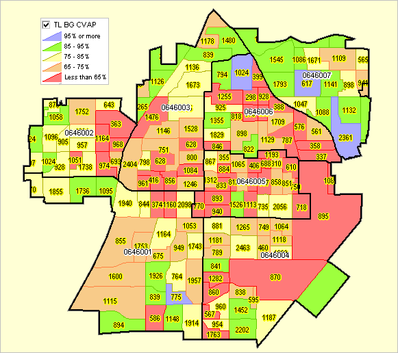
Using VDAGIS -- Open VDA Web GIS with BGs Map/examine block groups using OVDAW .. no login, no fee, nothing to install. Start OVDAW .. view/examine BGs in combination with other geography and subject matter View block groups, examine geodemographic patterns .. find block groups visually by entering a ZIP code (other ways) .. view block groups in context of wide-ranging geography Block Group Demographic-Economic Interactive Table .. goto top Data in table based on ACS 2022 Table includes selected subject matter .. see item list below See Usage notes below table. See about block groups Map/examine block groups using OVDAW .. no login, no fee, nothing to install. Start OVDAW Usage Notes Table contains rows for Census 2020 block groups with ACS 2022 attributes. Negative values indicate estimate not available. Click ShowAll button between queries. Sort the table descending/acsending on any column header. Examine only those BGs is a selected county. Negative values indicate that items for that BG could not be estimated. Example: enter FIPS StateCounty code (5 numeric characters) in Find StCty edit box & click Find button. .. default value is 06059 (Orange County, CA) .. click ShowAll then Find StCty to find attributes of BGs in thie county .. there are 2,049 Census 2020 BGs in this county .. 85 of these BGs have a Median Housing Value($MHV) of $2,000,000 or more (the top-coded value) .. in 235 BGs the $MHV could not be estimated (negative value); some likely exceed the $2,000,000 top-code. Button/Tool Usage .. controls below table Click ShowAll Button Key in desired tract codes Click "Select up to 5 Tracts (enter Tract)>" button. .. table refreshes showing attributes of BGs only in those tracts. .. in the default example there are 16 BGs in these 5 tracts. Click CVAP button; table refreshes showing only these columns for these BGs .. click header "%CVAP Age18up" .. table refreshes showing lowest (44.6%) to highest (89.2%) value. Copy a Row & Paste in Spreadsheet Click a Row (block group), it turns blue. Right-click in blue, choose copy to clipboard (or ctrl-C). Click to Open this Excel file. .. depending on ypour settings, it might be necessary to download then open this file. When Excel file opens, click Ctrl-V in cell A1. Done, optionally add other BGs. View Table in VDAGIS Tools under development Examining a Set of Census Tracts Use the "Select up to 5 Tracts (enter Tract)>" button below the table to select BGs only in designated tracts. the default tract codes are in Santa Ana, CA city and intersect with Congressional Community 0646005 .. state 06, congressional district 46, congressional community 005. Note that the census tract code is 11 characters as defined for Census 2020. .. the block group (BG) code is 12 characters .. the first 11 are the census tract containing that BG. .. see more about block groups Visually Relating Block Groups & Tracts The following view shows two whole tracts in Santa Ana with yellow tract geocodes .. black boundaries: 06059074602 and 06059074501 Component block groups are shown for each tract .. brown bold boundaries with geocodes as white labels .. the ACS 2022 CVAP is shown as a white label under the BG geocode. BGs are shown as a CVAP thematic pattern map; see color to value intervals in inset legend. 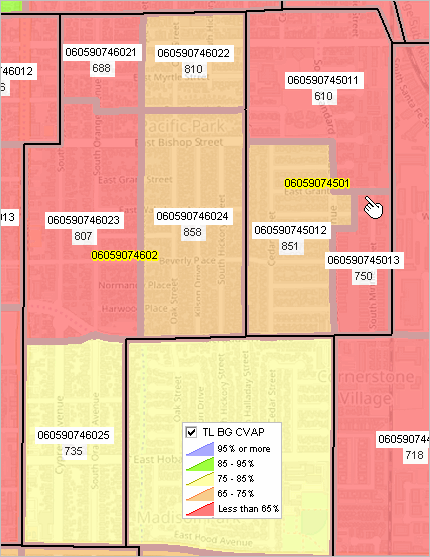 Table Items/Column Headers - Block Group (GEOID, geocode) - State - Total Population - Male Population - Female Population - White alone - Black alone - AIAN alone - Asian alone - NHOPI alone - Other race - Multi race - Hispanic - Age 0-4 Male - Age 5-9 Male - Age 10-14 Male - Age 15-17 Male - Age 0-4 Female - Age 5-9 Female - Age 10-14 Female - Age 15-17 Female - Age 0-17 - Age 18up - Age 65up - Population in Households - Households - Families - Age 25up - Educational Attainment High School Male - Educational Attainment Bachelors Male - Educational Attainment Masters Male - Educational Attainment Professional Male - Educational Attainment Doctorate Male - Educational Attainment High School Female - Educational Attainment Bachelors Female - Educational Attainment Masters Female - Educational Attainment Professional Female - Educational Attainment Doctorate Female - Citizen Voting Age Population Total - Citizen Voting Age Population Age 18-29 - Citizen Voting Age Population Age 30-44 - Citizen Voting Age Population Age 45-64 - Citizen Voting Age Population Age 65-up - Housing Units - Owner Occupied - Renter Occupied - Vacant - Median Hshld Income - Median Family Income - Median Housing Value - Median Rent - CVAP as percent of Age 18up Scope of Subject Matter - categories The above items are a small part of the subject matter available for these geographies. The following table shows a summary of avaiaable subject matter categories.
ProximityOne User Group Join the ProximityOne User Group to keep up-to-date with new developments relating to metros and component geography decision-making information resources. Receive updates and access to tools and resources available only to members. Use this form to join the User Group. Support Using these Resources Learn more about accessing and using demographic-economic data and related analytical tools. Join us in a Data Analytics Lab session. There is no fee for these one-hour Web sessions. Each informal session is focused on a specific topic. The open structure also provides for Q&A and discussion of application issues of interest to participants. Additional Information ProximityOne develops geodemographic-economic data and analytical tools and helps organizations knit together and use diverse data in a decision-making and analytical framework. We develop custom demographic/economic estimates and projections, develop geographic and geocoded address files, and assist with impact and geospatial analyses. Wide-ranging organizations use our tools (software, data, methodologies) to analyze their own data integrated with other data. Follow ProximityOne on Twitter at www.twitter.com/proximityone. Contact us (888-364-7656) with questions about data covered in this section or to discuss custom estimates, projections or analyses for your areas of interest.
|