
|
|
|
|
Sacramento, CA 2010 census tract 06067001101 (or tract 0011.01 in FIPS state+county code 06067) disappeared in 2020. Yes and no. For Census 2020, the 2010 census tract was split and became part of 2020 census tract 06067001102 and part of 2020 census tract 06067001103. This type of change is common in areas growing population from 2010 to 2020. Census 2010 demographics are still available for Census 2010 tract 06067001101 but there are no Census 2020 data for that tract code. To relate changing tract boundaries between 2010 and 2020, which is common, you will need a 2010 and 2020 tract map and typically more such as how the boundaries vary with geographic footprint and geographic area equivalence. Use the VDA Web GIS to examine the 2020 and 2010 tract layers in the Situation & Outlook project. Use the interactive table below to compare tracts in a tabular/geographic area manner. Census tracts are statistical geographic areas and subdivisions of counties (or county equivalent). Census tracts cover the U.S. from wall-to-wall. Each county is comprised of one or more census tracts. There are 84,414 Census 2020 census tracts for which Census 2020 and ACS 2020 demographic data are tabulated (states and D.C.). Examining Census 2020 Tracts Using VDA GIS Use VDA Web GIS to develop views similar to the graphic shown below for your areas of interest. The two highlighted Census 2020 tracts in Sacramento, CA are further reviewed in the interactive table below. VDA shows the tract map view and tract table (an interactive grid) below map. .. find a tract based on address using the Find Address button. .. place a query on the all U.S. tracts file to locate tracts meeting certain criteria. .. click a button below table section to show tracts highlighted in the map. .. click a tract to create a demographic profile 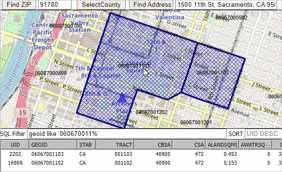 Finding City Containing a Census Tract Using VDA Web GIS Use VDA Web GIS .. start VDA Web GIS .. select County/Regional Trends GIS Project In the top left dropdown, select "Tracts Code" Click Table/Grid button, rightmost button under map window; grid displays. In the SQL Filter box (left below map window) key in the tract filter .. geoid='04013105004' (an example) .. see sample graphic below, not above. .. in real case, use the 11 character tract code of interest. Click the "query" button at right under map window. .. that one tract appears in the grid; click button below grid "highlight all that meet query" .. map view zooms to that location and highlights the tract. In the Legnd Panel, at left of map window check on two layers: .. Cities name and Cities/Towns Pop Trends .. the city name and area are shown .. example showing tract crosshatched in Paradise Valley, AZ. 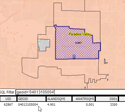 2020 & 2010 Census Tract Equivalence Interactive Table .. goto top Compare Census 2020 tract code (col 1) with Census 2010 tract code (col 6). Census 2020 tracts (states and D.C.) shown with intersecting parts of Census 2010 tracts based on land/water area. Click ShowAll button to refresh/reset; click column header to sort on that column; click again to sort other direction. See ranking table usage notes below table. Usage Notes • The 2020 total population is for the 2020 tract total population. Comparing 2010 and 2020 tracts: • Paste a Census 2020 tract code in Find 2020 tract edit box and click Find 2020 button. .. table refreshes with this 2020 tract code found in column 1. .. click ShowAll button and click Find 2020 tract .. the table is empty. .. there is no 2020 tract code with this value. • Paste a Census 2010 tract code in Find 2010 tract edit box and click Find 2010 button. .. table refreshes with this 2010 tract code found in column 5. .. see there are two instances of this 2010 tract code with this value. .. this tract does not exist in 2020; the 2010 tract with this code was split into 06067001102 and 06067001103. Related sections • census blocks and block codes • census block groups and block group codes • Create tract maps; perform tract related geospatial analysis using CV XE GIS desktop software • Create tract maps; perform tract related geospatial analysis using VDA Web GIS • Create demographic datasets using DEDE software .. from Census 2010, Census 2020, ACS annual • boundaries defined by TIGER/Line shapefiles • AddressCoder software .. determine/assign latitude-longitude coordinates to your address data. .. assign tract, block group and block codes to your address data. .. assign subject matter (demographics) to your address data. .. create a shapefile to map your addresses in context of other geography. • Create tract demographic profile based on an address .. Use the LBD tool ... key in an address to find codes/names based on address. .. Get a demographic profile for the address based on the block group or tract. .. Create a shapefile to map the address(s). Census tracts within a county are identified by a 4-digit basic code between 0001 and 9999, and may have a 2-digit suffix ranging from .01 to .98; for example, 6059.02. The decimal point separating the 4-digit basic tract code from the 2-digit suffix is shown in U.S. Census Bureau printed reports and maps. Subject Matter Data Census tracts average 4,000 population and may be disaggregated in census blocks and census block groups. Census tracts cover the U.S. from wall-to-wall. They are the smallest geography for which American Community Survey data are tabulated for all types subject matter tables. Their "hierarchical" structure makes it possible to aggregate subject matter data, such as the population of a certain age, to higher level geography including counties and metros (but not cities and legislative districts, in general). Vintages Census tracts are statistical area geography (as differentiated from political areas). Boundaries and codes may be redefined for each decennial census. Census 2010 tract boundaries and codes will generally remain unchanged until Census 2020. There are a few exceptions. Codes, Geocodes & Referencing A census tract code may not be used more than once in a single county, but it may be used again in a different county in the same state or in a county in a different state. Therefore, a particular census tract within the nation must be identified by: its state, its county, and its tract code. One way this is done by the Census Bureau and by data users is to identify a particular tract using an 11-digit code consisting of a 2- digit code for the state, a 3-digit code for the county (either of which may include one or more "leading" zeros), and 6 digits for the census tract (including any leading zeros, and also two “trailing” zeros in the many cases in which the basic tract code has no suffix). For example, the Office of the California Secretary of State, located at 1500 11th St, Sacramento, CA 95814, can be fully identified by the 11-digit code 06067001101, in which: • States and the territories are identified by a 2-digit code. • Counties within states are identified by a 3-digit code. • Tracts within counties are identified 6-digit code. Combine these codes to uniquely identify a tract in the U.S. (11 characters). For example, the census tract containing the Office of the California Secretary of State, located at 1500 11th St, Sacramento, CA 95814, is uniquely identified by the code 06067001101. In the map views shown below the table, the address has been geocoded using the AddressCoder and is shown as a red marker. 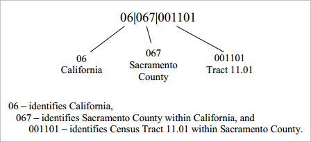
Some ranges of Census 2010 census tract codes are used to identify distinctive types of census tracts. The code range in the 9400s is used for those census tracts with a majority of population, housing, or land area associated with an American Indian area and matches the numbering used in Census 2000. The code range in the 9800s is new for 2010 and is used to specifically identify special land-use census tracts; that is, census tracts defined to encompass a large area with little or no residential population with special characteristics, such as large parks or employment areas. Census tract codes in the 9900s represent census tracts delineated specifically to cover large bodies of water. Map View: Census Tracts Tracts are labeled with green tract codes. Address 1500 11th St, Sacramento, CA 95814 is shown by red marker. 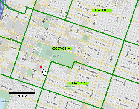 Is the tract code 11.01 or 001101? Both. Census tracts within a county are identified by a 4-digit basic code between 0001 and 9999, and may have a 2-digit suffix ranging from .01 to .98; for example, 6059.02. The decimal point separating the 4-digit basic tract code from the 2-digit suffix is shown in Census Bureau printed reports and maps. For geo-referencing, the decimal point is implied and does not appear; the 6-character tract code with lead zeroes is used -- a character string with no blanks and all numbers. Contact ProximityOne (888-364-7656) with questions about data covered in this section or to discuss custom estimates, projections or analyses for your areas of interest. |
|
|