
|
|
|
Census blocks are "statistical areas bounded by visible features, such as streets, roads, streams, and railroad tracks, and by nonvisible boundaries, such as selected property lines and city, township, school district, and county limits and short line-of-sight extensions of streets and roads." Census block geography and demographics are important for many reasons. • the elemental geography for all decennial census and American Community Survey tabulation areas. • the elemental geography for Congressional Communities. • required for redistricting of Congressional Districts and other political geography. • ideal for location and sub-county territory custom geodemographic analytics. Census 2020 includes 8.2 mllion census blocks covering the U.S. wall-to-wall. Census blocks are the smallest geographic areas for which Census 2020 data are tabulated. Census block geography and geocodes are defined based on the decennial census. Census 2010 census blocks geography and geocodes may differ from Census 2020 census blocks. In general, census block geography and geocodes do not change from census to census. Use the interactive table in this section to view Census 2020 tallies of census tracts, block groups and census blocks. Census blocks are uniquely defined by a 15-character geocode: SSCCCTTTTTTBBBB where: SS state FIPS code . CCC county FIPS code . TTTTTT census tract code . BBBB census block code Explore 2020 Census Blocks & GeoDemographics Using iVDA Tool .. goto top Interactive mapping and data analytics for 8.2 million census blocks iVDA is part of the Visual Data Analytics VDA Geographic Information System (GIS) .. VDA GIS Follow these steps to examine the geodemographics for an address or location in the iVDA frame below. .. step 1: key in "607 Oronoco St, Alexandria, VA" (no quotes) in searchbar above the map; press enter .. the map refreshes with zoom to location shown as blue marker. .. in the legend panel at the left of the map window. - click the Virginia Blocks layer on .. or the state blocks layer containing the address/location. .. the map view zooms to the location and shows it with a blue marker. .. the blocks show with a black boundary. .. click the blue location marker; the 2020 census block containing the marker shows as cross-hatched. .. the profile in the lower left panel shows: - this 2020 census block has geocode 515102018022004 (51-510-201802-2004) with population 58. Try a different address/location ... start with step 1 above. .. maybe 31 Mohegan Ave Pkwy, New London, CT (Coast Guard Academy) Illustrative graphic developed using steps described above 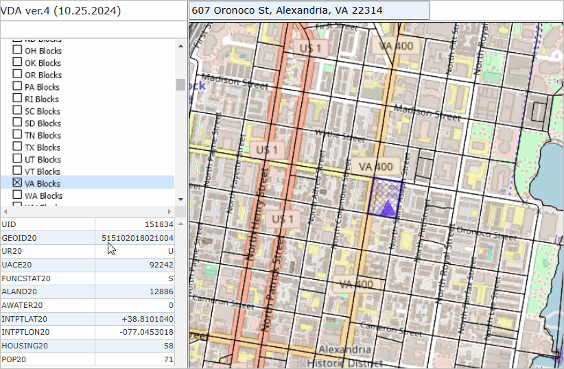
Fields in the VDAGIS Blocks Project State Blocks Layers
GEOID20 - 15 character Census 2020 block geocode
UR20 - 2020 urban/rural status UACE20 - 2020 urban area code FUNCSTAT20 - status ALAND20 - land area SqMt AWATER20 - water area SqMt INTPTLAT20 - Latitude internal point INTPTLON20 - longitude internal point HOUSING20 - 2020 census housing units POP20 - 2020 census population premium version GQ20 - 2020 group quarters population OCCHSG20 - 2020 occupied housing units VACHSG20 - 2020 vacant units HOUSING24 - 2024 housing units OCCHSG24 - 2024 occupied housing units VACHSG24 - 2024 vacant units POP24 - 2024 population GQ24 - 2024 group quarters population POPXX24 - 2024 addiitonal demographics CD119 - 119th Congressional District code CC119 - 119th Congressional Community code PLACE - current city/place code SLDL24 - current state legislative district lower code SLDU24 - current state legislative district upper code SAZ24 - school attendance zone code SD24 - school district code The VDAGIS Blocks Project can be used with any VDAGIS tool. The Blocks Project is comprised of Regions and States layers, state-by-state block layers and a topological base layer. Census 2020 Block Tallies .. goto top Click column header to sort; click again to sort other direction. Using Table/Query Feature .. goto top The iVDA Table/Query feature enables viewing/analyzing the active layer dataset in a grid. If a census block layer, the data for each block are displayed as a row in the grid. This feature is useful to 1) view/use the data in a spreadsheet manner and 2) show selected geographies in the grid in the map view by clicking a button. To start Table/Grid ... 1. select a layer .. click on name in the legend panel and the name highlights blue. 2. click the Table/Grid button below the map window. .. the table/grid now opens and is shown below the map window. .. each row shows a geographic object for the active layer. .. available data fields are arrayed across the columns. Perform a Query & Map Selected Geography .. goto top Select a layer in the legend panel. The DC Blocks layer is used as an example. In the Table/Grid form, enter the query "select geoid20,pop20 where pop20>3000" no quotes. .. this says show two fields for those blocks where the field pop20 is greator that 3000. Enter "pop20 desc" .. no quotes .. in the next edit box as sbown below. Click the Query button and the iVDA form updates as shown below. .. there are two blocks in the DC Blocks layer that have population over 3000. Click the top row to make it the "selected object". Click the "Map 1 selected" button to view this block in the map window. 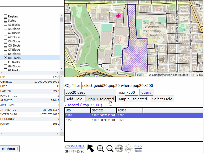
About iVDA VDA GIS resources are developed by Warren Glimpse/ProximityOne/Alexandria, VA USA and Takashi Hamilton/Tsukasa/Osaka, Japan. All that is required to use iVDA is a Web browser. iOS and Android versions are supported. VDA uses the same core structure as the Windows desktop VDA Desktop, the premier version of VDA, offering to manage your own GIS projects, securely and efficently. Related Sections .. goto top • census tracts and tract codes • census block groups and block group codes • boundaries defined by TIGER/Line shapefiles Support Using these Resources Learn more about accessing and using demographic-economic data and related analytical tools. Join us in a Data Analytics Lab sessions. There is no fee for these one-hour Web sessions. Each informal session is focused on a specific topic. The open structure also provides for Q&A and discussion of application issues of interest to participants. ProximityOne User Group Join the ProximityOne User Group to keep up-to-date with new developments relating to geographic-demographic-economic decision-making information resources. Receive updates and access to tools and resources available only to members. Use this form to join the User Group. Additional Information ProximityOne develops geographic-demographic-economic data and analytical tools and helps organizations knit together and use diverse data in a decision-making and analytical framework. We develop custom demographic/economic estimates and projections, develop geographic and geocoded address files, and assist with impact and geospatial analyses. Wide-ranging organizations use our tools (software, data, methodologies) to analyze their own data integrated with other data. Contact ProximityOne (888-364-7656) with questions about data covered in this section or to discuss custom estimates, projections or analyses for your areas of interest. |
|
|