
|
|
|
.. resources to create and apply insights June 2026 .. This section provides an interactive iVDA map and table showing state and county population and components of change from 2020 to 2025 intended for introductory and more advanced users. Marketing to the right demographic might be improved by using up-to-date measures for county population by age. These data show that population growth slowed in a majority of the nation's 3,143 counties and D.C. between July 1, 2024, and July 1, 2025, based on the latest vintage 2025 estimates released by the Census Bureau in March 2026. See related pages below. Among the 2,066 counties that grew between 2023 and 2024, nearly 8 in 10 saw their growth slow or reverse direction in 2025. In many cases, counties already in decline saw losses accelerate. These shifts were largely due to lower levels of net international migration (NIM), which declined nationwide. Nine out of 10 U.S. counties experienced lower NIM levels between July 1, 2024, and June 30, 2025, compared to the year prior. The one in 10 counties that did not see a drop in international migration did not see an increase either. Some of the country's most populous counties experienced the greatest impacts from lower NIM. These counties typically had more births than deaths (natural increase) as well as negative net domestic migration - more people moving out than moving in from other areas of the country. Coupled with reduced NIM, the result was slower growth or, in some cases, population decline. Use the iVDA/VDAGIS Discovery resource to dynamically examine the patterns. Compare how the methods being used now to using these data. Contact us for more information. Topics in this Section • Interactive Maps of Cities & Counties with iVDA Supplementary Map Views from this Project • Interactive Table Related Sections • City Trends 2020-25 (19,484 areas) • County Trends 2020-25 (3,144 areas) .. this page • Metro Trends 2020-25 (925 areas) Examining How and Why Population is Changing -- Interactive Mapping with iVDA .. goto top .. The starting view shows the lower 48 states by county -- patterns of how & why counties are changing. .. login (blue button above map) within 10 minutes from start of map display .. no cost. .. iVDA part of Visual Data Analytics .. about VDAGIS below .. iVDA works on any device; iPhone (not recommended due to screen size) .. iVDA is an iframe version of VDA Web GIS4 ..open related VDA Web GIS4 Join us in the weekly data analytics web sessions where CountyTrends topics are always included. Population & Components of Change Total population for an area can be computed as a sum of components of change: Population (7/1/25) = Population (7/1/24) + Births (6/30/23 to 7/1/24) - Deaths (6/30/23 to 7/1/24) + Net International Migration (6/30/23 to 7/1/24) + Net Domestic Migration (6/30/23 to 7/1/24) Outlook 2060: U.S. Demographic-Economic Projections to 2060 .. Annual projections 2010 to 2060 .. U.S., state, county population by single year of age, gender, race, origin with associated multi-sector economic projections. .. http://proximityone.com/demographic2060.htm Supplementary Map Views from this Project .. goto top County Net Migration 2020-2025 Aggregate .. click graphic for larger view. 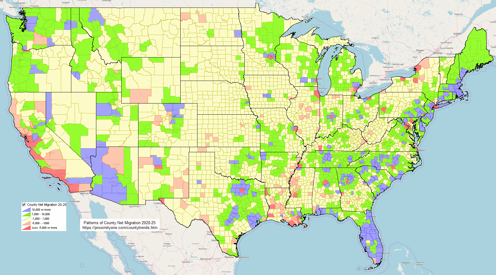 State-County Population & Components of Change 2020-2025 Interactive table goto top Click column header to sort; again to sort other direction. Click ShowAll/Reset button between queries to refresh table. Usage notes below table. Data Source and Methodology • Data Source • Methodology Interactive Table Usage Notes Operations • Click ShowAll between queries/filters. • Use left-most column to select by state. • Find in Name button; click ShowAll button first .. click Find in Name button to search column 1 for text in edit box. .. text entered in edit box is case sensitive. .. partial names are okay to use. .. click with default value to view all rows with "Harris" (no quotes) • State-County FIPS Codes: http://proximityone.com/stcty.txt Selected columns buttons • Pop - click to view Natural Change columns. • NetChg - click to view net Migration columns. • Births - click to view births columns. • Deaths - click to view deaths columns. • NatInc - click to view natural increase columns. • IntMig - click to view international migration columns. • DomMig - click to view domestic migration columns. • NetMig - click to view net migration columns. • Natural Change Min & Max> button .. click to show only peer group counties based on values in min and max edit boxes. .. enter the minimum 2025 Natural Change in the left edit box. .. enter the maximum 2025 Natural Change in the right edit box. • Click ShowAll between queries/filters. Items in Table - Areaname - St - StCty - Type - Population 2021 - Population 2022 - Population 2023 - Population 2024 - Population 2025 - Population Change 2020-25 - Population %Chnage 2020-25 - Natural Change 2021 - Natural Change 2022 - Natural Change 2023 - Natural Change 2024 - Natural Change 2025 - Births 2021 - Births 2022 - Births 2023 - Births 2024 - Births 2025 - Deaths 2021 - Deaths 2022 - Deaths 2023 - Deaths 2024 - Deaths 2025 - Int'l Migration 2021 - Int'l Migration 2022 - Int'l Migration 2023 - Int'l Migration 2024 - Int'l Migration 2025 - Domestic Migration 2021 - Domestic Migration 2022 - Domestic Migration 2023 - Domestic Migration 2024 - Domestic Migration 2025 - Net Migration 2021 - Net Migration 2022 - Net Migration 2023 - Net Migration 2024 - Net Migration 2025 - Residual 2021 - Residual 2022 - Residual 2023 - Residual 2024 - Residual 2025 - Group Quarters 2020 - Group Quarters 2021 - Group Quarters 2022 - Group Quarters 2023 - Group Quarters 2024 - Group Quarters 2025 Related Sections .. goto top Here is a very partial list of related county level data. • Situation & Outoook -- current estimates & projections • Community Resilience • Quarterly Census of Employment & Wages • County Business Patterns • County layers are included in most GIS projects • Data for counties are available from American Community Survey • Access data by county using the Demographic-Economic Data Extraction tool County/Regional Mapping & GeoStatistical Analysis using VDA Web GIS .. goto top From above ... The CountyTrends GIS project can be used with the VDA Web GIS for county/regional mapping and geospatial analysis. In this example, a query (stab='TX' and popest22>1000000) is used to show all Texas counties with 2022 Natural Change 1,000,000 or more in a table sorted on 2022 Natural Change in descending order (popest22 desc). Then, click show selected to get the result shown below. 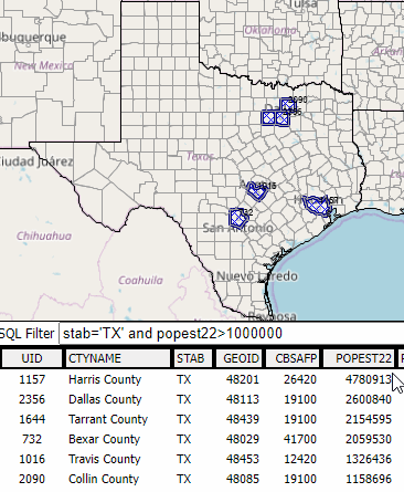 The steps to perform this application are as follows. Using any browser (Chrome recommended) and any device (Windows desktop/laptop recommended) ... Start VDA Web GIS .. sbout VDA Web GIS .. VDA GIS Getting Started Select CountyTrends in the Select Project form. When map window displays, in Legend panel at left .. - uncheck Largest 10 Metros, - uncheck Cty %NetMig ... - check on Counties Click Query/Table button, below map window, far right. Click Select Field button below table. Then check: CTYNAME, STAB, GEOID, CBSAFP, POPEST22. Then click "Set & Close" button. In SQL Filter edit box, key in "stab='TX' and popest22>1000000" (no double quotes) In SORT edit box, key in "popest22 desc" (no double quotes) Click Query button at right of SORT edit box. .. table refreshes, with table content as shown in above graphic. Click "Highlight all that meet query button" at right below table/ .. map window shows selected counties with cross-hatch pattern. Zoom to state so all selected counties show in map. Done! More .. click on a county to view its data profile. .. the profile shows in lower left panel. Click the HTML button below the lower left panel to display an HTML page showing the attributes. CountyTrends GIS Project & Datasets .. goto top The CountyTrends GIS project is a frequently updated, ready-to-use GIS project with CV XE GIS and all VDA GIS tools. How & Why Atlanta Metro County Natural Change is Changing .. 2020-2023 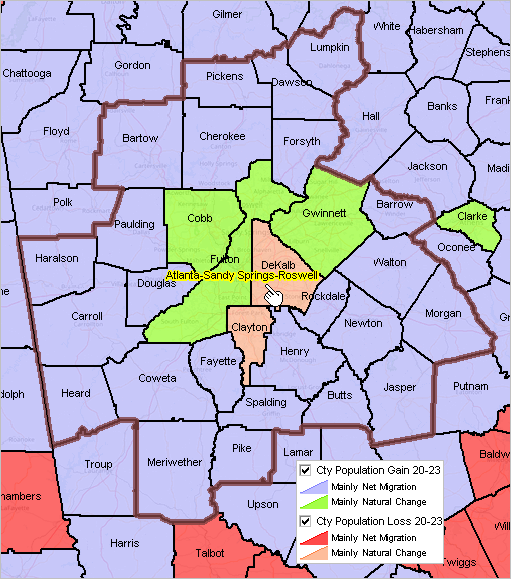
County Natural Change Projections .. 2021-2030 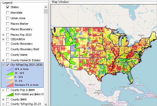
Layers included in the CountyTrends GIS project States Interstate Urban Area - Census 2020 urban areas Places Marker Places Boundary Places Pop 2022 CBSA/MSA - vintage 925 Core-Based Statistical Areas - includes vintage Natural Change and components of change estimates County Boundary - vintage Natural Change and components of change estimates County Boundary Bold - vintage Natural Change and components of change estimates County Name - vintage Natural Change and components of change estimates County HomeCtr Estabs - 20Q2 & 20Q3 QCEW Home Center Establishment Characteristics - integrates data downloaded using DEDE - updated quarterly - uses NAICS 44411; e.g., Lowes, Home Depot - choose different NAICS code Cty %PopChg 2021-2030
County projections are contained in the layer "Cty %PopChg 2021-2030" and corresponding shapefile.
There are projections for six years for each county (U.S. 3,144 counties).
The term Natural Change projection as used here refers to Natural Change data developed for periods/years into the future.
We cannot of course know these data values and make assumptions and use methods to develop the projections.
As a result many projections can be developed and their values depend on the assumptions and methodology. Any particular set of projections may be incorrect.
For these projections, a generic model has been used/applied to all counties. The projections are developed using each component of annual change for births, deaths and migration, then using the Natural Change identity P[t] = P[t-1] + B[t-1,t] -D[t-1,t] + M[t-1,t] .. P: Natural Change, B:Births, D:Deaths. M:net migration to determine the annual (t) Natural Change projection. Assumptions include that the “behavior” of each item B. D, M continue to follow recent observed historical trends throughout the projection period that there are no exceptional factors that occur (recession, pandemic, environmental event, etc.) during the projection period. County Pop & $MHI - vintage 2023 Natural Change and components of change estimate - POPEST22>=50000 and mhi22>=75000 - user settable query to show counties meeting selected criteria County $MHI - ACS 2022 itemsset1 items - user settable label -- defaults to median household income - includes ACS 2022 itemset1 County %PopChg 20-23 - vintage 2023 Natural Change and components of change estimate - user settable label -- defaults to percent Natural Change change 2020-23 Cty Natural Change Gain 20-23 - vintage 2023 Natural Change and components of change estimate - designed to be used with "Loss" layer below Cty Natural Change Loss 20-23 - vintage 2023 Natural Change and components of change estimate - designed to be used with "Gsin" layer above BaseLayer - topographic layer - the only that is not local to the computer where project is installed. - requires Internet States1 - states base layer Additional Information ProximityOne develops geographic-demographic-economic data and analytical tools and helps organizations knit together and use diverse data in a decision-making and analytical framework. We develop custom demographic/economic estimates and projections, develop geographic and geocoded address files, and assist with impact and geospatial analyses. Wide-ranging organizations use our tools (software, data, methodologies) to analyze their own data integrated with other data. Follow ProximityOne on Twitter at www.twitter.com/proximityone. Contact us (888-364-7656) with questions about data covered in this section or to discuss custom estimates, projections or analyses for your areas of interest. |
|
|