
|
|
|
Join us in the weekly web sessions where we review wide-ranging topics on • current and trending geographic-demographic-economic characteristics • tools to access & use demographic-economic data with other data • using decision-making information & developing insights One-hour Data web sessions are conducted by Warren Glimpse. • Tuesdays 3:00 pm ET; Accessing & Using Demographic-Economic Data • Wednesdays 3:00 pm ET; Selected sociometric topics varying by week for leaders, decision-makers, policy-makers, stakeholders needing to understand demographic-economic change for learners & researchers regarding access to and use of tools and data to analyze demographic-economic characteristics & change • Thursdays 3:00 pm ET; GeoSpatial Analytics Visual Data Analytics (VDA) Training & Support • gain insights into information change, patterns that might affect you • see connectivity details below Who benefits? Anyone who is directly or indirectly engaged in accessing/using geographic, demographic, economic data for management, analysis or decision-making. While we cover many technical details, managers and leaders benefit from understanding what is possible even though perhaps not engaged in daily data development or analytics. Topics are heavily cross-related. The thread of small area demographics runs throughout the sessions, even though the main topic might be on congressional districts or cities/counties. The sessions provide a forum for problem-solving and continuity not found elsewhere. E-mail us or call (888-364-7656) with questions/help. ProximityOne develops and uses tools and data to provide fact-based, independent, non-partisan decision-making information to stakeholders on a wide range topics/issues. We focus on accessing, modeling and analyzing geographic, demographic and economic data to better understand recent trends and project future demographic-economic characteristics. 07.14.26. Accessing & Using GeoDemographic-Economic Data Resources .. goto top
Every Tuesday -- 03:00 PM Eastern Time (US and Canada)
Meeting link: https://us06web.zoom.us/j/85014898649?pwd=TTl4TnYrdUNvZ2x5RVhpREZvU2NPUT09 Meeting ID: 850 1489 8649 -- Passcode: 690129 .. above link & ID the same on Tuesdays through December 2026
Navigating the Website & Accessing Resources
Warren Glimpse ProximityOne -- http://proximityone.com .. we build and apply decision-making information and develop related tools empowering you wglimpse@proximityone.com About this Session This session is designed for a 30 minute presentation and up to 30 minute discussion. .. the Topics section provides session structure but many items have only passing reference. .. details vary by week. Topics Today Statistical and Administrative Release Dates
• 2000-26 Monthly New Authorized Residential Construction
.. 05/05/26 2000Jan - 2026Mar Building Permits File .. 05/14/26 2025 annual data .. 05/24/26 Apr 2026 data .. 06/25/26 May 2026 data .. 07/24/26 June 2026 data .. 3-year monthly example of building permits for Irvine, CA • 04/27/26 -- Census -- CB Smoothed TIGER Vintage 2024 -- release • 04/29/26 -- Congressional Communities -- DA2+ narrative profile see example • 05/05/26 -- Census -- Feb & Mar 2026 Building Permits Released • 05/07/26 -- Census/Education -- 2024 School System Sources & Uses of Funds -- SDFA23 • 05/14/26 -- Census -- 2025 Annual Building Permits Released • 05/14/26 -- Census -- Vintage 2025 City and town (incorporated place and minor civil division) population • 05/14/26 -- Census -- Vintage 2025 National, State, and County housing units • 05/14/26 -- BLS -- Virtual Data Users Conference -- Insights on the U.S. Housing Market & Regional Tremds • 05/28/26 -- Census -- Apr 2026 Building Permits Released • 06/02/26 -- BLS -- QCEW 25Q4 -- https://www.bls.gov/cew/ -- using DEDE • 06/03/26 -- BLS -- April Metropolitan Area Employment and Unemployment (Monthly) • 06/25/26 -- Census -- May 2026 Building Permits Released • 06/25/26 -- Census -- Vintage 2025 County population by age, sex, race, and Hispanic origin • 06/25/26 -- BEA -- GDP (3rd Est), Industries, Corporate Profits, State GDP, and State Personal Income, 25Q1 • 06/25/26 -- NCES -- SYFY 2023 Common Core of Data School-Level Finance Survey (SLFS) • 07/01/26 -- BLS -- May Metropolitan Area Employment and Unemployment (Monthly) • 07/02/26 -- BLS -- June 2026 Employment Situation • 07/14/26 -- BLS -- June 2026 Consumer Price Index • 07/24/26 -- Census -- June 2026 Building Permits Released • 07/29/26 -- BLS -- June Metropolitan Area Employment and Unemployment (Monthly) • 07/29/26* -- Census -- 2024 Annual County Business Patterns; County, ZIP, Congressional District • 08/07/26 -- BLS -- July 2026 Employment Situation • 08/12/26 -- BLS -- July 2026 Consumer Price Index • 08/15/26 -- Census -- July 2026 Address Count Listing Files by Block • 08/25/26 -- Census -- July 2026 Building Permits Released • 08/28/26 -- BLS -- QCEW 26Q1 -- https://www.bls.gov/cew/ -- using DEDE • 09/02/26 -- BLS -- July Metropolitan Area Employment and Unemployment (Monthly) • 09/04/26 -- BLS -- August 2026 Employment Situation • 09/11/26 -- BLS -- August 2026 Consumer Price Index • 09/15/26* -- Census -- ACS 2025 1-year -- using DEDE • 09/24/26 -- Census -- August 2026 Building Permits Released • 09/25/26* -- TIGER 2026 ("TL") digital map database available. • 09/30/26 -- BLS -- August Metropolitan Area Employment and Unemployment (Monthly) • 09/30/26 -- BEA -- GDP (3rd Est), Ind, Corp Profits, St GDP & St Personal Income, 26Q2; St PCE prior year • 10/02/26 -- BLS -- September 2026 Employment Situation • 10/14/26 -- BLS -- September 2026 Consumer Price Index • 10/15/26 -- ProximityOne -- Congressional Communities Quarterly Estimates & Projections -- 10-15-26 release .. 2020Q1 through 2026Q3 estimates; 2026Q4 through 2028Q4 projections; and annual .. based on tract level estimates & projections same period controlled to CC120 configurations .. controlled to CD level; each period • 10/27/26 -- Census -- September 2026 Building Permits Released • 10/28/26 -- BLS -- September Metropolitan Area Employment and Unemployment (Monthly) * estimated date Calendar Week at a Glance ChartGraphics -- Population Pyramids Updates • ChartGraphics State of the States • population trends 1970-2025 -- 55 years of change -- for states • includes Vintage 2025 in harmony with CBSAs, counties, cities • State of the States Starting a Congressional Community • Virginia Congressional District 08 Vintage 2025 County Age, Race/Origin, Gender Data • released by Census 6/25/26 • concludes release of Vintage 2025 series • Vintage 2026 starts in December with 2026 state estimates • Earlier AREG Table CBSA/MSA Population & Components of Change Trends • New .. CBSA/MSA Population & Components of Change Interactive Table and Maps VDA GIS Project Menu Update • VDA GIS Project Menu .. new • VDA GIS Project Menu .. previous CountyTrends • CountyTrends 2020-2025 Interactive Table and Maps CityTrends • CityTrends 2020-2025 Interactive Table and Maps "Decision-Making Information" -- Substack • new Substack • starts later June; on days TWT; free or $5/mo Tuesday - sample- accessing and using decision-making information Wednesday - sample - Congressional Districts and Congressional Communities Thursday - sample - orientation and training on GIS (focus on VDA GIS tools and data)) • mainly text; parallels to this section • outbound by substack email to members of user group plus others (they can opt out) • referenced on Contact Us • the Decision-Making Information substack is released every TWT by email, podcasts and otherwise focused on development, access and use of statistical and adminstrative data in context of demographic, social, economic and housing issues. • no posts have been made yet VDA GIS Desktop Project Conversion • developed a new VDA project conversion routine that generates a ESRI ArcGIS Pro project • in operation now and requires user to have ArcGIS Pro to completely use • developed in part for show and demo at upcoming ESRI mid-July user conference in San Diego • see details about VDA GIS Desktop project conversion Demographic Analytics 2 Status Report • focus on annual itemset1 subject matter; ACS 2024 and historical data • user interface similar to DA (Census 2020) • DA (Census 2020) Web page • DA2 Web page In review, ProximityOne ... • Demographic-Economic Data Explorer • Demographic Analytics -- Census 2020 • Demographic Analytics 2 -- ACS Annual • ChartGraphics What's New ... Vintage 2025 Population Estimates • CityTrends .. new city interactive table and mapping • CountyTrends .. new county interactive table and mapping • Metros What's Ahead, ProximityOne ... (7/15/26) Vintage 2025 State Demographic-Economic-Projections to 2030 and 2030 Congressional Apportionment 120th Congress Congressional Districts • 120th Congressional Districts .. about .. updated to 10 states 06/12/26 • NYT Redistricted States updated 6/11 Examining Congressional Districts and State Legislative Districts Discussion End of Session Supplemental Nutrition Assistance Program (SNAP) • Supplemental Nutrition Assistance Program (SNAP) Bluesky Social Media • https://bsky.app/profile/proximityone.bsky.social -- Signup & follow • Bluesky Main New • Metros Gallery • Variation within Congressional District by Congressional Community • Centenarians 2020 Disneyland 1-mile Circular SiteAnalysis • Bluesky • Discovery --Census Block Demographics -- Disneyland 1-mile Circular SiteAnalysis • Blog ChartGraphics Updates -- Population Pyramids • About ChartGraphics • addition of new 119th Congressional Districts 2024 Population dataset • illustrative HTML output for CA CD 47 • interfaced with Demographic Economic Data Explorer (DEDE) output Statistical Reporting -- possible format for CC data? • ZIP Code 77433 Texas • Laguna Beach Unified School District, CA • 119th Congressional District, CA 47 VDA GIS -- the software and VDA GIS projects -- progress report • iVDA is a derivative of VDAW4; developed with Visual Studio • VDA Desktop is developed with Delphi • VDAW4 feature development Layer Editor Database/Applications S&O Estimates & Projections (and Windows standalone) ChartGraphics (and Windows standalone) • Expansion of VDA Group One Project There are two new layers focused on the 2020-2030 projections that use the same shapefile: .. County Pop 2020-2030 -- the population change 2020 to 2030 .. County Pop 2020-2030 Pct -- the population percent change 2020 to 2030 "Group One" VDA GIS Projects Group One Projects have these properties: .. focused on one/two geographies. .. comprised of approximately 10 layers. .. contain the identical, most recent data for these layers: States .. CBSA/MSA .. Counties .. Cities .. BaseLayer (topology) • Using DEDE to Develop ACS 2023 Foreign Born Datasets DEDE Subject Matter Items File B01001_001E TotPopA23 Total Population B05006_001E FBTotA23 Total Foreign-Born Population in U.S. B05006_139E FBLAA23 Latin America B05006_143E FBCubaA23 Latin America:Caribbean:Cuba B05006_154E FBLACAA23 Latin America:Central America B05006_160E FBLCMexA23 Latin America:Central America:Mexico B05006_164E FBSAA23 South America B05006_165E FBARA23 South America:Argentina B05006_166E FBBOA23 South America:Bolivia B05006_167E FBBRA23 South America:Brazil B05006_168E FBCHA23 South America:Chile B05006_169E FBCOA23 South America:Colombia B05006_170E FBECA23 South America:Ecuador B05006_171E FBGUA23 South America:Guyana B05006_172E FBPEA23 South America:Peru B05006_173E FBURA23 South America:Uruguay B05006_174E FBVEA23 South America:Venezuela B05006_175E FBOTA23 South America:Other* Discussion End of Session 10.07.25. Post session additions:
Topic: AI Summary:
Social Media Content Strategy Update discussed updates to their social media content, including new posts about ACS data, bill increments, and county changes. reviewed a recent post about the 118th Congress and discussed plans to update content for upcoming sessions. shared insights from a meeting with his social media person, who recommended focusing on YouTube Shorts over platforms like Instagram and TikTok due to their restrictive algorithms and policies. expressed interest in creating more YouTube content but noted the time required for development. Demographic Data and Projection Updates presented updated demographic data and projections, including new 2024 ACS data and projections through 2030. demonstrated changes in population growth patterns, particularly in Kaufman County, where births have flattened since 2025. also showed new features in the application, including U.S. summary data and the ability to copy data to Excel, though the latter still needs fixing. mentioned that the name of the section had been changed from "Situation and Outlook Estimates and Projections," but asked him to change it back. SOEP Application Demonstration Overview demonstrated a new application called SOEP, which stands for Situation & Outlook Estimates & Projections. showed how to install and use the application, highlighting its interactive map and various views. mentioned that while the application is ready for use, some information is still incomplete, such as details of operation and methodology. also noted that the application currently only provides county-level data, and considering changing this to a different geographic level. Data Tools and Engagement Strategies discussed a tool that data journalists would find useful, but noted that it was currently not functioning properly. also talked about the potential of using attention-grabbing titles, like "Snakes on a Plane," to increase engagement with CRS reports. mentioned that he would continue working on the centenarians project, which involves census data. Centenarians discussed the concentration of centenarians in North Dakota and South Dakota, noting that Florida has a higher number due to people moving there later in life. 09.23.25. Post session additions: Topic: DEDE 26.1 installer: https://proximityone.com/dede/1/dede261_installer.exe .. requires userid and password Install the DEDE 26.1 application in an otherwise empty folder; e.g. c:\dede261. Topic: Calendar for Data Releases (frequent updates): Calendar updates -- data releases red dots Topic: Session recording: https://us06web.zoom.us/rec/share/zPzzwS-py_TIzWFDUkGQKzSBV-uzZ7KwKPsEQqazELbVv7hVg2lgq4ie5jLuOj0p.Asft3fzvtwYkk-GF Passcode: AEh4GLP* • K-12 Public Schools Characteristics & Analytics .. 2022-23 & 2023-24 .. K-12 Public Schools Characteristics & Analytics .. new: added selected 2023-24 NCES Common Core of Data .. released in December .. examining free and reduced price lunch characteristics by 2023-24 school • Birth and Natality Characterstics and Patterns .. examining births and birth rates by county • Blog Post -- The Importance of Small Area Data .. continuing series .. iVDA Blog Post • Kansas Demographic-Economic Data Analytics -- Updates .. updating VDAGIS project -- added block group layer .. new section on using the iVDA Table/Query with KSDE .. KSDE Section • Census 2020 Block Demographics .. updating VDAGIS project .. housing trends by census block .. Census 2020 Blocks Section • Annual update -- BEA U.S. by County Personal Income by Major Source & related Files .. released 11/14/24 .. annual time series data through 2023 .. being integrated Regional Economic Information System .. key components of analyzing/understanding local area economy and trends • 2010-2020 Intercensal Population Estimates 11/7/24 .. annual time series 2010 through 2020; for states, counties, cities, towns/townshipa .. Intercensal Interactive Table .. being integrated into Regional Economic Information System .. key components of analyzing/understanding local area economy and trends • 119th Congressional District Election Results Interactive Table and related demographics .. frequent election results updates .. integrating ACS 2023 1-year 2023 data, additional Subject matter soon .. integrating Census 2020 DP1 data -- December 2024 .. being integrated into VDAGIS Base project. Application: new incumbents entering Congress 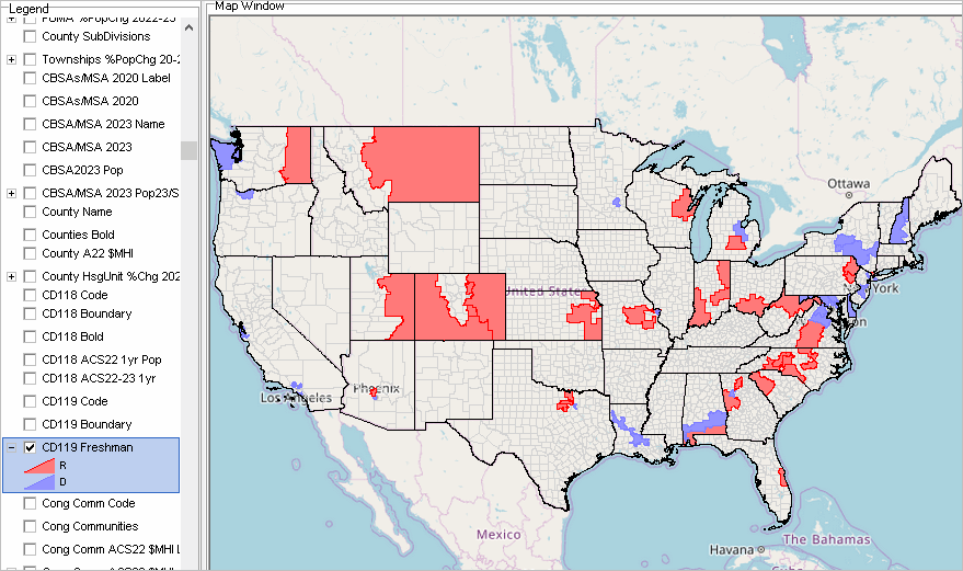 • Updates to the VDAGIS Base Project. .. SLD 2024 layers have been added. .. three (elm, sec, uni) school district layers with school district finances integrated. .. Urban Areas layer showing population change .. TIGER 2024 interstate layer .. TIGER 2024 detailed roads layer (LA & Orange County) .. Public Use Microdata Areas with demographics trends Application: The 400 Myrtle St street segment (see pointer) is a bounding street segment for blocks 060590626052003 and 060590626052002 . Click the street segment to show the street segment profile. 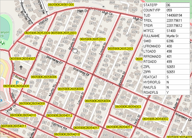 End of Session .. • Using GIS & GeoDemographics Course -- amplify your skillset • Geographic Summary Levels & Geocodes - new section • Census Tracts Main Section updates - updated interactive table • Demographic-Economic Data Explorer (DEDE) updates - creating demographic-economic datasets • Using the Demographic Analytics Tool - creating narrative profiles for your area • 119th Congress Block Equivalency Files .. new this week - integrating the CD code in block shapefiles - adding CC code, selected 2020 pop & hsg items, 2024 hsg and GQ, urban/rural flag, urban area geocode - will be available state by state layers as a VDAGIS project and accessible using most VDAGIS tools. • 119th Congress, 2024 SLDs, ACS Data .. related topics • iVDA updates - new feature -- uploading your shapefile - Knowing Your Neighborhood - Metros - America's Cities - Examining K-12 Schools & School Districts - Congressional Communities & Congressional Districts • Vintage 2025 TIGER/Line files • Hispanic Population by Specific Origin by ZIP Code Area .. https://proximityone.com/hispanic_origin_zip.htm - embedded iVDA interactive mapping; demonstrating new iVDA features - new VDA GIS Hispanic Population by Specific Origin project; acceesible by many VDAGIS tools - blog post • Accessing Healthcare Resources updates -- https://proximityone.com/healthcare_resources.htm - to review next week End of session • Housing Units by Census Block -- 2020-2024 .. Using VDAD with US1_2024 • State Personal Income -- Quarterly PCPI 2020Q1-2023Q4 - integrated iVDA mapping and interactive table - access using VDAGIS Discovery - updates quarterly; next update June 28 • VDAGIS Discovery Updates -- https://proximityone.com/vdagis_discovery • Examining Citizen Voting Age Population (CVAP) new section • America's Cities -- Examining Population Change 2020-2023 .. interactive table • 2023 Population Density by Vintage 2023 Metropolitan Statistical Area  - create views like above graphic using OpenVDA - using only a Web browser; no registration, no login, no fee. • Examining Longitudinal Patterns of Housing Price Index by ZIP Code - HPI by ZIP Code section updated with 2020-2024 HPI  • Examining National Scope Census Block Housing Unit/Demographic Change 2020 to 2024 • VDA GIS Updates - VDA Embedded Beta - VDAW - OVDAW .. OpenVDA - VDA Desktop .. VDAD - GeoSelect/Site Analysis feature updated in all VDAGIS tools - Base Project updates .. available by all VDAGIS tools • Dependency Ratio by Neighborhood/Census Tract - new dependency ratio web section - added VDA GIS Base project • Diversity Index by Neighborhood/Census Tract - about the diversity index - added VDA GIS Base project • DEDE3 updates • DA2 updates • Citizenship & Voting - Citizenship Data from ACS2020 regular program - Citizen Voting Age Population ACS 2022 Special Tabulation - Citizenship & Voting Data from the Current Population Survey • New annual estimates of housing units authorized by building permits - released May 1, 2024: U.S., Region, State, Metropolitan Area, County, and Place - new annual 2023 data - revised annual 2022 data 04.30.24. Topics • DEDE3 updates • How & Why Michigan Demographics are Changing - state by state sections developed in upcoming months • How & Why County Demographics are Changing - interactive table • CountyTrends GIS Project • Demographic Analytics 2 updates & illustrative views - These web-based HTML versions can also be created using in XLS format using DA2. - illustrative views - select ACS 1-year or 5-year data - census tract up by summary level Recent Topics 04.16.24. Topic .. How & Why Metropolitan Areas are Changing - updated main page, new interactive table, metro demographic change included in VDAGIS Base project Did you know .. among the 15 2023 vintage Michigan Metropolitan Statistical Areas .. six increased in population during 2020-2023, one had no change, and eight lost population? .. learn how and why this change has occurred. 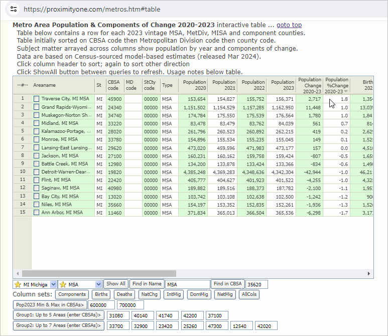 The Detroit MSA, its two component Metropolitan Divisions, the MSA component counties. 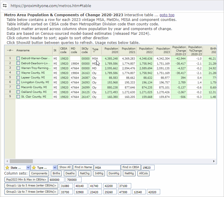 04.09.24. Topic .. Mobility .. 1-year migration based on residence one year ago - developing for places using ACS 2022 04.02.24. Topic .. Language Spoken at Home (LSAH) - developing for counties using ACS 2022 03.26.24. Topic .. Examining the School District Community - Clark County School District Topic 2 .. Updates to the VDAGIS "Base" project - . Click to start Open VDA Web GIS featuring the Base project 03.19.24. Topic .. Migration .. how & why county population is changing - developing for counties using Vintage 2023 model-based estimates 03.12.24. Topic .. Examining the Daytime (commuter adjusted) Population - developing for places using ACS 2022 - reviewing computation and data required - creating dataset using DEDE - file created: C:\dede\api_items_acs22_daytime_places.dbf - modify file: Commuter-adjusted population = Total resident population + Total workers working in area - Total workers living in area. - integrate shapefile into places shapefile using CVXEGIS Database>dBMerge - add shapefile to GIS project, adjust layer, show in map: • Migration .. how & why county population is changing - examining county/metro demographic change using Vintage 2023 model-based estimates How & Why County Population Has Changed 2020-2023 
Selected County Profiles - Fresno, CA - Orange, CA - Los Angeles, CA - Harris County, TX Using US1 GIS project to examine county/metro population & components of change • New Tracts 2022 Web section/page & interactive table - dataset integrated into VDAGIS Base project • Open VDA Web GIS CD review/update; very similar to Open VDA Web GIS • Demographic Analytics (DA) updates - tabular & narrative comparative analysis reports • Demographic Economic Data Explorer (DEDE) updates - DEDE2 - ACS time series & geocomposite - DEDE-DP Update -- Demographic Economic Data Explorer - Data Profiles .. demo of work-in-progress - dbtools/dbf development added; all school districts added - illustrative DP views: DP5 General Demographics .. DP2 Social .. DP3 Economic .. DP4 Housing • ChartGraphics update/review -- population pyramids • January 2024 Place/County Building Permits time series monthly update; new data released 02.26.24 Using VDAGIS to Promote Community Business Growth See related section
By establishing areas that promote economic development, qualified entities can encourage and sustain business growth in
their communities. Federal programs available to facilitate such investment and growth are the Opportunity Zones and HUBZones.
The following map illustrates how VDAGIS tools can be used to examine qualified areas in the Atlanta region. The view shows block groups. Block group areas may be of interest to applicants and investors in understanding and documenting demographic-economic characteristics. 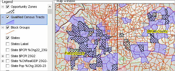
Opportunity Zones An Opportunity Zone is an economically distressed area where new investments may be eligible for certain tax benefits. There are 8,764 Opportunity Zones spread throughout the 50 states, DC and five U.S. territories. HUBZones The HUBZone program creates incentives (called "preferences") for federal agencies to purchase goods and services from businesses that operate and employ people in areas designated as HUBZones. The acronym HUB stands for "Historically Underutilized Business," and a HUBZone is a historically underdeveloped business zone that meets one or more of five defined criteria. HUBZones are mainly areas that are Qualified Census Tracts. Upcoming Topics: Demographics Today: • Migration • Climate Change impact • School District Community Release dates: • 03.06.24. QCEW 2023Q3 Quarterly .. this table update; VDAGIS Base project updates • 03.14.24. Census Model-based Vintage 2023 County Population Estimates & Components of Change .. this table update; VDAGIS Base project updates • 04.15.24. ProximityOne 2024 Q2 S&O Estimates & Projections Recent: • Block Groups ACS 2022 Interactive Table .. about Block Groups • Voter Demographic Analytics • Finding & Viewing a Census Tract .. Blog topic • Demographic-Economic Data Explorer .. DEDE updates • Vintage 2023 Population Estimates for the U.S. & States with Components of Change - released 12/19/23 see below - added to VDAGIS Base • Using Demographic Analytics with Remote Desktop Service (P1 WinServer) - nothing to install; use with PC, Mac, iOS, other - use narrative for talking points; tell a story - requires app add request • vintage TIGER Digital Map Database updates Topics - 01 Federal GeoStatistical System - 02 Selected News Items - 03 Geography: Summary Levels & TIGER - 04 K-12 Education & School Districts - 05 Congressional Districts, State Legislative Districts, Congressional Communities - 06 Metros, Counties, Cities, Towns - 07 Neighborhoods, Census Tracts - 08 Population, Births, Deaths, Migration Annual Estimates - 09 Housing & Real Estate - 10 Income & Poverty - 11 GDP & Personal Income - 12 Labor Force & Employment - 13 Inflation & Cost of Living - 14 Establishments, Employment, Wages - 15 Energy & Environment - 16 Banking & Finance - 17 Crime & Social - 18 Health & Healthcare Selected Statistical Programs - 19 American Community Survey (ACS) - 20 Census 2020 - 21 Current Population Survey - 22 Using Open VDA Web GIS - 23 Using VDA Desktop GIS (VDAD) - 24 Demographic Analytics - 25 Demographic-Economic Data Explorer - 26 Regional Economic Information System - 27 Situation & Outlook Estimates & Projections - 28 Selected Recent & Upcoming Data Releases; Tuesday Session Programs Ahead 01. Federal GeoStatistical System .. goto topics .. The Federal GeoStatistical System .. a dynamic "book" - weekly updates in the Tuesday session - section recaps shared in Tuesday session roughly monthly - only available here until possible "printed" copy in ~spring 2024 - only here .. dialoging on topics of interest .. Overview .. multi-sourced data access and integration .. what is where and how to access it; variations on public data structures 02. Selected News Items .. goto topics 12.19.23. Vintage 2023 Population Estimates for the U.S. and States with Components of Change .. start of 2023-24 annual cycle 12.07.23. GDP by County, Metro .. series through 2022 .. released 12/07/23 .. Regional Economic Information System 12.07.23. ACS2022 5-year estimates .. annual update 12.01.23. Vintage 20230 TIGER Digital Map Database released .. annual update 11.16.23. Personal Income by County, Metro .. series through 2022 .. released 11/16/23 .. Regional Economic Information System 11.09.23. Census Releases Population Projections to 2100 .. U.S. national scope only .. Datasets .. Projected Population by Year, Matrix 03. Geography: Summary Levels & TIGER .. goto topics 3.1. Selected Geography .. access data for these area using Demographic Analytics tool .. Summary Levels - Census Blocks (100) limited scope demographics available only from decennial census - Block Groups (150) richer demographics, smallest tabulation area available from annual ACS 5-year program - Census Tracts (140) yet richer demographics, available from decennial census & annual ACS 5-year program current estimates and projections available from ProximityOne Situation & Outlook program - Counties (050) above three geographies nest within counties - Metropolitan Statistical Areas (3XX) .. CBSAs above four geographies nest within CBSAs Core-Based Statistical Areas - Urban Areas (400) - Cities/Places (160) - Congressional Districts (500) - Congressional Communities (501) - ZIP Codes (860) - School Districts (9xx) 3.2. TIGER Digital Map Database .. main section 04. K-12 Education & School Districts .. goto topics Summary level 9xx .. CCD .. RCNE .. School District Community Getting Your School District Total Population from ACS 2022 .. what is ACS 2022; why ACS 2022 1-year? when not to? .. illustration for Lexington School District 5, SC .. Step 1 .. get the school district code .. Step 2 .. use the API .. api call: https://api.census.gov/data/2022/acs/acs1?get=NAME,B01001_001E&for=school%20district%20(unified):02820&in=state:45 .. return: [["NAME","B01001_001E","state","school district (unified)"], .. return: ["Lexington School District 5, South Carolina","107290","45","02820"]] 2022 population for Lexington School District 5, SC: 107,290 05. Congressional Districts & Congressional Communities .. goto topics .. Congressional Districts .. summary level 500 .. Congressional Communities .. summary level 501 - 06 Metro, Counties, Cities, Towns - 07 Neighborhoods, Census Tracts 06. Metros, Counties, Cities, Towns .. goto topics 07. Neighborhoods, Census Tracts .. goto topics 08. Population, Births, Deaths, Migration Annual Estimates .. goto topics 8.1. County Annual Estimates .. Census sourced 8.2. Migration .. annual county estimates interactive table .. DEDE County Profile .. Fresno County, CA report section 3.1 .. Fresno County, CA Movers Dataset (XLS) annual; most recent year 2020 ACS 5-year based .. State-to-State Migration Flows ACS 2022 1-year 8.3. Urban/Rural .. Urban/Rural 2020 8.4.Vintage 2023 Population Estimates for the U.S. & States with Components of Change .. July 1, 2023 with corresponding annual estimates and components of change since 2020 Census. .. start of vintage 2023 estimates culminating in June 2024 09. Housing & Real Estate .. goto topics .. Annual Census Estimates .. Building Permits, monthly/annual 10. Income & Poverty .. goto topics .. Small Area Income and Poverty Estimates .. 11. GDP & Personal Income .. goto topics .. GDP .. Personal Income 12. Labor Force & Employment .. goto topics .. BLS programs .. Census programs .. BEA programs 13. Inflation & Cost of Living .. goto topics .. CPI .. PCE 14. Establishments, Employment, Wages .. goto topics .. BLS QCEW .. Census CBP 15. Energy & Environment .. goto topics .. 16. Banking & Finance .. goto topics .. FDIC .. FFIEC 17. Crime & Social .. goto topics .. BJS 18. Health & Healthcare .. goto topics .. HHS 19. American Community Survey (ACS) .. goto topics .. main section .. ACS 2022 20. Census 2020 .. goto topics .. main section 21. Current Population Survey (CPS) .. goto topics .. BLS CPS main .. Census CPS main .. Monthly Supplements ASEC .. Annual Demographic File 22. Using Open VDA Web GIS & Base project .. goto topics .. click here to start .. see more about .. as shown in the graphic below. .. no fee, no login, nothing to install, any browser, desktop recommended.  Layers in Base Project -- recently added layers/subject matter
States
New Interstate New State $PCPI %Chg22_23Q2 New State $PCPI 23Q2 State PCRealGDP 2023Q1 New K-12 Schools Elem New K-12 Schools Middle New K-12 Schools High CBSAs/Metros/MSAs Label CBSAs/Metros/MSAs Cong District Code Cong Districts Cong Districts Bold Cong Comm Label Cong Communities Cong Communities Div Lbl Cong Communities Diversity Cong District Diversity Label Cong District Diversity CD 118 PopChg% 2020-22 St Leg Dist Upper St Leg Dist Lower School Districts Label Replaced School Districts Urban Areas Label Urban Areas ZIP Codes Label ZIP Codes County Name Counties1 Counties2 Cities/Places Label Cities/Places Cty Population Gain 2020-22 Cty Population Loss 2020-22 Tracts Label Tracts DP1 Label Tracts DP1 %Age 65+ Tracts ACS $MHI Tracts LMI23 Label Tracts LMI23 MFI Tract/MSA% BaseLayer States1 23. Using VDA Desktop GIS (VDAD) .. goto topics .. VDAD Installer .. click to run .. updated 11/07/23; shows as version 11.08.23 .. TIGERweb Web Map Service (WMS) .. illustrative appplication 24. Demographic Analytics .. goto topics .. Demographic Analytics main 25. Demographic-Economic Data Explorer .. goto topics .. new DEDE2 & Installer .. about DEDE2 .. run DEDE2 installer .. DEDE compared to DEDE2 .. DEDE Guide updates .. http://proximityone.com/dede_guide/guide .. DEDE Installer Updated .. run DEDE installer .. software not updated but ACS 2021 and 2022 subject matter items files (SMIF) have been updated. .. see ACS 2021 SMIF used for the start-up display .. similar to ACS 2022 SMIF .. items scroll section:
Each of these files include these newly added age fields:
B01001_003E A0004MA22 Male: Under 5 years B01001_004E A0509MA22 Male: 5 to 9 years B01001_005E A1014MA22 Male: 10 to 14 years B01001_006E A1517MA22 Male: 15 to 17 years B01001_027E A0004FA22 Female: Under 5 years B01001_028E A0509FA22 Female: 5 to 9 years B01001_029E A1014FA22 Female: 10 to 14 years B01001_030E A1517FA22 Female: 15 to 17 years enabling computation of the dependency ratio. They also include these newly added educational attainment fields B15002_011E EAHSMA22 Male: High school graduate (includes equivalency) B15002_015E EABMA22 Male: Bachelor's degree B15002_016E EAMMA22 Male: Master's degree B15002_017E EAPMA22 Male: Professional school degree B15002_018E EADMA22 Male: Doctorate degree B15002_028E EAHSFA22 Female: High school graduate (includes equivalency) B15002_032E EABFA22 Female: Bachelor's degree B15002_033E EAMFA22 Female: Master's degree B15002_034E EAPFA22 Female: Professional school degree B15002_035E EADFA22 Female: Doctorate degree Enabling new ability to create percentages of educational attainment by highest EA level They also include these newly added citizen fields: B29001_001E VATOTA22 Total Citizen, Voting-Age Population B29001_002E VA1829A22 Total Citizen, Voting-Age Population 18 to 29 years B29001_003E VA3044A22 Total Citizen, Voting-Age Population 30 to 44 years B29001_004E VA4564A22 Total Citizen, Voting-Age Population 45 to 64 years B29001_005E VA65UPA22 Total Citizen, Voting-Age Population 65 or more years Enabling analysis of age-based citizen voting age population 26. Regional Economic Information System (REIS) .. goto topics 26.1. REIS Main Section .. reviewing new county level 2022 personal income data released 11/16/22 .. reviewing updated REIS software package 26.2. U.S. & State Quarterly Personal Income Components Dataset .. 6 BEA sourced datasets developed into a standardized structure running from 2010Q1 through 2023Q2 .. to be restructured some in the week or two ahead .. other series to be added .. data reflect a comprehensive update that was finalized this fall .. using these and related data to simulate projection of the 2023Q3 data to be released by BEA in December .. also in December, BEA will release similar annual time series data at the county level thru 2022 Scope of Subject Matter .. Corresponding County Level Components .. Table CA4 - Personal Income by Major Source .. Table CA5 - Earnings by Source & Sector .. Table CA25 - Employment by Sector .. Table CA30 - Economic Profile .. Table CA35 - Transfer Payments 27. Situation & Outlook Estimates & Projections Overview .. goto topics See S&O Calendar 28. Selected Recent & Upcoming Data Releases; Tuesday Session Programs .. goto topics 09.06.23. QCEW Quarterly 2023Q1 U.S. by County Establishments, Employment, Earnings (BLS) - updated quarterly/annual time series by type of business/NAICS - related Regional Economic Information System 10.04.23. Personal Consumption Expenditures by State, 2022 11.16.23. Personal Income by County and Metropolitan Area, 2022 (BEA); updated annual time series - related Regional Economic Information System 12.07.23. QCEW Quarterly 2023Q2 U.S. by County Establishments, Employment, Earnings (BLS) - updated quarterly/annual time series by type of business/NAICS - related Regional Economic Information System 12.07.23. Gross Domestic Product by County and Metropolitan Area, 2022 (BEA); updated annual time series - related Regional Economic Information System 12.07.23. 2022 American Community Survey 5-year estimates (Census); data to block group level - related 2022 American Community Survey 12.14.23. Real Personal Consumption Expenditures by State and Real Personal Income - by State and Metropolitan Area, 2022 12.15.23. 2022 Small Area Income and Poverty Estimates (Census); school district & county - related SAIPE 12.22.23. Gross Domestic Product by State and Personal Income by State, 3rd Quarter 2023 01.15.24. U.S. by County Population by Age, Race/Ethnicity, Gender Annual Projections to 2060 (ProximityOne) - aggregates to metro, state & U.S. - related Demographics 2060 01.15.24. Situation & Outlook Quarterly Release 01.25.24. K-12 School & School District Administrative Data release (NCES/CCD) - data for 2022-23 school year 03.08.24. QCEW Quarterly 2023Q3 U.S. by County Establishments, Employment, Earnings (BLS) - updated quarterly/annual time series by type of business/NAICS - related Regional Economic Information System 04.15.24. Situation & Outlook Quarterly Release 03.31.24. Gross Domestic Product by State and Personal Income by State, 4th Quarter 2023 and Year 2023 (Preliminary) 07.15.26. Examining Congressional Districts & Congressional Communities .. goto top .. accessing and using the latest small area data. Wednesday -- 03:00 PM Eastern Time (US and Canada) Meeting link: https://us06web.zoom.us/j/85954760288?pwd=fENb51ZjoOZ27bYFHJlrXPVbGHEVEn.1 Meeting ID: Meeting ID: 859 5476 0288 .. Passcode: 564716 .. above link & ID the same on Wednesdays through December 2026
Welcome! .. goto interactive mapping below
Adding More Recent Building Permits DataIntroductions Warren Glimpse ProximityOne -- http://proximityone.com .. we build and apply decision-making information and develop/operate/provide tools for related data access/integration/analysis wglimpse@proximityone.com Dan Carracino Founder, Congressional Communities .. about Congressional Communities .. https://congressionalcommunities.org dan@congressionalcommunities.org Who this session is for and how you benefit .. leaders, decision-makers, policy-makers, stakeholders needing to understand demographic-economic change .. learners & researchers regarding access to and use of tools and data to analyze demographic-economic characteristics & change • Site Navigation • SiteMap • Register to receive these weekly updates by e-mail. This session includes the topics listed below. .. illustrative applications focused selected geography & subject matter .. ask questions/dialog as we go .. ~30 minute presentation followed by discussion. Topics Today Statistical and Administrative Release Dates
• 2000-26 Monthly New Authorized Residential Construction
.. 05/05/26 2000Jan - 2026Mar Building Permits File .. 05/14/26 2025 annual data .. 05/24/26 Apr 2026 data .. 06/25/26 May 2026 data .. 07/24/26 June 2026 data .. 3-year monthly example of building permits for Irvine, CA • 04/27/26 -- Census -- CB Smoothed TIGER Vintage 2024 -- release • 04/29/26 -- Congressional Communities -- DA2+ narrative profile see example • 05/05/26 -- Census -- Feb & Mar 2026 Building Permits Released • 05/07/26 -- Census/Education -- 2024 School System Sources & Uses of Funds -- SDFA23 • 05/14/26 -- Census -- 2025 Annual Building Permits Released • 05/14/26 -- Census -- Vintage 2025 City and town (incorporated place and minor civil division) population • 05/14/26 -- Census -- Vintage 2025 National, State, and County housing units • 05/14/26 -- BLS -- Virtual Data Users Conference -- Insights on the U.S. Housing Market & Regional Tremds • 05/28/26 -- Census -- Apr 2026 Building Permits Released • 06/02/26 -- BLS -- QCEW 25Q4 -- https://www.bls.gov/cew/ -- using DEDE • 06/03/26 -- BLS -- April Metropolitan Area Employment and Unemployment (Monthly) • 06/25/26 -- Census -- May 2026 Building Permits Released • 06/25/26 -- Census -- Vintage 2025 County population by age, sex, race, and Hispanic origin • 06/25/26 -- BEA -- GDP (3rd Est), Industries, Corporate Profits, State GDP, and State Personal Income, 25Q1 • 06/25/26 -- NCES -- SYFY 2023 Common Core of Data School-Level Finance Survey (SLFS) • 07/01/26 -- BLS -- May Metropolitan Area Employment and Unemployment (Monthly) • 07/02/26 -- BLS -- June 2026 Employment Situation • 07/14/26 -- BLS -- June 2026 Consumer Price Index • 07/24/26 -- Census -- June 2026 Building Permits Released • 07/29/26 -- BLS -- June Metropolitan Area Employment and Unemployment (Monthly) • 07/29/26* -- Census -- 2024 Annual County Business Patterns; County, ZIP, Congressional District • 08/07/26 -- BLS -- July 2026 Employment Situation • 08/12/26 -- BLS -- July 2026 Consumer Price Index • 08/15/26 -- Census -- July 2026 Address Count Listing Files by Block • 08/25/26 -- Census -- July 2026 Building Permits Released • 08/28/26 -- BLS -- QCEW 26Q1 -- https://www.bls.gov/cew/ -- using DEDE • 09/02/26 -- BLS -- July Metropolitan Area Employment and Unemployment (Monthly) • 09/04/26 -- BLS -- August 2026 Employment Situation • 09/11/26 -- BLS -- August 2026 Consumer Price Index • 09/15/26* -- Census -- ACS 2025 1-year -- using DEDE • 09/24/26 -- Census -- August 2026 Building Permits Released • 09/25/26* -- TIGER 2026 ("TL") digital map database available. • 09/30/26 -- BLS -- August Metropolitan Area Employment and Unemployment (Monthly) • 09/30/26 -- BEA -- GDP (3rd Est), Ind, Corp Profits, St GDP & St Personal Income, 26Q2; St PCE prior year • 10/02/26 -- BLS -- September 2026 Employment Situation • 10/14/26 -- BLS -- September 2026 Consumer Price Index • 10/15/26 -- ProximityOne -- Congressional Communities Quarterly Estimates & Projections -- 10-15-26 release .. 2020Q1 through 2026Q3 estimates; 2026Q4 through 2028Q4 projections; and annual .. based on tract level estimates & projections same period controlled to CC120 configurations .. controlled to CD level; each period • 10/27/26 -- Census -- September 2026 Building Permits Released • 10/28/26 -- BLS -- September Metropolitan Area Employment and Unemployment (Monthly) * estimated date Calendar Week at a Glance Examining Congressional Districts and State Legislative Districts 120th Congress Congressional Districts • 120th Congressional Districts .. about .. updated to 10 states 06/12/26 • NYT Redistricted States updated 6/11 ChartGraphics -- Population Pyramids Updates • ChartGraphics State of the States • population trends 1970-2025 -- 55 years of change -- for states • includes Vintage 2025 in harmony with CBSAs, counties, cities • State of the States Starting a Congressional Community • Virginia Congressional District 08 Vintage 2025 County Age, Race/Origin, Gender Data • released by Census 6/25/26 • concludes release of Vintage 2025 series • Vintage 2026 starts in December with 2026 state estimates • Earlier AREG Table CBSA/MSA Population & Components of Change Trends • New .. CBSA/MSA Population & Components of Change Interactive Table and Maps VDA GIS Project Menu Update • VDA GIS Project Menu .. new • VDA GIS Project Menu .. previous CountyTrends • CountyTrends 2020-2025 Interactive Table and Maps • County Net Migration 2020-2025 Aggregate small • County Net Migration 2020-2025 Aggregate large CityTrends • CityTrends 2020-2025 Interactive Table and Maps "Decision-Making Information" -- Substack • new Substack • starts later June; on days TWT; free or $5/mo Tuesday - sample- accessing and using decision-making information Wednesday - sample - Congressional Districts and Congressional Communities Thursday - sample - orientation and training on GIS (focus on VDA GIS tools and data)) • mainly text; parallels to this section • outbound by substack email to members of user group plus others (they can opt out) • referenced on Contact Us • the Decision-Making Information substack is released every TWT by email, podcasts and otherwise focused on development, access and use of statistical and adminstrative data in context of demographic, social, economic and housing issues. • no posts have been made yet VDA GIS Desktop Project Conversion • developed a new VDA project conversion routine that generates a ESRI ArcGIS Pro project • in operation now and requires user to have ArcGIS Pro to completely use • developed in part for show and demo at upcoming ESRI mid-July user conference in San Diego • see details about VDA GIS Desktop project conversion Demographic Analytics 2 Status Report • focus on annual itemset1 subject matter; ACS 2024 and historical data • user interface similar to DA (Census 2020) • DA (Census 2020) Web page • DA2 Web page Discussion End of Session Analyzing Low and Moderate Income by Census Tract • FFIEC LMI by Tract (new) • Access by VDAW4 menu • Mapping LMI Data with VDAGIS • FFIEC Census Data Files Community Resilience Community Resilience The graphic below shows a building permits profile for Irvine, CA. Irvine is selected by clicking the Find button followed by dbl-clicking the name of the area, (Irvine). The profile for Irvine then shows in the grid as shown below. The program used to create the profile, Monthly New Residential Authorized Housing Units, is provisional and uses a database of 19,864 places updated monthly. Click graphic for larger view. Data are shown in the profile for 2023, 2024 and 2025. These are actual data reported by the City of Irvine to the Census Bureau which then standardizes the data and reports the data for participating places on a monthly basis as well as for other geographies and on a national scale each year for all places (May). These data are collected by the Census Bureau using C-404 data collection form and C-411 data collection form. All places issuing building permits for privately-owned residential structures. Over 99 percent of all privately-owned residential buildings constructed are in permit-issuing places. 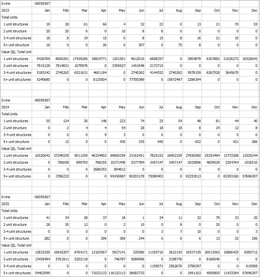 07.16.26. GeoSpatial Analytics: Examining Geographies & Subject Matter .. goto top
Mapping & GeoSpatial Analysis; GeoDemographic Analytics
Every Thursday -- 03:00 PM Eastern Time (US and Canada) Meeting link: https://us06web.zoom.us/j/87297163440?pwd=3FXqJWdWiUivakYDT1kMggGxbsBabj.1 Meeting ID: 872 9716 3440 .. Passcode: 143290 .. above link & ID the same on Thursdays through December 2026
Navigating the Website & Accessing Resources
.. home page .. http://proximityone.com .. SiteMap .. bottom of every page .. Calendar .. via SiteMap or home page .. using Calendar & searching for topics/events .. https://proximityone.com/calendar.htm Host ... Warren Glimpse ProximityOne -- http://proximityone.com .. we build and apply decision-making information and develop related tools empowering you wglimpse@proximityone.com About this Session Who this session is for and how you benefit .. strategists needing to understand use of geospatial methods in collaborative settings .. analysts and researchers .. librarians and information specialists .. learners & researchers use of GIS & geospatial tools and methods This session is designed for a 30 minute presentation and up to 30 minute discussion. .. the Topics section provides session structure but many items have only passing reference. .. details vary by week. Topics This session includes the topics listed below. .. this is not a slide show. Ask questions as we go. .. ~30 minute presentation followed by discussion. Topics Today • 2025-26 Monthly New Authorized Residential Construction .. 02/20/26 Nov & Dec 2025 Building Permits Released .. 03/19/26 Jan 2026 data .. 05/05/26 Feb & Mar 2026 data .. 05/14/26 2025 annual data .. 05/24/26 Apr 2026 data .. 06/25/26 May 2026 data .. 3-year monthly example of building permits for Irvine, CA • Federal Statistical data access & use .. update .. https://proximityone.com/fss/index.html • Visual Data Analytics Web GIS menu Recent releases • 04/27/26 -- Census -- CB Smoothed TIGER Vintage 2024 -- release • 04/29/26 -- Congressional Communities -- DA2+ narrative profile see example • 05/05/26 -- Census -- Feb & Mar 2026 Building Permits Released • 05/07/26 -- Census/Education -- 2024 School System Sources & Uses of Funds -- SDFA23 • 05/14/26 -- Census -- 2025 Annual Building Permits Released • 05/14/26 -- Census -- Vintage 2025 City and town (incorporated place and minor civil division) population • 05/14/26 -- Census -- Vintage 2025 National, State, and County housing units • 05/14/26 -- BLS -- Virtual Data Users Conference -- Insights on the U.S. Housing Market & Regional Tremds • 05/28/26 -- Census -- Apr 2026 Building Permits Released • 06/02/26 -- BLS -- QCEW 25Q4 -- https://www.bls.gov/cew/ -- using DEDE • 06/03/26 -- BLS -- April Metropolitan Area Employment and Unemployment (Monthly) • 06/25/26 -- Census -- May 2026 Building Permits Released • 06/25/26 -- Census -- Vintage 2025 County population by age, sex, race, and Hispanic origin • 06/25/26 -- BEA -- GDP (3rd Est), Industries, Corporate Profits, State GDP, and State Personal Income, 25Q1 • 06/25/26** -- NCES -- SYFY 2023 Common Core of Data School-Level Finance Survey (SLFS) • 07/01/26** -- BLS -- May Metropolitan Area Employment and Unemployment (Monthly) • 07/02/26 -- BLS -- June 2026 Employment Situation • 07/12/26* -- Census -- 2024 Annual County Business Patterns; County, ZIP, Congressional District • 07/14/26 -- BLS -- June 2026 Consumer Price Index • 07/15/26 -- ProximityOne -- Situation & Outlook Estimates & Projections -- 7-15-26 release • 07/15/26 -- ProximityOne -- Congressional Communities Quarterly Estimates & Projections -- 7-15-26 release .. first time available now 2020Q1 through 2026Q2 estimates; 2026Q3 through 2028Q4 projections; and annual .. based on tract level estimates & projections same period controlled to CC120 configurations .. controlled to CD level; each period • 07/24/26 -- Census -- June 2026 Building Permits Released • 07/29/26** -- BLS -- June Metropolitan Area Employment and Unemployment (Monthly) • 08/07/26 -- BLS -- July 2026 Employment Situation • 08/12/26 -- BLS -- July 2026 Consumer Price Index • 08/15/26 -- Census -- July 2026 Address Count Listing Files by Block • 08/25/26 -- Census -- July 2026 Building Permits Released • 08/28/26 -- BLS -- QCEW 26Q1 -- https://www.bls.gov/cew/ -- using DEDE • 09/02/26** -- BLS -- July Metropolitan Area Employment and Unemployment (Monthly) • 09/04/26 -- BLS -- August 2026 Employment Situation • 09/11/26 -- BLS -- August 2026 Consumer Price Index • 09/15/26* -- Census -- ACS 2025 1-year -- using DEDE • 09/24/26 -- Census -- August 2026 Building Permits Released • 09/25/26* -- TIGER 2026 ("TL") digital map database available. • 09/30/26** -- BLS -- August Metropolitan Area Employment and Unemployment (Monthly) • 09/30/26 -- BEA -- GDP (3rd Est), Ind, Corp Profits, St GDP & St Personal Income, 26Q2; St PCE prior year • 10/02/26 -- BLS -- September 2026 Employment Situation • 10/14/26 -- BLS -- September 2026 Consumer Price Index • 10/15/26 -- ProximityOne -- Congressional Communities Quarterly Estimates & Projections -- 10-15-26 release .. 2020Q1 through 2026Q3 estimates; 2026Q4 through 2028Q4 projections; and annual .. based on tract level estimates & projections same period controlled to CC120 configurations .. controlled to CD level; each period • 10/27/26 -- Census -- September 2026 Building Permits Released • 10/28/26** -- BLS -- September Metropolitan Area Employment and Unemployment (Monthly) * estimated date ** release added Calendar Week at a Glance Vintage 2025 County Age, Race/Origin, Gender Data • released by Census today 6/25/26 • concludes release of Vintage 2025 series • Vintage 2026 starts in December with 2026 state estimates 120th Congress Congressional Districts • 120th Congressional Districts .. about • Redistricting Urban Areas VDA GIS Using Multiple Topographic Layers • Using the CityTrends Project Comparing VDAW4 and iVDA Using GIS & Scope of Resources Summary of Data -- dynamic updates - Situation & Outlook Project .. estimates & projections .. usage - Base Project .. usage - Housing Study Projects .. usage - Manhattan, KS - Clark County (Las Vegas) School District Project .. usage - Census 2020 Blocks Project .. usage - ZIP Code - Census Tract Project .. usage - Hispanic Population by Specific Origin Project .. usage -- among many others .. compare - TIGER shapefiles -- usage -- U.S. national scope multi-area direct add shapefiles -- geocoding and address-matching - metadata -- variables/names used in layers 1. Census 2020 Demographic Profile items -- 160 items -- xls file 2. ACS 20xx Demographic Profile items -- itemset1 selected D,S,E,H items -- file 3. Population Model Based Estimates -- CBSA file 4. Ad hoc DEDE Selected ACS items 5. BEA Regional Economic Information System (REIS) 6. BLS Quarterly Census of Employment and Wages 7. Federal Deposit Insurance Corporation Summary of Deposits 8. NCES CCD School District Expenditures 9. NCES CCD Fiscal School .. DBF file 10. NCES CCD NonFiscal School District - Demographic-Economic Data Explorer (DEDE) Software CV XE GIS Desktop -- requires Windows installation .. usage - used to develop and maintain all projects (above) Visual Data Analytics Desktop .. requires Windows installation .. usage - most powerful, capable and secure - drill-down options Visual Data Analytics Desktop .. remote access .. usage - enables Macs to use VDAD Visual Data Analytics Web 3 -- Web version; nothing to install; phone, tablet, any browser .. usage - some legacy operations only found here - login and time interface; default 10 minutes Visual Data Analytics Web 4 -- Web version; nothing to install; phone, tablet, any browser .. usage - some newer features only found here; going forward iVDA - Visual Data Analytics (VDAW4) implemented via any Web page .. usage - VDA Discovery .. a multi-sourced view using iVDA. VDA tools and databases are developed and maintained by Warren Glimpse/ProximityOne/Alexandria, VA USA and Takashi Hamilton/Tsukasa/Osaka, Japan. 07.16.26. Congressional Communities Working Session .. goto top
Every Thursday -- 04:00 PM Eastern Time (US and Canada)
Meeting link: https://us06web.zoom.us/j/84714451572?pwd=pqqITfroX5PoDsdIc84PgFsrLJzeBi.1 Meeting ID: 847 1445 1572 .. Passcode: 827942 .. above link & ID the same on Thursdays through December 2026 Open to the public Additional Information ProximityOne develops geodemographic-economic data and analytical tools and helps organizations knit together and use diverse data in a decision-making and analytical framework. We develop custom demographic/economic estimates and projections, develop geographic and geocoded address files, and assist with impact and geospatial analyses. Wide-ranging organizations use our tools (software, data, methodologies) to analyze their own data integrated with other data. Contact us (888-364-7656) with questions about data covered in this section or to discuss custom estimates, projections or analyses for your areas of interest. |
|
|