
|
|
|
.. did you know .. based on ACS data, the U.S. population ages 65 years and over increased by 43-percent from 2010 to 2022? See this and related measures in the table below. Click graphic for larger view. 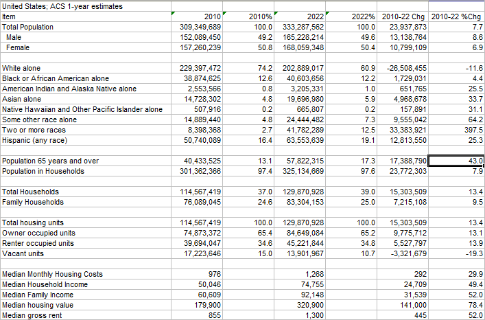 These annual data were developed using the DEDE2 tool. Create data extracts like these for geographic areas down to the Census block group level. Choose from thousands of subject matter items. Use the DEDE2 tool to easily create a demographic time-series view/dataset for a geographic area, 2010 to 2022 annually, based on American Community Survey (ACS) data. Little learning or preparation. Select your own subject matter from any of the detailed subject matter summary files. DEDE2 uses API methods that are both fast and require little source data disk space on your computer. Topics 01 About DEDE2 02 An Illustrative Basic View 03 Installation & Use 04 Operation 05 Output and Usage 06 Creating a GeoList File 07 Special Usage Notes 08 Terms of Use 09 Examples 01 About DEDE2 .. goto top The DEDE2 tool features specialized capabilities related to companion Demographic Economic Data Explorer (DEDE). DEDE2 is focused on using ACS data. Use DEDE2 to easily create: • "geographic composite" files • time series data files 02 An Illustrative Basic View .. goto top The following view illustrates use of the "Run GeoList File" button that starts DEDE2 and generates the data view shown in the grid. Each row in the grid is based on the "GeoList File" file specified below the "Run GeoList File" button. In this example there 23 rows in the file "geo_irvinesd.txt" (Irvine School District, CA). In this case, each row corresponds to a year, ranging from 2010 through 2022. It is easy to see that the total population has changed from 189,219 (2010) to 279.828 (2022) based on ACS 1-year estimates. Optionally click on the "Create XLS" buton to save the grid content as an XLS file. 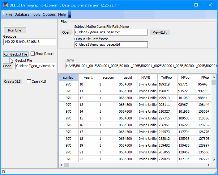 The "Run GeoList File" operation uses the Subject Matter Items File. This example, and the default/start-up file is "C:\dede2\items_acs_base.txt". Samples of this file are included with the installer. This file determines the subject matter items retrieved and displayed in the grid. The first 4 columns in the grid are: Sumlev .. geographic summary level Year1 .. ACS program year ACSPGM .. 1 for ACS one year estimates, 5 for ACS 5 year estimates GEOID .. geocode for area 03 Installation & Use .. goto top To install DEDE2 on any Windows computer, run the installer. Register for more installer and usage information. See terms of use. 04 Operation .. goto top Quickstart 1 .. Click the Run One button to view attributes for one selected geographic area. A message is displayed showing attributes specified in the Items edit box - for the summary level, year, ACS 1/5 and geography specified in the Geocode edit box. Examples: 040-05-1-48 results in 2005 estimates for Texas (48) 040-22-1-48 results in 2022 estimates for Texas (48) Using Ctri-C will copy the content of the message to clipboard. Quickstart 2 .. Click the Run GeoList File button to view attributes/create a file for: - Geolist file specified in GeoList File edit box - in combination with the Subject Matter Items File. GeoList File The GeoList File edit box below the Run GeoList button the geographic area selection. Easily switch specifications with a keystoke or two. no spaces in Geoccde string default: 140-19-5-04013216813 structure: SUM-YR-T-GEOCODE SUM .. summary level YR .. ACS year: 10 to 22 annually (any one year per run) T .. type .. 1 for one year estimates, 5 for 5 year estimates GEOCODE structured as required for summary level GeoList Files Included with Installer • geo_us.txt .. U.S. geography time series file one line for each year; specifies 1 year estimates. • geo_irvinesd.txt .. Irvine, CA school district time series file one line for each year; specifies 1 year estimates. • geo_lagunacomposite.txt .. Laguna Beach, CA composite file one line for each area; specifies 5 year estimates. • geo_lagunacity.txt .. laguna Beach, CA time series file one line for each year; specifies 5 year estimates. • geo_lagunatract.txt.. laguna Beach, CA selected tract time series file one line for each year; specifies 5 year estimates. Scope of Summary Levels Supported & Examples Working Geocode Strings
010: United States (geoid not used)
010-22-5- 040: State (SS) 040-22-5-06 050: County (SSCCC) 050-22-5-06059 140: Census Tract (SSCCCTTTTTT) Census 2020 code used 2021 forward; Census 2010 code used 2010 through 2020 140-22-5-06059062605 150: Block group (SSCCCTTTTTTB) Census 2020 code used 2021 forward; Census 2010 code used 2010 through 2020 150-22-5-060590626051 160: City/Place group (SSPPPPP) geocodes and boundaries update annually; most do not change 160-22-5-0639178 300: CBSA, MSA/MISA (MMMMM) .. 2020 version only available for ACS2022 300-22-5-31080 400: Urban Area (UUUUU) Census 2020 code used 2021 forward; Census 2010 code used 2010 through 2020 Definition different for Census 2010 and 2020 400-22-5-51445 500: 118th Congressional District (SSCC) CD Sessions differ across ACS program years 500-22-5-0647 610: 2022 State Legislative District - Upper (SSDDD) .. only available for ACS2022 610-22-5-06036 620: 2022 State Legislative District - Lower (SSDDD) .. only available for ACS2022 620-22-5-06072 860: ZIP Code area (ZZZZZ) Census 2020 code used 2021 forward; Census 2010 code used 2010 through 2020 860-22-5-92651 970: School District Unified (SSDDDDD) geocodes and boundaries update annually; most do not change 970-22-5-0620370 Subject Matter Item Files Subject Matter Item Files (SMIF) control what subject matter items are extracted to the grid. SMIFs are text files that include a row for each item extracted. SMIF lines include the ACS item code, a shortname for the item and a description of the item. Several SMIFs are included with the installer. You can create your own. The number of items limit is 50 in one run. Ready to use SMIFs include: • items_acs_base.txt • items_acs_age49.txt • items_acs_movers_b07204.txt The set of 25 items included in the "items_acs_base.txt" default Subject Matter Items File are shown below. .. use leftmost 11 characters for item codes.
NAME NAME NAME
B01001_001E TotPop Total Population B01001_002E MPop Male B01001_026E FPop Female B02001_002E White1 White alone B02001_003E Black1 Black or African American alone B02001_004E AIAN1 American Indian and Alaska Native alone B02001_005E Asian1 Asian alone B02001_006E NHOPI1 Native Hawaiian and Other Pacific Islander alone B02001_007E Other1 Some other race alone B02001_008E Multi Two or more races B03002_012E Hisp Hispanic (any race) B09020_001E Pop65up Population 65 years and over B11002_001E PopHH Population in Households B11001_001E HH Total Households B11001_002E Fam Family Households B25003_001E TotHsg Total housing units B25003_002E OwnOcc Owner occupied units B25003_003E RntOcc Renter occupied units B25002_003E Vacant Vacant units B25105_001E MDMTHHC Median Monthly Housing Costs (Dollars) B19013_001E MHI Median Household Income B19113_001E MFI Median Family Income B25077_001E MHV Median housing value B25064_001E MdRent Median gross rent 05 Output and Usage .. goto top When DEDE2 is started, the SMIF subject matter is retrieved for each record in the Geocode File. The results are displayed in the grid. A row is displayed in the grid for each Geocode File record retrieved. If not Geocode File record can be retrieved, no record is written to the grid. The grid output may be optionally saved as an XLS file. 06 Creating a GeoList File .. goto top The following lines comprise the geo_lagunacity.txt geolist file included with the installer. .. the summary level is set at 160 -- city/place .. there are 23 lines corresponding to data years 2010 through 2022. .. as this is a city under 65,000 population, the ACS 5 year program is selected. .. the city geocode is 0638178.
160-10-5-0639178
160-11-5-0639178 160-12-5-0639178 160-13-5-0639178 160-14-5-0639178 160-15-5-0639178 160-16-5-0639178 160-17-5-0639178 160-18-5-0639178 160-19-5-0639178 160-20-5-0639178 160-21-5-0639178 160-22-5-0639178 To modify this file and save it as Fresno city, CA, change the "5-0639178" to "1-0627000" and save the file as fresnocity.txt. Get the Fresno place code here: https://proximityone.com/cities.htm#table
160-10-1-0627000
160-11-1-0627000 160-12-1-0627000 160-13-1-0627000 160-14-1-0627000 160-15-1-0627000 160-16-1-0627000 160-17-1-0627000 160-18-1-0627000 160-19-1-0627000 160-20-1-0627000 160-21-1-0627000 160-22-1-0627000 07 Special Usage Notes .. goto top These data are statistical survey estimates based on the Census Bureau American Community Survey (ACS) program. The estimates are subject errors of estimation and other errors. ACS data are available as "1-year" and "5-year" periods. These data are released annually. The 2022 ACS 1-year data were released in September 2023; The 2022 ACS 5-year data were released in December 2023. Time series data based on ACS data can be inherently challenging due to changes made from year-to-year in the geography (geocodes and/or geographic area) for which data are tabulated/published and the definition/item name for the subject matter tabulated. The ACS "1-year" data are estimates corresponding to one year; for example ACS 2022 1-year estimates are data based on survey respondents for calendar year 2022. The ACS "5-year" data are estimates corresponding to a 5-year period; for example ACS 2022 5-year estimates are data based on survey respondents for the calendar years 2018 through 2022. In this example, these are not data for 2022, but rather the period 2018 through 2022. They can also be thought of as estimates centric to 2020. The 2020 ACS 1-year estimates are not available because of the impact of the COVID-19 pandemic on data collection. If data are not available for a specific API call, no data are written to the grid. Reasons include: .. an 2020 ACS 1 year estimate is referenced in the call (data not tabulated). .. the geocode referenced has changed and not available in the call. Congressional District geolist files Using the cd0647.txt geolist file results in the data retrieved as shown below. .. these data are for CD 47 in Orange County, CA. .. note the congressional district vintage differs over time even though the CD geocode might exist. .. the geographic boundary for CDs may vary and the data noncomparable from year to year. .. in this application, the data for 2021 CD 0647 (116th Congress) total population of 701,834 is not comparable to the data for 2022 CD 0647 (118th Congress) total population of 752,940. 500 10 1 0647 Congressional District 47 (111th Congress), California 634506 500 11 1 0647 Congressional District 47 (112th Congress), California 637759 500 12 1 0647 Congressional District 47 (113th Congress), California 722624 500 13 1 0647 Congressional District 47 (113th Congress), California 721957 500 14 1 0647 Congressional District 47 (114th Congress), California 718747 500 15 1 0647 Congressional District 47 (114th Congress), California 718339 500 16 1 0647 Congressional District 47 (115th Congress), California 714311 500 17 1 0647 Congressional District 47 (115th Congress), California 723526 500 18 1 0647 Congressional District 47 (116th Congress), California 710853 500 19 1 0647 Congressional District 47 (116th Congress), California 717594 500 21 1 0647 Congressional District 47 (116th Congress), California 701834 500 22 1 0647 Congressional District 47 (118th Congress), California 752940 08 Terms of Use .. goto top There is no warranty for any aspect of using the DEDE tools or data. The user is responsible for any use. Data output from using DEDE may be used without restriction. 09 Application Examples .. goto top School District Time Series This example illustrates use of DEDE2 to develop time series demographic profiles/datasets for Rutherford County School District, TN (Federal code 4703690) and Murfreesboro City Elementary School District, TN (Federal code 4703150) annually for 2010 through 2022 based on the American Community Survey (ACS) 5-year estimates. Note that these years are the ACS program years. See this related interactive table to examine these and all school districts. Two graphics and links to related excel file are shown below. These data are the DEDE2 output generated when using the subject matter items file, displayed as a graphic below the two district profiles. Each district profile shows a row for each year, 2010 through 2022. Codes and area names are shown at the left with the demographic data values shown in the rightmost columns. The headers provide abbreviated names that are further described in the subject matter items file below. Rutherford County School District, TN The following graphic illustrates that the total population for the County school district changed from 147,702 to 190,215 over the period. The DEDE2 user can use any set of subject matter items from the ACS summary file; for example the school age population, enrollment, educational attainment, etc. 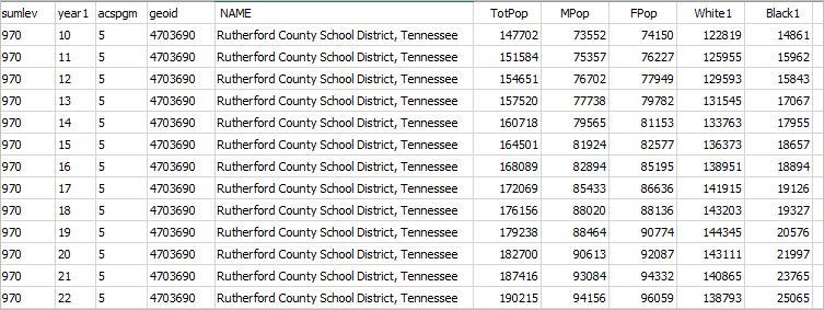
click to access all columns Excel file Murfreesboro City Elementary School District, TN The following graphic illustrates that the total population for the City school district changed from 102,815 to 153,512 over the period. In this case, the City school district in geographically contained within the County school district. 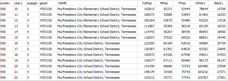
click to access all columns Excel file Subject Matter Items File .. used for above DEDE2 runs 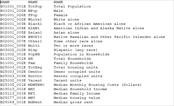
Mapping & Geospatial Analysis of the School Districts The following graphic shows a lay-of-the-land view of the two school districts. Use the Open VDA Web GIS resource (more about to create this view or other similar views. This view shows K-12 schools as markers. Click here to start Open VDA Web GIS .. nothing to install, no registration, no fee. .. see the related Examining a School District tutorial for step-by-step instructions. .. note that DEDE2 and VDA Web GIS are separate, but related, applications. 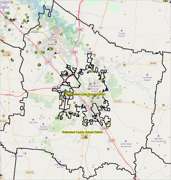
End of this application example .. goto top ProximityOne User Group Join the ProximityOne User Group to keep up-to-date with new developments relating to metros and component geography decision-making information resources. Receive updates and access to tools and resources available only to members. Use this form to join the User Group. Support Using these Resources Learn more about accessing and using demographic-economic data and related analytical tools. Join us in a Data Analytics Lab session. There is no fee for these one-hour Web sessions. Each informal session is focused on a specific topic. The open structure also provides for Q&A and discussion of application issues of interest to participants. Additional Information ProximityOne develops geographic-demographic-economic data and analytical tools and helps organizations knit together and use diverse data in a decision-making and analytical framework. We develop custom demographic/economic estimates and projections, develop geographic and geocoded address files, and assist with impact and geospatial analyses. Wide-ranging organizations use our tools (software, data, methodologies) to analyze their own data integrated with other data. Follow ProximityOne on Twitter at www.twitter.com/proximityone. Contact ProximityOne (888-364-7656) with questions about data covered in this section or to discuss custom estimates, projections or analyses for your areas of interest. |
|
|