
|
|
|
-- annually updated demographic-economic data to the block group level December 2023 .. did you know? .. Palo Alto Unified School District, CA had the highest 2022 percent bachelor's degree or higher educational attainment among all school districts with 65,000 population and over (1,076 districts)? Use the interactive table below to view, sort, query ACS 2022 1-year estimates for each geographic area 65,000 population or more for most types of geographies published in the ACS 2022 1-year program. Usage example, benefits: get view/examine characteristics of largest 10 (some number) of largest areas by type, such as school districts, city, metros ... About the American Community Survey 2022 Essential data to assess where we are, how things have changed and how things might change in the future down to the sub-neighborhood level. The American Community Survey (ACS) is a nationwide survey designed to provide annually updated demographic-economic data for national and sub-national geography. ACS provides a wide range of important data about people and housing for every community across the nation. The results are used by everyone from planners to retailers to homebuilders and issue stakeholders like you. ACS is a primary source of local data for most of the 40 topics it covers, such as income, education, occupation, language and housing. ProximityOne uses ACS data to develop current estimates on these topics and 5-year projections. ACS 2022 1-Year Data Mapping & Geospatial Analysis Which school districts are included in the ACS 2022 1-year tabulation? The following Texas zoom-in view shows school districts (blue fill pattern) included in the ACS 2022 1-year tabulation. Click graphic for larger view showing school district codes. Expand to full window for best view. The expanded view shows school district codes (use in table below). The ACS 2022 1-Year GIS Project is available for downloading for use with CV XE GIS or VDAGIS tools via the Mapping Statistical Data section. Or, use the GIS project via the VDA Desktop GIS, with only a browser, via the VDA Remote Desktop service (VDADRD) 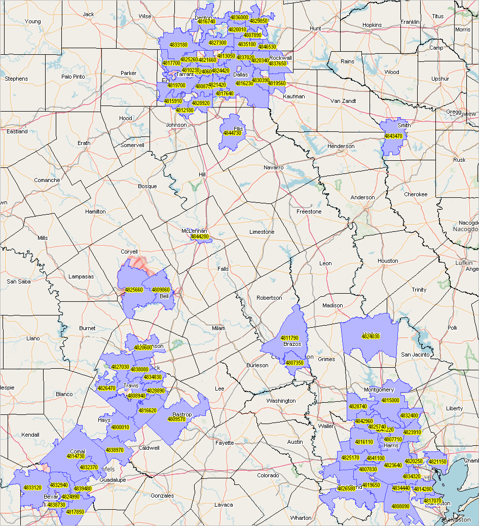
About this Section ... goto top This section is focused on ACS 2022 data access, integration and use. It is frequently updated. Register to receive updates. Recent & Ahead • ACS 2022 5-year data released 12/07/23. • Extract these data to Excel & GIS friendly datasets using DEDE (12/15/23). • Map, view, geospatially analyze these data using VDAGIS tools (12/15/23). • What's ahead with the American Community Survey 2024 .. conducted calendar year 2024. Accessing & Using ACS 2022 Data ... goto top • Demographic-Economic Data Explorer • VDA Web GIS • Data Profiles - General Demographics 91 items - Social Characteristics 154 items - Economic Characteristics 137 items - Housing Characteristics 143 items ACS 2022 1-Year Selected Tabulation Areas .. 2022 Demographics .. goto top Use the buttons & tools below the table for most effective use of this table and data. Table sorted by summary level (type of geography, col 5) by name. except regions and divisions located at bottom of table. Regions (sumlev 020) are iterated by metro/nonmetro. Click ShowAll button between Find/Queries. Use mouseover on column header to view column description. See usage notes below table. Custom Geo Set 1 defaults to 5 Houston Area school districts. Custom Geo Set 2 defaults to 5 Los Angeles metro congressional districts. Note that in Custom GeoSet 2 you can enter geocodes for other types of mixed summary levels. .. try 00000 06000 48000 06059 48201 Clicking either button displays data for only the selected areas. Try your own! Get codes (65,000 pop and over): County .. City .. School District .. CBSA/Metro .. Congressional District .. Urban Area .. PUMA Usage Notes • If table not showing any rows; click ShowAll button below table. • Use vertical and horizontal scroll bars to navigate up/down or left/right. • Adjust column widths using column divider between header cells. Example See that there are 17 Missouri counties included in the table by: Click ShowAll button Select Missouri in State dropdown Select 050 County in the SumLev dropdown .. the table refreshes with these geographic areas Click the Popolation column header to see that St. Louis County has the largest 2022 population. Click the Population column header again to see that St. Fancois County has the smallest 2022 population. .. among Missouri counties 65,000 population or more. Scope of Geography Table includes all of the areas 65,000 population and over for the types of geography listed below. Using the table, select a specific type of geography using the "SumLev" dropdown. - 010 U.S. - 020 Regions (all) - 030 Divisions (all) - 040 States (all) - 050 Counties - 060 County Subdivisions - 160 Cities - 300 Core-Based Statistical Areas (CBSAs - all) - 314 Metropolitan Divisions - 330 Combined Statisitcal Areas - 400 Urban Areas - 500 Congressional Districts (all) - 795 Public Use Microdata Areas (PUMAs - all) - 900 School Districts Items in Table - Incumbent - St - GeoID - GeoID1 - Summary Level - Population - Median Age - Median Household Income - Housing Units - Households - Vacant Units - Median Housing Value - Median Rent - High school graduate or higher (%) - Bachelor's degree or higher (%) - Population 25 years and over - Less than 9th grade - 9th to 12th grade, no diploma - High school graduate (includes equivalency) - Some college, no degree - Associates degree - Bachelors degree - Graduate or Prof degree ACS 2022 Areas Published ... goto top • See below ACS 2022 Data Resources ... goto top • 2022 ACS 1-year estimates .. September 14, 2023 .. estimates for areas 65,000 population and over • 2022 ACS 1-year supplemental estimates .. October 9, 2023 .. estimates for areas 65,000 population and over • 2022 ACS 5-year estimates "ACS 2018-2022 5-year period" .. December 7, 2023 .. estimates for all areas down to block group level • 2022 ACS 1-year PUMS data .. October 19, 2023 .. microdata data for custom estimates and individual modeling • 2022 ACS 5-year PUMS data "ACS 2018-2022 5-year period" .. January 25, 2024 .. microdata data for custom estimates and individual modeling Using ACS Data; ACS 1-Year versus ACS 5-Year Data .. top While ACS 1-year estimates are suitable for time-series analyses, the ACS 5-year estimates are not the same as annual demographic-economic estimates and may not be suitable for annual time series analyses. Advantages of using the 5-year estimates • the data are available for all census tracts and ZIP code areas. • the data are available for all cities/places, counties and school districts irrespective of size. Disadvantages of using the 5-year estimates • the data are older than the 1-year estimates. • the data are for a 5-year period rather than one year. • additional cautions in comparing estimates over time (see below). Advantages of using the 1-year estimates • the data are more recent than the 5-year estimates. • the data are generally more accurate than the 5-year estimates. Disadvantages of using the 1-year estimates • the data are not available for block groups, census tracts and ZIP code areas. • the data are available for only areas of 65,000 population and over. Additional cautions in comparing estimates over time • ACS 2012 5 year estimates are based on survey respondent data for the years 2008 through 2012. • ACS 2013 5 year estimates are based on survey respondent data for the years 2009 through 2013. • ACS 2014 5 year estimates are based on survey respondent data for the years 2010 through 2014. • ACS 2015 5 year estimates are based on survey respondent data for the years 2011 through 2015. • ACS 2016 5 year estimates are based on survey respondent data for the years 2012 through 2016. • ACS 2017 5 year estimates are based on survey respondent data for the years 2013 through 2017. • ACS 2018 5 year estimates are based on survey respondent data for the years 2014 through 2018. • ACS 2019 5 year estimates are based on survey respondent data for the years 2015 through 2019. • ACS 2020 5 year estimates are based on survey respondent data for the years 2016 through 2020. • ACS 2021 5 year estimates are based on survey respondent data for the years 2017 through 2021. • ACS 2022 5 year estimates are based on survey respondent data for the years 2018 through 2022. • The ACS 2012 5 year data & ACS 2013 5 year data are based on the same respondent data for the four years 2009 through 2012. • The ACS 2013 5 year estimates drop 2008 respondents and add 2013 respondents. • The ACS 2014 5 year estimates drop 2009 respondents and add 2014 respondents. • The ACS 2015 5 year estimates drop 2010 respondents and add 2015 respondents. • The ACS 2016 5 year estimates drop 2011 respondents and add 2016 respondents. • The ACS 2017 5 year estimates drop 2012 respondents and add 2017 respondents. • The ACS 2018 5 year estimates drop 2013 respondents and add 2018 respondents. • The ACS 2019 5 year estimates drop 2014 respondents and add 2019 respondents. • The ACS 2020 5 year estimates drop 2015 respondents and add 2020 respondents. • The ACS 2021 5 year estimates drop 2016 respondents and add 2021 respondents. • The ACS 2022 5 year estimates drop 2017 respondents and add 2022 respondents. Other considerations • Are the needed subject matter available from Census 2010/20? - ACS more detailed demographic-economic data (like income) may not be a plus. • Census 2010/20 provides more accurate data than ACS estimates. • Often there are more detailed age (and other) breakouts for subject matter in Census 2010/20 compared to ACS. • The most recent ACS-sourced small area data are from ACS 2021 (December 2022) 5-year estimates; - ACS 2021 5-year estimates are centric to 2019. Areas Published ... goto top ... availability of summary statistic data by type of geography ... link in left column provide access to related interactive tables for specific geographic level.
Notes ... 1 County equivalents include Alaska boroughs, municipalities, city and boroughs, and census areas; the District of Columbia; Louisiana parishes; Puerto Rico municipios; independent cities in Maryland, Missouri, Nevada, and Virginia. 2 For 1-year estimates, qualifying Minor Civil Divisions in 20 states only. For 5-year estimates, all county subdivisions. 3 1-year estimates are not produced for this geographic level, regardless of population size. 4 All metropolitan statistical areas receive ACS 1-year estimates. A population minimum of 50,000 is applied instead of the standard 65,000. 5 Legislative session year 2022. 6 In operation as of January 1, 2022. * Counts based on geographic area boundaries as of January 1, 2021. ** ACS data are not published for blocks. About the American Community Survey 2024 ... goto top The American Community Survey 2024 will be conducted during calendar year 2024. Data from this statistical survey will be available in the fall 2025. The number of ACS respondents is generally 3,576,000 for household respondents; 20,100 for contacts in group quarters; 170,900 people in group quarters; 22,875 households for reinterview; and 1,422 group quarters contacts for reinterview. The total estimated number of respondents is 3,791,297. The average hours per response is 40 minutes for the average household questionnaire; 15 minutes for a group quarters facility questionnaire; 25 minutes for a group quarters person questionnaire; 10 minutes for a household reinterview; 10 minutes for a group quarters-level reinterview. The estimated respondent burden hours is 2,384,000 for household respondents; 5,025 for contacts in group quarters; 71,208 for group quarters residents; 3,813 households for reinterview; and 237 group quarters contacts for reinterview. The estimate is an annual average of 2,464,283 burden hours. ACS needs and uses ... The U.S. Census Bureau requests authorization from the OMB for revisions to the American Community Survey (ACS). The ACS is one of the Department of Commerce's most valuable data products, used extensively by businesses, nongovernmental organizations (NGOs), local governments, and many federal agencies. In conducting this survey, the Census Bureau's top priority is respecting the time and privacy of the people providing information while preserving its value to the public. In 2024, the ACS plans to add internet self-response as an additional option to the group quarters data collection operation. The Census Bureau believes there is value in offering a self-response option to people living in certain types of group quarters�college/university student housing, group homes, military barracks, workers' group living quarters and Job Corps centers, and emergency and transitional shelters. The group quarters data collection operation will continue to offer paper, telephone, and in-person response options to collect data. The Census Bureau is authorized by law (Title 13, U.S. Code) to use existing information that has already been collected by other government agencies, whenever possible and consistent with the kind, timeliness, quality, and scope of the statistics required, instead of asking for such information directly from the public. The Census Bureau is allowed to use these data for statistical purposes only and may not use these records for enforcement purposes or to decide on eligibility for a benefit. Additionally, Census Bureau research has shown that using administrative data can reduce respondent burden and improve the quality of the ACS data. In 2024, the Census Bureau will supplement or replace ACS survey data for the question asking about property acreage. The Census Bureau will continue research to explore how administrative data can be used for other items on the survey, with initial efforts focusing on other housing items, such as agricultural sales and year built. In addition to using administrative records and in coordination with the Office of Management and Budget Interagency Committee for the ACS, the Census Bureau solicited proposals for question changes or additions from more than 20 federal agencies. Approved topics underwent cognitive testing to verify that proposed question wording would be understood by respondents. Based on cognitive testing results, the Census Bureau proposes to update wording in 2024 for questions on three topics: condominium fees, home heating fuel, and journey to work. The Census Bureau proposes to implement these three topics without additional testing; other topics are still undergoing testing. The condominium fees question would be extended to include homeowners association (HOA) fees. Data sources continue to show housing units that are part of HOAs outnumber housing units in condominiums. In order to provide more comprehensive and accurate costs of owning a home, the ACS needs to capture HOA fees for these homes. Adding these fees to the existing condominium fees question avoids adding a new question to the ACS and therefore minimizes respondent burden. The change to the home heating fuel question would update the natural gas and bottled gas categories. This will aid respondents in identifying the correct category more easily by using more commonly used terminology. In Puerto Rico, the question wording also changed to indicate respondents should only include fuel that heats their home. The journey to work question would be updated to include ride-sharing services as a mode of transportation to work to account for new and growing travel trends. This will reduce ambiguity in the current question about where respondents should report ride-sharing commutes and will allow the government to monitor changes in transportation patterns for planning purposes. ProximityOne User Group ... goto top Join the ProximityOne User Group to keep up-to-date with new developments relating to metros and component geography decision-making information resources. Receive updates and access to tools and resources available only to members. Use this form to join the User Group. Support Using these Resources Learn more about accessing and using demographic-economic data and related analytical tools. Join us in a Data Analytics Lab session. There is no fee for these one-hour Web sessions. Each informal session is focused on a specific topic. The open structure also provides for Q&A and discussion of application issues of interest to participants. Additional Information ProximityOne develops geodemographic-economic data and analytical tools and helps organizations knit together and use diverse data in a decision-making and analytical framework. We develop custom demographic/economic estimates and projections, develop geographic and geocoded address files, and assist with impact and geospatial analyses. Wide-ranging organizations use our tools (software, data, methodologies) to analyze their own data integrated with other data. Follow ProximityOne on Twitter at www.twitter.com/proximityone. Contact us (888-364-7656) with questions about data covered in this section or to discuss custom estimates, projections or analyses for your areas of interest. | ||||||||||||||||||||||||||||||||||||||||||||||||||||||||||||||||||||||||||||||||||||||||||||||||||||||||||||||||||||||||||||||||||||||||||||||||||||||||||||||||||||||||||||||||||||||||||||||||||||||||||||||||||||||||||||||||||||
|
|