
|
|
|
-- accessing 1-year estimates using API tools -- develop national scale spreadsheet files with virtually no learning time How to acquire a spreadsheet showing the population of all cities with population estimates based on the ACS 2016 1-year data? ... or, housing units, median household income, median housing value, etc.? Variations of this need frequently arise -- what is the list of largest California counties sorted on total population: What are the 25 metros having the highest median household income? Which 10 congressional districts have the highest poverty incidence? Which urban areas have the highest educational attainment? This section is focused on showing how simple API calls can be used to get answers to these types of questions -- and more. Urban Areas with 2016 Population 65,000+ Population ... results from using the API downloaded data ... the following graphic shows urban areas with 65,000 or more 2016 population; zoom-in to Texas. The full national scope GIS project is available as described below; examine U.S. or any region. The file used to develop this view was created using the results of the API call reviewed below (requires integration of those data into the urban areas shapefile). Click graphic for larger view; expand browser window. Larger view shows urban areas labeled with name and mini profile for Dallas UA showing all subject matter items downloaded (via API) as described below. 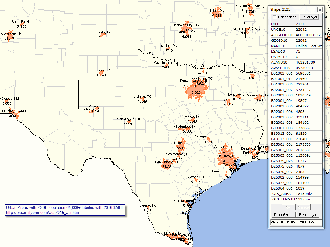 ... View developed using CV XE GIS. Map your own locations with geography of interest. ... See more about Urban Population & Urban Areas. Access ACS 2016 1-Year Data Using API Tools Use these API calls to access/download selected items for selected geographies. See more about using API tools. Click a link and receive a return page with CSV-like structured data. See usage notes below. As these are ACS 2016 1 year estimates; geographies are only available for areas 65,000+ population. Click a link: • All U.S. cities/places • All U.S. counties • All U.S. CBSAs • All U.S. Urban Areas • All 115th Congressional Districts • All U.S. states • U.S. only The following data retrieval operations are by state. These are examples using Arizona (FIPS state code 04). • All [within state] Elementary School Districts • All [within state] Secondary School Districts • All [within state] Unified School Districts API Call Returned Data Usage Notes Clicking the All U.S. cities/places link above generates a new page. The first few records are shown below (scroll section). [["B01003_001E","B01001_011E","B01001_035E","B02001_002E","B02001_003E","B02001_004E","B02001_005E","B02001_006E","B02001_007E","B02001_008E","B03001_003E","B19013_001E","B19113_001E","B25001_001E","B25002_002E","B25003_002E","B25075_025E","B25075_026E","B25075_027E","B25002_003E","B25077_001E","B25064_001E","NAME","state","place"], ["213434","9554","11478","52557","152114","490","1429","0","3462","3382",null,"36241","43062","114371","90117","41404","106","46","26","24254","88500","777","Birmingham city, Alabama","01","07000"], ["67714","2365","2544","41231","23682","201","977","0","729","894",null,"42336","56746","30960","26119","15129","50","18","25","4841","142000","720","Dothan city, Alabama","01","21184"], ["84943","2407","2956","60222","14217","381","5477","69","2493","2084",null,"79004","101950","34976","32110","21807",null,null,null,"2866","278600","1021","Hoover city, Alabama","01","35896"], The above file looks very much like a CSV file. With the "returned data page" open, type CTRL-A then CTRL-C, open a text editor like notepad, and type CTRL-V, pasting the data into the text editor. Save that file with a name such as: c:\temp\acsdata.csv. Perform a global search and replace on the file removing all [ and ] characters. Finally save the file and import it into a new open spreadsheet page. Items Retrieved in the API Calls The sample header record above shows the subject matter item listed at the left in the following set of items. Modify API call and use other subject matter items. See full array of subject matter - xlsx file. .. B01003_001E - Total population Age .. B01001_011E -- Male: 25 to 29 years (illustrating age cohort access) .. B01001_035E -- Female: 25 to 29 years (illustrating age cohort access) Race/Origin .. B02001_002E - White alone .. B02001_003E - Black or African American alone .. B02001_004E - American Indian and Alaska Native alone .. B02001_005E - Asian alone .. B02001_006E - Native Hawaiian and Other Pacific Islander alone .. B02001_007E - Some other race alone .. B02001_008E - Two or more races .. B03001_003E - Hispanic (of any race) Income .. B19013_001E - Median household income ($) .. B19113_001E - Median family income ($) Housing & Households .. B25001_001E - Total housing units .. B25002_002E - Occupied housing units (households) .. B19001_017E -- Households with household income $200,000 or more .. B25003_002E -- Owner Occupied housing units .. B25075_025E --- Housing units value $1,000,000 to $1,499,999 (owner occupied) .. B25075_026E --- Housing units with value $1,500,000 to $1,999,999 (owner occupied) .. B25075_027E --- Housing units with value $2,000,000 or more (owner occupied) .. B25002_003E - Vacant housing units .. B25077_001E - Median housing value ($) - owner occupied units .. B25064_001E - Median gross rent ($) - renter occupied units The rightmost fields/columns in the rows/records contain the area name and geographic codes. ProximityOne User Group Join the ProximityOne User Group to keep up-to-date with new developments relating to metros and component geography decision-making information resources. Receive updates and access to tools and resources available only to members. Use this form to join the User Group. Support Using these Resources Learn more about accessing and using demographic-economic data and related analytical tools. Join us in a Data Analytics Lab session. There is no fee for these one-hour Web sessions. Each informal session is focused on a specific topic. The open structure also provides for Q&A and discussion of application issues of interest to participants. Additional Information ProximityOne develops geodemographic-economic data and analytical tools and helps organizations knit together and use diverse data in a decision-making and analytical framework. We develop custom demographic/economic estimates and projections, develop geographic and geocoded address files, and assist with impact and geospatial analyses. Wide-ranging organizations use our tools (software, data, methodologies) to analyze their own data integrated with other data. Follow ProximityOne on Twitter at www.twitter.com/proximityone. Contact us (888-364-7656) with questions about data covered in this section or to discuss custom estimates, projections or analyses for your areas of interest. |
|
|