
|
|
|
.. annual population projections to 2060 reflecting climate change .. population estimates & projections for U.S., states, metros, counties, tracts .. incorporating results of Census 2020 and the pandemic .. fewer than half (47%) of U.S. households in 2025 were married couples - a significant shift from 50 years earlier, when nearly two-thirds (66%) were. Among married-couple households, the share with their own children declined over the past half-century. In 1975, more than half (54%) of married-couple households included their own children under age 18; by 2025, that share had declined to about 37%. Households -- in 2025, there were 39.7 million one-person households, accounting for 29% of all households, up from 20% in 1975. The portion of householders age 65 and older rose from 1 in 5 in 1975 to over 1 in 4 in 2025. Families -- the percentage of families with their own children under age 18 in the household declined from 54% in 1975 to 39% in 2025. The above data come from the Current Population Survey Annual Social and Economic Supplement (CPS ASEC), years 2025 and 1975. These data tell us nothing about demograpahics and living arrangements at the county level. How will these data and patterns change in the next 50 years at the county level? .. how and where are county demographics changing? How might this change impact you? Many factors affecting county change with different rates of onset and size are reflected in our annual population projections to 2060 for the U.S. by county population by single year of age group. Ways to examine county demographic characteristics, patterns and change: • Use the interactive table below to examine county projections to 2060. • See more about how and why county population is changing. • Examine county migration by origin destination county and region. • Map/visualize demographicchange using Visual Data Analytics GIS .. about .. need help? contact us. Impact of Climate Change The 2060 projections reflect the disproportionate ways and levels that climate change is impacting the population: .. Fertility, mortality and migration impacted due to climate change factors. .. Flooding from sea level rise, increased storm intensity .. Water shortages from droughts .. Wildfires and drier conditions .. Warmer temperatures allowing disease to spread .. Reduced air quality from warmer temperatures .. Increased in energy consumption (air conditioning and otherwise) .. Health related employment and productivity changes Population Percent Change by County 2010-2060 Patterns of county population change 2010-2060 based on ProximityOne projections 2020-2060. 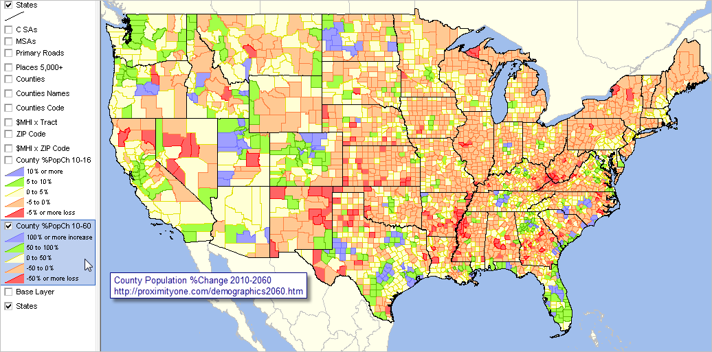 .. view developed with ProximityOne CV XE GIS and related GIS project. .. click graphic for larger view. Demographic Projections by ProximityOne Demographic projections to 2060 are a part of the ProximityOne Situation & Outlook (S&O). These data are used by private and public sector organizations to meet management, research, planning and analytical needs. See how USA TODAY used these data to analyze county level diversity 2060 .. view a county/state diversity profile for any county. Access Options -- illustrations U.S. by county, metro, state, national -- current geography definitions -- annual 2010-60 time series Structured as DBF, CSV or XLSX "Most likely" scenario; other options exist. One time purchase or subscription Total population Total population with components of change with 5-year age cohorts Total population with components of change with 5-year age cohorts by race/origin groups by gender Total housing units Total housing units, occupied units, vacant units Total housing units, occupied units, occupied units: families, vacant units Total housing units, occupied units, occupied units: families, occupied units with families with children under 18 yesrs, vacant units We develop estimates and projections by single year of age; different age breaks, e.g., 5-17, are not a problem. Call for pricing details that best meet your needs -- (888)364-7656. U.S. County Population Trends: 2010-2060 Interactive Table .. gototop The interactive table below provides illustrative data. See terms of use below. .. we develop annual updates with revisions during the year. Usage Notes General navigation: • Use vertical scroll bar at right to scroll across areas. • Use horizontal scroll bar below table to scroll right & view 2010-2060 change. • Click a column header to sort on that column; click column header again to sort in other direction. • Click ShowAll button to show all areas. Filtering & queries: • Click ShowAll button between queries. • Click State (dropdown below table) to select all areas in a selected state. • Key in area name in Find-in-Name edit box then click button to locate all matches (case sensitive). .. searches column 1; default is Harris (for Harris County-Houston TX area); use your own area name of interest. • Key in CBSA/metro code in Find-in-CBSA button then click button to locate all matches (case sensitive). .. optionally get 5-character CBSA code from scroll section (above, right). .. searches CBSA column, default is 26420 (Houston TX metro); use a CBSA code of interest. Column Headers • Type - Type of geography; summary level (see below) • StCty - State + County FIPS Code • CBSA - Core-Based Statistical Area Code • Pop2010 -- 7/1/10 Census Bureau ProximityOne Projections using Model Option 2 • Pop2020 -- 7/1/2020 • Pop2030 -- 7/1/2030 • Pop2040 -- 7/1/2040 • Pop2050 -- 7/1/2050 • Pop2060 -- 7/1/2060 • Ch2010-60 -- population change 2010 to 2060 • %Ch2010-60 -- percent population change 2010 to 2060 Methodology & Vintages go to top Demographic projections presented in this section are developed using an annual time series model. The population in period t (P[t]) for a county is defined/projected using the identity: P[t]:=P[t-1]+B[t]-D[t]+IM[t]+DM[t], where: - P[t] -- resident population as of 7/1/t - P[t-1] -- resident population as of 7/1/t - B[t] -- births during the period 6/30/t-1 to 7/1/t - D[t] -- deaths during the period 6/30/t-1 to 7/1/t - IM[t] -- international migration during the period 6/30/t-1 to 7/1/t - DM[t] -- domestic during the period 6/30/t-1 to 7/1/t • Projections are developed as vintages (released on a certain date). • County projections are developed annually and are updated in March and July .. the July update integrates updated age, race/origin and gender detail .. data presented in the table are extracts showing total population every 10 years .. the underlying dataset includes annual data for many items used in the model • Projections are developed for various scenarios. .. the option 2 scenario uses these assumptions: .. crude birth rate declines over time .. crude death rate increases over time .. migration follows patterns exhibited during the period 2010-2020 .. historical annual data for the period 2010 through 2020 use Census Bureau estimates .. some counties are adjusted for specific circumstances • Different model specifications and vintages will have different projected values. Terms of Use go to top Data provided via this Web page are subject to these terms of use: - they may not distributed except as used in studies or stories. - they are intended for non-business or commercial use. - we request that any usage include reference to ProximityOne and a link to this page: http://proximityone.com/demographics2060.htm - there is no warranty or guarantee of any type for any aspect of these data. - the user of these data is solely responsible for any use of these data. ProximityOne User Group Join the ProximityOne User Group to keep up-to-date with new developments relating to metros and component geography decision-making information resources. Receive updates and access to tools and resources available only to members. Use this form to join the User Group. Support Using these Resources Learn more about accessing and using demographic-economic data and related analytical tools. Join us in a Data Analytics Lab session. There is no fee for these one-hour Web sessions. Each informal session is focused on a specific topic. The open structure also provides for Q&A and discussion of application issues of interest to participants. Additional Information ProximityOne develops geodemographic-economic data and analytical tools and helps organizations knit together and use diverse data in a decision-making and analytical framework. We develop custom demographic/economic estimates and projections, develop geographic and geocoded address files, and assist with impact and geospatial analyses. Wide-ranging organizations use our tools (software, data, methodologies) to analyze their own data integrated with other data. Follow ProximityOne on Twitter at www.twitter.com/proximityone. Contact us (888-364-7656) with questions about data covered in this section or to discuss custom estimates, projections or analyses for your areas of interest. |
|
|