
|
|
|
November 2025 .. important new developments continue to evolve regarding Census 2020 data resources and access to and use of these data. Summary of Main Products 2020 Census Data Products: United States Release date 2020 Census product Selected Geographies 1 Availablility: ✓ = All tables * = Selected tables Nation State County Tract Block group Block Urban/ Rural Place/ MCD ZCTA2 AIANNH3 April 26, 2021 Apportionment • The resident population of the 50 states, plus a count of the U.S. military personnel and federal civilian employees living outside the United States (and their dependents living with them) who can be allocated to a home state. The populations of the District of Columbia and Puerto Rico are not included in the apportionment population because they do not have voting seats in the U.S. House of Representatives. However, the District of Columbia and Puerto Rico are included in the resident population tables. ✓ ✓ August 12, 2021 and September 16, 2021 4 Census (P.L. 94-171) Redistricting Data Summary File • Population counts for race and Hispanic or Latino categories. • Housing unit counts by occupancy status (occupied units, vacant units). • Group quarters population counts by major group quarters type. ✓ ✓ ✓ ✓ ✓ ✓ ✓ Census National Redistricting Data Summary File • Same content as the Census Redistricting Data (P.L. 94-171) Summary File above, but for the United States, regions, divisions, and American Indian, Alaska Native, and Native Hawaiian Areas. ✓ ✓ ✓ May 25, 2023 Demographic and Housing Characteristics File (DHC) • Selected demographic and housing characteristics about local communities. • Includes 5-year age groups, sex, race, Hispanic or Latino origin, household type, relationship to householder, group quarters population, housing occupancy, and housing tenure. ✓ ✓ * * * * * * * * Demographic Profile • Selected population and housing characteristics. • Includes Congressional Districts of the 116th Congress. ✓ ✓ ✓ ✓ ✓ ✓ ✓ August 31, 2023 118th Congressional District Summary File • Retabulation of selected summary levels from the DHC. • When changes to congressional districts are reported by any state, the Census Bureau retabulates data to the new boundaries. Following the 2020 Census, the first of these data products - for the 118th Congress - is planned as a re-tabulation of the DHC. • If additional boundary changes are reported for future congressional sessions (e.g. 119th, 120th, etc.), this product is regenerated to those new boundaries and reissued. If no changes for a future session are reported, the previously generated congressional district file is used as both its original and subsequent congressional session product and no re-tabulation is created. Visit our congressional district page to learn more. ✓ * * * September 21, 2023 Detailed Demographic and Housing Characteristics File A (Detailed DHC-A) 5 • Population counts and sex and age statistics for approximately 370 detailed racial and ethnic groups and 1,200 American Indian and Alaska Native tribe and village population groups - such as German, Lebanese, Jamaican, Chinese, Native Hawaiian, Mexican, and the Navajo Nation. * * * * * * August 1, 2024 Detailed Demographic and Housing Characteristics File B (Detailed DHC-B) 5 • Household type and tenure information for approximately 370 detailed racial and ethnic groups and 1,200 American Indian and Alaska Native tribe and village population groups - such as German, Lebanese, Jamaican, Chinese, Native Hawaiian, Mexican, and the Navajo Nation. * * * * * * August 5, 2024 Privacy-Protected Microdata File (PPMF) • The Privacy-Protected Microdata File (PPMF) replaces the Public Use Microdata Sample (PUMS) file. • The PPMF includes 100 percent of the records used to produce the DHC, including the 2020 Census Redistricting Data (P.L. 94-171). Summary File and the Demographic Profile. • Consistent with its name, the 2010 PUMS only allowed for publication of a 10 percent sample of the 2010 Census count. ✓ ✓ ✓ ✓ ✓ ✓ These geographies can be tabulated from the block assignment geocodes. September 19, 2024 Supplemental Demographic and Housing Characteristics File (S-DHC) • Combined characteristics about households and the people living in them. For example, the count of people living in certain types of households and housing units. • Data on population in households, including average household size by age and tenure, average family size, household/family type of people under 18 years and total population in households by tenure. • These tables are also known as the person-household join tables. ✓ ✓ 1 Geography notes: The list of proposed geographies included is not exhaustive. Additional geographies may also be available. 2 ZCTAs - ZIP Code Tabulation Areas. These are generalized areal representations of U.S. Postal Service (USPS) ZIP Code service routes. 3 AIANNH areas - American Indian, Alaska Native, and Native Hawaiian Areas. 4 The 2020 Census Redistricting Data (P.L. 94-171) Summary Files in the Legacy Format were posted for FTP download on August 12, 2021, and released on data.census.gov with the full redistricting toolkit on September 16, 2021. Both releases contained the same data, only the format was different. 5 Both the Detailed DHC-A and Detailed DHC-B used an adaptive design. The availability of tables at different levels of geography will be based on population.
Three Data Products from the 2020 Census Release Plan
1. Detailed Demographic and Housing Characteristics File B (Detailed DHC-B) -- 8/1/24
The Detailed DHC-B provides household type and tenure information, including total household counts, for approximately 1,500 detailed race and ethnicity groups and detailed American Indian and Alaska Native (AIAN) tribes and villages. 2. Privacy-Protected Census 2020 Microdata Files (PPMF) -- 8/5/24 (tentative) The PPMF provides the complete set of privacy-protected records used to create the Redistricting Data Summary File (P.L. 94-171), Demographic Profile, and the Demographic and Housing Characteristic File (DHC). The PPMF consists of separate files for people and housing units. 3. Supplemental Demographic and Housing Characteristics File (S-DHC) -- 9/19/24 The S-DHC tables combine the characteristics of households and the people living in them at the state and national level. These tables supplement the data about households and people available in the DHC, providing average household size and counts of people living in certain types of households. May 2024. Federal Register Redistricting Data Program Data Collection for TIGER Updates .. see notice
The following data, when collected, will become available as public files via the
TIGER System.
Summary: clearance will allow the Census Bureau to provide RDP-specific materials and procedures to participants during the fiscal years 2025, 2026, and 2027. These activities include: • Collection of Post-2020 Census Congressional and State Legislative District Plans (2025–2026) • Block Boundary Suggestion Project (2026–2027) • Access Census 2020 DP1 data for the U.S. by Tract (9/4/23) .. using the no login VDA Web Base GIS. .. nothing to install; access/use with web browser. .. click here to open/start .. example: percent population 65 years and over by census tract. .. 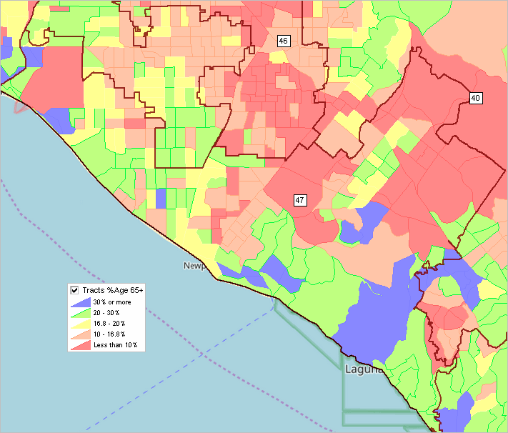
• Using Census 2020 Data with CBSA Vintage 2023 CBSA/Metro Delineations. See details (7/1/23). • Demographic Analytics Windows application/tool now available. See details below (7/24/23). • Census 2020 census tract to ZIP code area equivalence table (7/10/23) click here to use interactive table • Data access: get the Census 2020 report for a ZIP Code area; replace sample 85253 in link below, copy the whole link, paste in browser URL & enter. (7/3/23) https://data.census.gov/table?q=85253+dp1&tid=DECENNIALDP2020.DP1 • 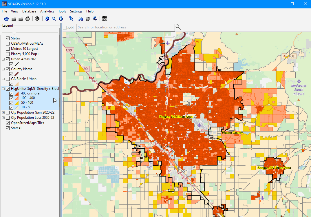 .. mapping statistical data .. use this
GIS project to examine patterns
of Census 2020 population/housing density by census block. Click graphic for larger view.
Gain insights into urban areas and "suburban" areas not formally defined
by the Census Bureau.
.. mapping statistical data .. use this
GIS project to examine patterns
of Census 2020 population/housing density by census block. Click graphic for larger view.
Gain insights into urban areas and "suburban" areas not formally defined
by the Census Bureau.
• The Census 2020 Demographic & Housing Characteristics (DHC) summary data files are the most detailed data from Census 2020 .. released on May 25, 2023. The DHC data are available in state-by-state downloadable zip files. Each state zip file expands to 44 data segments and one geographic reference segment -- all delimited files. We have developed dbase templates that can be used to organize the data for data access/extracts. Join the Tuesday/Thursday Data Analytics Web Sessions to learn more. • The Census 2020 total population counts are not yet available from the Census Bureau for the 118th Congressional Districts (CD 118). The 118th Congressional District Summary File is planned for release in August 2023. Those data will cover the same topics as covered in the 2020 Demographic and Housing Characteristics (DHC), see below, and include data for the 118th Congressional Districts and 2022 cycle state legislative districts. See the provisional CD 118 Census 2020 data developed using the census block to CD 118 equivalence file. Due for possible block-to-CD 118 changes occurring before release of the August CD 118 DHC, no changes are being made to the provisional CD 118 Census 2020 data. CD 118 data available based on the ACS 2021 1-year estimates (4 data profiles) may be downloaded here. The CD 118 ACS 2021 data may be accessed in interactive spreadsheet form or mapping/geospatial analysis form using VDA Desktop GIS or VDA Web GIS (select the Congressional District/SLD GIS project). • The Census 2020 Demographic and Housing Characteristics (DHC) data may now be accessed to the census block level using the Demographic Economic Data Explorer (DEDE). See the DEDE DHC section for a more complete description of how this works, a tutorial and examples. • The first more detailed Census 2020 subject matter data are to be released May 25th this week. See scope of subject matter to census block level at Census 2020 DHC (XLS). See more about the DHC data below. See about accessing "DP" and "DHC" data below. • Use the Census 2020 DHC (XLS) table PCT12* to uniquely examine characteristics of Millennials (born 1981 to 1996 and age 24 to 39 years in 2020) and Generation Z (born 1997 to 2012 and age 8 to 23 years in 2020) by single year of age (or as groups) by gender, iterated by race/origin, for each/all census tracts and higher level geography. • Examining school age population by block/school district .. the 2020 Census DHC file provides access to population by single year of age by gender for each/all census blocks (school districts, other geographies) in Table P14 .. see in Data Guide (XLS) .. ages under 1 year to 19 years. • The 2020 Census DHC file provides access to population by single year of age by gender, iterated by race/origin, for each/all census tracts in Table PCT12* .. see in Data Guide (XLS) .. ages under 1 year to 100 years and over. Weekly Web Sessions .. goto top Join us in the weekly data analytics web sessions where Census 2020 topics are always included. Importance of Decennial Census Data .. goto top Decennial census data, geographic and demographic data, are important for many reasons. Among these reasons is the required role of these data in the House of Representatives reapportionment and redistricting. These data are widely used for reapportionment and redistricting for state legislatures, special districts, cities, school districts and other geographies. Businesses and other organizations rely on these data for planning, marketing and evaluation. Researchers use these data for wide-ranging analyses. The decennial data are unique in providing demographic benchmark data for longitudinal analyses. Census Block GeoDemographics; Encino, CA Area .. only Census 2020 enables viewing/analyzing block data and related streets. 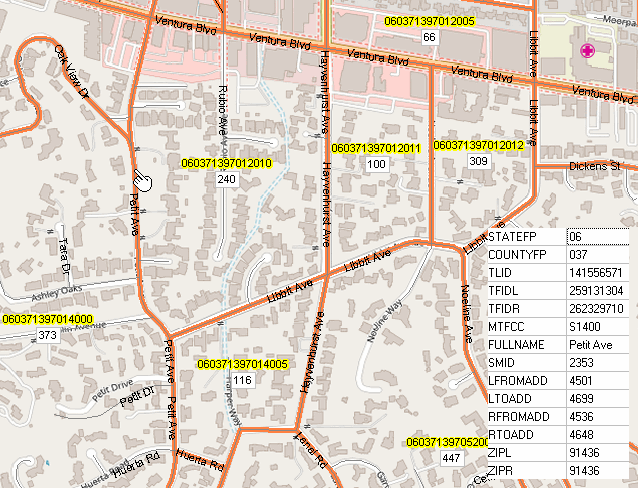 .. census blocks are shown with orange boundaries. .. pointer at street segment profiled in inset table. .. pointer in census block 060371387012010 showing Census 2020 population 240. About this Section .. goto top This section is focused on Census 2020 data resources and data access and use developed by Warren Glimpse/ProximityOne. This section is updated from time-to-time as Census 2020 related developments occur. Updates relating to this section are sent to members of the ProximityOne User Group (join now). Topics .. goto top 00 News, Blogs, Podcasts, Guide 01 Role & Scope; Timeline 02 Apportionment & P.L. 94-171 Redistricting Data 03 Geography, Geographic Data Resources; TIGER Digital Map Database 04 Demographic Profile File 05 Demographic and Housing Characteristics File (DHC) 06 Upcoming Summary Statistic Data 07 Public Use Microdata File 08 Special Tabulations 09 Data Access & Use 10 Demographic-Economic Data Explorer (DEDE) and Census 2020 11 VDA Web GIS and Census 2020 Census Block GeoDemographics Online 12 CV XE GIS MapBuilder using GeoGateway 00. News, Blog, Podcasts .. goto top News Click date link for details. 04.06.23. TIGER Vintage 2022 Smoothed (GENZ2022) Shapefiles Released 03.30.23. Connecticut County Geographic Changes
Changes in Connecticut county names, codes, and geography (see
Federal Register)
have been implemented with the Census Bureau's Population Estimates program effective
with the release of the March 26, 2023 county population estimates. The EstBase20 column in the table below shows the
adjusted Census 2020 (4/1/2020) population for these counties.
Blogs America's Changing Cities 118th Congressional District Demographic Characteristics The New Urban Geography Guide to Census 2020 Data Access & Use .. go to top .. an evolving informational resource .. used in web sessions .. covering basics, Census Data Access (CDA) usage, more advanced topics .. scope of geography and TIGER .. scope of subject matter .. about tables, items and other related terminology .. about the Census 2020 Demographic Housing Characteristics (DHC) "Census product" - available 5/25/23 - data to census block level; the first more extensive subject matter from Census 2020 - 2020 DHC Technical Documentation - 2020 DHC Tables & Items .. about related Census 2020 P.L. 94-171 data and other/future Census 2020 data to be released .. linking Census 2020 data with Census 2010 data, ACS data and non Census-sourced data .. Hawaii State DHC Demonstration Applications - downloading Hawaii State DHC population data from Census server (demo data at this time) - a zip file containing geoheader file and many segment files - converting Hawaii State DHC data into DBF structure - 2020 DHC Geoheader .. Census Data Access Program (CDAP) availability and use .. • a proprietary resource developed by ProximityOne (no affiliation/support by Census Bureau) • developed to support accessing and processing Census 2020 DHC data - features not supported by data.census.gov - aggregate block level data to custom defined geographies - develop custom extract files using template architecture .. GIS friendly structure .. dynamic computation of new data fields - relate Census 2010 and ACS annual data to Census 2020 data - prepare profiles and reports using template architecture • operates on a Windows computer and installed/updated using an installer • interactive user interface or batch operation 01. Role & Scope .. go to top Purpose As mandated by the U.S. Constitution Article I, Section 2, the U.S. census is conducted every 10 years to count every resident in the United States. The 2020 Census marked the 24th decennial census, the first was in 1790. Each home received an invitation to respond to a short questionnaire; online, by phone, or by mail. This is the first decennial census that everyone could respond to the census online. The data collected by the decennial census determine the number of seats each state has in the U.S. House of Representatives (apportionment) and is also used to adjust or redraw electoral districts based on where populations have increased or decreased. The results also inform decisions about allocating federal funding to communities across the country for hospitals, fire departments, schools, roads, and other critical programs and services. Census 2020 required counting an increasingly diverse and growing population of around 330 million people in more than 140 million housing units. To get an accurate count, the Census Bureau had to build an accurate address list of every housing unit, maximize self-response to the census, and efficiently follow up with those who did not self-respond. While the above is the Census Bureau stated purpose of Census 2020, most stakeholders have a far broader view of the purpose. Some argue that the geographic data produced as a "by-product" of the decennial census is the most valuable part. The number of users for purposes other than apportionment and funding distribution is far more than for those purposes alone. Geodemographic data from the decennial census provide a unique source of data at the census block level enabling analyses not otherwise possible. Scope The scope of subject matter data released for public use is limited by the questions asked on the Census 2020 questionnaire. Timeline First 2020 decennial census geography data released January 2021. - TIGER 2020 Digital Map Database files developed for use with GIS software. First 2020 decennial census demographic data released 4/26/21. State population totals for use in the apportionment of the U.S. House of Representatives. Congressional state apportionment data First detailed 2020 decennial census demographic data (P.L. 94-171) released 8/12/21. 02. Apportionment & P.L. 94-171 Redistricting Data .. go to top P.L. 94-171 Redistricting Data .. see details Designed for use in U.S. by State Reapportionment Primary more widely useful items:
03. Geography, Geographic Data Resources; TIGER Digital Map Database .. go to top Geographic Tallies by Type of Geographic Entity
Summary Level Codes .. go to top Census 2020 demographic data/summary statistics are tabulated/available by summary level (a three digit code). 010: Nation 020: Region 030: Division 040: State 050: County 060: Minor Civil Division/County Subdivision (MCD/CCD) 140: Tract 150: Block Group 160: Place 170: Consolidated City 101: Block (or 750 in P.L. 94-171 file) 230: Alaska Native Regional Corporation [Alaska Only] 280: American Indian Area/Alaska Native Area/Hawaiian Home Land 283: American Indian Area/Alaska Native Area (Reservation or Statistical Entity Only) 286: American Indian Area (Off-Reservation Trust Land Only)/Hawaiian Home Land 281: American Indian Tribal Subdivision 320: Metropolitan/Micropolitan Area 340: Combined Statistical Area 400: Urban Area 500: Congressional District 610: State Legislative District (Upper Chamber) 620: State Legislative District (Lower Chamber) 700: Voting District (precinct) 795: Public Use Microdata Area (PUMA) 860: ZIP Census Tabulation Area (ZCTA) 950: School District (Elementary) 960: School District (Secondary) 970: School District (Unified) Selected Geographies .. go to top • The New Urban Geography • 2020 Public Use Microdata Areas • 118th Congressional Districts • State Legislative Districts, 2020 cycle • Congressional Communities 3.1 TIGER Shapefiles • About TIGER Digital Map Database • TIGER Vintage 2020 Shapefiles .. more • TIGER Vintage 2021 Smoothed (GENZ2021) Shapefiles (released 4/25/22) • TIGER Vintage 2022 Smoothed (GENZ2022) Shapefiles (released 4/6/23) 3.2 Reference Files Census 2020 Block Address Count Lists .. released 03.01.20. .. more 3.3. Equivalence Files • Census 2010 to Census 2020 Tract Crosswalk Equivalence .. release 05.01.21. • Census 2020 to PUMA 2020 equivalence file • Census 2020 ZCTA to 2020 Census Tract Equivalence file (csv in zip file, Census version) - Census 2020 ZCTA to 2020 Census Tract Equivalence file (pdf, Census version) - see related Census 2020 ZCTA to 2020 Census Tract interactive table 04. Demographic Profile .. go to top Selected demographic and housing characteristics about local areas. Subjects: 5-year age groups, sex, race, Hispanic or Latino origin, household type, relationship to householder, group quarters population, housing occupancy, and housing tenure. Lowest level of geography: Census tract. Data Table Guide (XLSX): Includes the final list of tables, lowest level of geography by table and table shells for the Demographic Profile (and DHC). Access: ProximityOne data access/use tools; data.census.gov Release date: May 25, 2023 04a. Demographic Analytics Windows Application/Tool .. go to top Demographics Analytics last updated 8/17/23. Using Demographics Analytics (DA) .. use DA to compare the largest 10 cities and determine that the percent owner-occupied housing units ranges from 29.8% (New York) to 55.1% (Phoenix). This is one small example of the insights that can be created using the DA tool/data. Illustrative Video 1 Congressional Community & City Illustrative Video 2 Related saved HTML and XLS files: - HTML file - XLS file - Illustrative City(Omaha)-MSA(Omaha) HTML file DA Features - create a side-by-side profile for up to 10 areas. - use four methods to select comparative analysis geography. - when DA is run, the profiles display in the grid. .. grid profiles(s) can be saved as HTML or XLS. - use the included areas list file (list10a.txt) to compare the largest 10 cities. .. which includes the 10 largest population cities based on 2022 estimates Overview The Census 2020 Demographic Profile (DP1) has specific meaning and content as described above. The Demographic Analytics (DA) Windows application/tool has been developed to facilitate DP1 access and use for selected summary levels (e.g., U.S., states, counties, places, congressional districts, among others). An important feature of the DA tool is to provide access to/use of DP1 data for geography other than the summary levels accessible from the Census Bureau. Among these geographies are Congressional Communities and 2023 vintage CBSAs/Metros. This enables the user compare demographics for a congressional community (CC) side-by-side with, for example, another CC, corresponding congressional district or city/place. The start-up view shows the Phoenix, AZ city - Maricopa, AZ DP1 comparative analysis profile. DA Installation and Use Run the DA installer to install the DA application on a Windows computer. A userid and password are required. It is recommended that all installer defaults be accepted. The DA tool requires Internet. The DA application updates from time-to-time. Please register to keep up-to-date. Terms of use. There is no warranty for any aspect of using the DA application. The user is responsible for any use of the DA application. Neither the DA installer nor content installed on the user computer may be distributed. Data displayed in the grid or saved to file may be distributed or used in any manner so long as complete attribution is provided. DA Start-up View The DA start-up view shows the Phoenix, AZ city - Maricopa, AZ DP1 comparative analysis profile: 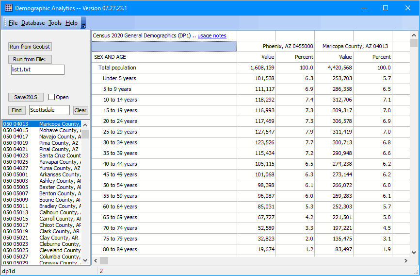 Creating DP1 Profiles There are 4 ways to create DP1 profiles. Profiles are displayed in the grid and then may be saved to HTML/XLS. The Clear button above the GeoList listbox will deselect/clear area selections. - dbl-click an area in the lower left listbox. - click a selection of areas in listbox -- then click "Run From GeoList" button. - create a GeoList text file -- then click "Run From File" button. - click a selection of areas in listbox, populating the textbox -- then click "Run From List" button. Scope and Interpretation of DA DP1 Data Notes about DP1 content: The DP1 profile includes these sections: - Population by gender by age - Population by race/ethnicity - Population by relationship - Households by type - Group quarters - Housing occupancy - Vacancy rates - Housing tenure There are 160 subject matter items included in the DP1 profile/table. Comparable Data Data included in the 2020 Census DP1 are similar in scope to the annually updated American Community Survey (ACS2021) Demographic Profile 5 ("DP5"). Comparison notes: The ACS 2020 1-year estimates should not be used due to pandemic impact. The ACS 2020 5-year estimates are centric to 2016 Most recent ACS data available: The ACS 2021 1-year estimates are conceptually a 1-year update to the Census 2020 DP1. - for geographic areas 65,000 population and over The ACS 2021 5-year estimates are centric to 2017 DA Usage In general, the DA application uses an API to retrieve data displayed in the grid. The start-up is the result of clicking the "Run from File" button that reads the "list1.txt" file. Summary Levels Access data for these summary levels (first three characters in the listbox, lower left) rows: .. geographic boundaries; as of Census 2020 unless noted 010 United States 040 States 050 Counties 160 Cities/Places 300 2020 CBSAs/Metros 301 2023 CBSAs/Metros [September 2023] 400 Urban Areas [Sepetmber 2023] 500 118th Congressional Districts [September 2023] 501 118th Congressional Communities {CA now available; remainder August 2023 860 2020 ZIP Code Tabulation Areas 900 School Districts [September 2023] Creating a DP1 Tables - DA does not presently enable creation of DP1 tables. - DP1 tables for summary levels described above are planned for access via VDA Web GIS in August 2023. Creating a DP1 profile in Grid - available geographies are shown in the listbox at lower left of user interface. - double-click a geographic area to display the DP1 profile for that area. - click Clear button to clear all selections in the GeoList listbox. Find Operation - click the Find button to find text/row containing text in edit box. - case sensitive text and exact spelling used in search. - use clear button to unselect all items in listbox. One-Area, Two-area, Multi-Area Profile To display a profile for two areas, one option is to click those areas in the listbox. - then click "Run from Geolist" button. Saving DP1 Data to File - HTML -- one or two areas/columns (leftmost) shown in grid - XLS -- all areas/columns shown in grid Notes about DP1 Profile Items X Not applicable. [1] The alone or in combination categories are tallies of responses rather than respondents. That is, the alone or in combination categories are not mutually exclusive. Individuals who reported two races were counted in two separate and distinct alone or in combination race categories, while those who reported three races were counted in three categories, and so on. For example, a respondent who indicated "White and Black or African American" was counted in the White alone or in combination category as well as in the Black or African American alone or in combination category. Consequently, the sum of all alone or in combination categories equals the number of races reported (i.e., responses), which exceeds the total population. [2] "Child" includes biological, adopted, and stepchildren of the householder. [3] "Own children" includes biological, adopted, and stepchildren of the householder. [4] The homeowner vacancy rate is the proportion of the homeowner inventory that is vacant "for sale." It is computed by dividing the total number of vacant units "for sale only" by the sum of owner-occupied units, vacant units that are "for sale only," and vacant units that have been sold but not yet occupied; and then multiplying by 100. [5] The rental vacancy rate is the proportion of the rental inventory that is vacant "for rent." It is computed by dividing the total number of vacant units "for rent" by the sum of the renter-occupied units, vacant units that are "for rent," and vacant units that have been rented but not yet occupied; and then multiplying by 100. End of subsection on the DA DP1 application .. go to top 05. Demographic and Housing Characteristics File (DHC) .. go to top DHC Data .. go to top The Census 2020 Demographic and Housing Characteristics (DHC) data may now be accessed to the census block level using the Demographic Economic Data Explorer (DEDE). See the DEDE DHC section for a more complete description of how this works, a tutorial and examples. The 2020 DHC data include the types of subject matter included in the 2010 Census Summary File 1 (2010 SF1). .. Some tables are repeated by race and ethnicity. Subjects: Age, sex, race, Hispanic or Latino origin, household type, family type, relationship to householder, group quarters population, housing occupancy, and housing tenure. Lowest level of geography: Varies, with many tables proposed at the census block level. Access: ProximityOne data access/use tools; data.census.gov Data Guide (XLS): Includes the list of tables and table shells for DHC. Release date: May 25, 2023 Using the Census API to Access Census 2020 DHC Data .. get DHC P14 all unified school districts .. Table P14 converted to xls .. School district profile Table P14 Downloading Census 2020 DHC Data .. State Folder .. Hawaii Geoheader File (dbf) Size and scope of DHC Summary File Data Even assuming data storage space at 4 bytes per item and not including zero-population census, the Census 2020 DHC-Summary File requires approximately 104 GB organized for direct data access. Population items Block level .. approximately 2,600 population items x ~7 million geographies (populated blocks plus higher level) =2600*7000000*4 =72800000000 bytes (storage at 4 bytes/item) Tract level up .. approximately 8,500 population items x ~150,000 geographies =8500*150000*4 =5100000000 bytes (storage at 4 bytes/item) Housing items Block level .. approximately 900 housing items x ~7 million geographies (populated blocks plus higher level) =900*7000000*4 =25200000000 bytes (storage at 4 bytes/item) Tract level up .. approximately 1,500 housing items x ~150,000 geographies =1500*150000*4 =900000000 bytes (storage at 4 bytes/item) DHC Table Shells 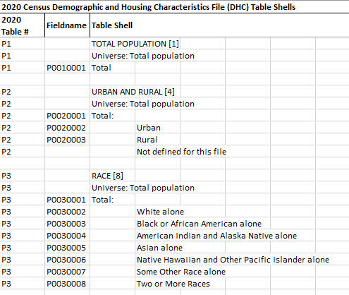 VDA Data Access Query Items= .. items is a comma-separated list of DHC fieldnames .. sumlev is one summary level as listed above. .. geoids is a comma-separated list of geoids. 06. Upcoming Summary Statistic Data .. go to top Release date: August & later, 2023 .. to be updated 118th Congressional District Summary File .. planned release date: August 2023 Detailed Demographic and Housing Characteristics File A (Detailed DHC-A) .. planned release date: September 2023 Detailed Demographic and Housing Characteristics File B (Detailed DHC-B) .. planned release date: To be determined Supplemental Demographic and Housing Characteristics File (S-DHC) 07. Public Use Microdata File .. go to top About Public Use Microdata Files (PUMS). 2020 Census privacy-protected microdata enable users to generate custom tabulations for subjects or geographies not included in the published tables. Census plans release of "Privacy-Protected Microdata Files" (PPMFs) from the production run of the DHC, The PPMFs will consist of separate files for people and housing units. Historically, the Census Bureau released a sample of records, called a Public Use Microdata Sample (PUMS). A new approach will better protect respondent privacy. While the data in the PPMFs may look like individual actual census records, all data are privacy-protected. They do not include any confidential census responses. Instead, the disclosure avoidance system ensures respondent privacy by applying differentially private statistical noise. 2020 Census PPMFs can provide the complete set of privacy-protected records for people and housing units. By contrast, the 2010 Census PUMS provided a 10% sample of the full census population, including records for approximately 30 million people and over 13 million housing units. As a result, the 2010 Census PUMS was impacted by sampling error in addition to error from the 2010 disclosure avoidance mechanisms. The 100% coverage of the 2020 PPMFs means that analyses of the 2020 files will only have to account for the controlled, limited uncertainty introduced by disclosure avoidance and not sampling error. It is presumed the only geography identified will be the 2020 PUMA, the lowest identifable geographic level. PPMFs will be released following the DHC release. Details forthcoming. 08. Special Tabulations .. go to top The Special Tabulations program (custom, fee reimburseable, tabulations) for decennial census data. Data Access & Use The Census Bureau data access program is located on the Web at data.census.gov For a quick lookup of area characteristics, consider QuickFacts. .. for example key in "quickfacts los angeles, ca" to find/view a profile. .. a few Census 2020 items are presented with data from other programs. 10. Demographic-Economic Data Explorer (DEDE) and Census 2020 .. go to top This application illustrates use of DEDE to extract a file comprised of a set of all Washington, DC Census 2020 block records from the Census 2020 P.L. 94-171 file using an API. The subject matter items are arrayed across the columns in the grid display. With DEDE running, make the settings as shown below and click the Start button. 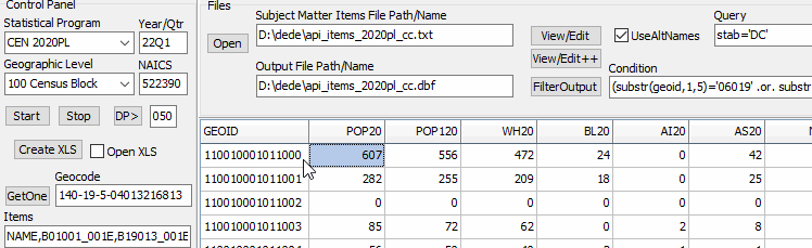 The settings are: Select the "Statistical Program" as "CEN 2020PL" -- Census 2020 P.L. 94-171 Select the "Geographic Level" as "100" -- census block. Set the "Subject Matter Items Path/Name" as D:\dede\api_items_2020pl_cc.txt Set the "Output File Path/Name" as D:\dede\api_items_2020pl_cc.dbf Set the "Query" as stab=DC Click the Start button to start the process. The grid populates as the processing completes. .. row 2, col 1 shows the GEOID, block code in this case, as 11 001 000101 1000. .. row 2, col 2 shows the total population of 607 for this block. The output file D:\dede\api_items_2020pl_cc.dbf is automatically written and can be optionally saved as XLS. View the XLS file here. View the Subject Matter Items file here. Access to DHP and DHC scheduled to be added in June 2023. 11. VDA Web GIS and Census 2020 .. go to top Using any browser (Chrome recommended) with most any device (Windows desktop/laptop) recommended, start VDA Web GIS and signin. See more about VDA Web GIS and getting started. After you signin, select the project Census 2020 Blocks. .. to be updated Decennial Census Integrated with Related Data .. go to top While the decennial census is a specific data collection and tabulation program, it closely integrates with several other Census Bureau programs. These include the American Community Survey (ACS), building permits and construction program (building permits), model-based population and housing estimates program (MDE), TIGER geographic database, among several others. Data Access, Integration, Analytics & Insights .. go to top ProximityOne Census 2020 data access and use tools enable you to use Census 2020 data alone or in combination with other data. We develop current estimates and projections using decennial census data with other data. • CV XE GIS -- GIS tools for mapping & geospatial analysis • Demographic Economic Data Explorer (DEDE) software • Explorer 360 interactive data access Terms of Use .. go to top There is no warranty associated with any aspect of this page, links or calendar. The user is solely responsible for any use made of this information. The content is subject to frequent update. For those interested in conveying this information to a stakeholder community, consider a link to this page. ProximityOne User Group .. go to top Join the ProximityOne User Group to keep up-to-date with new developments relating to metros and component geography decision-making information resources. Receive updates and access to tools and resources available only to members. Use this form to join the User Group. Support Using these Resources Learn more about accessing and using demographic-economic data and related analytical tools. Join us in a Data Analytics Web session. There is no fee for these one-hour Web sessions. Each informal session is focused on a specific topic. The open structure also provides for Q&A and discussion of application issues of interest to participants. Additional Information ProximityOne develops geodemographic-economic data and analytical tools and helps organizations knit together and use diverse data in a decision-making and analytical framework. We develop custom demographic/economic estimates and projections, develop geographic and geocoded address files, and assist with impact and geospatial analyses. Wide-ranging organizations use our tools (software, data, methodologies) to analyze their own data integrated with other data. Follow ProximityOne on Twitter at www.twitter.com/proximityone. Contact us (888-364-7656) with questions about data covered in this section or to discuss custom estimates, projections or analyses for your areas of interest. |
|
|