|
|
|
-- state legislative district geographic, demographic, economic characteristics -- post Census 2020 redistricting, election cycle 2022 .. how to find your state legislative district .. find by an address/location, view map .. step-by-step below. .. did you know .. there are 4,834 lower chamber (house) state legislative districts (SLDL) and 1,950 upper chamber (senate) state legislative districts (SLDU) .. 2022 cycle? As can be seen in the interactive table below, these collective 6,784 SLDs range in population from 2,942 (NH Lower 404) to 1,046,796 (CA Upper 039) based on American Community Survey 5-year estimates (ACS). See more about state legislative districts. Examine any State Legislative District using VDA Web GIS see steps below. Houston, TX SLDL 48134
.. for location of Memorial Park, Houston 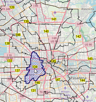
Houston, TX SLDU 48015
.. for location of Memorial Park, Houston 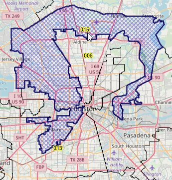
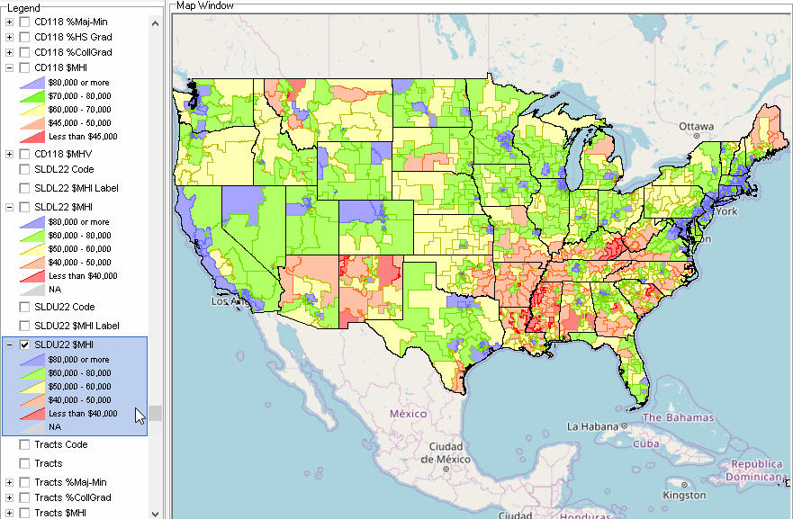
Gerrymandering and SLDs - an example, illustrating median household income Texas SLDU 48015 -- green, $70,643 Texas SLDU 48006 -- salmon, $49,146 Texas SLDU 48013 -- yellow, $70,643 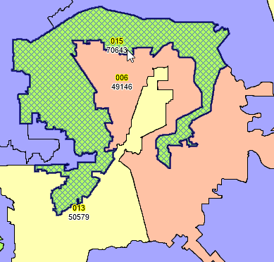 Based on ACS 2021 5 year estimates, 83 lower chamber/house vintage 2022 state legislative districts have a percent majority-majority population of 90% or more and 31 have a median housing value of more than $1 million. 19 upper chamber/senate vintage 2022 state legislative districts have a percent majority-majority population of 90% or more and 11 have a median housing value of more than $1 million. Use the interactive table below to learn more about these districts and your districts of interest. Use the VDA Web GIS to view state legislative district maps and characteristics using only a web browser. About State Legislative Districts .. goto top State legislative districts (SLDs) are areas from which members are elected to state or equivalent entity legislatures. SLDs include upper (senate—SLDU) and lower (house—SLDL) chambers of the state legislatures. Nebraska has a unicameral legislature and the District of Columbia has a single council, both of which are treated as upper-chamber legislative areas for the purposes of data access and use. There are no data by the lower house of the SLDs for Nebraska or the District of Columbia. State Legislative District (SLD) geography and data reviewed in this section are for SLDs in effect for the 2022 election cycle. SLDs are organized as State Legislative Districts - Upper Chamber (SLDUs) and State Legislative Districts - Lower Chamber (SLDLs). There are 1,955 SLDUs and 4,839 SLDLs. ProximityOne has developed a single national scope shapefile for use in Geographic Information System (GIS) applications for each SLDL and SLDU. These shapefiles have been developed by merging Census-sourced state by state shapefiles (SLDU and SLDL separately) and then clipping the boundaries at shoreline. Geospatial Analysis of SLDs using VDA Web GIS .. goto top Start VDA Web GIS and key in an address to view/analyze SLDs of interest. See step-by-step details below. Use the "Congressional District/SLD" Project with the VDA Web GIS to create maps and geospatially analyze SLDs in context of other geography and multi-sourced subject matter, There is nothing to install, requires only a browser and Internet. Start VDA Web GIS using most any browser (Chrome recommended) and any device (Windows desktop/laptop recommeded). Create map views such as those shown below. VDA GIS has been developed and is maintained by Warren Glimpse/ProximityOne/Alexandria, VA USA and Takashi Hamilton/Tsukasa/Osaka, Japan. All that is required to use VDA is a Web browser. iOS and Android versions are supported. VDA uses the same core structure as the Windows desktop VDA Desktop. Patterns of Economic Prosperity by State Legislative District .. goto top .. click graphic for larger view.
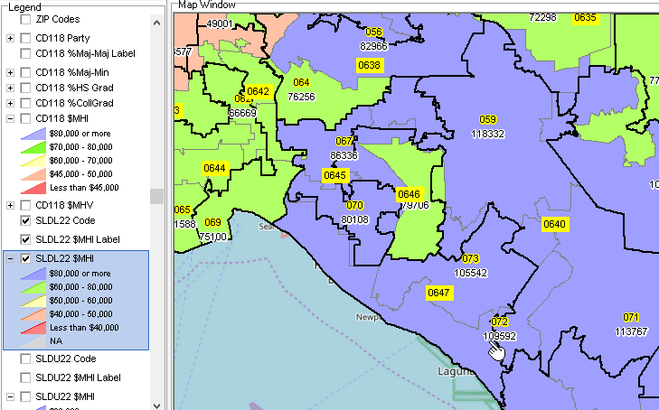
Patterns of median household income by Census Tract with Northern Virginia SLDLs - Lower .. Alexandria city VA shown with cross-hatch. SLDs labeled with SLD code and $MHI .. includes SLD Lower 51016 .. pointer at intersection of DC, VA, MD .. boundaries take effect for Virginia 2023 legislative elections .. click graphic for larger view. 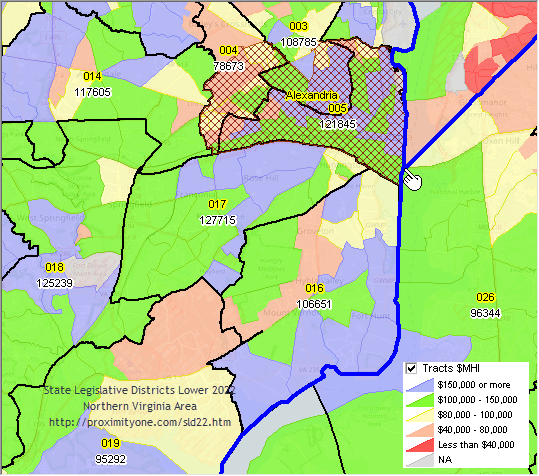 VDA Web GIS SLD Lower 51016 Demographic Profile (xls) .. based on ACS 2021 Patterns of median household income by Census Tract with Northern Virginia SLDUs - Upper .. Alexandria VA city shown with cross-hatch. SLDs labeled with SLD code and $MHI .. includes SLD Upper 51034 .. pointer at intersection of DC, VA, MD .. boundaries take effect for Virginia 2023 legislative elections .. click graphic for larger view. 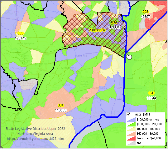 VDA Web GIS SLD Upper 51034 Demographic Profile (xls) .. based on ACS 2021 SLD Demographics .. integrated selected fields from the SLD22 ACS 5-year estimates .. developed all SLD22 ACS 5-year DP datasets (flat files, one record per SLD) .. Selected visual/mapped results shown below. State Legislative Districts 2022 Demographic Interactive Table .. goto top .. based on ACS 5-year estimates. .. access via Open VDA Web GIS in map or grid/table with SQL features. .. click column header to sort; click again to sort other direction. Table Usage Notes .. click ShowAll button between queries Column Headers; Subject Matter Items - SLDID - State Legilative District Code - ST - USPS State abbreviation - SLDLST - SLD Code - Type - SLD Type (L or U) - D001 - Total Population - MajMin - percent majority minority population - D037 - One Race -- White - D038 - One Race -- Black or African American - D039 - One Race -- American Indian and Alaska Native - D044 - One Race -- Asian - D052 - One Race -- Native Hawaiian and Other Pacific Islander - D057 - One Race -- Some Other Race - D058 - Two or more races - D071 - Hispanic or Latino (of any race) - D077 - Not Hispanic or Latino -- White Alone - D078 - Not Hispanic or Latino -- Black or African American Alone - D087 - Citizen, 18 and Over Population - D088 - Citizen, 18 and Over Population - Male - D089 - Citizen, 18 and Over Population - Female - S067 - Educational Attainment -- Population 25 Years and Over -- Percent High School Graduate or Higher - S068 - Educational Attainment -- Population 25 Years and Over -- Percent Bachelor's Degree or Higher - E062 - Median Household Income - E063 - Mean Household Income - E119 - Percent Families whose income past 12 months below poverty level - E128 - Percent All People whose income past 12 months below poverty level - H001 - Total Housing Units - H002 - Occupied Housing Units - H003 - Vacant Housing Units - H004 - Homeowner Vacancy Rate - H005 - Rental Vacancy Rate - H046 - Tenure -- Owner-Occupied - H047 - Tenure -- Renter-Occupied - H089 - Median Housing Value - H134 - Median Rent - H141 - Gross rent to household income ratio -- 30.0 to 34.9 percent (GRAPI) - H142 - Gross rent to household income ratio -- 35.0 percent or more (GRAPI) Find a State Legislative District .. goto top Use the Open VDA (Visual Data Analytics) Web GIS (Geographic Information System) .. OVDAW .. to find a state legislative district (SLD). Follow the steps below to find an SLD by address/location and view in map OVDAW may be used with most any browser and device. .. nothing to install, no fee and no login • About OVDAW • Click to start OVDAW Find a State Legislative District - House/Lower Chamber 1. Select the active layer as "St Leg Dist Lower $MHI" in the upper left dropdown. 2. Enter reference address/location into the Search bar above map window and press enter. for example "Memorial Park, Houston" (no quotes) the map window refreshes with a zoom to that location shown with a blue marker. 3. Click the marker to show this SLDL and profile in lower left. the SLDL for this location shows a crosshatched; navigate to view entire SLD. this is SLDL 48134 and has total ACS population estimate of 134,430. 4. Click the HTML button below the lower left profile to view an HTML profile in a new window. see that SLDL 48134 has a ACS median household income of $115,249. 5. To view SLDL boundaries and codes in the map, in the legend panel click the checkbox on for: - St Leg Dist Lower Code - St Leg Dist Lower $MHI Find a State Legislative District - Senate/Upper Chamber 1. Select the active layer as "St Leg Dist Upper $MHI" in the upper left dropdown. 2. Enter reference address/location into the Search bar above map window and press enter. for example "Memorial Park, Houston" (no quotes) the map window refreshes with a zoom to that location shown with a blue marker. 3. Click the marker to show this SLDU and profile in lower left. the SLDU for this location shows a crosshatched; navigate to view entire SLD. this is SLDU 48006 and has total ACS population estimate of 978,234. 4. Click the HTML button below the lower left profile to view an HTML profile in a new window. see that SLDU 48006 has a ACS median household income of $49,146. 5. To view SLDU boundaries and codes in the map, in the legend panel click the checkbox on for: - St Leg Dist Upper Code - St Leg Dist Upper $MHI Examining SLDs using VDA GIS .. goto top Option 1 Using Open VDA Web GIS The Open VDA (Visual Data Analytics) Web GIS (Geographic Information System) .. OVDAW ..uses a frequently updated "Base GIS Project" that provides access to State Legislative District (SLD) geodemographics as well as many other layers and subject matter. OVDAW may be used with most any browser and device. .. there is nothing to install. .. OVDAW is no fee and no login .. note the "Base Project" may be used with other VDAGIS tools, described in the VDAGIS Framework section. • About OVDAW • Click to start OVDAW Steps to view and examine a SLD using OVDAW Consider application where you want to learn about the SLDU for a particular location or address. .. in this example, ZIP code 85258 is used for the location. .. the intermediate results of the steps described below are shown in the graphic below. Start OVDAW (desktop recommended) .. after the map displays, proceed as follows (see graphic below as a guide): .. in the upper left dropdown select the active layer "St Leg Dist Upper $MHI" .. in the searchbar above the map, enter 85258 and press enter the view zooms to that location and shows a blue triangle marker .. in the legend panel at the left, click the checkbox on for: St Leg Dist Upper Code St Leg Dist Upper $MHI .. the SLDU boundaries and labels now show in the map window .. navigate to a view similar to the one shown below This view shows the Scottsdale, AZ area with SLDU boundaries. .. the marker is in SLDU "04004" (SLD 4 in Arizona) .. the upper label shows the within state SLDU code .. the lower label shows the ACS 2021 5 year estimate of median household income. Note the profile for the selected SLD shows in lower left when the SLD is clicked in map window. 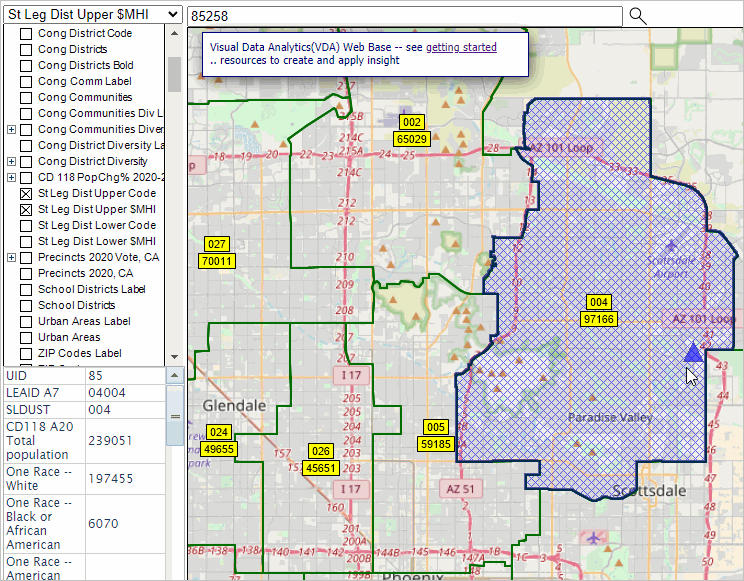 Variation .. viewing the SLDU with table/grid. .. the query "GEOID like '04%' selects on Arizona SLDUs. .. the sort "E062 desc" sorts the grid on item E062 ($MHI). .. not shown here, the GEOID, D001 and E062 were selected from the larger set of subject matter available. 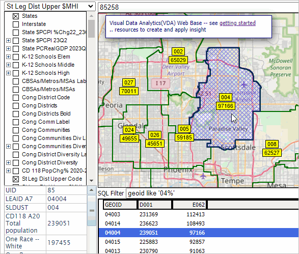 Option 2 Use Start VDA Web GIS and select the "Congressional District/SLD" Project. The steps below are focused on the Houston, TX area. Steps and methods apply anywhere in the U.S. With the project open, proceed as follows: State Legislative District - Lower 1. Select the active layer as "SLDL22 Code" in the upper left dropdown. 2. Key the address "Memorial Park, Houston" into the Search bar above map window and press enter. the map window refreshes with a zoom to that location shown with a blue marker. 3. Click the marker to show this SLDL and profile in lower left. this is SLDL 48134 and has total ACS 2021 5 yr population of 134,430. 4. Click the HTML button below the lower left profile to view an HTML profile in a new window. see that SLDL 48134 has a ACS 2021 5 yr median household income of $115,249. Houston, TX SLDL 48134 State Legislative District - Upper 1. Select the active layer as "SLDU22 Code" in the upper left dropdown. 2. Key the address "Memorial Park, Houston" into the Search bar above map window and press enter. the map window refreshes with a zoom to that location shown with a blue marker. 3. Click the marker to show this SLDU and profile in lower left. this is SLDU 48015 and has total ACS 2021 5 yr population of 950,356. 4. Click the HTML button below the lower left profile to view an HTML profile in a new window. see that SLDU 48015 has a ACS 2021 5 yr median household income of $70,643. Houston, TX SLDU 48015 Support Using these Resources .. goto top Learn more about demographic economic data and related analytical tools. Join us in a Web session. There is no fee for these one-hour Web sessions. Each informal session is focused on a specific topic. The open structure also provides for Q&A and discussion of application issues of interest to participants. ProximityOne User Group Join the ProximityOne User Group to keep up-to-date with new developments relating to geographic-demographic-economic decision-making information resources. Receive updates and access to tools and resources available only to members. Use this form to join the User Group. There is no fee. Additional Information ProximityOne develops geographic-demographic-economic data and analytical tools and helps organizations knit together and use diverse data in a decision-making and analytical framework. We develop custom demographic/economic estimates and projections, develop geographic and geocoded address files, and assist with impact and geospatial analyses. Wide-ranging organizations use our tools (software, data, methodologies) to analyze their own data integrated with other data. Follow ProximityOne on Twitter at www.twitter.com/proximityone. Contact ProximityOne (888-364-7656) with questions about data covered in this section or to discuss custom estimates, projections or analyses for your areas of interest. |
|
|