
|
|
|
2020 Digital Map Database
March 2020 .. the 2020 Digital Map Database U.S. national scope intersection-to-intersection road/line segments and associated address data. It includes boundary and reference files for wide-ranging official political/statistical geography down to the census block level, generally as of January 2020. This section reviews resources for geographic reference and statistical mapping, and geography for routing logistics and optimization .. the Census Bureau TIGER/Line, a continuously updated geographic database. TIGER is used for geographic reference and geospatial processing of data from various Census statistical programs including the decennial census Census 2020 and American Community Survey (ACS 2020). The public use version of TIGER is released annually that includes updates developed during the year. ProximityOne integrates the TIGER geographic updates in the ProximityOne Digital Map Database. Warren Glimpse, founder of ProximityOne, developed the GBF/DIME used as the prototype for TIGER/Line development. Using GIS & GeoDemographics
Whether you are a
GIS
user or not yet using GIS, you can benefit from our self-paced, online course
Using GIS & GeoDemographics.
Learn more about using wide-ranging geography and subject matter to develop reference and thematic maps.
Develop skills to perform site analysis, develop site reports, perform geospatial analysis.
Integrate anyy/all of the TIGER data in to your GIS projects.
See additional information.
Mapping Census Blocks Using TIGER Graphic below illustrates use of TIGER census block shapefile to show census blocks for two Ohio counties in context of 2018 CBSAs/Metros. Clicking on a census block shows a mini profile for that block. 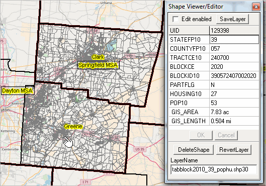 - view developed using ProximityOne CV XE GIS and related GIS project. Accessing & Using TIGER Files Download and integrate TIGER files into your GIS application using the ProximityOne CV XE GIS GeoGateway feature. Create maps structured to meet your objectives. See more information about TIGER file availability and access below in this section. 2020 Shapefiles and Datasets Related to TIGER Shapefiles and datasets derived from or related to TIGER 2020 include many types of geography and data. The data are developed in the form of shapefiles and dbase files that may be used directly with the ProximityOne CV XE GIS software at no fee. Perform wide-ranging mapping and geospatial analysis applications using these GIS resources. See more about mapping statistical data. • 2020 Census Block Shapefiles • 2020 Road/street Shapefiles • 2020 City/Place Shapefiles (Jan. 1, 2020) • 2018 Cycle State Legislative District Shapefiles (Jan 2020 sessions) • 116th Congressional Districts Shapefile • Block Groups Shapefiles • Census Tracts Shapefiles • Counties Shapefiles • Core-Based Statistical Areas (CBSA) Metro Shapefiles (Sep 2018 vintage) TIGER 2020 P.L. 94-171 Documentation (PDF) TIGER 2020 Documentation (PDF) 2020 TIGER/DMD Shapefiles & Related Files .. goto top .. by Type and Availability by Geography .. learn to use these files in the GIS & Using GeoDemographics course
Relationship files
Illustrative Application .. goto top The following graphic shows an example of using TIGER shapefiles in a regional context. These applications focus on an area in the Kansas City, MO-KS metro. See the related, more detailed, information about this application in the TIGER/Line 2017 Roads section. - zoom-out to national view or zoom-in to intersection level. - Starbucks locations (red markers) shown to illustrate use/integration of address-based data. - metro counties are shown using the counties shapefile - Kansas City, MO (orange cross-hatch pattern) shows use of the city/places shapefile.  TIGER 2020 File Structure & Availability TIGER 2020 files may be accessed using the ProximityOne CV XE GIS GeoGateway feature. See these details about using the GeoGateway operations. TIGER 2020 all lines shapefiles include 67.0 million line segments (mainly roads and streams): • approximately 42.8 million line segments are roads (typically intersection to intersection). • among road segments, 31.4 million segments have a populated name field; .. the remaining 11.4 million road segments have no name assigned. • among road segments, 16.9 million segments have an assigned left-side low address field; .. the remaining 25.9 million segments have no address in the left-side low address field. Data for each of these fields and others are provided for each county in the interactive table below. ProximityOne Roads Shapefiles & Database ProximityOne roads shapefiles include 100% compatibility with the Census Bureau version with added features and accessibility; nothing is lost, much is gained. ProximityOne version: • has updated and improved coverage of ZIP code assignment to right and left side of segment. • includes an extended set of right and left side segment geocodes (e.g., city, CBSA, school district, others). • includes latitude-longitude from and to segment end-points. • includes all lines (streams, rails, etc.), not only roads (roads identifier include for easy query). • available as dBase only for non-GIS applications. .. dBase/attributes file alone (without .shp) not available from Census. .. road segment attributes file alone also available as CSV. .. optionally eliminate role of shapefile and dBase file structure altogether. • ready-to-use shapefiles on DVD (or download from our server -- immediate access). .. just put the disc into a drive and directly add road shapefiles to your GIS project. .. no unzipping, no hard disk space usage (optionally copy to hard disk). • includes user application support. About TIGER/Line .. goto top TIGER/Line shapefiles are created from the Census Bureau's TIGER (Topologically Integrated Geographic Encoding and Referencing) database of selected geographic and cartographic information. TIGER is used by the Census Bureau to support the mapping and related geographic activities required by the decennial and economic censuses and statistical survey programs. TIGER/Line shapefiles are available for public use and are typically used to provide the digital map base for GIS (Geographic Information System) and mapping applications. TIGER/Line files are digital, vector-based point, line and polygon shapefiles and related files. TIGER/Line shapefiles do not contain any demographic or other subject matter data though wide-ranging subject matter data can be knit-together with the shapefiles. ProximityOne User Group Join the ProximityOne User Group to keep up-to-date with new developments relating to metros and component geography decision-making information resources. Receive updates and access to tools and resources available only to members. Use this form to join the User Group. Support Using these Resources Learn more about accessing and using demographic-economic data and related analytical tools. Join us in a Data Analytics Lab session. There is no fee for these one-hour Web sessions. Each informal session is focused on a specific topic. The open structure also provides for Q&A and discussion of application issues of interest to participants. Additional Information ProximityOne develops geodemographic-economic data and analytical tools and helps organizations knit together and use diverse data in a decision-making and analytical framework. We develop custom demographic/economic estimates and projections, develop geographic and geocoded address files, and assist with impact and geospatial analyses. Wide-ranging organizations use our tools (software, data, methodologies) to analyze their own data integrated with other data. Follow ProximityOne on Twitter at www.twitter.com/proximityone. Contact us (888-364-7656) with questions about data covered in this section or to discuss custom estimates, projections or analyses for your areas of interest. | |||||||||||||||||||||||||||||||||||||||||||||||||||||||||||||||||||||||||||||||||||||||||||||||||||||||||||||||||||||||||||||||||||||||||||||||||||||||||||||||||||||||||||||||||||||||||||||||||||||||||||||||||||||||||||||||||||||||||||||||||||||||||||||||||
|
|