CV XE GIS Home Page


  ProximityOne Main

  VDA Web GIS

  Situation & Outlook

  Related Sections
  - States
  - School Districts
  - Metros
  - Congressional
  - Counties
  - Census Tracts
  - Block Groups
  - Census Blocks
  - ZIP Codes
  - Urban Areas

  Estimates-Projections
  - 2060 Projections

  CV XE GIS
    Visual Analysis

  Interactive Tables


Navigating the U.S. Federal Statistical System
Decision-Making Information
  ProximityOne
  information resources & solutions
  (888) DMI-SOLN
  (888) 364-7656


Federal Statistical System Gateway
VDA Web GIS

click graphic for larger view

Data Analytics Blog
Mapping Statistical Data

Support & Technical Assistance
help using these resources


October 2023 .. how do I access income related measures for small areas? One example. Many Federal statistical programs produce these data. They are available at no cost. But how to find the right data, how to access the data, how to put the data into a usable form are often challenging. Am I using the best data for a my application? What are the options? Another challenge is integrating Federal statistical data with other data. What are the limitations of the data? How does this impact development of decision-making information? How to best use these data in collaboration?

This section is developed by Warren Glimpse, and is updated periodically. See related Data Analytics Blog. Glimpse is an econometrician, former associate director of the U.S. Office of Federal Statistical Policy & Standards and former Census Bureau senior statistician. Glimpse developed the Census Bureau TIGER digital map database prototype and Census Bureau State Data Center Program. He now principal at ProximityOne. E-mail Warren or call (888-364-7656) with questions/help.

This section is focused on accessing, integrating and using geostatistical data from the Federal Statistical System (FSS). It has been developed as a guide to help stakeholders, data users, navigate the FSS. FSS geographic, demographic, economic and related data update daily. This section updates frequently reflecting new and changing developments.

Join us in the weekly web meetings (every Tuesday 3:00 pm ET) focused on Accessing & Using Demographic-Economic Data.

Upcoming, This Week & Recent -- Selected New Data Releases
01.20.24. Situation & Outlook Demographic-Economic Estimates/Projections to 2030 (ProximityOne)
        - geography: tract, county, metro, state & U.S.
        - related Demographics 2060

12.15.23. 2022 Small Area Income and Poverty Estimates (Census); school district & county
        - related SAIPE


12.07.23. QCEW Quarterly 2023Q2 U.S. by County Establishments, Employment, Earnings (BLS)
        - updated quarterly/annual time series
        - by type of business/NAICS
        - access via DEDE.
        - related Regional Economic Information System

12.07.23. Gross Domestic Product by County and Metropolitan Area, 2022 (BEA); updated annual time series
        - related Regional Economic Information System

12.07.23. 2022 American Community Survey 5-year estimates (Census); data to block group level
        - related 2022 American Community Survey

11.20.23. U.S. by County Population by Age, Race/Ethnicity, Gender Annual Projections to 2060 (ProximityOne)
        - aggregates to metro, state & U.S.
        - related Demographics 2060

11.16.23. Personal Income by County and Metropolitan Area, 2022 (BEA); updated annual time series
        - related Regional Economic Information System

10.31.23. TIGER Digital Map Database (Census); 2023 vintage released
        - Topologically Integrated Geographic Encoding & Referencing Data

09.14.23. Census .. American Community Survey 2022 1-year Estimates
Updated annually. Access via VDA Web GIS & DEDE custom download & Situation & Outlook report.
The American Community Survey (ACS) is a national program providing annually updated demographic-economic data for national and sub-national geography .. to the block group level .. read more

09.06.23. BLS .. Quarterly Census of Employment & Wages 2023Q1
Updated quarterly. Access via VDA Web GIS & DEDE custom download & Situation & Outlook report.
Quarterly Census of Employment and Wages (QCEW) provides a quarterly count of employment and wages reported by employers covering more than 95 percent of U.S. jobs, available at the county, MSA, state and national levels by industry .. read more

12.08.22. Census .. American Community Survey 2021 5-year Estimates
Updated annually. Access via VDA Web GIS & DEDE custom download & Situation & Outlook report.
The American Community Survey (ACS) is a national program providing annually updated demographic-economic data for national and sub-national geography .. to the block group level .. read more

12.06.22. BLS .. Quarterly Census of Employment & Wages 2022Q2
Updated quarterly. Access via VDA Web GIS & DEDE custom download & Situation & Outlook report.
Quarterly Census of Employment and Wages (QCEW) provides a quarterly count of employment and wages reported by employers covering more than 95 percent of U.S. jobs, available at the county, MSA, state and national levels by industry .. read more

12.02.22. BLS .. Employment Situation for November 2022
Updated monthly.
Total nonfarm payroll employment increased by 263,000 in November 2022, and the unemployment rate was unchanged at 3.7 percent. Notable job gains occurred in leisure and hospitality, health care, and government. Employment declined in retail trade and in transportation and warehousing .. read more

11.29.22. FHFA .. Metro Housing Price Index 2022Q3
Updated quarterly. Access these data for integrated, geospatial analysis via VDA Web GIS.
The North Port-Sarasota-Bradenton, FL metro ranked number one with the highest percent housing price increase among the largest 100 metros over the past year (2021Q3 to 2022Q3) .. 29.2%, and 2.5% over the past quarter. In the U.S., housing prices rose by 12.4% over the past year with no change in the last quarter.
The Housing Price Index (HPI) is a broad measure of the movement of single-family house prices. It serves as a timely, accurate indicator of house price trends at various geographic levels. It also provides housing economists with an analytical tool that is useful for estimating changes in the rates of mortgage defaults, prepayments and housing affordability in specific geographic areas. The HPI is based on data developed by Fannie Mae and Freddie Mac .. read more .. download as text file

11.26.22. Census .. New Authorized Residential Construction by Place/County October 2022
Updated monthly. Access these data via VDA Web GIS & DEDE Situation & Outlook report.
Privately-owned housing units authorized by building permits in October were at a seasonally adjusted annual rate of 1,526,000. This is 2.4 percent below the revised September rate of 1,564,000 and is 10.1 percent below the October 2021 rate of 1,698,000. Single-family authorizations in October were at a rate of 839,000; this is 3.6 percent below the revised September figure of 870,000. Authorizations of units in buildings with five units or more were at a rate of 633,000 in October .. read more .. see related

11.16.22. BEA .. Personal Income by County and Metropolitan Area, 2021
Updated annually; U.S. by county (and more) time series.
In 2021, personal income increased in 3,075 counties, decreased in 36, and was unchanged in 3. Personal income increased 7.4 percent in the metropolitan portion of the United States and 7.7 percent in the nonmetropolitan portion .. read more

11.10.22. BLS .. Consumer Price Index for October 2022
TThe Consumer Price Index for All Urban Consumers (CPI-U) rose 0.4 percent in October on a seasonally adjusted basis, the same increase as in September. Over the last 12 months, the all items index increased 7.7 percent before seasonal adjustment .. read more

10.06.22. BEA .. Personal Consumption Expenditures by State, 2021
State personal consumption expenditures (PCE) increased 12.7 percent in 2021 after decreasing 1.9 percent in 2020. The percent change in PCE across all 50 states and DC ranged from 16.3 percent in Utah to 9.4 percent in New York .. read more


Topics
  • 01 Navigating the Federal Statistical System
  • 02 Accessing & Using Federal GeoStatistical Data
    .. DEDE -- Demographic-Economic Data Extraction & Integration
    .. VDA -- Visual Data Analytics (VDA) Web GIS
    .. Situation & Outlook -- Integrated Demographic-Economic Estimates & Projections
    .. Advisory Services -- getting answers to questions; knitting data together; using the data
  • 03 About this document & Terms of Use
  • E-mail us with questions about this document or related tools/data reviewed

FSS Overview
The U.S. Federal Statistical System offers a vast array of diverse data resources that are useful in wide-ranging planning and analytical applications. Many of these data resources, such as census block level demographics from the decennial census, are unique in scope and content; in many cases there are no alternative data resources.

But there are issues/challenges facing the data user to navigate the Federal Statistical System. Examples ... the Bureau of Labor Statistics releases total employment data by county quarterly and monthly through multiple programs. The data values differ, for methodological reasons, but the net result can be confusion for data users. The Census Bureau releases total employment data from many statistical programs by county both annually and more frequently. Where are these alternative total employment data and how can they be accessed? How do these various measures differ and which data are right for my situation? This section provides basic statistical program information. Subsequent updates will provide more detail.

Navigating the Federal Statistical System & Data Access -- see below.
While the FSS is focused on agencies that collect, develop and make available statistical data, there is a broader set of data and resources that relate to accessing and using these data. As technology and related data analytics resources have evolved, access to and use of these data is closely associated with the development of geographic data by Federal statistical and other agencies and Geographic Information Systems (GIS).

Related Topics
  • Washington Post: How the U.S. National Statistics System Works

The FSS is a decentralized set of agencies that collect, develop and make available statistical and geographic data. The OMB Office of Statistical Programs and Standards (SPS) provides a limited FSS coordinative role. The SPS establishes statistical policies and standards, identifies priorities for improving programs, evaluates statistical agency budgets, reviews and approves Federal agency information collections involving statistical methods, and coordinates U.S. participation in international statistical activities. SPS is housed within the OMB Office of Information and Regulatory Affairs (OIRA) and has little public visibility. SPS provides no data access operations.

An example of SPS operations are organizing steps/meetings that result in the proposed changes (see Federal Register post) to OMB's metropolitan and micropolitan statistical area standards by the Metropolitan and Micropolitan Statistical Area Standards Review Committee (facilitated by SPS).

Standards and policies relating to race/ethnic data collected and tabulated by the Federal government were established/published by SPS, again through interagency meetings and coordination. Yet SPS does not actually collect, develop or disseminate any race/ethnic data.

All Federal statistical survey and data collection forms/operations must be reviewed and approved by SPS before being used by an agency. Examples of this are data collection forms developed by the Census Bureau for Census 2020 and the American Community Survey. Yet, SPS has no role in actually collecting or tabulating data collected through use of the forms/data collection instruments.

While the FSS spans more than 100 agencies, the 13 "principal statistical agencies" have statistical work as their principal mission. The principal statistical agencies include:
  • Census Bureau (Commerce)
  • Bureau of Economic Analysis (Commerce)
  • Bureau of Justice Statistics (Justice)
  • Bureau of Labor Statistics (Labor)
  • Bureau of Transportation Statistics (Transportation)
  • Economic Research Service (Agriculture)
  • Energy Information Administration (Energy)
  • National Agricultural Statistics Service (Agriculture)
  • National Center for Education Statistics (Education)
  • National Center for Health Statistics (CDC/HHS)
  • National Center for Science and Engineering Statistics -- NSF/Independent
  • Office of Research, Evaluation, and Statistics -- SSA/Independent
  • Statistics of Income (IRS)

There are hundreds of additional ongoing Federal programs (outside of the above agencies) that conduct statistical activities in conjunction with another program mission. These statistical programs are components within a Federal department or other agency. They include a broad set of centers, institutes and organizations in addition to the 13 principal statistical agencies. Many of these programs produce data accessible for public use, some routinely updated, many in a near ready-to-use data file structure suitable for integrating with other data.

There are also Federal agencies whose statistical activities are not part of the Executive Branch. These agencies include the Congressional Budget Office, which develops and applies projection models for the budgetary impact of current and proposed Federal programs; the Federal Reserve Board, which compiles the widely used Flow of Funds report and other statistical series and periodically conducts the Survey of Consumer Finances; and the U.S. Government Accountability Office, which uses statistical data in evaluations of government programs.

Navigating Access to Federal Statistical Data .. goto top
Footnotes (in the form 1,2/ or 2/) refer to additional detail provided shown below the table.
Federal multi-agency/program   related ProximityOne sections
  -- limited integrated data access
  -- most multi-agency/program data in GIS applications
  -- vary widely by data access beyond mapping operation
  - Situation & Outlook (S&O)
  - ProximityOne Data Services (PDS)
  - Interactive Data Tables
  - Metro Situation & Outlook Reports
  - State & Regional Data Resources (SRDMI)
  - America's Communities Program (ACP)
  - Demographic-Economic Data Extraction (DEDE)
  - CV XE GIS -- integrative, ready-to-use GIS projects
  - Visual Data Analytics -- VDA Mapserver

Census Bureau   related ProximityOne sections
  - "Explore Census Data" primary online access across all programs
  - WWW2-FTP primary FTP downloads for most programs
  ...
  ... 1,2/
 
  Census Bureau API Tools - Available Data
  related ProximityOne section
  - Decennial Census     - DEDE API Tools
 
  Census 2020
  related ProximityOne section
  - P.L. 94-171 Redistricting Data     - P.L. 94-171 Redistricting Data
  - Demographic Profile Summary File -- details not yet available     - Demographic Profile Summary File -- details not yet available
 
  Census 2010
  related ProximityOne sections
  - P.L. 94-171 Redistricting Data     - P.L. 94-171 Redistricting Data
  - Demographic Profile Summary File -- FTP     - Demographic Profile Summary File
  - Summary File 1 FTP     - Summary File 1 & Census blocks
  - Summary File 1 Urban-Rural FTP     - Mapping Urban/Rural Census Blocks/Demographics
  - Summary File 2 FTP     - Summary File 2
  - Public Use Microdata Sample FTP     - Public Use Microdata Sample
 
  American Community Survey (ACS)   related ProximityOne sections (ACS main)
  - ACS 2021 1-year estimates     - ACS 2021 1-year estimates main page
  - ACS 2020 5-year estimates (latest 5-year estimates in 3/2022)     - ACS 2020 5-year estimates main page
  - ACS 2019 1-year estimates     - ACS 2019 1-year estimates main page
  - ACS 2019 5-year estimates (latest 5-year estimates)     - ACS 2019 5-year estimates main page
  - ACS 2018 1-year estimates     - ACS 2018 1-year estimates main page
  - ACS 2018 5-year estimates     - ACS 2018 5-year estimates main page
  - ACS 2017 1-year estimates     - ACS 2017 1-year estimates main page
  - ACS 2017 5-year estimates     - ACS 2017 5-year estimates main page
  - ACS 2016 1-year estimates     - ACS 2016 1-year estimates main page
  - ACS 2016 5-year estimates     - ACS 2016 5-year estimates main page
  - ACS 2015 1-year estimates     - ACS 2015 1-year estimates main page
  - ACS 2015 5-year estimates     - ACS 2015 5-year estimates main page
  - ACS 2014 1-year estimates     - ACS 2014 1-year estimates main page
  - ACS 2014 1-year supplemental estimates
    .. includes areas with population 30,000 and over
    - ACS 2014 1-year supplemental estimates page
  - ACS 2014 5-year estimates     - ACS 2014 5-year estimates main page
  ... access by Census Online & downloads via WWW2     - Block groups
      - Census tract interactive tables
      - ZIP Code area interactive tables
      - School district interactive tables
      - City/place interactive tables
      - State, metro, county interactive tables
      - Public Use Microdata Area interactive tables
  - ACS Migration Special Tabulation
    .. there are many Census data resources measuring migration
    - County to County Migration
  - ACS Daytime Population Data     - City-County-State Daytime Population
    - County-State Daytime Population (2013)
  - ACS Public Use Microdata Sample Files     - ACS 2012 1-year PUMS Files
    - ACS 2013 1-year PUMS Files
 
  Other Statistical Surveys   related ProximityOne sections
  - Current Population Survey CPS: joint Census/BLS
  - custom estimates & analyses
  - Survey of Income and Program Participation SIPP
  - custom estimates & analyses
 
  Small Area Estimates (model based)   related ProximityOne sections
  - Annual population estimates
    .. includes annual births, deaths, migration; county up
  - County estimates dataset, profiles, interactive 1,2/
    .. get county profile; example for Cook County, IL
  - City/place estimates dataset, interactive table
  - Small Area Health Insurance Estimates (SAHIE)   - custom estimates & analyses
  - Small Area Income & Poverty Estimates (SAIPE)   - custom estimates & analyses
 
  Economic Statistics   related ProximityOne sections
  - Economic Census   - custom estimates & analyses
  - Economic Indicators   - custom estimates & analyses
  - County Business Patterns   - Business Patterns 1,2/
 
  Geography   related ProximityOne sections
  - TIGER/Line Files   - TIGER/Line
    .. TIGER 2021
    .. TIGER 2020
    .. TIGER 2019
    .. TIGER 2018
    .. TIGER 2017
    .. integrating with OpenStreetMaps
    .. Digital Map Database
  - ACS 2020 Geography/Geocodes
    .. used for Census 2020 and ACS 2020 tabulation geography
  - used in applications & analyyses
  - ACS 2019 Geography/Geocodes
    .. used for ACS 2019 tabulation geography
  - used in applications & analyses
  - ACS 2018 Geography/Geocodes
    .. used for ACS 2018 tabulation geography
  - used in applications & analyses
  - ACS 2015 Geography/Geocodes
    .. used for ACS 2017 tabulation geography
  - used in applications & analyses
  - Metropolitan Area Definitions
    .. defined by OMB based mainly on Census-sourced data
  - Metropolitan Areas
  - 2010 Public Use Microdata Areas
    .. statistical tabulation areas 100,000 population+
  - 2010 Public Use Microdata Areas
    .. get PUMA maps; profiles example for Texas

Bureau of Economic Analysis   related ProximityOne sections
  - Local Area Personal Income   - Regional Economic Information System 1,2/
  - State Personal Income   - State Personal Income 1,2/
  - State Personal Consumption Expenditures  
  - State GDP   - used in applications 1,2/
  - Metro GDP   - Metro GDP 1,2/
  - Gross Domestic Product   - used in applications 1,2/

Bureau of Labor Statistics   related ProximityOne sections
  - Consumer Expenditure Survey (CEX)   - custom estimates & analyses 2/
  - Consumer Price Index (CPI)   - custom estimates & analyses 2/
  - Census of Employment & Wages (CEW)   - Establishments, Employment & Earnings 1,2/
  - Local Area Unemployment Statistics (LAU)   - Local Area Employment Situation 1,2/
  - Current Employment Statistics - National   - custom estimates & analyses 2/
  - Current Employment Statistics - State & Area
    ... State & Metro Area Employment, Hours & Earnings
  - custom estimates & analyses 2/
  - Current Population Survey
    ... see also under Census Bureau
  - custom estimates & analyses 2/

Economic Research Service USDA   related ProximityOne sections
  - Supplemental Nutrition Assistance Program (SNAP)   - SNAP participation and benefit analyses

National Agricultural Statistics Service   related ProximityOne sections
  - County Annual Production Data   - agricultural market analyses

Energy Information Administration   related ProximityOne sections
  - U.S. Energy Mapping System
  - energy-related market analyses
  - Electric Power Plant Data (EIA-923)
  - energy-related market analyses
  - Crude Oil Pipelines shapefile
  - energy-related market analyses

National Center for Education Statistics   related ProximityOne sections
  - Common Core of Data school districts   - School Districts Datasets & Interactive Table
  - Common Core of Data schools   - Public Schools Datasets & Interactive Table
  - School District Special Tabulation   - School District Special Tabulation

National Center for Health Statistics   related ProximityOne sections
  - Bridged-Race Population Estimates   - Single Year of Age Demographics 2/
  - County-Level National Mortality File   - custom estimates & analyses 2/
  - Mortality Tables   - custom estimates & analyses 2/
  - NCHS County Urban-Rural File   - custom estimates & analyses
  - National Health and Nutrition Examination Survey   - custom estimates & analyses
  - National Health Interview Survey   - custom estimates & analyses

Health Resources Services Administration (HHS)   related ProximityOne sections
  - Area Resource Files
  - custom estimates & analyses
  - Health Professional Shortage Areas
  - custom estimates & analyses
  - Medically Underserved Areas
  - custom estimates & analyses
  - Primary Care Service Areas
  - custom estimates & analyses
  - National Survey of Nurse Practitioners
  - custom estimates & analyses

Centers for Medicare & Medicaid Services   related ProximityOne sections
  - HospitalCompare registry of Medicare hospitals
  - component of national hospitals database
      County Health Patterns
  - PhysicianCompare registry of Medicare physicians
  - component of national physicians database
      County Health Patterns

Federal Housing Finance Agency 5/   related ProximityOne sections
  - Housing Price Index metro, state, U.S.   - Housing Price Index 1,2/

Federal Deposit Insurance Corporation 6/   related ProximityOne sections
  - Institution & Branch Summary of Deposits   - Financial Institutions Markets

Federal Financial Institutions Examination Council   related ProximityOne sections
  - FFIEC Census and Demographic Data   - used in applications

Federal Bureau of Investigation   related ProximityOne sections
  - Uniform Crime Reports   - used in applications

IRS Statistics of Income   related ProximityOne sections
  - County to County Migration   - custom estimates & analyses 2/
  - ZIP Code Income   - custom estimates & analyses
  - County Income   - custom estimates & analyses

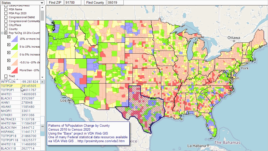
1/ augmented source data are component of PDS
2/ augmented source data are component of S&O
5/ FHFA: independent agency; regulates Fannie Mae, Freddie Mac, and the 12 Federal Home Loan Banks.
6/ FDIC: independent agency

Accessing & Using Federal Statistical Data .. goto top
This section is under progressive development.
E-mail us with questions about this document or related tools/data reviewed.

Demographic-Economic Data Extraction (DEDE) API Tools .. goto top
Use DEDE to develop your own custom datasets from wide-ranging Federal statistical programs.

Visual Data Analytics (VDA) Web GIS .. goto top
Use the VDA Web GIS to access/analyze data from wide-ranging Federal statistical programs.
  nothing to install, use any browser.
  get started at no cost.
  for example view/analyze block group demographic characteristics with a city/county/school district of interest

Situation & Outlook .. goto top
  -- ready-to-use (and custom) demographic-economic estimates & projections .. goto top
  -- more about Situation & Outlook

Advisory Services .. goto top
Many times data users have needs in accessing and integrating data to meet custom needs. ProximityOne/Warren Glimpse provides services that can help meet these needs.

  • What and where are Federal statistical data that might meet my needs?
  • Of the available Federal statistical data options, which is best to fit my needs?
  • What is the nature of geographic granularity of data; e.g., what data are available for all counties?
  • How do I build a time series of data that are reported periodically?
  • What are the limitations of data that are available?
  • Federal statistical data often lag by more than a year and/or are pre-pandemic. How do I get current data.

Examples
E1. I need demographic data by ZIP code. Where can I find it?"
A1. One of the most frequently asked questions, the only source of these data from the FSS (second to none on this subject) is the decennial census or American Community Survey (ACS) -- both Census Bureau programs.

From here, things can be more complicated ..
1) where is the most current data?
2) where similar options exist, how to compare among alternative data?
3) How do I access it on my computer?

About this Document & Terms of Use .. goto top
This document, developed by Warren Glimpse, is updated periodically. Updated information is posted on the Data Analytics Blog. Follow the blog to receive updates and/or join the Situation & Outlook User Group. Join now to receive e-mail updates and related member benefits.

ProximityOne User Group .. goto top
Join the ProximityOne User Group to keep up-to-date with new developments relating to metros and component geography decision-making information resources. Receive updates and access to tools and resources available only to members. Use this form to join the User Group.

Support Using these Resources .. goto top
Learn more about accessing and using demographic-economic data and related analytical tools. Join us in a Data Analytics Lab session. There is no fee for these one-hour Web sessions. Each informal session is focused on a specific topic. The open structure also provides for Q&A and discussion of application issues of interest to participants.

Additional Information .. goto top
ProximityOne develops geodemographic-economic data and analytical tools and helps organizations knit together and use diverse data in a decision-making and analytical framework. We develop custom demographic/economic estimates and projections, develop geographic and geocoded address files, and assist with impact and geospatial analyses. Wide-ranging organizations use our tools (software, data, methodologies) to analyze their own data integrated with other data. Follow ProximityOne on Twitter at www.twitter.com/proximityone. Contact us (888-364-7656) with questions about data covered in this section or to discuss custom estimates, projections or analyses for your areas of interest.


Copyright © . ProximityOne. All Rights Reserved.
Sitemap | Contact Us | News