
|
|
|
-- 2,378 statistical areas covering the U.S. and outlying areas -- developing and using custom demographic estimates -- expanding insights through data analytics August 2022 .. .. the 2020 American Community Survey (ACS) 5-year PUMS (Public Use Microdata Sample) data were released March 31, 2022. See more about the ACS 2020 5-year PUMS here. Public Use Microdata Areas (PUMAs) are used as a tabulation area for PUMS estimates. PUMAs provide most detailed U.S. wall-to-wall geography (2,378 areas) for which current year demographic-economic data are available and annually updated. Use the related Public Use Microdata Sample (PUMS) data to develop custom-defined subject matter estimates for one or all PUMAs. 2020 PUMAs
This subsection is about the 2020 PUMAs which were
defined/released in August 2022. There will be a new PUMA 2020 page in the near future.
In general, there is close geographic correspondence between the 2010 and 2020 PUMA vintages, but with many exceptions.
It matters if the boundaries differ as this limits the ability to perform 2010-2020 demographic change analysis.
The PUMA 2010 count for all states is 2,351 and the PUMA 2020 count is 2,461.
The U.S. national scope 2010 and 2020 PUMAs are now available in the VDA Web GIS MetroDynamics GIS project. See details here about using VDA/MatroDynamice with PUMAs integrated with other geography/subject matter The following graphic illustrates PUMA 2020 boundaries in the Los Angeles County area. There are 69 2010 PUMAs and 71 2020 PUMAs comprising Los Angeles County. 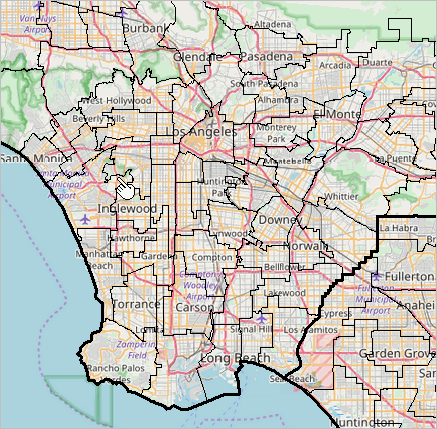
Click the graphic below for a larger view of this area. Expand browser window to full screen for best view. This view shows 2020 PUMAs with a black boundary and yellow PUMA code. 2020 black boundaries "sit above" orange 2010 boundaries. See at pointer, Culver City area, the PUMA areas/boundaries differ. 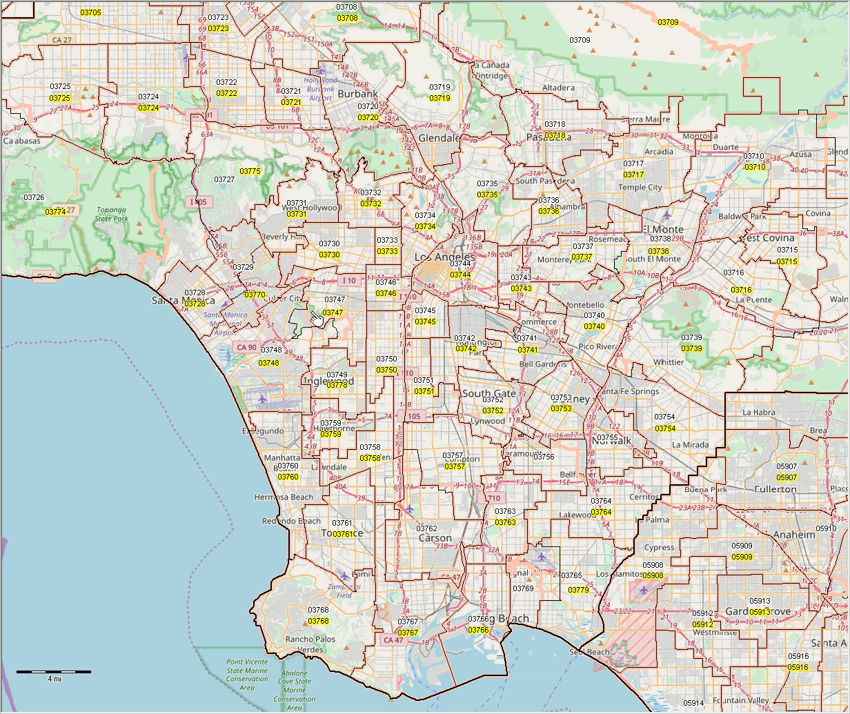
Click the graphic below for a larger view of this area without the topographic base file. Expand browser window to full screen for best view. This view shows 2020 PUMAs with a black boundary and yellow PUMA code. 2020 black boundaries "sit above" orange 2010 boundaries. See at pointer, Culver City area, the PUMA areas/boundaries differ. 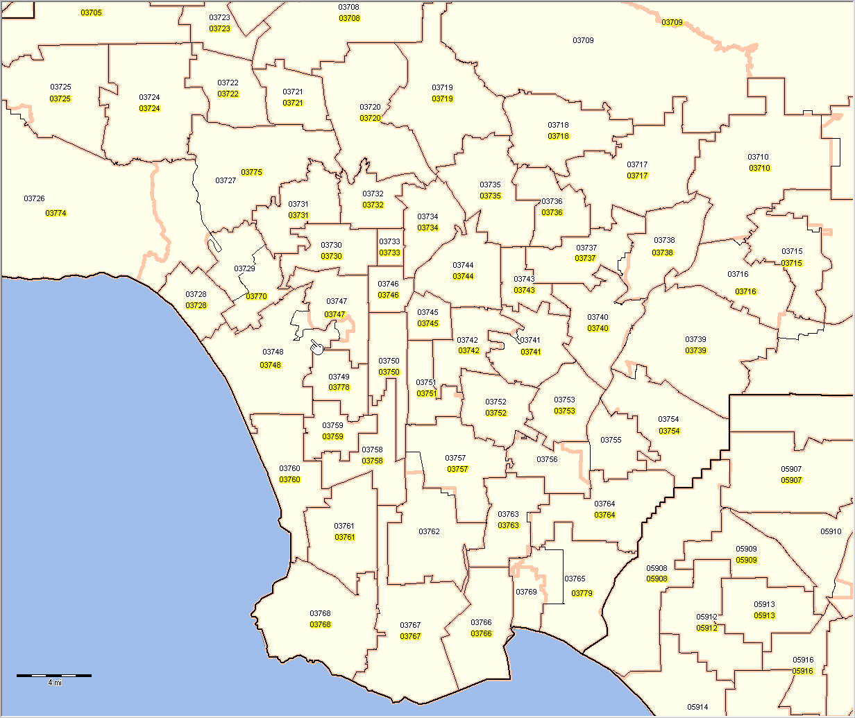
PUMA Vintages ACS 5-year PUMS files are released annually. The ACS 2020 5-year PUMS files use the 2010 vintage PUMAs. The 2010 PUMAs apply generally throughout the 2010s. The ACS 2016 PUMS files were the first to use all 2010 PUMAs for each year of the PUMS data. The ACS 2020 PUMS data (release date March 31, 2022) use the 2010 vintage PUMAs. As will the ACS 2021 PUMS data (early 2023). The 2020 vintage PUMAs (boundaries, codes, names) are expected to be completed in mid-2022. These geographies are expected to be included in TIGER line files released in 2023. The 2020 PUMAs will be used with the ACS 2022 PUMS files (released early 2024). PUMS Data are Estimated for PUMAs; Using VDA Web GIS The following graphic illustrates how you can use VDA Web GIS to view Public Use Microdata Areas (PUMAs) contextually relative to topography or other geostatistical data. The static map views in the scoll section at right are essentially obsoleted with availability of VDA Web GIS. In the following example the Find Address feature is used to zoom to downtown Los Angeles and show PUMA boundaries and codes. An arbitrary PUMA is clicked to show the demographic profile for that PUMA (crosshatched). This view illustrates using the VDA Table where each row corresponds to a PUMA. In this example, total population and median household income are displayed as selected columns; the table is sorted in descending order on median household income. 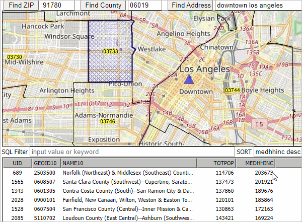
Topics • Detailed PUMA 2010 maps ... scroll section at right • PUMA Summary Statistic Demographics (below) • PUMA-County-Place-Tract Geo Equivalence Table (below) • PUMS Microdata for PUMAs (below) • Details about PUMAs (below) • ACS 2017 1-Year PUMS Data by PUMA • ACS 2017 5-Year PUMS Data by PUMA Public Use Microdata Areas .. Census 2010 PUMAa PUMAs shown with black boundary in context of counties. Click graphic for larger view showing PUMAs as markers (based on internal PUMA point). Expand browser to full screen for best quality view. 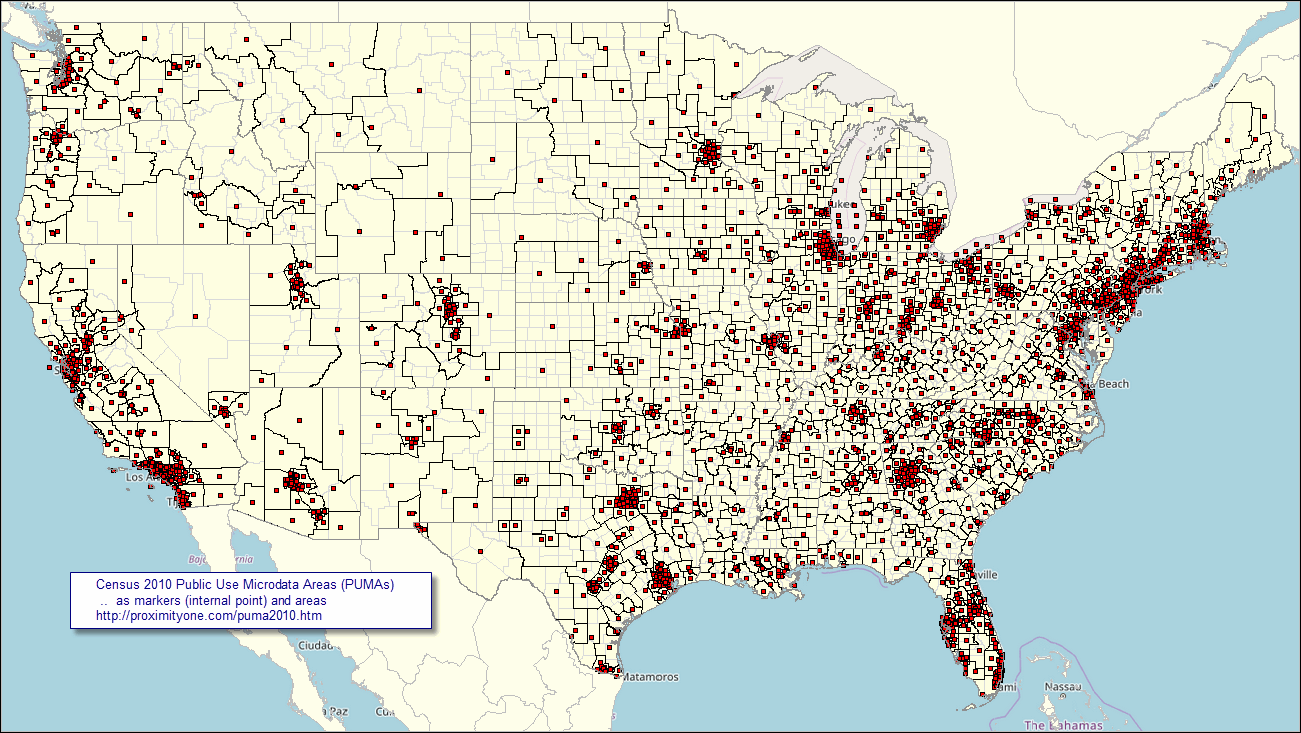 View created with CV XE GIS. Click graphic for larger view with more detail. Public Use Microdata Areas as Markers .. based on internal PUMA point PUMAs shown with black boundary in context of counties. Click graphic for larger view showing PUMAs as markers (based on internal PUMA point). Expand browser to full screen for best quality view. View created with CV XE GIS. Click graphic for larger view with more detail. Patterns of Median Household Income by Census Tract .. in context of PUMAs Integrating census tract geography with PUMAs; relating multi-sourced statistical data .. illustrating applications in the Los Angeles area .. select any area using GIS tools and project. Census tract thematic pattern using ACS 2016 estimates in context of PUMAs labeled with percent population 25 years and over with bachelor's degree. Click graphic for larger view showing PUMAs as markers (based on internal PUMA point). Expand browser to full screen for best quality view. 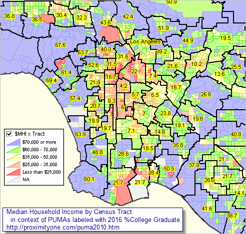 View created with CV XE GIS. Click graphic for larger view with more detail. See links to detailed PUMA 2010 maps ... scroll section at right. PUMA Summary Statistic Data .. goto top 2010 vintage PUMA summary statistic data, based on the ACS 2012 1-year estimates, may be accessed via these interactive tables: • General Demographics • Social Characteristics • Economic Characteristics • Housing Characteristics PUMS Microdata for PUMAs .. goto top Public Use Microdata Sample (PUMS) files provide a way to develop custom estimates of demographic summary statistics for PUMAs, states and the U.S. The American Community Survey (ACS) PUMS files are comprised of samples of individual respondent person and housing unit records. The ACS PUMS files are released annually providing a means to develop similar custom estimates with annual updates. • ACS 2017 1-Year PUMS Data by PUMA • ACS 2017 5-Year PUMS Data by PUMA 2010 Vintage PUMA Geography The 2,378 2010 vintage PUMAs are developed using Census 2010 geography, cover the U.S. wall-to-wall, conform to state boundaries, and where possible are comprised of whole Census 2010 census tracts. The first use of the 2010 vintage PUMAs is with the ACS 2012 PUMS and 1-year summary statistic data. Use the interactive table in this section to examine 2010 PUMAs and PUMA component area geography. While PUMS files contain data for respondents across the U.S., most lower level geography are not identified by any variables in the PUMS files. The PUMA is the most detailed unit of geography identified in the PUMS files. PUMAs are special non-overlapping areas that partition each state into contiguous geographic units containing no fewer than 100,000 people each. 2010 PUMAs were built on census tracts, and cover the entirety of the United States and Puerto Rico. Mapping PUMAs What are the PUMA boundaries? How do they relate to other geography? Use the CV XE GeoGateway to view PUMA shapefiles. Zoom into one or a set of PUMAs. Overlay county or other geography. Integrate your PUMS summary statistic estimates into the PUMA shapefiles; display thematic pattern maps of the custom estimates. See New York PUMA applications and more detailed Arizona by PUMA views. Public Use Microdata Area PUMA 2010 Vintage Geography -- interactive table .. goto top There is one row for each PUMA and PUMA component area. Table may require a minute to populate. Click column header to sort; click again to sort other direction. See related interactive tables main page Table Notes and Usage Columns: • SumLev - geographic summary level code (select below table) • State - state FIPS code • PUMA - PUMA code -- unique within state • County - county FIPS code • CCD - county subdivision code • Place - place code • Population - Census 2010 population • Hsg Units - Census 2010 housing units • Name - PUMA name or PUMA component area name Operations: • Click ShowAll button between queries. • To view the list of all PUMAs (PUMA summary level 795 only): - click ShowAll button. - optionally select a state (left dropdown below table). - click SummaryLevel selector below table and choose 795; table refreshes. - you can confirm there are 2,378 PUMAs in the U.S. > estimate custom summary statistics for any one/all of these areas using PUMS data using CV XE Crosstabs. - optionally rank on population (or other column) -- dbl-click header cell. - you can confirm the Census 2010 population of the smallest population PUMA is 100,020. - you can confirm the Census 2010 population of the largest population PUMA is 268,718. • To view the list of all cities/places: - click ShowAll button. - optionally select a state (left dropdown below table). - click SummaryLevel selector below table and choose 798; table refreshes. - optionally rank on population (or other column) -- dbl-click header cell. • To view the list of all components by area name: - click ShowAll button. - key-in case sensitive partial/whole name in text box to right of Find in Name button. - click Find in Name button. Table refreshes. - default shows NYC for New York City; other examples: Los Angeles County. - optionally rank on population (or other column) -- dbl-click header cell. Support Using these Resources .. goto top Learn more about accessing and using demographic-economic data and related analytical tools. Join us in a Data Analytics Lab session. There is no fee for these one-hour Web sessions. Each informal session is focused on a specific topic. The open structure also provides for Q&A and discussion of application issues of interest to participants. ProximityOne User Group Join the ProximityOne User Group to keep up-to-date with new developments relating to metros and component geography decision-making information resources. Receive updates and access to tools and resources available only to members. Use this form to join the User Group. Additional Information ProximityOne develops geodemographic-economic data and analytical tools and helps organizations knit together and use diverse data in a decision-making and analytical framework. We develop custom demographic/economic estimates and projections, develop geographic and geocoded address files, and assist with impact and geospatial analyses. Wide-ranging organizations use our tools (software, data, methodologies) to analyze their own data integrated with other data. Follow ProximityOne on Twitter at www.twitter.com/proximityone. Contact us (888-364-7656) with questions about data covered in this section or to discuss custom estimates, projections or analyses for your areas of interest. |
|
|