
|
|
|
-- 5-Year Public Use Microdata Sample (PUMS) data & analytics .. the ACS 2017 PUMS 5-year microdata are available for use on January 17, 2019. There are several important uses for Public Use Microdata Sample (PUMS) files. Perhaps the most important feature is that PUMS files enable development of summary statistics for custom-defined subject matter, or crosstabs. Only a relatively small number of preplanned summary statistics are tabulated from statistical surveys such as ACS 2017. For ACS 2017, the files contain the full range of population and housing unit responses collected on the questionnaire for a subsample of ACS respondents. See list of items below. • Person Record Items (XLS) • Housing Record Items (XLS) • This section is updated periodically. Register to receive updates. • About ACS • About ACS 2017 .. products and release dates Patterns of Economic Prosperity by Census Tract .. in context of PUMAs PUMAs -- Public Use Microdata Areas -- are 2,378 geographic areas covering the U.S. wall-to-wall that are the primary geography for which PUMS estimates may be produced. PUMAs, shown with black boundaries in the following view, must have at least 100,000 population as of Census 2010. This view illustrates census tract geodemographics/patterns of economic prosperity (median household income) shown in context of PUMAs in the Los Angeles area. PUMAa are labeled with percent population ages 25 and over who are high school graduates. 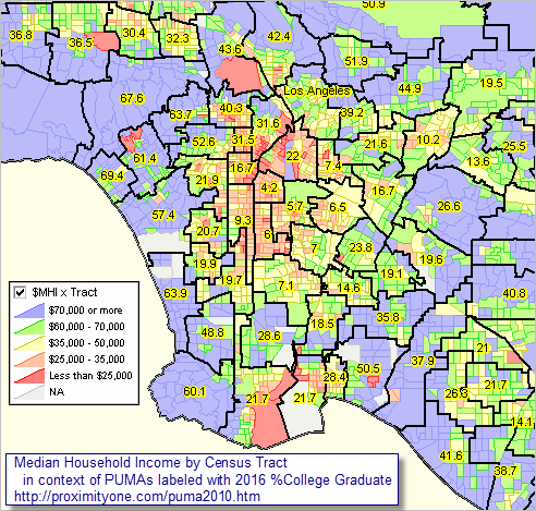 View created with CV XE GIS. Click graphic for larger view with more detail. A second important use of PUMS data is the ability to examine characteristics of individual persons or households that are identified as meeting some feature, like employed persons, or households having an income range different from those available from preplanned summary statistics. Micro-modeling is the study of patterns among some group of geographically or demographically specified group. PUMS data enable microdata analysis not possible with summary statistic data. To preserve confidentiality, PUMS data do not contain personal identifiers such as name or address. ACS PUMS Geography .. goto top The low level geography for which PUMS estimates can be developed are the Public Use Microdata Areas (PUMA). PUMAs, generally comprised of a set of continuous census tracts, have a population of 100,000 or more. The 2,378 PUMAs cover the U.S. wall-to-wall and are static geographic areas through the 2010s. Larger population counties are often comprised of many PUMAs. Los Angeles county has 69 PUMAs. ACS PUMS Data Files .. goto top ACS PUMS files are organized as person files and household files. Each record in the PUMS person file corresponds to an individual person (respondent). Each record in the PUMS household file corresponds to a single housing unit/household (for respondent). In the person-level file, individuals are organized into households, making possible the study of people within the contexts of their families and other household members. 1-year PUMS files, such as 2017, contain data on approximately one percent of the U.S. population. 5-year PUMS files, covering a five-year period, such as 2013-2017, contain data on approximately five percent of the U.S. population. Create Your Own ACS PUMS Custom Demographic Estimates .. goto top Use the CV XE Crosstabs tool to develop custom demographic estimates using the PUMS data for PUMAs, states and the U.S. Save the custom estimates data to file and optionally integrate those data into a PUMA or state shapefile for mapping and pattern analysis using the CV XE GIS software. Related Sections • 2010 Public Use Microdata Areas (PUMAs) ... geographic areas identified in the PUMS data files • Public Use Microdata Sample (PUMS) Files • PUMA Summary Statistic Data ... 2010 vintage PUMA summary statistic data, based on the ACS 2012 1-year estimates access via these interactive tables: - General Demographics - Social Characteristics - Economic Characteristics - Housing Characteristics ACS PUMS Documentation .. goto top ACS 2016 PUMS ReadMe • 2012-2016 ACS 5-year PUMS ReadMe pdf • 22016 ACS 1-year PUMS ReadMe pdf Subjects in the PUMS A list of topics included in each of the housing and population record files • 2012-2016 ACS 5-year PUMS Subjects pdf • 2016 ACS 1-year PUMS Subjects pdf PUMS Data Dictionary Includes variables available for each PUMS release and how each variable is coded • 2012-2016 ACS 5-year PUMS Data Dictionary pdf • 2012-2016 ACS 5-year PUMS Data Dictionary txt • 2016 ACS 1-year PUMS Data Dictionary pdf • 2016 ACS 1-year PUMS Data Dictionary txt PUMS Top Coded and Bottom Coded Values List of variables with responses exceeding a state-specific value that are replaced with a predetermined value • 2016 ACS PUMS Top & Bottom Coded Variables PDF • 2016 ACS PUMS Top & Bottom Coded Values CSV PUMS Estimates for User Verification • 2012-2016 ACS 5-year PUMS estimates SAS • 2012-2016 ACS 5-year PUMS estimates LST • 2012-2016 ACS 5-year PUMS estimates CSV • 2016 ACS 1-year PUMS estimates SAS • 2016 ACS 1-year PUMS estimates LST • 2016 ACS 1-year PUMS estimates CSV ProximityOne User Group .. goto top Join the ProximityOne User Group to keep up-to-date with new developments relating to metros and component geography decision-making information resources. Receive updates and access to tools and resources available only to members. Use this form to join the User Group. Support Using these Resources Learn more about accessing and using demographic-economic data and related analytical tools. Join us in a Data Analytics Lab session. There is no fee for these one-hour Web sessions. Each informal session is focused on a specific topic. The open structure also provides for Q&A and discussion of application issues of interest to participants. Additional Information ProximityOne develops geodemographic-economic data and analytical tools and helps organizations knit together and use diverse data in a decision-making and analytical framework. We develop custom demographic/economic estimates and projections, develop geographic and geocoded address files, and assist with impact and geospatial analyses. Wide-ranging organizations use our tools (software, data, methodologies) to analyze their own data integrated with other data. Follow ProximityOne on Twitter at www.twitter.com/proximityone. Contact us (888-364-7656) with questions about data covered in this section or to discuss custom estimates, projections or analyses for your areas of interest. |
|
|