
|
|
|
-- ACS 2020 5-year Public Use Microdata Sample (PUMS) -- custom demographic-economic estimates modeling for PUMAs -- annually updated; focus here on using data released March 31, 2022 April 2022 .. Public Use Microdata Samples (PUMS) are data files that contain a sample of individual respondent data from a statistical survey or census for a Public Use Microdata Area (PUMA). PUMAs, covering the U.S. wall-to-wall, have a minimum of 100,000 population to avoid the possibility of revealing confidential respondent data. See about PUMA vintages. This section is focused on the ACS 2016-20 5-year PUMS. Patterns of Ability to Speak English The graphic below shows patterns of the population by ability to speak English by PUMA in the southern California area. Inset legend shows color intervals of the population speaking English "Not Well" and "Not at all" as a percent of total population by PUMA. The custom estimates were developed using the ACS 2016-2020 5-year PUMS data. 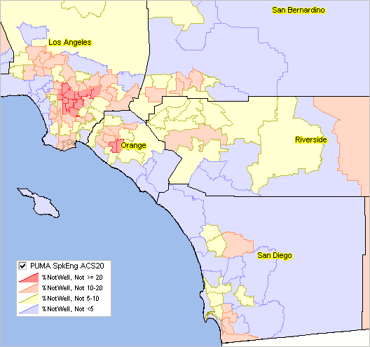
The above graphic was developed in the following steps: • the California ACS 2020 5-year persons PUMS file was downloaded. .. from this FTP site .. the file unix_pca.zip and unzipped to a local folder. • the unzipped file (a SAS data file) was converted to a dBase structure. • the CA dBase PUMS person file was opened with the ProximityOne Microdata Analyst (MDA) software. .. MDA is a Windows-based crosstab software developed to process PUMS files. .. an important feature of MDA is that it generates dBase file ready to integrate into a shapefile. for use in GIS applications. .. MDA generates output/summary statistics in a grid .. see example .. in above graphic view, the estimated total population in PUMA 0600101 is 143,365 .. each row corresponds to a PUMA; MDA run s all PUMAs in a state as a batch operation. .. each column corrresponds to a "query statement" as shown below. • in the same run, the MDA "query file" was opened with MDA. .. the query file sets the specification or the summary fields to be developed. .. *P generates the total population estimate. .. the second query statement estimates the number of persons where "ENG" in the data dictionary has value " ". .. the PUMS variable "ENG" is shown on page 33 in the data dictionary.
*P TotPop #Total Population
• MDA processing is started and generates a summary file for all PUMAs in that state.(ENG=" ") *P ENGNA #ENGNA (ENG="1") *P ENGVwell #ENGVwell (ENG="2") *P ENGWell #ENGWell (ENG="3") *P ENGNwell #ENGNwell (ENG="4") *P ENGNot #ENGNot (HISP<>"01") .and. (ENG=" ") *P hENGNA #hENGNA (HISP<>"01") .and. (ENG="1") *P hENGVwell #hENGVwell (HISP<>"01") .and. (ENG="2") *P hENGWell #hENGWell (HISP<>"01") .and. (ENG="3") *P hENGNwell #hENGNwell (HISP<>"01") .and. (ENG="4") *P hENGNot #hENGNot .. summary column the query file sets the specification or the summary fields to be developed. About ACS. Essential data to assess where we are, how things have changed and how things might change in the future down to the sub-neighborhood level. The American Community Survey (ACS) is a nationwide survey designed to provide annually updated demographic-economic data for national and sub-national geography. ACS provides a wide range of important data about people and housing for every community across the nation. The results are used by everyone from planners to retailers to homebuilders and issue stakeholders like you. ACS is a primary source of local data for most of the 40 topics it covers, such as income, education, occupation, language and housing. PUMS Data are Estimated for PUMAs; Using VDA Web GIS The following graphic illustrates how you can use VDA Web GIS to view Public Use Microdata Areas (PUMAs) contextually relative to topography or other geostatistical data. In this example the Find Address feature is used to zoom to downtown Los Angeles and show PUMA boundaries and codes. An arbitrary PUMA is clicked to show the demographic profile for that PUMA (crosshatched). This view illustrates using the VDA Table where each row corresponds to a PUMA. In this example, total population and median household income are displayed as selected columns; the table is sorted in descending order on median household income. 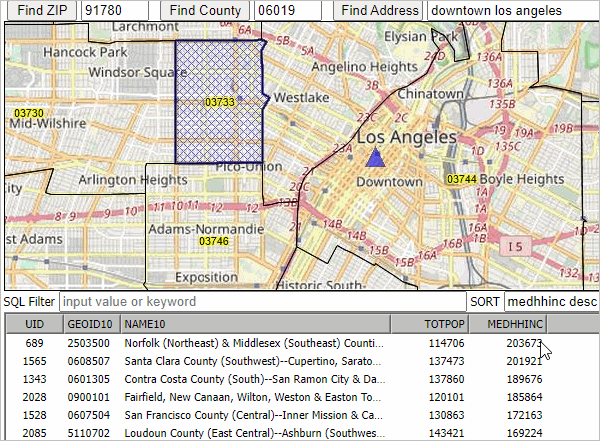
ACS 2020 Data Resources ... goto top • ACS 2020 Main • ACS 5-year estimates .. release date: March 17, 2022 .. estimates for all areas down to block group level • ACS 5-year PUMS data.. focus of this section .. release date: March 31, 2022 .. microdata data for custom estimates and individual modeling This section is focused on ACS 2020 data access, integration and use. Updated periodically, this section provides illustrative applcations using these data. Register to receive updates. ACS Public Use Microdata Sample (PUMS) Public Use Microdata Sample (PUMS) files are datasets that contain a sample of individual respondent data for statistical surveys. For ACS 2020, the files contain the full range of population and housing unit responses collected on individual ACS questionnaires, for a subsample of ACS housing units and group quarters persons. PUMA Vintages ACS 5-year PUMS files are released annually. The ACS 2020 5-year PUMS files use the 2010 vintage PUMAs. The 2010 PUMAs apply generally throughout the 2010s. The ACS 2016 PUMS files were the first to use all 2010 PUMAs for each year of the PUMS data. The ACS 2020 PUMS file (release date March 31, 2022) uses the 2010 vintage PUMAs. As will the ACS 2021 PUMS data (early 2023). The 2020 vintage PUMAs (boundaries, codes, names) are expected to be completed in mid-2022. These geographies are expected to be included in TIGER line files released in 2023. The 2020 PUMAs will be used with the ACS 2022 PUMS files (released early 2024). ACS 2020 5-Year PUMS Reference/Resources .. goto top • General Reference • ACS 2016-2020 5-Year PUMS File ReadMe • Access/Download via FTP Developing/Using PUMS Estimates for PUMAs PUMS based summary statistics (crosstabs) have to be developed by specialized software. ProximityOne has developed the MicroDataAnalyst to perfrom these operations. MicroDataAnlyst operates on a Windows computer to process a wide range of microdata files including the Census 2010 PUMS, ACS 1-year and 5-year annual PUMS and others. Alternatively, use ProximityOne services to have custom estimates developed. Call (888.364.7656) or e-mail us for more information. Examining Language Spoken at Home; An Example Languange Spoken At Home (LSAH) is one of many subject topics that could be examined. There is a hypothetical analysis where an objective is to view the spatial distribution by PUMA of the percent Hispanic population who speak language "not well" or "not at all". The following graphic shows a thematic pattern map of economic prosperity (median hosuehold income) by neighborhood/census tract for the Orange County, CA (black boundary) area. It is one end point in the analysis. PUMAs are shown by red boundaries; in each PUMA: - PUMA upper label shows total population for that PUMA - PUMA lower label shows percent total population who are Hispanic and (do not speak English very well + do not speak English at all) Click graphic for larger view; expand browser to full window for best quality view. The larger view shows a profile for the PUMA located at the pointer in the map. 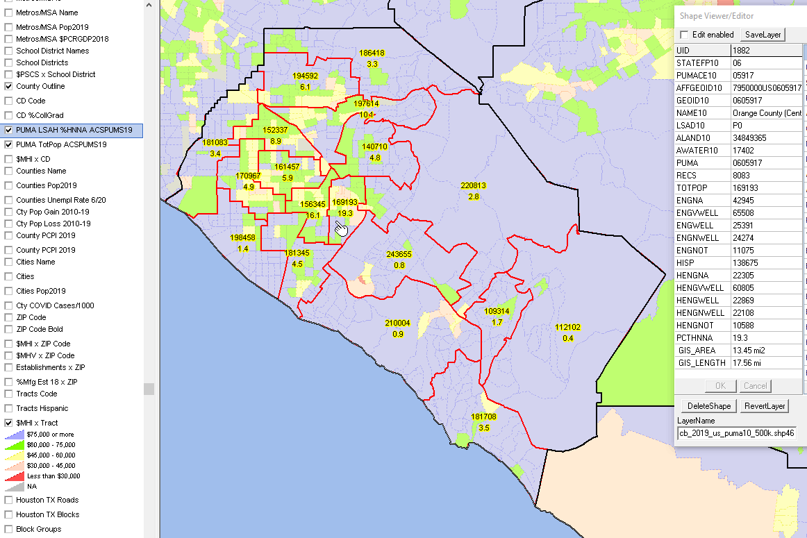 .. map view developed using ProximityOne CV XE GIS software .. crosstabs/estimates developed using ProximityOne MicroDataAnalyst software Tabular Profile for PUMA 0605917 The following table shows the same scope of data as displayed in the above graphic mini profile for this PUMA.
The query used to compute the items is shown below. There is one "instruction line" for each item computed. These lines are rows in a text file that is input to MicroDataAnalyst which computes and generates. *P TotPop #Total Population (ENG=" ") *P ENGNA #ENGNA (ENG="1") *P ENGVwell #ENGVwell (ENG="2") *P ENGWell #ENGWell (ENG="3") *P ENGNwell #ENGNwell (ENG="4") *P ENGNot #ENGNot (HISP<>"01") .and. (ENG=" ") *P hENGNA #hENGNA (HISP<>"01") .and. (ENG="1") *P hENGVwell #hENGVwell (HISP<>"01") .and. (ENG="2") *P hENGWell #hENGWell (HISP<>"01") .and. (ENG="3") *P hENGNwell #hENGNwell (HISP<>"01") .and. (ENG="4") *P hENGNot #hENGNot The resulting estimates data are then merged into the PUMA shapefile to develop the map view shown above. Scope & Organization of Subject Matter PUMS files enable the development of custom estimates/analyses for subject matter not published as summary statistics based on a sample of actual ACS responses. See the scope of subject matter in the ACS1519 5-year PUMS data dictionary. The low level geography for which PUMS estimates can be developed is the Public Use Microdata Areas (PUMA). PUMAs, generally comprised of a set of continuous census tracts, have a population of 100,000 or more. The 2,378 PUMAs cover the U.S. wall-to-wall and are static geographic areas through the 2010s. Larger population counties are often comprised of many PUMAs. Los Angeles county has 69 PUMAs. PUMS files also enable microdata analysis not possible with summary statistic data. Each record in the PUMS file represents a single person (person file) or a single housing unit (household file). In the person-level file, individuals are organized into households, making possible the study of people within the contexts of their families and other household members. 1-year PUMS files, such as 2019, contain data on approximately one percent of the U.S. population. 5-year PUMS files, covering a five-year period, such as 2015-2019, contain data on approximately five percent of the U.S. population. Accessing PUMA Data Preplanned Data ACS preplanned summary data are available for PUMAs much in the same ways as for states. Table universe: Hispanic or Latino Population 5 Years and Over Columns in this table Total: Speak only English Speak Spanish: Speak English "very well" Speak English "well" Speak English "not well" Speak English "not at all" Speak other language Using ACS Data; ACS 1-Year versus ACS 5-Year Data .. top While ACS 1-year estimates are suitable for time-series analyses, the ACS 5-year estimates are not the same as annual demographic-economic estimates and may not be suitable for annual time series analyses. Advantages of using the 5-year estimates • the data are available for all census tracts and ZIP code areas. • the data are available for all cities/places, counties and school districts irrespective of size. Disadvantages of using the 5-year estimates • the data are older than the 1-year estimates. • the data are for a 5-year period rather than one year. • additional cautions in comparing estimates over time (see below). Advantages of using the 1-year estimates • the data are more recent than the 5-year estimates. • the data are generally more accurate than the 5-year estimates. Disadvantages of using the 5-year estimates • the data are not available for census tracts and ZIP code areas. • the data are available for only areas of 65,000 population and over. • the margin of error (MOE) of the estimate is normally larger that for the 5-year estimates. Additional cautions in comparing estimates over time • ACS 2012 5 year estimates are based on survey respondent data for the years 2008 through 2012. • ACS 2013 5 year estimates are based on survey respondent data for the years 2009 through 2013. • ACS 2014 5 year estimates are based on survey respondent data for the years 2010 through 2014. • ACS 2015 5 year estimates are based on survey respondent data for the years 2011 through 2015. • ACS 2016 5 year estimates are based on survey respondent data for the years 2012 through 2016. • ACS 2017 5 year estimates are based on survey respondent data for the years 2013 through 2017. • ACS 2018 5 year estimates are based on survey respondent data for the years 2014 through 2018. • The ACS 2012 5 year data & ACS 2013 5 year data are based on the same respondent data for the four years 2009 through 2012. • The ACS 2013 5 year estimates drop 2008 respondents and add 2013 respondents. • The ACS 2014 5 year estimates drop 2009 respondents and add 2014 respondents. • The ACS 2015 5 year estimates drop 2010 respondents and add 2015 respondents. • The ACS 2016 5 year estimates drop 2011 respondents and add 2016 respondents. • The ACS 2017 5 year estimates drop 2012 respondents and add 2017 respondents. • The ACS 2018 5 year estimates drop 2013 respondents and add 2018 respondents. • While 5-year estimates are independently developed annually, they include demographic-economic characteristics for some of the same respondents. Other considerations • Are the needed subject matter available from Census 2010? - ACS more detailed demographic-economic data (like income) may not be a plus. • Census 2010 provides more accurate data than ACS estimates. • Often there are more detailed age (and other) breakouts for subject matter in Census 2010 compared to ACS. • The most recent ACS-sourced small area data are from ACS 2017 (December 2018) 5-year estimates; - ACS 2017 5-year estimates are centric to 2015. Areas Published ... goto top ... this general description will be updated with specific ACS 2018 geography soon. ... availability of summary statistic data by type of geography ... link in left column provide access to related interactive tables for specific geographic level.
Notes ... 1 County equivalents include Alaska boroughs, municipalities, city and boroughs, and census areas; Louisiana parishes; Puerto Rico municipios; independent cities in Maryland, Missouri, Nevada, and Virginia. 2 For 1-year estimates, qualifying Minor Civil Divisions in 20 states only. For 5-year estimates, all county subdivisions. 3 1-year estimates are not produced for this geographic level, regardless of population size. 4 All metropolitan statistical areas receive ACS 1-year estimates. A population minimum of 50,000 is applied instead of the standard 65,000. 5 Legislative session year 2016. * Counts based on geographic area boundaries as of January 1, 2017. ** ACS data are not available for census blocks. ProximityOne User Group ... goto top Join the ProximityOne User Group to keep up-to-date with new developments relating to metros and component geography decision-making information resources. Receive updates and access to tools and resources available only to members. Use this form to join the User Group. Support Using these Resources Learn more about accessing and using demographic-economic data and related analytical tools. Join us in a Data Analytics Lab session. There is no fee for these one-hour Web sessions. Each informal session is focused on a specific topic. The open structure also provides for Q&A and discussion of application issues of interest to participants. Additional Information ProximityOne develops geodemographic-economic data and analytical tools and helps organizations knit together and use diverse data in a decision-making and analytical framework. We develop custom demographic/economic estimates and projections, develop geographic and geocoded address files, and assist with impact and geospatial analyses. Wide-ranging organizations use our tools (software, data, methodologies) to analyze their own data integrated with other data. Follow ProximityOne on Twitter at www.twitter.com/proximityone. Contact us (888-364-7656) with questions about data covered in this section or to discuss custom estimates, projections or analyses for your areas of interest. | ||||||||||||||||||||||||||||||||||||||||||||||||||||||||||||||||||||||||||||||||||||||||||||||||||||||||||||||||||||||||||||||||||||||||||||||||||||||||||||||||||||||||||||||||||||||||||||||||||||||||||||||||||||||||||||||||||||||||||||||||||||||||||||||||||||||||||||||||||||||||||||||||||||||||||||||||||||||||
|
|