
|
|
|
-- ACS 2020 5-year estimates -- annually updated demographic-economic data to the block group level March 2022 .. essential data to assess where we are, how things have changed and how things might change in the future down to the sub-neighborhood level. The American Community Survey (ACS) is a nationwide survey designed to provide annually updated demographic-economic data for national and sub-national geography. ACS provides a wide range of important data about people and housing for every community across the nation. The results are used by everyone from planners to retailers to homebuilders and issue stakeholders like you. ACS is a primary source of local data for most of the 40 topics it covers, such as income, education, occupation, language and housing. ACS 2020 Data Resources ... goto top • ACS 2020 Main • ACS 5-year estimates .. focus of this section .. release date: March 17, 2022 .. estimates for all areas down to block group level • ACS 5-year PUMS data .. release date: March 31, 2022 .. microdata data for custom estimates and individual modeling This section is focused on ACS 2020 data access, integration and use. Updated periodically, this section provides illustrative applcations using these data. Register to receive updates. • See detailed scope of ACS subject matter available below. • See details below on using ACS: access, analyze, integrate data. • Demographic Economic Data Explorer (DEDE) .. create your own custom datasets and reports. • Mapping & GIS solutions using: .. CV XE GIS .. Windows desktop .. VDA Web GIS .. only browser required; nothing to install • Use this API Link to get the ACS 2020 population for all ZIP Code areas. .. an example .. clicking the above link displays a "CSV-looking" return page. .. each row shows the population, then the state code, then the ZIP code. • Get custom, ready-to-use files. E-mail us or call 800.364.7656 to review options/needs. Next are a series of thematic pattern maps and tabular data profiles that illustrate how these data can be used. Census tract geography are used but presentations can be for wide-ranging geographic areas (summary levels) as listed in the areas published table shown below. Using the ACS 5-year Estimates ... goto top patterns of economic prosperity by neighborhood; census tract The following graphic shows patterns of ACS 5-year estimates of median family income by census tract. Colors assigned to income intervals are shown in the inset legend. This view illustrates use of just one subject matter item for one type of geography. Click graphic for larger view. Expand browser window to full screen for best quality view. Larger view illustrates how CBSAs/MSAs can be shown contextually. 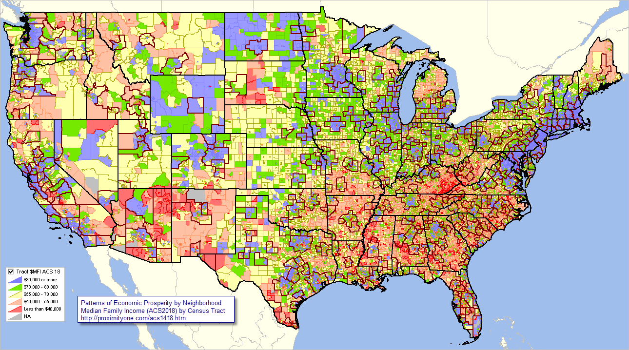 .. view created with ProximityOne CV XE GIS software and related GIS project. The above map provides many insights. Patterns and insights are immediately consumable in a collaborative setting or published document. Zoom-in View, Adding County Boundaries ... goto top patterns of economic prosperity by neighborhood; census tract Similar to the above view, the following graphic shows patterns of ACS 5-year estimates of median family income by census tract with zoom-in to midwest. Colors assigned to income intervals are shown in the inset legend. Click graphic for larger view. Expand browser window to full screen for best quality view. Larger view illustrates how CBSAs/MSAs can be shown contextually. 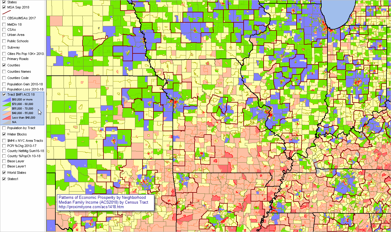 .. view created with ProximityOne CV XE GIS software and related GIS project. Add your own data. Use different subject matter for geospatial analysis. Mathematically combine ACS subject matter items. Choose your own labels. Set display criteria to meet your needs. ACS 2020 Detailed Summary File Table/Item Metadata ... goto top Use this table to examine/select detailed demographic-economic attributes. See more generally about these data at top of section. Click ShowAll button between Find/Queries. Click column header cell to sort table on that column; click again to sort other direction. Use mouseover on column header to view column description. See usage notes below table. See related interactive tables. Usage Notes The ACS Summary File, released annually and including separate 1-year and 5-year estimates (shown in far right column in above table) is comprised of table-item sets, Table numbers are shown in the left-most column in the above interactive table. A "C" table generally includes more aggregative items than a corresonding "B" table. Following the B/C character in the table number is a 2-digit subject matter code as shown in the list below. ACS table-items sets are comprised of one or more items. Items within a table are enumerated by the sequence code shown in column two of the above table. Column 3 in the above table shows the combined unique table-item code. This column is also used as the field name for the items when accessing and using the data. Column 4 in the above table show the table name, tabulation universe or item description. It is important to combine the description of the item with the table name and the universe for which the data have been tabulated. Subject Matter Codes - 01 Age - 02 Race - 03 Hispanic Origin - 04 Ancestry - 05 Foreign Born; Citizenship; Year or Entry; Nativity - 06 Place of Birth - 07 Residence 1 Year Ago; Migration - 08 Journey to Work; Workers Characteristics; Commuting - 09 Children; Household Relationship - 10 Grandparents; Grandchildren - 11 Household Type; Family Type; Subfamilies - 12 Marital Status and History - 13 Fertility - 14 School Enrollment - 15 Educational Attainment - 16 Language Spoken at Home and Ability to Speak English - 17 Poverty - 18 Disability - 19 Income (Households and Families) - 20 Earnings (Individuals) - 21 Veteran Status - 22 Transfer Programs (Public Assistance) - 23 Employment Status; Work Experience; Labor Force - 24 Industry; Occupation; Class of Worker - 25 Housing Characteristics - 26 Group Quarters - 27 Health Insurance - 28 Computer and Internet Use - 29 Citizen Voting-age Population Race and Hispanic Origin Many tables are provided in multiple racial tabulations. If a table code ends in a letter from A-I, that code indicates that the table universe is restricted to a subset based on responses to the race or Hispanic/Latino-origin questions. : - A White alone - B Black or African American Alone - C American Indian and Alaska Native Alone - D Asian Alone - E Native Hawaiian and Other Pacific Islander Alone - F Some Other Race Alone - G Two or More Races - H White Alone, Not Hispanic or Latino - I Hispanic or Latino Developing Extract Subject Matter Lists ... goto top The following process assumes that you are using a Windows computer to develop an subject matter extract file for use with the CV XE GIS software. To create a subject matter extract file check the checkbox in each table/item row of interest. .. the row turns blue indicating it has been selected. .. select all or a few items from any table. .. .. do not select the table name or universe row. .. with all selections complete, right-click on any blue selected item and copy-to-clipboard. .. these rows may now be pasted into a text file or Excel Example: .. open the web page http://proximityone.com/acs1519.htm#table .. click the "Find Table" button below the table this searches the populated table for all occurences of "B19101H" (the default value) the user would need to know in advance they are looking for this table number. Table B19101H provides date items for FAMILY INCOME IN THE PAST 12 MONTHS ... (WHITE ALONE, NOT HISPANIC OR LATINO HOUSEHOLDER) with a tabulation universe of Families with a householder who is White alone, not Hispanic or Latino 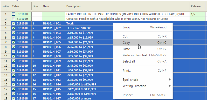 Next, open a text editor, like Notepad, and CTRL-V paste into the open form: 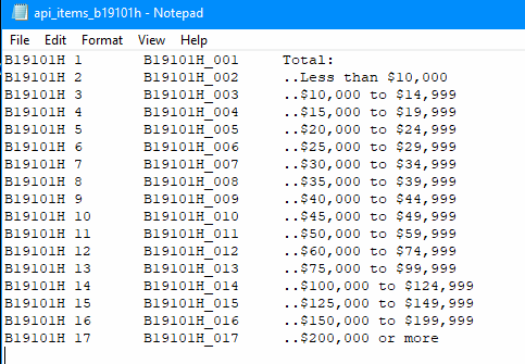 It is recommended that this subject matter file be saved in the c:\cvxe\1 folder. To retrieve the data, start CV XE GIS and use the File>APIGateway feature. In the most basic use, open the text file just created as the Subject Matter file to be used. Further Drill-down; Houston, TX inner beltway area ... goto top patterns of economic prosperity by neighborhood; census tract Similar to the above view, the following graphic shows patterns of ACS 2018 5-year estimates of median family income ($MFI) by census tract with zoom-in to Houston, TX inner beltway area. Colors assigned to income intervals are shown in the inset legend. Tracts are labeled with $MFI. Click graphic for larger view. Expand browser window to full screen for best quality view. Larger view shows tracts labeled with $MFI (yellow label) and the census tract code (white label). Some tracts show the top coded value of $250,001, indicating the value is $250,000 or more. In this view, all tracts are within Harris County, TX (48201) so the 6 character tract code uniquely identifies the tract.  .. view created with ProximityOne CV XE GIS software and related GIS project. Tip of the Iceberg; Illustrating More Detailed Data in Profile/Tabular Form ... goto top Toward the center of the larger map shown for the Houston drill-down, above, note the two adjacent higher and lower $MFI tracts (100000 and 410100, or sometimes shown as 1000.00 and 4191.00). The $MFI values are item E086 shown in the economic profiles for these tracts accessed by clicking the links below. Using these organized profiles, it is easy to view related attributes of these tracts and how they are similar or different. Even with the approximate 522 subject matter items for the profiles, this set of subject matter items remains the "tip of the iceberg". More detailed data contained in tables (see table shells) further down in this section. Tract 48-201-100000 General Demographics .. Social Characteristics .. Economic Characteristics .. Housing Characteristics Tract 48-201-410100 General Demographics .. Social Characteristics .. Economic Characteristics .. Housing Characteristics Reference .. go top • ACS 2018 Questionnaire • Summary File Technical Documentation • ACS 2018 Tables Shells • ACS 2018 5-year Sequence Table Lookup • ACS 2018 5-Year Appendices • ACS 2018 5-Year Appendices BG -- tables available by BG Using ACS Data; ACS 1-Year versus ACS 5-Year Data .. top While ACS 1-year estimates are suitable for time-series analyses, the ACS 5-year estimates are not the same as annual demographic-economic estimates and may not be suitable for annual time series analyses. Advantages of using the 5-year estimates • the data are available for all census tracts and ZIP code areas. • the data are available for all cities/places, counties and school districts irrespective of size. Disadvantages of using the 5-year estimates • the data are older than the 1-year estimates. • the data are for a 5-year period rather than one year. • additional cautions in comparing estimates over time (see below). Advantages of using the 1-year estimates • the data are more recent than the 5-year estimates. • the data are generally more accurate than the 5-year estimates. Disadvantages of using the 5-year estimates • the data are not available for census tracts and ZIP code areas. • the data are available for only areas of 65,000 population and over. • the margin of error (MOE) of the estimate is normally larger that for the 5-year estimates. Additional cautions in comparing estimates over time • ACS 2012 5 year estimates are based on survey respondent data for the years 2008 through 2012. • ACS 2013 5 year estimates are based on survey respondent data for the years 2009 through 2013. • ACS 2014 5 year estimates are based on survey respondent data for the years 2010 through 2014. • ACS 2015 5 year estimates are based on survey respondent data for the years 2011 through 2015. • ACS 2016 5 year estimates are based on survey respondent data for the years 2012 through 2016. • ACS 2017 5 year estimates are based on survey respondent data for the years 2013 through 2017. • ACS 2018 5 year estimates are based on survey respondent data for the years 2014 through 2018. • The ACS 2012 5 year data & ACS 2013 5 year data are based on the same respondent data for the four years 2009 through 2012. • The ACS 2013 5 year estimates drop 2008 respondents and add 2013 respondents. • The ACS 2014 5 year estimates drop 2009 respondents and add 2014 respondents. • The ACS 2015 5 year estimates drop 2010 respondents and add 2015 respondents. • The ACS 2016 5 year estimates drop 2011 respondents and add 2016 respondents. • The ACS 2017 5 year estimates drop 2012 respondents and add 2017 respondents. • The ACS 2018 5 year estimates drop 2013 respondents and add 2018 respondents. • While 5-year estimates are independently developed annually, they include demographic-economic characteristics for some of the same respondents. Other considerations • Are the needed subject matter available from Census 2010? - ACS more detailed demographic-economic data (like income) may not be a plus. • Census 2010 provides more accurate data than ACS estimates. • Often there are more detailed age (and other) breakouts for subject matter in Census 2010 compared to ACS. • The most recent ACS-sourced small area data are from ACS 2017 (December 2018) 5-year estimates; - ACS 2017 5-year estimates are centric to 2015. Areas Published ... goto top ... availability of summary statistic data by type of geography ... link in left column provide access to related interactive tables for specific geographic level.
Notes ... 1 County equivalents include Alaska boroughs, municipalities, city and boroughs, and census areas; Louisiana parishes; Puerto Rico municipios; independent cities in Maryland, Missouri, Nevada, and Virginia. 2 For 1-year estimates, qualifying Minor Civil Divisions in 20 states only. For 5-year estimates, all county subdivisions. 3 1-year estimates are not produced for this geographic level, regardless of population size. 4 All metropolitan statistical areas receive ACS 1-year estimates. A population minimum of 50,000 is applied instead of the standard 65,000. 5 Legislative session year 2016. * Counts based on geographic area boundaries as of January 1, 2017. ** ACS data are not available for census blocks. ProximityOne User Group ... goto top Join the ProximityOne User Group to keep up-to-date with new developments relating to metros and component geography decision-making information resources. Receive updates and access to tools and resources available only to members. Use this form to join the User Group. Support Using these Resources Learn more about accessing and using demographic-economic data and related analytical tools. Join us in a Data Analytics Lab session. There is no fee for these one-hour Web sessions. Each informal session is focused on a specific topic. The open structure also provides for Q&A and discussion of application issues of interest to participants. Additional Information ProximityOne develops geodemographic-economic data and analytical tools and helps organizations knit together and use diverse data in a decision-making and analytical framework. We develop custom demographic/economic estimates and projections, develop geographic and geocoded address files, and assist with impact and geospatial analyses. Wide-ranging organizations use our tools (software, data, methodologies) to analyze their own data integrated with other data. Follow ProximityOne on Twitter at www.twitter.com/proximityone. Contact us (888-364-7656) with questions about data covered in this section or to discuss custom estimates, projections or analyses for your areas of interest. | ||||||||||||||||||||||||||||||||||||||||||||||||||||||||||||||||||||||||||||||||||||||||||||||||||||||||||||||||||||||||||||||||||||||||||||||||||||||||||||||||||||||||||||||||||||||||||||||||||||||||||||||||||||||||||||||||||||
|
|