
|
|
|
-- examining patterns; creating insights; analytical tools December 2019 .. metro GDP characteristics and patterns ... in 2018, per capita real gross domestic product (GDP) in MSAs ranged from $19,299 (The Villages, FL MSA) to $196,277 (Midland, TX MSA). The percent change in per capita real GDP by metro, 2010 to 2018 ranged from -24% (New Orleans-Metairie, LA MSA) to 126.6% (Midland, TX MSA). Use the interactive table below to view these and related data. These metro data are accompanied by county level GDP estimates. ProximityOne uses these historical time series data to develop current estimates and projections, analyze demographic-economic patterns and trends and work with businesses and stakeholders to integrate other data and analyze specific sectors and markets. This section continues to update; check back. Use the ProximityOne MetroDynamics resources to analyze metro GDP data with drill-down tools and in context of other geography and subject matter. ... as an investor, business or stakeholder in a metro, it is important to know how and where the economy is changing ... and how one or selected metros relate to the U.S. and other metros. Is metro X changing in a different direction than metro Y? By how much, why and is there a pattern? What does the healthcare sector, for example, contribute to a metro's gross domestic product (GDP)? How does it compare to peer metros? How is the healthcare industry trending? Metro GDP data can provide insights and answers to these important questions. This section uses the Sep 2018 vintage CBSAs/MSAs See below. Change in Per Capita Real GDP by Metro; 2010-2018 The following graphic shows patterns of change in per capita real GDP by metro (MSA) from 2010 to 2018. Label shows 2018 rank of the metro among all 384 MSAs based on 2018 per capita real GDP. Click graphic for larger view. Expand browser to full window for best quality view. 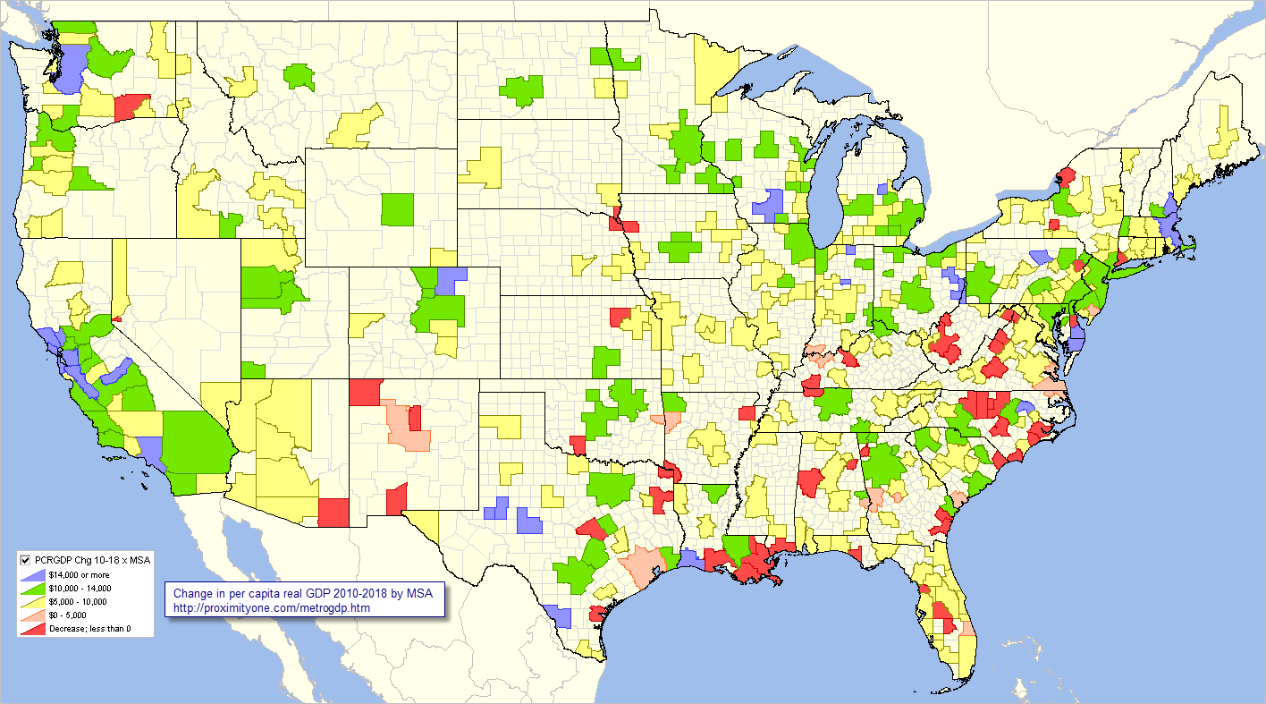 -- view created using ProximityOne CV XE GIS and associated GIS project Top 25 Metros (MSAs) based on 2018 per capita real GDP The following graphic shows the top 25 metros (MSAs) based on 2018 per capita real GDP labeled with rank. Click graphic for larger view. Expand browser to full window for best quality view. 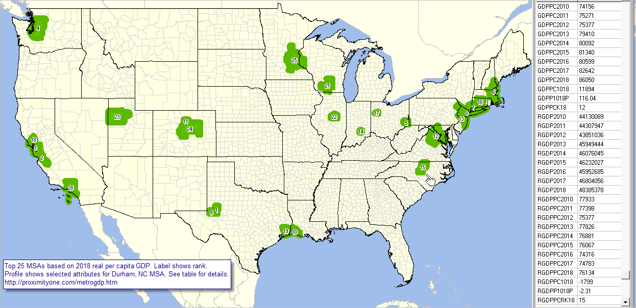 -- view created using ProximityOne CV XE GIS and associated GIS project Click to view selected zoom-in views ... • Selected NC metros Metro Situation & Outlook Reports View Metro GDP Characteristics section in the Metropolitan Area Situation & Outlook Reports, providing the same scope of data as in the table below integrated with other data. See example for the Dallas, TX MSA. GDP tells an important but small part of the broader metro demographic-economic characteristics. Most metros have sub-county areas experiencing growth or activity sometimes masked when looking at the entire metro. Click a metro (metro GDP estimated for MSAs only) link in the table at upper right to view the GDP estimate in context of related subject matter. Use the CV XE GIS software and MetroGDP GIS project to create thematic pattern maps and integrate the employment situation data with other data. ProximityOne User Group members may install the MetroGDP GIS Project (see below) and prepare thematic pattern maps like the one shown above. Metropolitan Area Gross Domestic Product: 2010-2018 -- Interactive Table .. goto top Table contains one row for each MSA with subject matter arrayed across columns. There are four column sets containing data for each year 2010 - 2018. Click ShowAll button between Find/Queries. See usage notes below ranking table. See related demographic-economic interactive tables Usage Notes .. goto top • Click ShowAll button between specific queries. • GDP in thousands of dollars, expect per capita. • Click a column header to sort on that column; click again to sort other direction. Columns/Items in the Table -- scroll section: .. illustrating data for the Houston-The Woodlands-Sugar Land, TX MSA
Illustrative Industry Detail Available for each MSA .. goto top .. using data for the Houston-The Woodlands-Sugar Land, TX MSA & two years: 2010 & 2018; series runs 2001-2018. .. Real GDP in thousands of 2012 dollars. (D) indicates estimate not available. .. scroll section:
Using the MetroGDP GIS Project .. goto top Use the MetroGDP GIS Project to develop maps, such as those shown above, and perform geospatial analysis operations. Steps to develop custom thematic pattern maps are summarized below (requires Windows computer with Internet connection) 1. Install the ProximityOne CV XE GIS ... run the CV XE GIS installer ... take all defaults during installation 2. Download the MetroGDP GIS project fileset ... requires ProximityOne User Group ID (join now) ... unzip MetroGDP GIS project files to local folder c:\metrogdp2014 3. Open the c:\metrogdp2014\metrogdp2014.gis project ... after completing the above steps, click File>Open>Dialog ... open the file named c:\metrogdp2014\metrogdp2014.gis 4. Done. The start-up view is shown at top of this section. About these Data goto top Gross Domestic Product (GDP) is a comprehensive measure of the economies of counties, metropolitan statistical areas and other areas. GDP estimates the value of the goods and services produced in an area. It can be used to compare the size and growth of economies across the nation. The Bureau of Economic Analysis develops annual estimates of gross domestic product (GDP) for each metropolitan statistical area. Estimates of real GDP by metropolitan area are developed in chained (2012) dollars. Real GDP by metropolitan area is an inflation-adjusted measure of each area's gross domestic product that is based on national prices for the goods and services produced within the metropolitan area. Real GDP by metropolitan area and of quantity indexes with a reference year of 2012 were derived by applying national chain-type price indexes to the current-dollar GDP-by-metropolitan-area values for the 61 detailed NAICS-based industries. Sep 2018 CBSA/MSA Delineations On September 14, 2018, OMB posted "OMB Bulletin No. 18-04, Revised Delineations of Metropolitan Statistical Areas, Micropolitan Statistical Areas, and Combined Statistical Areas, and Guidance on Uses of the Delineations of These Areas". • View 2018 Vintage MSA-County Components Table with population estimates. • OMB bulletin http://proximityone.com/metros/Bulletin-18-04.pdf. • Many 2018 Vintage CBSAs are comprised of a different/modified set of component counties as compared to the Vintage 2017 CBSAs. • County-to-CBSA equivalence files and shapefiles available. ProximityOne User Group Join the ProximityOne User Group to keep up-to-date with new developments relating to metros and component geography decision-making information resources. Receive updates and access to tools and resources available only to members. Use this form to join the User Group. Support Using these Resources Learn more about accessing and using demographic-economic data and related analytical tools. Join us in a Data Analytics Lab session. There is no fee for these one-hour Web sessions. Each informal session is focused on a specific topic. The open structure also provides for Q&A and discussion of application issues of interest to participants. Additional Information ProximityOne develops geodemographic-economic data and analytical tools and helps organizations knit together and use diverse data in a decision-making and analytical framework. We develop custom demographic/economic estimates and projections, develop geographic and geocoded address files, and assist with impact and geospatial analyses. Wide-ranging organizations use our tools (software, data, methodologies) to analyze their own data integrated with other data. Follow ProximityOne on Twitter at www.twitter.com/proximityone. Contact us (888-364-7656) with questions about data covered in this section or to discuss custom estimates, projections or analyses for your areas of interest. |
|
|