
|
|
|
-- Monthly Employment-Unemployment Characteristics & Trends -- Census Tract, County & Metro August 2020 .. current, longitudinal data on the employment situation are essential to assess recent demographic-economic trends. This section provides access to tools and data to analyze the local area employment situation and how it is changing month-to-month. Use the interactive table below to view, query, rank and analyze county/metro employment characteristics and trends. Examine counties in a selected state, metro or peer group. Develop maps and geospatially analyze these data using GIS resources. Integrate these with other data and geography to obtain a more comprehensive picture of the local/regional economy -- and visually compare regions. Combine these data with your data to assess opportunities, resource allocation and competitive position. Visual Analysis of Patterns of the Employment Situation by Census Tract: Houston, Texas Area The following graphic shows patterns of the unemployment rate by census tract. Use the VDA Mapserver to develop variations of this view optionally integrated with other data. See more about these data - Counties shown with black boundary - Map view shows patterns of June 2020 unemployment rate by census tract - Intervals/color pattern shown in Legend at lower left - Profile for selected tract (blue highlight in map) shown in Attributes panel at left of map Click graphic for larger view. Expand browser window for best quality view. 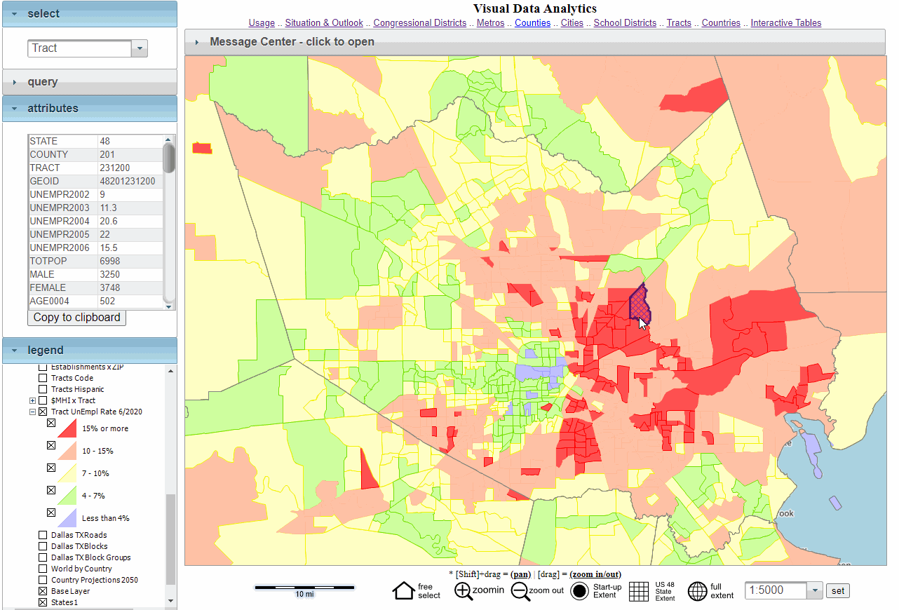 -- view created using the VDA Mapserver To create a similar view, proceed as follows: Start the mapserver -- even if in operation, restart. - at login page click "Proceed without Account" - uncheck the Metros layer in the Legend Panel. - in Query dropdown (left) select click County query button. - click the "Tract Unempl Rate" layer on in the legend panel. - click the [+] button to left of layer name (expanding/showing the interval view) - the map window refreshes to show the view shown above - in Select dropdown, select Tract. - optionally click on a tract; the attribute panel populates with the attributes. - Examining the Attribute grid, attributes of selected tract can be viewed; optionally copied to clipboard. Visual Analysis of Patterns of the Employment Situation by County The following graphic shows patterns of the unemployment rate by county. Use the VDA Mapserver to develop variations of this view optionally integrated with other data. - Map view shows patterns of June 2020 unemployment rate by county - Intervals/color pattern shown in Legend at lower left - Profile for Harris, County, TX - blue highlight in map shown in Attributes panel at left of map Click graphic for larger view. Expand browser window for best quality view. 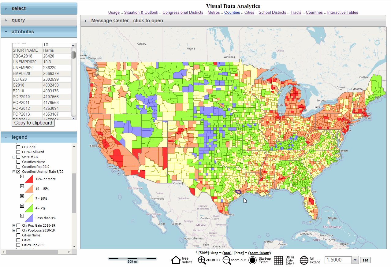 -- view created using the VDA Mapserver To create a similar view, proceed as follows: Start the mapserver -- even if in operation, restart. - at login page click "Proceed without Account" - uncheck the Metros layer in the Legend Panel. - click the "County Unempl Rate" layer on in the legend panel. - click the [+] button to left of layer name (expanding/showing the interval view) - the map window refreshes to show the view shown above - in Select dropdown, select County - optionally click on a click a county; the attribute panel populates with the attributes of the selected county. - Examining the Attribute grid, attributes of selected county can be viewed; optionally copied to clipboard. Employment Situation by County and CBSA/Metro -- Interactive Table Data for May 2019 - June 2020; updates monthly Click ShowAll button between Find/Queries. See usage notes below table. See related interactive tables. Column headers: UR: unemployment rate, UnEmp: unemployment, Emply: employment, CLF: labor force Usage Notes • The CBSA/Metro code used in the table is based on the current Sep 2018 CBSA vintage. • Click ShowAll button between specific queries. • Data in the table are not seasonally adjusted. • Headings: UR: Unemployment Rate; UnEmp: Unemployment; Emply: Employment; CLF: Civilian Labor Force. • Click a column header to sort on that column; click again to sort other direction. Viewing data for latest month and 12 preceding months by type: • Click UnempRate button below table to view only unemployment rate columns • Click Unemp button below table to view only unemployment columns • Click Emply button below table to view only employment columns • Click CLF button below table to view only civilian labor force columns Examine peer groups based on total population: • Click ShowAll button between specific queries. • Enter min and max population values in edit boxes; click Pop18 button; table refreshes. About the LAES GIS Project Use the LAES GIS Project to develop maps, such as those shown above, and perform geospatial analysis operations. The LAES GIS Project updates monthly as new data become available. Steps to develop custom thematic pattern maps are summarized below (requires Windows computer with Internet connection) 1. Install the ProximityOne CVGIS software ... run the CV XE GIS installer ... take all defaults during installation 2. Download the LAES GIS project fileset ... requires UserID ... unzip LAES GIS project files to local folder c:\laes 3. Open the c:\laes\laes1.gis project ... after completing the above steps, click File>Open>Dialog ... open the file named c:\laes\laes1.gis 4. Done. The start-up view is shown at top of this section. Scope and Use of these Data goto top The underlying employment-related data for used in this section are developed by the Bureau of Labor Statistics (BLS). The BLS Local Area Unemployment Statistics (LAUS) develops monthly estimates of the civilian labor force, employment, unemployment and unemployment rate for metropolitan areas, counties and sub-county areas. Population data in the table are from the Census Bureau model-based estimates developed annually. The population and components of change estimates are released in March. See more about the population and components of change estimates data. The ProximityOne Local Area Employment Situation (LAES) program extends the scope of these data and provides tools to analyze patterns and characteristics. Options include: • LAES Option 1 .. extended interactive table access .. includes counties, metros, states and the U.S. .. enables downloading monthly updates/time series file. • LAES Option 2 .. Option 1 plus additional features .. projections six months ahead. .. downloadable data in shapefile structure for mapping/geospatial analysis. .. ready-to-use GIS project with CV XE GIS software. Related Data goto top • Situation & Outlook data base and information system • Guide to Local Area Labor Force Data ProximityOne User Group Join the ProximityOne User Group to keep up-to-date with new developments relating to metros and component geography decision-making information resources. Receive updates and access to tools and resources available only to members. Use this form to join the User Group. Support Using these Resources Learn more about accessing and using demographic-economic data and related analytical tools. Join us in a Data Analytics Lab session. There is no fee for these one-hour Web sessions. Each informal session is focused on a specific topic. The open structure also provides for Q&A and discussion of application issues of interest to participants. Additional Information We are continuously watching and analyzing the economy .. from the national to sub-county levels. And sharing this information with you. This section is about one part of of it. We develop, organize and and integrate the pieces for a more holistic look and assess how change might affect us in the months and years ahead. ProximityOne develops geodemographic-economic data and analytical tools and helps organizations knit together and use diverse data in a decision-making and analytical framework. We develop custom demographic/economic estimates and projections, develop geographic and geocoded address files, and assist with impact and geospatial analyses. Wide-ranging organizations use our tools (software, data, methodologies) to analyze their own data integrated with other data. Follow ProximityOne on Twitter at www.twitter.com/proximityone. Contact us (888-364-7656) with questions about data covered in this section or to discuss custom estimates, projections or analyses for your areas of interest. |
|
|