
|
|
|
County to County Domestic Migration - movers between counties; all counties
.. which counties are experiencing increases or decreases in domestic migration? What is the size of the population migrating from one county to each specific destination county? Conversely, what is the size of the population migrating into one county from each specific county of origin? How might this migration impact your areas of interest? Use the interactive table below to examine these characteristics and patterns county by county. What about Fresno? How is migration affecting the population dynamics in Fresno County, CA? What county or other country are inbound movers coming from? How many and how do contributors rank? Where are Fresno County outbound movers moving? How many movers and how to destinations rank? What is the gross and net mover situation? Find out using these step-by-step instructions below the interactive table. Use these steps in your counties of interest. Visualizing Domestic Migration Change by County The following graphic shows patterns of county domestic migration over the period 2011 to 2017. Intervals/colors of the total 2011-2017 (sum across years) domestic migration per 1,000 2017 population are shown in the inset legend. Domestic migration is one component of population change. See this related interactive table to view/analyze domestic migration in context of total population and other components of change. The largest 20 metros based on 2017 population are shown with bold black boundaries. Click graphic for larger view; expand screen for best quality view. 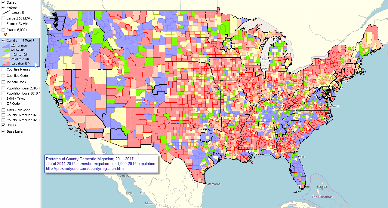 - View developed with CV XE GIS software. Using the Interactive Table .. goto top The interactive table shown below includes a row for each U.S. county (County A) and each county (County B) for which there were population movers into County A from County B during the past year. These data can be envisioned as a 3,142 by 3,142 cell (number of U.S. counties) origin-destination matrix. The data are for a one year period. Corresponding data exist for prior years. These data are used in ProximityOne Situation & Outlook models to develop more current estimates and projections. County to County Domestic Migration; Movers from 1 Year Ago -- Interactive Table Use mouseover on header column to view extended item/column name. See usage notes below table. Examining County Migration .. an Example using Fresno County, CA ... looking just below the green & white interactive table ... • Click ShowAll/Reset button below table. • Click the button Find StCtyA .. note the county of interest is set to 06019 (Fresno County) .. the table refreshes showing only StCtyA rows (column 1) • Sort the table on FB2A header cell (from StCtyB to StCtyA) - click FB2A twice .. movers moving into Fresno County by Area of Origin (StCtyB) are now ranked in descending order) .. see that there are 2,922 people moving from Madera County, CA to Fresno County, CA -- movers moving during the past year .. note that the 3rd highest number of inbound movers was from Asia. .. see that the counter flow of StCtyA to StCtyB is 2,076 (col CFA2B). .. see that the net flow of movers between StCtyA and StCtyB is 846 (col NMB2A0) to Fresno. .. see that the gross flow of StCtyA and StCtyB is 4,998 (col GMAB). Usage Notes • Data are included in the table for counties in the U.S. • Click ShowAll button between queries; this resets the table. • Click on a column header to sort on that column; click column header again to sort in other direction. • Click State to select on geographies in a selected state (click ShowAll between selections). Support Using these Resources .. goto top Learn more about accessing and using demographic-economic data and related analytical tools. Join us in a Data Analytics Lab session. There is no fee for these one-hour Web sessions. Each informal session is focused on a specific topic. The open structure also provides for Q&A and discussion of application issues of interest to participants. ProximityOne User Group Join the ProximityOne User Group to keep up-to-date with new developments relating to geographic-demographic-economic decision-making information resources. Receive updates and access to tools and resources available only to members. Use this form to join the User Group. Additional Information ProximityOne develops geographic-demographic-economic data and analytical tools and helps organizations knit together and use diverse data in a decision-making and analytical framework. We develop custom demographic/economic estimates and projections, develop geographic and geocoded address files, and assist with impact and geospatial analyses. Wide-ranging organizations use our tools (software, data, methodologies) to analyze their own data integrated with other data. Follow ProximityOne on Twitter at www.twitter.com/proximityone. Contact ProximityOne (888-364-7656) with questions about data covered in this section or to discuss custom estimates, projections or analyses for your areas of interest. |
|
|