
|
|
|
.. resources to build maps and perform geoanalytics .. TIGER 2022 digital map database (annual update) released October 2022 October 2022 .. the Census Bureau TIGER digital map database, released annually, is a set of shapefiles and related files (details below) that provide a unique resource to map and geospatially analyze geography covering the U.S. wall-to-wall. Use these geographic data resources with the ProximityOne CV XE GIS desktop and the Visual Data Analytics (VDA) Web GIS -- a resource of ProximityOne and Tsukasa Consulting (Osaka, Japan). MapBuilder 2022 -- Using CV XE GIS with TIGER (multi-vintage) Build your own maps from scratch .. do more, more efficiently. With CV XE GIS (version 10.03.22 or later), start File>GeoGateway Access, download detailed roads (edges) TIGER 2022 shapefile for Fresno County, CA. 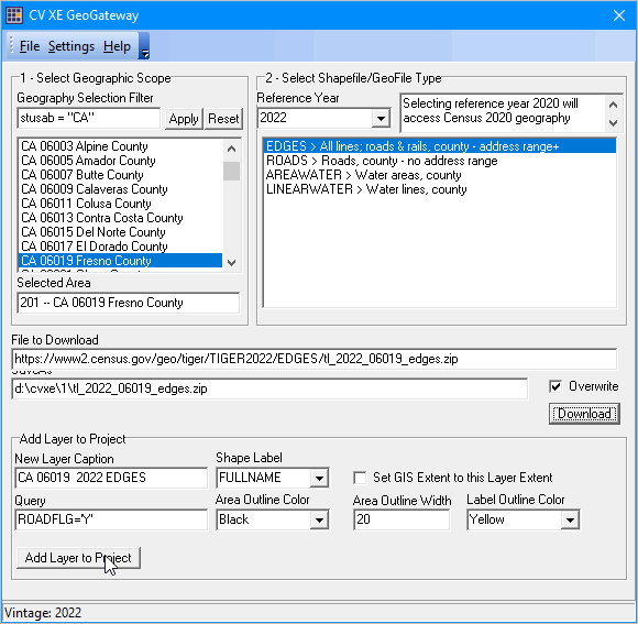 Four clicks to add the shapefile to any project. Intersection to intersection road/street detail. .. do this for any county in the U.S. 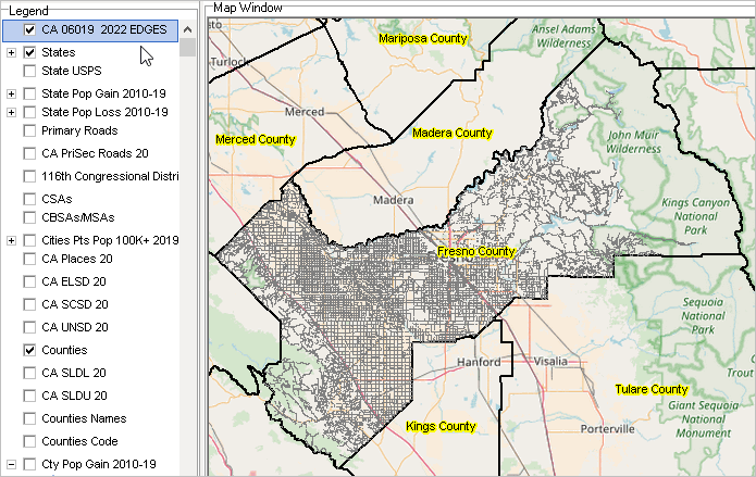 How Does this Work? Watch this Video .. goto top .. MapBuilder -- GeoGateway2022 Video Using VDA Web GIS to Examine TIGER-based Roads .. goto top The following graphic illustrates use of VDA Web GIS with the MetroDynamics project to query/show "W Sunset Blvd" in Los Angeles County (371 street segments) highlighted in green; see pointer. Table shows tabular view of road segments. This application uses the TIGER-based roads/edges layer, part of this GIS project.  TIGER 2022 .. goto top The Census Bureau TIGER 2022 digital map database was released in October 2022. The 2022 TIGER/Line Shapefiles contain current geographic extent and boundaries of both legal and statistical entities for the states, D.C., Puerto Rico and island areas. This vintage includes boundaries of governmental units that match data from the surveys that use 2022 geography (e.g., the 2022 American Community Survey). TIGER files contain only geographic data. Use the Demographic Economic Data Explorer (DEDE) to extract subject matter data and integrate into your downloaded TIGER shapefiles. Make thematic pattern maps. TIGER GeoDatabase.. goto top The Census Bureau TIGER shapefiles contain data that can be used to represent different types of point, line, and polygon geography covering the U.S. earth surface. More about TIGER. The TIGER shapefiles, and related derivative products, play an important role in wide-ranging geospatial analyses and decision-making information solutions. Warren Glimpse, founder of ProximityOne, developed the Columbia, MO GBF/DIME file used as the prototype for the TIGER/Line program and is developer of CV XE GIS desktop and Web-based GIS applications/tools that facilitate use of the TIGER/Line data with other wide-ranging data in applications such as pattern/trend analysis, geospatial processing and location-based operations. TIGER 2022 -- More Detailed Look .. goto top The 2022 TIGER/Line Shapefiles contain current geographic extent and boundaries of both legal and statistical entities, like census tracts, for the U.S. This vintage includes boundaries of governmental units that match the data from the surveys that use 2022 geography (e.g., the 2022 American Community Survey). In addition to geographic boundaries, the 2022 TIGER/Line Shapefiles also include geographic feature shapefiles and relationship files. Feature shapefiles represent the point, line, and polygon features in the MAF/TIGER System (e.g., roads and rivers). Relationship files contain additional attribute information users can join to the shapefiles. Both the feature shapefiles and relationship files reflect updates made in the database through May 2022. View how the geographic entities, relate to one another, See this graphic. Legal entity shapefiles • American Indian Off-Reservation Trust Lands • American Indian Reservations – Federal • American Indian Reservations – State • American Indian Tribal Subdivisions (within legal American Indian areas) • Alaska Native Regional Corporations • Congressional Districts – 116th Congress • Consolidated Cities • Counties and Equivalent Entities (except census areas in Alaska) • Estates (U.S. Virgin Islands only) • Hawaiian Home Lands • Incorporated Places • Minor Civil Divisions • School Districts – Administrative • School Districts – Elementary • School Districts – Secondary • School Districts – Unified • States and Equivalent Entities • State Legislative Districts – Upper • State Legislative Districts – Lower • Subminor Civil Divisions (Subbarrios in Puerto Rico) Statistical entity shapefiles • Alaska Native Village Statistical Areas • American Indian/Alaska Native Statistical Areas • American Indian Tribal Subdivisions (within Oklahoma Tribal Statistical Areas) • Block Groups • Census Areas • Census Blocks • Census County Divisions (Census Subareas in Alaska) • Unorganized Territories (statistical county subdivisions) • Census Designated Places (CDPs) • Census Tracts • Oklahoma Tribal Statistical Areas • Public Use Microdata Areas (PUMAs) • State Designated Tribal Statistical Areas • Tribal Designated Statistical Areas • Urban Areas • ZIP Code Tabulation Areas (ZCTAs) Feature shapefiles • Address Range-Feature • All Lines (called Edges) • All Roads • Area Hydrography • Area Landmark • Coastline • Linear Hydrography • Military Installation • Point Landmark • Primary Roads • Primary and Secondary Roads • Topological Faces (polygons with all geocodes) Relationship Files • Address Range-Feature Name • Address Ranges • Feature Names • Topological Faces – Area Landmark • Topological Faces – Area Hydrography • Topological Faces – Military Installations Additional Information .. goto top ProximityOne develops geodemographic-economic data and analytical tools and helps organizations knit together and use diverse data in a decision-making and analytical framework. We develop custom demographic/economic estimates and projections, develop geographic and geocoded address files, and assist with impact and geospatial analyses. Wide-ranging organizations use our tools (software, data, methodologies) to analyze their own data integrated with other data. Follow ProximityOne on Twitter at www.twitter.com/proximityone. Contact us (888-364-7656) with questions about data covered in this section or to discuss custom estimates, projections or analyses for your areas of interest. |
|
|