
|
|
|
-- prepare now to engage in Census 2020 redistricting -- use resources and processes outlined here updating as we move toward live Census 2020 redistricting data (March 2021) Redistricting is the process of developing a redistricting plan for 2 or more areas (districts) disjoint and contiguous that are contained within the collective area of all districts based on some criteria. Redistricting is perhaps most familiar with regard to congressional districts and state legislative districts based on a set of demographic characteristics. Redistricting applies to many other types of areas such as cities, school districts and business applications such as sales, marketing and management territories. The focus here is on redistricting applied to congressional districts (CDs) and state legislative districts (SLDs). Follow the frequently updated Census 2020 Calendar on key data development/access steps. This section has been developed by Warren Glimpse, founder of ProximityOne, developer of tools used in this section and specialist in the use of geodemographics and political/statistical geography. Objectives The objective of this section is to enable anyone having a Windows-based computer and access to Internet to examine an existing CD or SLD redistricting plan in any state at no cost. Use the resources and steps reviewed here to perform those operations and examine census block level demographics. View selected districts and related political/statistical geography. Getting Started Use of these resources requires your Congressional District/State Legislative District (CDSLD) group userid. Join here; no cost. Learn more about redistricting operations use of these resources. Participate in the no cost weekly Data Analytics Lab Web Sessions to ask questions and get answers about use of these resources. Overview This section reviews the process of redistricting Virginia house state legislative districts based on Census 2010 P.L 94-171 data using current definition 2016 cycle SLD boundaries. Use this tutorial to review the required resources and step through the process of redistricting as it might apply to the use of Census 2020 data. See the related background document Designing P.L. 94-171 Redistricting Data for Census 2020. Using the information and tools reviewed here, you can emulate the process of redistricting the VA House SLDs (or any state) using your Windows computer. Virginia 115th Congressional Districts - 11 congressional districts - with census blocks layer (blue: water, orange: urban) - click graphic for larger view; expand browser window for best quality view 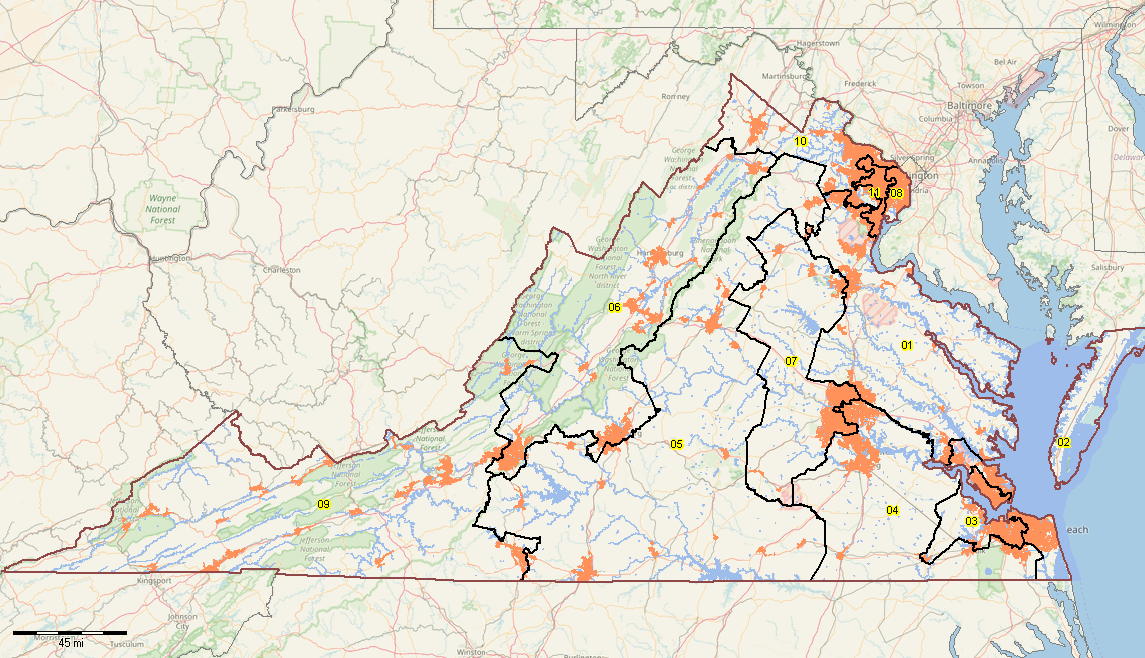 - click graphic for better quality view - developed using the CV XE GIS software and related GIS project Virginia State Legislative Districts Upper (SLDU) - 40 SLDUs - with census blocks layer (blue: water, orange: urban) - click graphic for larger view; expand browser window for best quality view 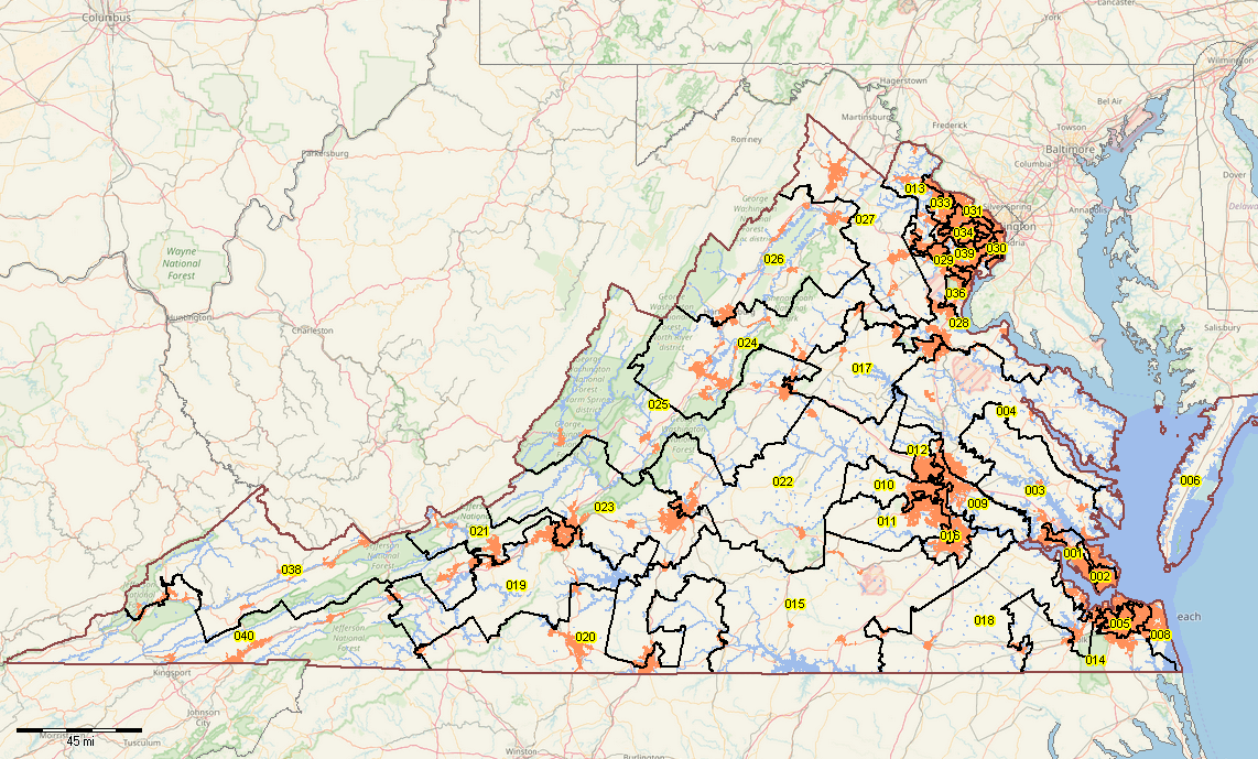 - click graphic for better quality view - developed using the CV XE GIS software and related GIS project Virginia State Legislative Districts Lower (SLDL) - 100 SLDLs - with census blocks layer (blue: water, orange: urban) - click graphic for larger view; expand browser window for best quality view 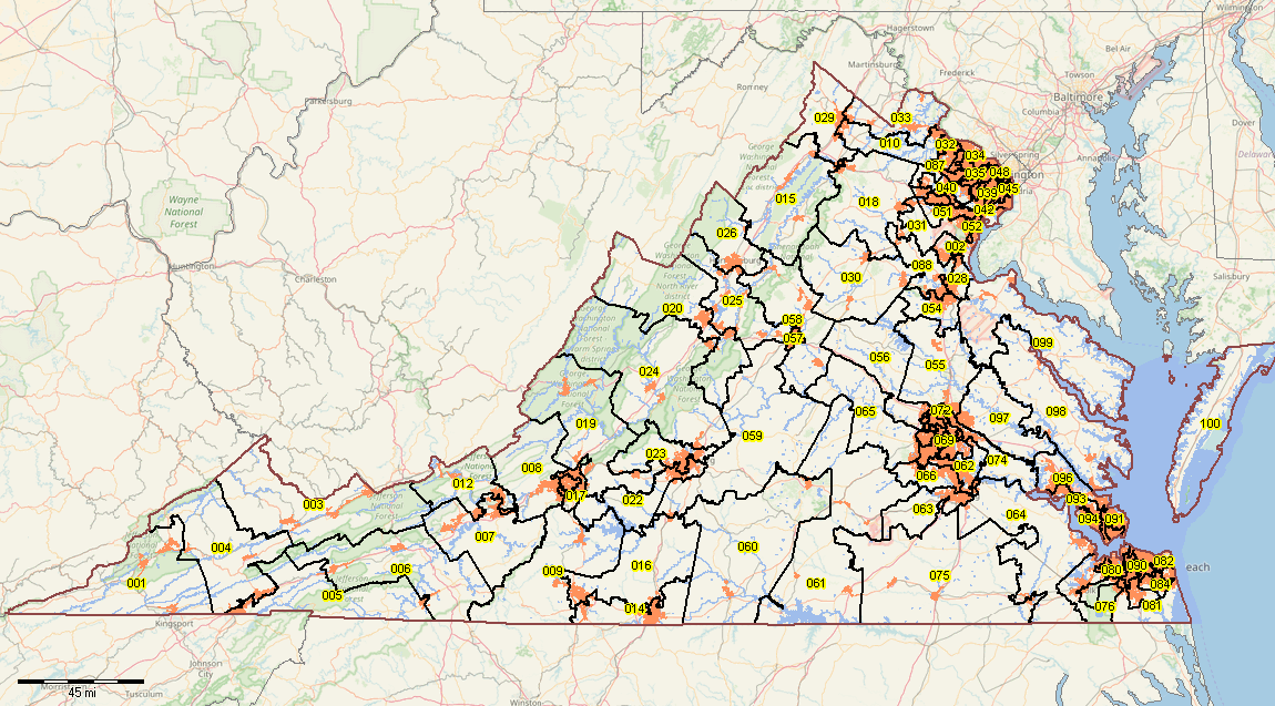 - click graphic for better quality view - developed using the CV XE GIS software and related GIS project Requirements for Redistricting Requirements for CDs/SLDs are the same for any state:. 1. Existing VA plan (represented by VA House SLD boundaries) 2. VA P.L 94-171 census block level demographic data 3. VA Census Blocks Shapefile 4. VA House SLD to census block equivalency file 5. CV XE GIS software with redistricting feature 6. Redistricting criteria and design framework Software and GIS Project Installation .. goto top We start with the ready-to-use GIS project. After you see the redistricting process in operation, we go back and review the components and steps to develop a similar GIS Redistricting project and operation for any state and related CDS or SLDs. Installation requirements include: • Windows computer with Internet connection • Userid and password provided separately .. to obtain CDSLD userid and password, register here. • Agree to Terms of Use Terms of Use .. goto top • The software nor data provided may be redistributed in any manner. • No fee can be charged for direct of indirect use of the software or data. • The data are used only with the CV XE GIS software. • There is no warranty of any type with respect to any aspect of the software or data. Follow these steps to install the GIS project and related data files. 1. Install the CV XE GIS software ... run the CV XE GIS installer ... take all defaults during installation ... the GIS project described below may be used with any CV XE GIS version/level 2.1. Create a new folder c:\cdsld ... if that folder exists, rename it to c:\cdsld_old then create the folder c:\cdsld 2.2. Install the CDSLD_VA GIS project fileset ... unzip CDSLD_VA GIS project files to local folder c:\cdsld ... please confirm that the project files have been unzipped to the folder c:\cdsld. 3. Open the c:\cdsld\cdsld_va.gis project ... start CV XE GIS using the desktop icon ... click File>Open>Dialog ... open the file named c:\cdsld\cdsld_va.gis 4. Done. The start-up view is appears as shown above. Next Steps: Using the CDSLD GIS project & Redistricting/Census 2020 1. See related section on using the CDSLD_VA GIS project 2. See related section Redistricting & Census 2020 next steps ... requires your CDSLD group userid; Join here; no cost. Support Using these Resources .. goto top Learn more about demographic economic data and related analytical tools. Join us in a Data Analytics Lab session. There is no fee for these Web sessions. Each informal session is focused on a specific topic. The open structure also provides for Q&A and discussion of application issues of interest to participants. ProximityOne User Group .. goto top Join the ProximityOne User Group to keep up-to-date with new developments relating to geographic-demographic-economic decision-making information resources. Receive updates and access to tools and resources available only to members.Use this form to join the User Group. Additional Information ProximityOne develops geodemographic-economic data and analytical tools and helps organizations knit together and use diverse data in a decision-making and analytical framework. We develop custom demographic/economic estimates and projections, develop geographic and geocoded address files, and assist with impact and geospatial analyses. Wide-ranging organizations use our tools (software, data, methodologies) to analyze their own data integrated with other data. Follow ProximityOne on Twitter at www.twitter.com/proximityone. Contact us (888-364-7656) with questions about data covered in this section or to discuss custom estimates, projections or analyses for your areas of interest. |
|
|